Kungsleden Winter Trek - The King of Arctic Trails
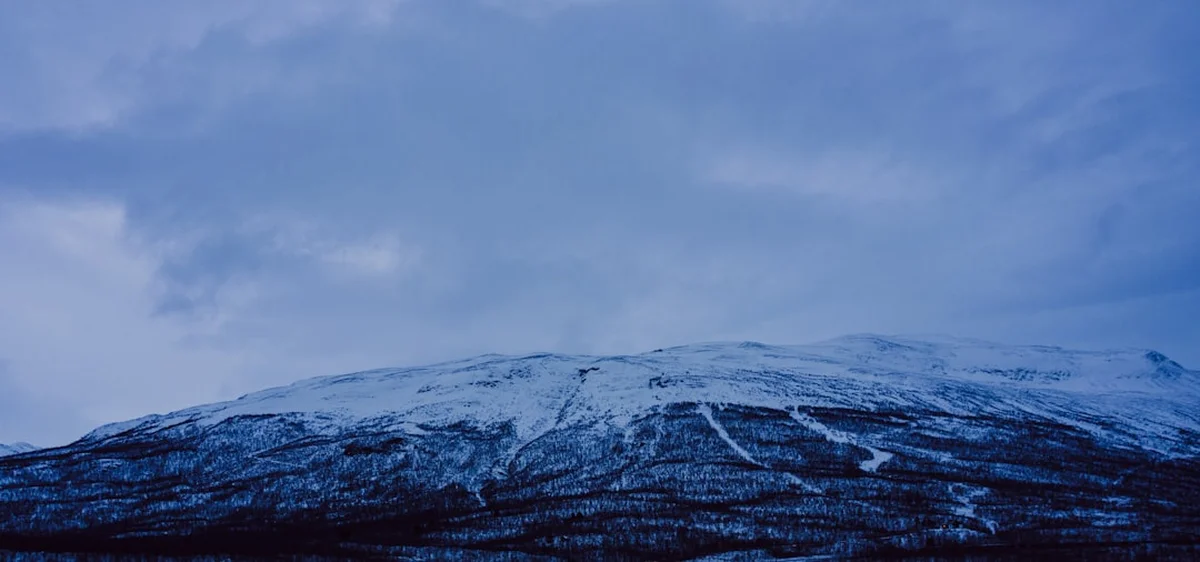
The Kungsleden, or "The King's Trail," is Sweden's most famous long-distance path, stretching approximately 440 kilometres through the heart of the Scandinavian Mountains. While thousands traverse its rocky paths in the summer, the winter transformation turns this landscape into one of the world's premier cross-country ski touring destinations. Traversing from Abisko in the north to Hemavan in the south, the trail crosses four national parks—Abisko, Stora Sjöfallet, Sarek, and Pieljekaise—and passes through the ancestral lands of the Sami people. In winter, the rugged terrain is smoothed by a deep mantle of snow, the lakes become frozen highways, and the sky is frequently illuminated by the ethereal dance of the Aurora Borealis.
A winter expedition on the Kungsleden is a serious undertaking that demands respect for the Arctic environment. Unlike the summer trek, the winter version requires specialised equipment, including backcountry skis or snowshoes, and the ability to navigate in whiteout conditions. The route is marked by distinctive red "winter crosses" (Vintermarkering), which are essential for navigation when the trail itself is buried under metres of snow. This is a journey of profound silence, where the only sound is the rhythmic glide of skis and the occasional whistle of the wind across the tundra. It offers a rare opportunity to experience true wilderness on a grand scale, moving between remote mountain huts that provide a warm sanctuary against the sub-zero temperatures of the Swedish Lapland.
- Distance: 440 km one-way (Abisko to Hemavan)
- Duration: 20–30 days for the full traverse
- Season: February to April (Huts are staffed; daylight returns; snow is stable)
- Accommodation: STF Mountain Huts and Stations (Svenska Turistföreningen)
- Highest point: Tjäktja Pass (1,150 m)
- Difficulty: Challenging (Requires winter camping skills or hut-to-hut experience)
- Direction: Traditionally North to South (Abisko to Hemavan)
Overview
The Kungsleden Winter Trek is a masterclass in Arctic geography. The trail is divided into several distinct sections, each offering a unique landscape. The northernmost section, from Abisko to Kebnekaise, is the most popular and dramatic, featuring deep U-shaped valleys, high alpine passes, and the towering massif of Sweden's highest peak. As you move south, the landscape transitions into vast, rolling plateaus and ancient birch forests, eventually reaching the more isolated stretches between Kvikkjokk and Ammarnäs, where the sense of solitude is absolute. The final leg to Hemavan traverses the Vindelfjällen Nature Reserve, one of the largest protected areas in Europe, characterised by its wide valleys and gentle gradients.
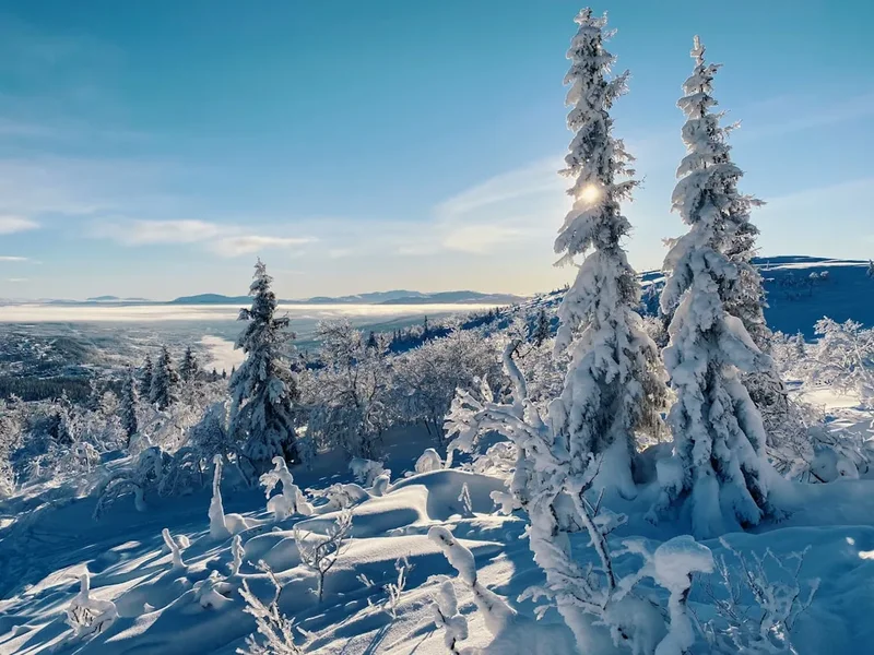
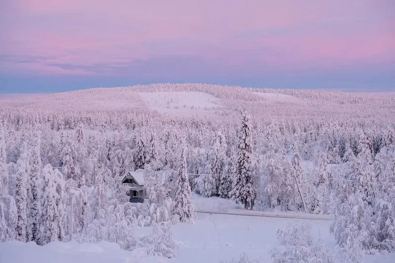
Travelling in winter changes the fundamental nature of the trail. Distances that seem manageable in summer can become gruelling in deep snow or against a fierce headwind. Conversely, the freezing of the great lakes—such as Teusajaure and Langas—allows skiers to cut straight across the ice, bypassing the undulating shoreline paths used by summer hikers. The weather is the primary protagonist of any Kungsleden winter story. Temperatures can plummet to -30°C, and storms can roll in with terrifying speed, reducing visibility to a few metres. However, on clear days, the Arctic light is incomparable, casting long, blue shadows across the sparkling snow and turning the mountains into a canvas of pink and gold at sunset.
The infrastructure provided by the Svenska Turistföreningen (STF) is what makes this expedition possible for those not wishing to carry a full winter tent setup. A network of mountain huts (stugor) is spaced roughly 10 to 20 kilometres apart. These huts are more than just shelters; they are cultural hubs where travellers from around the world gather to chop wood, haul water from ice holes, and share stories by the warmth of a wood-burning stove. Many huts also feature traditional wood-fired saunas—a quintessential Swedish experience that provides much-needed recovery for tired muscles after a long day on the trail. This blend of raw wilderness and cosy communal living creates a trekking experience that is both physically demanding and deeply rewarding.
History and Cultural Context
The Kungsleden was the brainchild of the Svenska Turistföreningen (STF), formed in the late 19th century with the goal of making the Swedish mountains accessible to the public. The idea for a "King's Trail" was first proposed around 1900, with the intention of creating a continuous path through the most beautiful parts of the Lapland wilderness. Construction began in the early 20th century, with the first sections between Abisko and Kvikkjokk being established by the 1920s. The trail was not fully completed to Hemavan until 1975, marking the culmination of over seventy years of trail-building and hut construction.
However, the history of this land stretches back thousands of years before the first tourists arrived. The Kungsleden passes through Sápmi, the traditional territory of the Sami people. For generations, the Sami have lived in harmony with this environment, following the seasonal migrations of their reindeer herds. The trail intersects with many ancient reindeer herding routes, and walkers will often see Sami settlements (visten) and reindeer enclosures along the way. In winter, the reindeer are often moved to lower elevations or forest areas, but their presence is felt in the names of the mountains and valleys—names like Kebnekaise (Cauldron Crest) and Tjäktja (Highland)—which are derived from the Northern Sami language.
The development of the trail was a monumental task of engineering and logistics. Building huts in such remote locations required materials to be hauled by horse-drawn sleds or, in later years, by snowmobile and helicopter. The trail was designed to showcase the diversity of the Swedish landscape, from the lush birch forests of the valleys to the stark, treeless tundra of the high plateaus. Today, the Kungsleden is not just a hiking trail; it is a symbol of the Swedish "Allemansrätten" (the Right of Public Access), which allows everyone the freedom to roam the countryside, provided they do so with respect for nature and landowners.
Want more background? Read extended notes on history and cultural context → Learn more
Seasonal Highlights and Weather Reality
The winter season on the Kungsleden typically runs from February to late April. Attempting the trail outside of this window is not recommended for most trekkers. In December and January, the Arctic Circle experiences the "Polar Night," where the sun does not rise above the horizon. During this time, temperatures are at their lowest, and the mountain huts are generally unstaffed and closed, except for emergency rooms. The snow is often powdery and unstable, making travel extremely difficult.
February marks the beginning of the winter trekking season. The sun returns, providing a few hours of daylight that gradually increase each day. This is the best time for those seeking the Northern Lights, as the nights are still long and dark. However, February is also the coldest month, with temperatures frequently dropping below -20°C. By March, the days are longer, and the sun begins to provide some warmth. The snowpack becomes more consolidated, making for better skiing conditions. This is often considered the "golden period" of the winter trek, offering a balance of good light, stable snow, and manageable temperatures.
April brings the "Spring-Winter" (vårvinter), a favourite season for locals. The days are long, and the sun can be surprisingly intense, requiring high-factor sunscreen to prevent snow blindness and burns. While the daytime temperatures may rise above freezing, the nights remain cold. By late April, the snow begins to melt at lower elevations, and the ice on the lakes can become unstable. This is the end of the season; once the spring thaw (vårflod) begins in May, the trail becomes a mixture of slush, mud, and rushing meltwater, making it impassable until the summer season begins in late June.
Recommended Itinerary
The Full Kungsleden Winter Traverse (Abisko to Hemavan)
Stage 1: The Northern Wilderness (Abisko to Singi)
- Distance: 75 km
- Duration: 5–6 days
- Key Waypoints: Abiskojaure, Alesjaure, Tjäktja, Sälka
- Start at the Abisko Turiststation, easily reached by train from Kiruna.
- Ski through the birch forests of Abisko National Park to Abiskojaure Hut.
- Ascend onto the high tundra towards Alesjaure, one of the largest hut complexes on the trail.
- Cross the Tjäktja Pass (1,150 m), the highest point on the Kungsleden, often requiring careful navigation in wind.
- Descend into the majestic Tjäktja Valley, staying at Sälka Hut, famous for its remote sauna.
- Reach Singi, the junction for the detour to Kebnekaise Mountain Station.
Stage 2: The Great Lakes and Sarek Borders (Singi to Saltoluokta)
- Distance: 70 km
- Duration: 4–5 days
- Key Waypoints: Kaitumjaure, Teusajaure, Vakkotavare, Saltoluokta
- Travel south from Singi through narrow valleys to the beautiful Kaitumjaure Hut.
- Cross the plateau to Teusajaure, where you must ski across the frozen lake.
- A steep descent leads to Vakkotavare, located on the road to Ritsem.
- Take a bus or pre-arranged transport across the dam to Kebnats, then ski across the ice to the historic Saltoluokta Mountain Station.
- Saltoluokta is a highlight, offering a famous restaurant and a chance to rest in a more comfortable lodge setting.
Stage 3: The Remote Heart (Saltoluokta to Kvikkjokk)
- Distance: 73 km
- Duration: 4–5 days
- Key Waypoints: Sitojaure, Aktse, Pårte, Kvikkjokk
- Leave Saltoluokta and climb onto the Ultevis plateau.
- Reach Aktse, the gateway to Sarek National Park, offering the most famous view in Sweden: the Skierfe cliff overlooking the Rapa River Delta.
- Ski across the frozen Lake Laitaure and through ancient forests to Pårte.
- The final stretch to Kvikkjokk passes through dense woodland, a contrast to the high alpine sections.
- Kvikkjokk is a small village with a mountain station and a rich history of exploration.
Stage 4: The Forest and Fell (Kvikkjokk to Ammarnäs)
- Distance: 165 km
- Duration: 8–10 days
- Key Waypoints: Jäkkvik, Adolfström, Pieljekaise, Sjnjultje
- This is the most remote and least travelled section of the Kungsleden.
- Requires carrying more food as huts are further apart and some are unstaffed.
- Pass through the Pieljekaise National Park, known for its pristine birch forests.
- The trail alternates between high, exposed fells and sheltered valleys.
- Jäkkvik and Adolfström offer small shops for restocking supplies.
- Arrive in Ammarnäs, a picturesque Sami village known for its "Potato Hill."
Stage 5: The Vindelfjällen Reserve (Ammarnäs to Hemavan)
- Distance: 78 km
- Duration: 5–6 days
- Key Waypoints: Aigert, Serve, Tärnasjö, Syter, Viterskalet
- A steady climb from Ammarnäs leads to Aigert Hut.
- Cross the vast plateaus of the Vindelfjällen, the largest nature reserve in Sweden.
- Ski across the long, narrow Tärnasjö lake, often using the unique series of bridges if the ice is thin.
- Pass through the dramatic Syterskalet, a massive U-shaped valley flanked by high peaks.
- The final descent leads into Hemavan, where the trail ends at the Naturum visitor centre.
Important Notes:
- Distances are approximate and can vary based on the exact route taken across frozen lakes.
- The itinerary is flexible; many trekkers choose to do only the northernmost section (Abisko to Kebnekaise/Nikkaluokta) which takes 5–7 days.
- Always check hut opening dates with STF before departure, as they vary by year and location.
- Winter markers (red crosses) are generally reliable but can be buried in extreme snow years.
Planning and Bookings
Book Your Trip
Everything you need to plan your journey
Accommodation
Find places to stay near Kiruna
Flights
Search flights to Kiruna
Essential Preparation
Preparation for a Kungsleden winter trek must begin months in advance. The most critical factor is physical fitness; skiing with a 15–20 kg backpack (or pulling a pulka) for 6–8 hours a day is exhausting. You should be comfortable with Nordic or backcountry skiing and have experience in cold-weather environments. If you have never skied before, the Kungsleden is not the place to learn.
Logistically, you need to decide whether to ski the full 440 km or a specific section. Most international visitors choose the Abisko to Nikkaluokta (via Kebnekaise) route, which is well-serviced and spectacular. For the full traverse, you must plan food resupplies, as carrying 30 days of food is impractical. Kiruna is the main transport hub, with an airport and train station. From Kiruna, buses and trains run to Abisko. At the southern end, Hemavan has a small airport with flights to Stockholm, or you can take a bus to Umeå for train connections.
Joining the Svenska Turistföreningen (STF) is highly recommended. Membership provides significant discounts on hut stays and shop purchases. It also supports the maintenance of the trail and huts. Ensure you have adequate travel insurance that covers winter sports and mountain rescue in the Arctic.
Trail Accommodation
The STF mountain huts (fjällstugor) are the backbone of the Kungsleden experience. They are simple but functional, designed to provide safety and warmth.
Hut Facilities:
- Dormitory-style bunk beds with mattresses, pillows, and blankets. You must bring your own sleeping bag liner or a lightweight sleeping bag.
- A communal kitchen equipped with gas stoves, pots, pans, plates, and cutlery.
- Wood-burning stoves for heating (guests are expected to chop wood and carry out ashes).
- No running water; water is collected from nearby streams or by drilling a hole in the lake ice.
- Composting or "dry" toilets located in separate outbuildings.
- Many huts have a small shop selling basic food items (pasta, tinned meat, chocolate, fuel).
- Saunas are available at several huts (e.g., Alesjaure, Sälka, Kaitumjaure).
What Huts Don't Provide:
- Electricity or charging points (bring power banks).
- Mobile phone signal (most huts are in "dead zones").
- Bed linen or towels.
- Rubbish disposal (you must pack out all your trash).
- Prepared meals (except at larger Mountain Stations like Abisko, Saltoluokta, and Kebnekaise).
Booking Requirements:
- During the winter season, it is recommended to pre-pay for your hut nights online via the STF website. This is cheaper than paying at the hut.
- A "pre-paid" bed does not guarantee a specific bunk, but the STF has a policy that no one is turned away; if the beds are full, you will be given a mattress on the floor.
- Mountain Stations (Abisko, Saltoluokta, Kebnekaise, Kvikkjokk, Hemavan) operate more like hotels/hostels and MUST be booked in advance as they frequently sell out.
- Costs: Approximately 450–600 SEK per night for STF members, significantly more for non-members.
Required Gear
- Backcountry Skis (Fjällskidor) - Wider than track skis, with metal edges and sturdy bindings.
- Ski Boots - Insulated, leather or synthetic backcountry boots (e.g., BC or 75mm systems).
- Skins (Stighudar) - Essential for climbing passes; short "kicker" skins are popular for flat sections.
- Ski Poles - Strong, with large baskets for deep snow.
- Pulka (Sled) or Backpack - A 60–80L backpack is standard, but a pulka is better for the full 440 km traverse to take the weight off your shoulders.
- Shovel - A sturdy aluminium snow shovel is mandatory for safety and for digging out hut doors.
- Navigation - Map (Lantmäteriets Fjällkarta), compass, and GPS with offline maps.
- Emergency Shelter - A "Vindsäck" (wind sack/bothy bag) is essential for survival if caught in a storm between huts.
- Repair Kit - Spare ski tip, binding parts, duct tape, multi-tool.
What to Bring
- Clothing Layers - Merino wool base layers, fleece or wool mid-layers, and a high-quality hardshell (Gore-Tex) jacket and trousers.
- Down Jacket - A thick "belay" style jacket for when you stop moving.
- Headwear and Gloves - Liner gloves, thick mittens (essential for -20°C), a windproof hat, and a buff/neck gaiter.
- Sun Protection - Category 4 sunglasses and ski goggles (for wind/snow), plus high-SPF sunblock.
- Food - High-calorie, lightweight meals. Dehydrated dinners, porridge, nuts, chocolate, and "fika" snacks.
- Thermos - At least 1 litre capacity to keep water from freezing and for hot drinks.
- Personal Hygiene - Biodegradable soap, toothbrush, and a small towel for the sauna.
- First Aid - Blister kits (Compeed), painkillers, and any personal medications.
- Headlamp - Essential for the dark Arctic nights, with spare lithium batteries (which perform better in the cold).
Permits
One of the great joys of trekking in Sweden is the lack of a formal permit system. Thanks to "Allemansrätten" (the Right of Public Access), you do not need a permit to hike, ski, or camp on the Kungsleden. You are free to move through the national parks and nature reserves without bureaucratic hurdles.
Financial Considerations:
- While no permit is needed, you must pay for staying in the STF huts. As mentioned, pre-paying online is the most efficient method.
- If you choose to camp in your own tent near a hut, you are still required to pay a "service fee" (serviceavgift) to use the hut's facilities (kitchen, toilets, drying room). This is usually around 200–300 SEK.
- Fishing permits (Fiskekort) are required if you plan to ice fish in the lakes along the trail. These can be purchased in Kiruna or at some mountain stations.
National Park Regulations:
- While you can roam freely, there are strict rules within the National Parks (Abisko, Stora Sjöfallet, Sarek, Pieljekaise).
- You must not disturb wildlife, particularly reindeer.
- You are not allowed to cut down trees or branches for firewood; you must use the wood provided at the huts.
- Drones are generally prohibited in Swedish National Parks without a specific permit, which is rarely granted for recreational use.
Transport Logistics:
- The "permit" for your journey is essentially your transport tickets. The night train from Stockholm to Abisko is a classic experience but must be booked months in advance, especially during the February–April season.
- Bus transfers (e.g., the bus from Vakkotavare to Kebnats) are timed to coincide with the trekking season but should be verified on the Länstrafiken Norrbotten website.
Other Activities in the Area
The Swedish Lapland offers a wealth of Arctic experiences that can be combined with a Kungsleden trek:
- Dog Sledding: Many operators in Abisko and Kiruna offer multi-day dog sledding expeditions that follow parts of the Kungsleden. It is a traditional and exhilarating way to travel.
- Ice Hotel (Jukkasjärvi): Located near Kiruna, the world-famous Ice Hotel is a must-visit. You can tour the art suites or even spend a night sleeping on a bed of ice.
- Aurora Sky Station (Abisko): Abisko is one of the best places on Earth to see the Northern Lights due to its "blue hole" (a microclimate that keeps the sky clear). The Sky Station offers chairlift access to a prime viewing spot.
- Sami Cultural Tours: Learn about the indigenous culture of the north. Many Sami families offer tours that include reindeer sledding, traditional food (like Suovas), and storytelling in a Lavvu (Sami tent).
- Kebnekaise Summit: For experienced winter mountaineers, an ascent of Sweden's highest peak (2,097 m) is a popular detour from the Singi hut. This requires crampons, ice axes, and potentially a guide.
- Ice Fishing: Many of the lakes along the trail are home to Arctic Char and Trout. Drilling a hole through a metre of ice to fish is a peaceful way to spend a rest day.
Safety and Conditions
Arctic Weather and Whiteouts: The weather in the Swedish mountains is notoriously unpredictable. A clear morning can transform into a raging blizzard within an hour. "Whiteout" conditions—where the sky and ground blend into a single, featureless void—are common. In these situations, navigation becomes impossible without a compass or GPS. If visibility drops, the safest course of action is often to stay put or seek the nearest emergency shelter. The red winter crosses are spaced so that you should be able to see the next one in moderate conditions, but in a true storm, even these can vanish.
Cold Management and Frostbite: Temperatures of -20°C to -30°C are standard. At these temperatures, exposed skin can freeze in minutes. Wind chill significantly increases the risk. Trekkers must be vigilant about "hot spots" or numbness in fingers, toes, and the nose. Always wear mittens rather than gloves in extreme cold, as they allow fingers to share warmth. Avoid sweating, as damp base layers will quickly lead to hypothermia once you stop moving. The "layering system" is not just a suggestion; it is a survival strategy.
Avalanche Risk: While much of the Kungsleden follows valley floors, several sections (notably the Tjäktja Pass and the Syterskalet) pass through or beneath avalanche-prone terrain. Trekkers should have a basic understanding of avalanche awareness and check the Swedish Avalanche Forecast (Lavinprognoser.se) before departure. In winter, the "winter trail" often takes a different, safer route than the summer path to avoid steep slopes.
Ice Safety: Crossing frozen lakes is a standard part of the winter Kungsleden. While the ice is usually over a metre thick in mid-winter, there are always risks near inlets, outlets, and narrow straits where currents keep the ice thin. Always follow the marked winter trail across lakes, as these routes are checked for safety. If you are unsure, stay close to the shore or wait for other skiers.
Emergency Communication: There is almost no mobile phone coverage on the trail. STF huts are equipped with emergency radios (Hjälptelefon) that connect directly to the police and mountain rescue. However, carrying a satellite communication device (like a Garmin inReach or a PLB) is highly recommended for any winter expedition in the Arctic.
Side Trips and Points of Interest
The Kebnekaise Detour: Most trekkers take the 14 km detour from Singi to the Kebnekaise Mountain Station. This station is a large, comfortable lodge with a restaurant and shop. From here, you can attempt the summit of Kebnekaise or simply enjoy the dramatic scenery of the Laddjuvaggi valley. The route from the station out to Nikkaluokta (19 km) is a common exit point for those doing the northern loop.
Skierfe and the Rapa Valley: Near the Aktse hut, a side trip to the summit of Skierfe (1,179 m) offers what is widely considered the most spectacular view in Sweden. The cliff drops vertically into the Rapa River delta in Sarek National Park. In winter, the frozen delta looks like a giant, intricate mosaic of ice and snow. The climb is steep but rewarding on a clear day.
Sarek National Park: For the truly experienced and self-sufficient, the Kungsleden acts as a jumping-off point for expeditions into Sarek. Sarek has no huts, no marked trails, and no bridges. It is the last great wilderness of Europe. Entering Sarek in winter is a serious undertaking requiring full winter camping gear and expert navigation skills.
The Tjäktja Pass: While part of the main trail, the pass itself is a point of interest. At the top sits a small emergency shelter. The view from the pass, looking back down the Alesjaure valley or forward into the Tjäktja valley, is a highlight of the northern section. It represents the physical and psychological "high point" of the trek.
Leave No Trace
The Arctic environment is extremely fragile. In the sub-zero temperatures of winter, biological decomposition almost stops, meaning that any waste left behind will remain visible and intact until the spring thaw, and often for years afterward. As a visitor to this pristine wilderness, you have a responsibility to minimise your impact.
Leave No Trace Principles for Winter:
- Pack it in, Pack it out: This is the golden rule. All rubbish, including food scraps and packaging, must be carried out to the main mountain stations or back to civilisation. Do not bury trash in the snow; it will be revealed in the spring.
- Waste Management: Use the dry toilets provided at the huts whenever possible. If you must go between huts, move well away from the trail and water sources. Dig a hole in the snow, and pack out your toilet paper in a sealed bag.
- Respect Wildlife: Winter is a time of extreme stress for Arctic animals. Reindeer, moose, and ptarmigan are surviving on minimal energy reserves. Giving them a wide berth is essential; forcing an animal to run can cost it life-saving energy.
- Camp on Durable Surfaces: If tenting, try to camp near huts to use their facilities. If wild camping, ensure you are on deep snow and avoid disturbing any exposed vegetation or lichen.
- Minimise Fire Impact: Use the wood-burning stoves in the huts for warmth and cooking. Open fires on the trail are generally discouraged and often impossible due to the lack of available wood and the deep snow.