Kokoda Track - A Pilgrimage of Valour and Endurance
The Kokoda Track is more than a mere hiking trail; it is a 96-kilometre journey through the rugged heart of Papua New Guinea’s Owen Stanley Range, serving as a living memorial to one of the most significant campaigns of the Second World War. Stretching from Owers Corner in the south to the village of Kokoda in the north, the track traverses some of the most isolated, challenging, and breathtaking terrain on Earth. This is a landscape of vertical extremes, where trekkers ascend and descend thousands of metres through dense primary rainforest, across rushing mountain rivers, and into the mist-shrouded villages of the Oro and Central Provinces. It is a path defined by mud, humidity, and the profound weight of history, demanding a level of physical preparation and mental fortitude that few other trails require. To walk Kokoda is to pay homage to the "Fuzzy Wuzzy Angels" and the soldiers who fought here in 1942, while immersing oneself in a culture that remains deeply connected to the land.
- Distance: 96.0 km one-way
- Duration: 8–12 days
- Season: April to September (Dry season; trekking outside this window is extremely hazardous)
- Accommodation: Village guesthouses and designated campsites
- Highest point: Mount Bellamy (2,190 m)
- Total Elevation Gain: Approximately 6,000 m
- Difficulty: Very Challenging (Requires high levels of cardiovascular fitness and endurance)
- Direction: Can be walked in either direction (North-to-South or South-to-North)
Overview
The Kokoda Track is widely regarded as one of the world’s most physically demanding multi-day treks. Unlike the well-graded paths of the European Alps or the managed Great Walks of New Zealand, Kokoda is a raw, primitive route that follows the natural contours of the Owen Stanley Range. The terrain is characterised by "false peaks"—seemingly endless ridges that rise sharply from the valley floor, only to reveal another, higher ridge behind them. Trekkers can expect to spend up to 10 hours a day on their feet, navigating slippery clay slopes, tangled tree roots, and river crossings that can range from ankle-deep streams to waist-high torrents after heavy rain.
The environment is a sensory overload. The humidity often hovers above 90 per cent, and temperatures in the lower valleys can exceed 30 degrees Celsius, while the higher altitudes near Mount Bellamy can drop toward freezing at night. The rainforest is a vibrant, emerald tapestry of giant ferns, ancient hardwoods, and exotic orchids, echoing with the calls of the Raggiana Bird of Paradise and the distant thrum of cicadas. However, the beauty of the landscape is constantly juxtaposed with the difficulty of the passage. The "Golden Staircase"—a series of thousands of log steps built by Australian engineers during the war—may have rotted away, but the steepness of the ridges remains, testing the knees on every descent and the lungs on every climb.
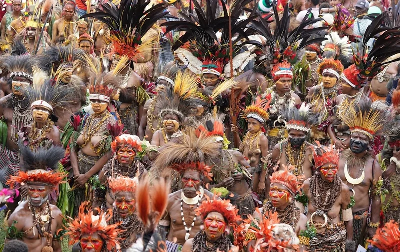
Beyond the physical challenge, the Kokoda Track offers a unique cultural immersion. The trail passes through several remote villages, including Nauro, Menari, Efogi, and Kagi. These communities are the descendants of the legendary "Fuzzy Wuzzy Angels"—the Papuan carriers who provided vital logistical support and evacuated wounded soldiers during the 1942 campaign. Today, the villagers provide a warm welcome to trekkers, offering a glimpse into a way of life that remains largely independent of the modern world. Walking the track is an exercise in humility, as you realise that the heavy pack you carry is but a fraction of the burden borne by those who lived and fought here decades ago.
History and Cultural Context
The historical significance of the Kokoda Track cannot be overstated. In July 1942, Japanese forces landed on the northern coast of Papua with the intent of capturing Port Moresby via an overland advance across the Owen Stanley Range. Port Moresby was a strategic prize; its capture would have provided the Japanese with a base from which to launch air attacks against northern Australia and disrupt vital Allied shipping lanes. What followed was a four-month campaign of brutal jungle warfare that remains a defining chapter in Australian military history.
The initial defence was mounted by the 39th Battalion—a poorly equipped unit of young Australian reservists, many of whom were teenagers. Alongside the Papuan Infantry Battalion, they fought a desperate rearguard action against a battle-hardened Japanese force. The fighting occurred at close quarters in appalling conditions, with malaria, dysentery, and exhaustion claiming as many lives as the combat itself. Key battle sites such as Isurava, Brigade Hill, and Ioribaiwa became synonymous with the virtues of courage, endurance, mateship, and sacrifice. At Isurava, the site of a four-day battle in August 1942, the Australian resistance was so fierce that it is often referred to as "Australia's Thermopylae."
The role of the local Papuan people was instrumental to the Allied survival. Without the "Fuzzy Wuzzy Angels," who carried supplies up the track and carried the "stretcher cases" down, the Australian casualty rate would have been significantly higher. Their compassion and strength earned them a permanent place in the Australian national consciousness. Today, the track is dotted with memorials, plaques, and the remains of wartime equipment—rusted helmets, unexploded ordnance, and aircraft wreckage—that serve as silent witnesses to the conflict. For many trekkers, the journey is a pilgrimage to honour ancestors or to better understand the price of freedom. The land is held in trust by the local landowners, and the Kokoda Track Authority (KTA) works to ensure that the benefits of trekking flow back into these mountain communities, supporting schools, health clinics, and sustainable development.
Want more background? Read extended notes on history and cultural context → Learn more
Seasonal Highlights and Weather Reality
The climate in the Owen Stanley Range is tropical and unpredictable, but it is generally divided into two seasons: the dry season and the wet season. Choosing the right time to trek is critical for safety and success.
The Dry Season (April to September): This is the primary trekking window. While "dry" is a relative term in a rainforest—expect rain at some point almost every day—the precipitation is significantly lower than in the summer months. The track is firmer, river levels are more manageable, and the risk of landslides is reduced. July and August are the peak months, coinciding with the anniversary of the start of the campaign. During this time, the humidity is slightly more bearable, and the views from the high ridges are more likely to be clear of cloud.
The Wet Season (October to March): Trekking during the wet season is strongly discouraged and often impossible. Rainfall can be torrential, turning the track into a river of knee-deep mud and making the steep descents dangerously slippery. Rivers can rise several metres in a matter of hours, washing away temporary bridges and making crossings life-threatening. Furthermore, the cloud cover is often so dense that medical evacuation by helicopter—the only way out in an emergency—becomes impossible. Most reputable tour operators do not run treks during this period.
Regardless of the season, trekkers must be prepared for the "Kokoda Afternoon." Almost like clockwork, the heat of the day builds until mid-afternoon, when a heavy tropical downpour often occurs. This rain can be refreshing, but it quickly makes the terrain more technical. Proper waterproof storage for gear and a high-quality raincoat are essential year-round.
Recommended Itinerary
10-Day Kokoda Track Itinerary (South to North)
Day 1: Owers Corner to Goldie River
- Distance: 4 km
- Elevation: 400 m descent
- Time: 2–3 hours
- Depart Port Moresby for the drive to Owers Corner, the southern trailhead.
- The trek begins with a steep descent to the Goldie River.
- First river crossing (usually thigh-deep).
- Camp at Goldie River or continue to Uberi.
- A short day to test gear and adjust to the humidity.
Day 2: Goldie River to Ioribaiwa
- Distance: 12 km
- Elevation: 800 m gain
- Time: 7–8 hours
- Ascend the "Golden Staircase" (now a steep, muddy slope).
- Pass through the abandoned village of Uberi.
- Climb to the summit of Imita Ridge, the furthest point of the Japanese advance.
- Descend to Ua-Ule Creek for lunch and multiple stream crossings.
- Final steep climb to Ioribaiwa Village for the night.
Day 3: Ioribaiwa to Nauro
- Distance: 10 km
- Elevation: 600 m gain, 700 m descent
- Time: 6–7 hours
- Descend from Ioribaiwa and cross the Maguli Range.
- The track is often extremely muddy in this section.
- Pass through beautiful sections of primary rainforest with giant buttress roots.
- Arrive at Nauro Village, situated on a high plateau with views back toward the coast.
Day 4: Nauro to Menari
- Distance: 9 km
- Elevation: 500 m gain, 600 m descent
- Time: 6–7 hours
- Descend to the Brown River (a major crossing).
- Climb the "Wall" to the top of the Menari Ridge.
- Steep descent into Menari Village.
- Menari is where Lt Col Ralph Honner addressed the 39th Battalion after their withdrawal from Isurava.
Day 5: Menari to Efogi
- Distance: 8 km
- Elevation: 600 m gain
- Time: 5–6 hours
- Climb Brigade Hill (Mission Ridge), the site of a major battle and a moving memorial.
- Spend time at the Brigade Hill summit reflecting on the history.
- Descend into the Efogi valley, the largest village complex on the track.
- Efogi is a great place to interact with locals and visit the small museum.
Day 6: Efogi to Myola (Side Trip)
- Distance: 7 km
- Elevation: 500 m gain
- Time: 4–5 hours
- Climb toward the highest point of the track.
- Divert to Myola, a massive dry lake bed used as a supply drop zone during the war.
- The area is often misty and ethereal, with unique alpine vegetation.
- Camp at Myola or return to the main track at Kagi.
Day 7: Myola to Templeton’s Crossing
- Distance: 10 km
- Elevation: 400 m gain, 600 m descent
- Time: 7–8 hours
- Cross the highest point of the track near Mount Bellamy (2,190 m).
- Enter the "Moss Forest," where trees are draped in thick, damp moss and orchids.
- Descend to Templeton’s Crossing, named after Captain Sam Templeton.
- The track here is rugged and follows the Eora Creek.
Day 8: Templeton’s Crossing to Alola
- Distance: 11 km
- Elevation: 500 m descent
- Time: 7–8 hours
- Follow the Eora Creek downstream.
- Pass through the site of the Eora Creek battle, where Japanese positions were carved into the cliffs.
- Arrive at Alola Village, which offers spectacular views of the valley.
Day 9: Alola to Isurava Memorial
- Distance: 5 km
- Elevation: 200 m gain
- Time: 3–4 hours
- A shorter day to allow for maximum time at the Isurava Memorial.
- The memorial features four granite pillars inscribed with: Courage, Endurance, Mateship, and Sacrifice.
- This is the most sacred site on the track; many groups hold a dawn service here.
Day 10: Isurava to Kokoda
- Distance: 15 km
- Elevation: 1,000 m descent
- Time: 6–7 hours
- A long, knee-jarring descent from the mountains toward the northern plains.
- Pass through Hoi village and into the rubber plantations.
- Walk through the arches at Kokoda Station to finish the trek.
- Visit the Kokoda museum and the war memorial before flying back to Port Moresby.
Important Notes:
- Itineraries can vary from 8 to 12 days depending on fitness and group preference.
- Always allow for a "buffer day" in Port Moresby in case of flight delays from Kokoda.
- River crossings can change daily; follow the guidance of your local porters.
- Hydration is critical; drink at least 4–6 litres of water per day.
Planning and Bookings
Book Your Trip
Everything you need to plan your journey
Accommodation
Find places to stay near Port Moresby
Flights
Search flights to Port Moresby
Essential Preparation
The Kokoda Track is not a walk for the casual hiker. Physical preparation should begin at least 4–6 months before departure. Focus on cardiovascular endurance and leg strength; stair climbing with a weighted pack is the most effective form of training. You must be able to sustain 7–10 hours of physical exertion in high heat and humidity for multiple consecutive days.
Logistically, most trekkers choose to go with an organised tour operator. These companies handle the complex arrangements of charter flights, food logistics, KTA permits, and local porters. When choosing an operator, ensure they are licensed by the Kokoda Track Authority and have a robust safety record, including the carriage of satellite phones and medical evacuation insurance. You will also need a comprehensive medical check-up and a certificate of fitness from your doctor.
Trail Accommodation
Accommodation on the Kokoda Track is basic and rustic. There are no hotels or luxury lodges once you leave Port Moresby. Instead, you will stay in a combination of village guesthouses and designated campsites.
Village Guesthouses: These are typically traditional structures made from bush materials (bamboo walls, thatched roofs) with raised wooden floors. You will sleep on the floor on your own sleeping mat. These guesthouses provide shelter from the rain but offer no insulation or privacy. Most villages have a basic long-drop toilet and a designated washing area in a nearby creek.
Campsites: In areas between villages, such as Templeton’s Crossing or Goldie River, you will stay in cleared campsites. Most tour operators provide tents, though some trekkers prefer to use a hammock with a mosquito net and flysheet. Facilities at these sites are minimal, often consisting of a simple pit toilet and a river for washing.
What is NOT provided: There is no electricity, no mobile phone reception, and no hot water. You must be prepared to live without modern amenities for the duration of the trek. Costs for accommodation are usually included in your tour package, but independent trekkers must pay a small fee (usually 20–50 Kina) directly to the local landowner at each site.
Required Gear
- Trekking Boots: High-quality, waterproof boots with excellent ankle support and aggressive tread. They must be thoroughly broken in before the trek.
- Backpack: A 50–70 litre pack with a high-quality harness. If you hire a personal porter, you will only need a 25–30 litre daypack.
- Gaiters: Essential for keeping mud, stones, and leeches out of your boots.
- Sleeping System: A lightweight sleeping bag (rated to 5°C for the high altitudes), an inflatable sleeping mat, and a small travel pillow.
- Clothing: Moisture-wicking synthetic shirts (merino can be too hot), trekking trousers or shorts, and high-quality wool-blend socks (bring at least 5 pairs).
- Rain Gear: A lightweight, breathable waterproof jacket and a pack cover.
- Headlamp: With spare batteries; nights in the jungle are pitch black.
- Walking Poles: Highly recommended for stability on steep, slippery descents and for testing depth during river crossings.
What to Bring
- Water Treatment: Purification tablets (Micropur) or a high-quality filter (Sawyer Squeeze). While mountain streams look clear, they can carry bacteria from upstream villages.
- Electrolytes: Essential for replacing salts lost through heavy sweating. Bring enough for two doses per day.
- First Aid Kit: Include blister pads (Compeed), antiseptic cream, antifungal powder, rehydration salts, and a broad-spectrum antibiotic (consult your doctor).
- Malaria Prophylaxis: Papua New Guinea is a high-risk malaria zone. You must take preventative medication as prescribed by a travel doctor.
- Personal Hygiene: Biodegradable soap, wet wipes (for "jungle showers"), hand sanitiser, and a quick-dry travel towel.
- Snacks: High-energy trail mix, protein bars, and lollies for a quick sugar boost during steep climbs.
- Sun and Bug Protection: SPF 50+ sunscreen, lip balm, and a tropical-strength insect repellent (DEET 40%+).
Permits
Every trekker on the Kokoda Track is legally required to hold a valid trekking permit issued by the Kokoda Track Authority (KTA). The KTA is the statutory body responsible for managing the track and ensuring that trekking fees are used for the maintenance of the trail and the development of the local communities.
Permit Costs and Acquisition:
- The cost of a permit is currently 350 Kina (approximately AUD$150) for international trekkers.
- If you are trekking with a commercial operator, they will typically handle the permit application process for you, and the cost will be included in your trek fee.
- Independent trekkers must apply for a permit directly through the KTA office in Port Moresby. This requires providing a detailed itinerary, proof of medical insurance (including medevac), and a medical clearance certificate.
- Permits must be carried at all times, as they may be checked by KTA rangers or village leaders along the track.
Insurance Requirements: It is a mandatory condition of the permit that you have travel insurance that specifically covers "trekking up to 3,000 metres" and includes emergency helicopter evacuation. A medical evacuation from the Owen Stanley Range can cost upwards of AUD$15,000–$30,000, and without insurance, helicopters will not be dispatched.
Other Activities in the Area
Most trekkers spend a few days in Port Moresby before or after their journey. While the city has a reputation for being challenging, there are several sites of significant interest:
- Bomana War Cemetery: Located on the outskirts of Port Moresby, this is the largest war cemetery in the South Pacific. It contains the graves of over 3,000 Australian and Allied soldiers. It is a beautifully maintained and deeply moving place to visit after completing the track.
- National Museum and Art Gallery: Offers an excellent introduction to the diverse cultures and history of Papua New Guinea, including impressive displays of traditional masks, canoes, and pottery.
- Port Moresby Nature Park: A well-maintained park where you can see native wildlife, including tree kangaroos, cassowaries, and various species of the Bird of Paradise.
- Adventure Park PNG: Features a small zoo, orchid gardens, and the chance to see the spectacular Raggiana Bird of Paradise display during the early morning.
- Varirata National Park: Located near the start of the track at Owers Corner, this park offers several shorter walking trails and spectacular views over Port Moresby and the coastline.
Safety and Conditions
Health and Tropical Diseases: The greatest threats on the Kokoda Track are not the wildlife, but microscopic pathogens. Malaria is endemic and can be fatal; prophylaxis is non-negotiable. Additionally, the high humidity makes any small scratch or blister prone to rapid infection. Trekkers must practice meticulous wound care, cleaning and dressing even the smallest abrasions immediately. "Jungle rot" (tinea) and heat exhaustion are also common; stay dry where possible and hydrate constantly.
Terrain Hazards: The track is notoriously slippery. The clay soil becomes like grease when wet, and the descent of ridges like the Maguli Range or the descent into Eora Creek can be treacherous. Ankle sprains and knee injuries are the most common reasons for evacuation. Use walking poles and take small, deliberate steps. River crossings should be approached with extreme caution; never attempt to cross a flooded river. Wait for the water to subside, which usually happens within a few hours of the rain stopping.
Environmental Risks: While there are few dangerous large animals, the jungle is home to various snakes (including the Papuan Taipan), though they are rarely seen. More common are leeches and stinging trees (Gympie-Gympie), which can cause intense pain if brushed against. Always follow the lead of your local porters; their knowledge of the flora and fauna is unparalleled.
Communication: There is no mobile coverage on the track. Reputable operators carry satellite phones and VHF radios. If trekking independently, carrying a Personal Locator Beacon (PLB) or a Garmin inReach device is essential for summoning help in a life-threatening emergency.
Side Trips and Points of Interest
Myola Lakes: A detour to Myola is highly recommended. These two large, grass-covered dry lake beds sit at an altitude of about 2,000 metres. During the war, they were a vital drop zone for supplies. Today, they offer a surreal landscape of rolling grasslands surrounded by misty moss forest. It is one of the few places on the track where you can see for more than a few hundred metres.
The Lost Battlefield (Eora Creek): In recent years, historians and local landowners have identified specific sites near Eora Creek where significant Japanese defensive positions were located. Some operators offer guided tours of these "lost" sites, where you can still see foxholes, weapon pits, and discarded equipment hidden in the dense undergrowth.
Kagi and Efogi Village Life: Spending an extra day in one of the larger villages allows for a deeper cultural connection. You can visit the local schools, watch traditional cooking methods (mumu), and hear stories from the elders about their ancestors' experiences during the war. This "slow trekking" approach provides a much richer understanding of the contemporary life of the Oro and Central people.
Mount Bellamy Moss Forest: The section of track near the summit of Mount Bellamy is a botanical wonderland. The "Moss Forest" is a high-altitude cloud forest where every surface is covered in thick, emerald-green moss. It is a silent, dripping world that feels like something out of a prehistoric era.
Leave No Trace
The Kokoda Track is a fragile ecosystem and a sacred historical site. With thousands of trekkers visiting each year, the environmental impact can be significant. It is the responsibility of every trekker to minimise their footprint.
Principles for Kokoda:
- Pack it in, pack it out: Do not leave any rubbish on the track or in the villages. This includes organic waste like fruit peels, which can attract pests. Carry a small "rubbish bag" and dispose of it in Port Moresby.
- Respect the Water: Do not use soap or detergent directly in the rivers or streams. Wash at least 20 metres away from the water source using a collapsible bucket or bottle.
- Stay on the Track: Avoid creating new paths, even if the main track is muddy. This prevents further erosion and protects the surrounding vegetation.
- Cultural Respect: Always ask permission before taking photos of villagers, especially children. Dress modestly when entering villages (keep shirts on).
- Historical Integrity: Do not touch or remove any war relics. It is illegal to take spent cartridges, helmets, or other artefacts out of the country. Leave them where they lie for future generations to see.