Kjeragbolten Hike - Standing on the Edge of the World
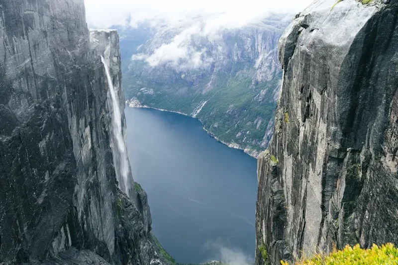
The Kjeragbolten hike is not merely a walk through the Norwegian wilderness; it is a pilgrimage to one of the most recognisable natural wonders on the planet. Located in the heart of the Ryfylke region, high above the emerald waters of the Lysefjord, Kjeragbolten is a five-cubic-metre glacial deposit wedged firmly in a mountain crevice. Suspended 984 metres above the fjord floor, this ancient boulder offers a psychological and physical challenge that draws thousands of adventurers annually. The journey to the "bolt" is an 11-kilometre round trip that demands respect, featuring steep granite climbs, exposed ridges, and some of the most dramatic coastal mountain scenery in Northern Europe. Unlike its famous neighbour, Preikestolen (Pulpit Rock), Kjerag is higher, more rugged, and requires a significantly greater level of physical exertion, rewarding those who persevere with a sense of accomplishment that few other day hikes can match.
- Distance: 11.0 km return
- Duration: 5–6 hours
- Elevation Gain: 800 m
- Difficulty: Challenging / Demanding
- Highest Point: 1,020 m
- Best Time: June to September
- Closest City: Stavanger, Norway
- Trailhead: Øygardstølen (The Eagle's Nest)
Overview
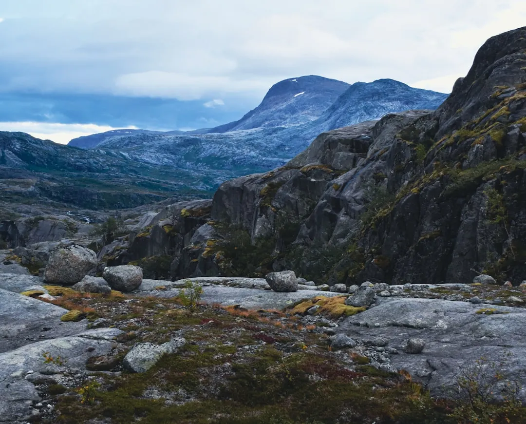
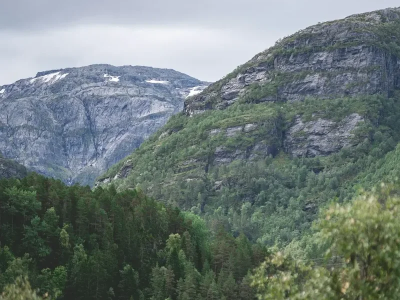
The Kjeragbolten hike is a masterclass in Norwegian mountain terrain. Starting from the Øygardstølen car park—affectionately known as the "Eagle's Nest" due to its precarious position overlooking the Lysebotn road—the trail immediately signals its intentions. This is a landscape of raw, scoured granite, shaped by the immense power of retreating glaciers during the last ice age. The route is characterised by three distinct, steep ascents separated by two shallow valleys, creating a rhythmic "staircase" effect that tests both cardiovascular fitness and leg strength. The terrain is almost entirely rock, which, while providing excellent grip in dry conditions, transforms into a slick, challenging surface when the frequent Norwegian mists descend.
What sets Kjerag apart from other popular Norwegian hikes is the technical nature of the path. To assist hikers on the steepest sections, heavy-duty steel chains have been bolted into the granite. These are essential for pulling oneself up the smooth rock faces and providing stability during the descent. The environment is truly alpine; once you crest the final ridge, the vegetation thins to nothing but hardy mosses and lichens, leaving you on a vast, undulating plateau that feels like the surface of another planet. The climax of the hike is, of course, the boulder itself. Tucked away in a narrow gorge near the Kjerag plateau, the boulder is reached via a small, often slippery ledge. Standing upon it is a rite of passage for many, though the sheer drop into the abyss below ensures that only the most sure-footed (and brave) attempt the feat.
Beyond the boulder, the Kjerag massif is a world-renowned destination for BASE jumpers and mountain climbers. The vertical walls of the fjord drop nearly a kilometre straight into the water, creating a scale of landscape that is difficult to comprehend until you are standing at the edge of the Nesatind viewpoint. The hike is a total immersion in the wild, unforgiving beauty of the Norwegian fjords, offering a stark contrast to the more manicured trails found elsewhere in Europe. It is a place where the weather dictates the terms of the journey, and the reward is a perspective on nature that is both humbling and exhilarating.
History and Cultural Context
The geological history of Kjerag is a story of ice and time. The Lysefjord was carved out by glaciers over several ice ages, with the most recent retreat occurring approximately 10,000 years ago. As the ice melted and the pressure on the land was released, the granite mountains rose in a process known as post-glacial rebound. Kjeragbolten itself is a "glacial erratic"—a piece of rock carried by a glacier and deposited in its current position as the ice melted. It just so happened that this particular boulder became perfectly wedged in a mountain crack, creating the iconic landmark we see today. The name "Kjerag" is thought to be derived from the Old Norse word for a "bolt" or "hook," likely referring to the mountain's jagged profile or the boulder itself.
For centuries, the Kjerag plateau was the domain of local sheep farmers from the village of Lysebotn. The hardy Ryfylke sheep were driven up the steep mountain paths to graze on the high summer pastures. It wasn't until the mid-20th century that the area began to attract recreational hikers and climbers. The real surge in international fame, however, came with the advent of social media and the rise of extreme sports. In the 1990s, Kjerag became a global "Mecca" for BASE jumping. The 1,000-metre vertical drop provides one of the most spectacular exit points in the world. While the hike to the boulder is the primary draw for most visitors, the sight of colourful parachutes drifting down to the fjord below is a common and thrilling part of the modern Kjerag experience.
Culturally, Kjerag represents the Norwegian concept of "Friluftsliv"—a deep-seated philosophy of living in harmony with the outdoors. Norwegians have a "Right to Roam" (Allemannsretten), which allows anyone to access uncultivated land. This freedom comes with a heavy emphasis on personal responsibility and self-reliance. Unlike many tourist destinations where safety railings and paved paths are the norm, Kjerag remains largely wild. The chains are there to assist, but the mountain expects you to be prepared, fit, and respectful of its power. This cultural approach to the wilderness is what keeps the Kjerag experience authentic and challenging.
Want more background? Read extended notes on history and cultural context → Learn more
Seasonal Highlights and Weather Reality
The hiking season for Kjeragbolten is strictly limited by the harsh Nordic winter. The road to the trailhead (FV500) is a high-mountain pass that is typically closed from late October until mid-to-late May due to heavy snow. Attempting the hike outside the official season is highly discouraged and requires professional guiding and specialised winter equipment, as the trail becomes invisible and the risk of avalanches is significant.
Summer (July and August): This is the peak season. The snow has usually melted from the plateau, the days are incredibly long (with nearly 20 hours of daylight in June and July), and the temperatures are at their most favourable, typically ranging from 10°C to 18°C. However, this is also when the trail is most crowded. On a sunny Saturday in August, you may find a queue of people waiting to step onto the boulder. The weather, even in summer, is notoriously fickle. A clear morning in Stavanger does not guarantee a clear day at Kjerag; the fjord can funnel clouds and rain upwards with startling speed.
Shoulder Season (June and September): These months offer a quieter experience but come with increased risks. In June, large snowfields often remain on the trail, particularly in the valleys between the ridges. These can be slippery and may hide meltwater streams beneath. In September, the autumn colours begin to transform the landscape into a tapestry of gold and deep red, but the days shorten rapidly and the first frosts make the granite sections dangerously slick. If you choose to hike in the shoulder season, you must be prepared for temperatures to drop toward freezing, especially if the wind picks up across the exposed plateau.
Weather Reality: The Lysefjord area is one of the wettest regions in Norway. Fog is the most common hazard at Kjerag. When the "sea fog" rolls in from the coast, visibility can drop to less than five metres, making navigation on the featureless plateau extremely difficult. Always check the weather forecast on Yr.no or at the Øygardstølen visitor centre before starting. If the forecast calls for heavy rain or high winds (above 10 m/s), it is wise to postpone the hike. The granite becomes like ice when wet, and the exposed ridges are no place to be in a gale.
Recommended Itinerary
Kjeragbolten Day Hike Itinerary
Early Morning: Arrival and Preparation
- 08:00 – 08:30: Arrive at Øygardstølen car park. Early arrival is essential to secure parking and beat the tour buses.
- Pay the parking fee and use the facilities at the visitor centre.
- Check the latest weather update posted at the trailhead.
- Ensure boots are laced tightly and trekking poles are ready for the first steep climb.
The First Ascent: Øygardstølen to the First Ridge
- Distance: 0 km – 1.5 km
- Elevation Gain: ~150 m
- Time: 45 – 60 minutes
- The hike begins immediately with a steep climb up a smooth granite face.
- Utilise the steel chains provided to pull yourself up the steepest sections.
- This is often considered the most "shocking" part of the hike for those not used to steep terrain.
- Reach the top of the first ridge for a spectacular view back down to the hairpin turns of the Lysebotn road.
The Second Ascent: Storedalen Valley to the Second Ridge
- Distance: 1.5 km – 3.0 km
- Elevation Gain: ~200 m
- Time: 60 minutes
- Descend slightly into the first small valley (Storedalen), which can be boggy or snowy in early summer.
- Begin the second major climb. This section is also assisted by chains and is quite steep.
- The terrain is rugged and requires careful foot placement on the uneven rock.
- Reach the second ridge, where the views of the surrounding Ryfylke mountains begin to open up.
The Final Ascent and the Plateau
- Distance: 3.0 km – 5.0 km
- Elevation Gain: ~300 m
- Time: 60 – 90 minutes
- Descend into the second valley before tackling the longest and final climb.
- This ascent is less technical than the first two but is a long, steady grind up the granite.
- Once you crest the final ridge, the terrain flattens out into the vast Kjerag plateau.
- Follow the red "T" markings painted on the rocks. In fog, stay close to these markers.
- The walk across the plateau is relatively easy but exposed to the wind.
The Boulder and Viewpoints
- Distance: 5.5 km (The Turning Point)
- Time: 30 – 60 minutes at the site
- Follow the signs for "Kjeragbolten" as the trail dips into a narrow, rocky gorge.
- The boulder is wedged at the end of this gorge.
- If you intend to stand on the boulder, wait your turn in the queue. The step onto the rock is narrow and requires a steady head.
- Walk an additional 300 metres to the Nesatind viewpoint for the most dramatic 1,000-metre vertical drop view of the Lysefjord.
- Eat lunch while watching BASE jumpers (if present) or simply soaking in the immense scale of the fjord.
The Return Journey
- Distance: 5.5 km – 11.0 km
- Time: 2.5 – 3 hours
- Retrace your steps across the plateau and down the three ridges.
- The descent can be harder on the knees than the ascent; use the chains to take the weight off your joints.
- Be particularly careful on the smooth granite if it has started to rain.
- Arrive back at Øygardstølen for a well-earned meal at the restaurant.
Important Notes:
- Total time varies significantly based on fitness and weather conditions.
- There are no water sources on the plateau; fill bottles at the streams in the first two valleys.
- The trail is marked with red "T"s, but these can be obscured by snow or fog.
- Always keep the fjord to your left on the way out and to your right on the way back.
Planning and Bookings
Book Your Trip
Everything you need to plan your journey
Accommodation
Find places to stay near Stavanger
Flights
Search flights to Stavanger
Essential Preparation
The Kjeragbolten hike is a serious undertaking that requires a high level of physical fitness. You should be comfortable with steep climbs, using your hands for balance, and walking on uneven, rocky surfaces for several hours. If you have a severe fear of heights, the exposed ridges and the boulder itself may be overwhelming. Preparation begins with choosing your base. Most hikers stay in Stavanger, which is the nearest major city. From Stavanger, you have two main options: a 2.5 to 3-hour drive each way via the RV13 and the spectacular Sirdal mountain road, or a combination of a ferry from Stavanger to Lysebotn followed by a bus or taxi up to Øygardstølen.
If driving, be aware that the final stretch of road from Sirdal to Lysebotn is narrow, winding, and features 27 hairpin turns. It is a beautiful drive but requires concentration. Ensure your vehicle is in good condition and has a full tank of fuel, as there are no petrol stations at the trailhead. If you prefer not to drive, several tour companies in Stavanger offer "Kjerag Express" buses during the summer months, which provide a convenient round-trip service. Booking these in advance is highly recommended, especially in July.
Trail Accommodation
Kjeragbolten is strictly a day hike, and there is no accommodation directly on the trail. Camping is permitted on the plateau under Norway's "Right to Roam" laws, but the environment is extremely exposed, rocky, and often windy, making it suitable only for experienced wild campers with high-quality four-season tents. Most visitors choose one of the following options:
Lysebotn: Located at the base of the mountain, this small village offers a campsite (Lysebotn Camping) and the Lysefjorden Marina, which provides basic rooms and apartments. Staying here allows you to be at the trailhead early in the morning before the crowds arrive from Stavanger. There is also a DNT (Norwegian Trekking Association) cabin, Lysefjorden Turisthytte, which offers dormitory-style beds and meals.
Stavanger: The city has a wide range of accommodation, from budget hostels to luxury hotels. This is the most popular choice for those who want to combine the hike with city amenities, restaurants, and other local attractions.
Sirdal: About 45 minutes from the trailhead, the Sirdal valley has several mountain lodges and cabins (hytter) that are popular in both summer and winter. This is a good middle-ground option if Lysebotn is fully booked.
Required Gear
- Hiking Boots: Sturdy, waterproof boots with excellent ankle support and a high-grip sole (Vibram or similar) are non-negotiable. Trail running shoes are generally not recommended due to the steep granite and potential for ankle rolls.
- Waterproof Shell: A high-quality waterproof and windproof jacket (Gore-Tex or equivalent). Even on a sunny day, the wind on the plateau can be biting.
- Trekking Poles: Highly recommended for the steep descents to protect your knees and provide stability on the uneven rock.
- Layers: A moisture-wicking base layer (merino wool is best), a warm mid-layer (fleece or light down), and hiking trousers (avoid denim, which becomes heavy and cold when wet).
- Backpack: A 20–30 litre daypack with a rain cover.
- Navigation: A physical map and compass, or a reliable GPS app with offline maps (like UT.no or Gaia GPS). Do not rely solely on your phone's battery.
- Headlamp: Even in summer, it is wise to carry a light in case of an injury or delay that keeps you on the mountain after dark.
What to Bring
- Water: At least 2 litres per person. While there are some streams in the lower valleys, the plateau is dry. Water from fast-flowing mountain streams is generally safe to drink in Norway, but a filter is a good precaution.
- High-Energy Food: Pack a substantial lunch plus plenty of snacks (nuts, chocolate, energy bars). You will burn a significant amount of calories on the three climbs.
- Sun Protection: Sunscreen, sunglasses, and a hat. The sun reflects intensely off the granite plateau.
- First Aid Kit: Include blister plasters (Compeed), antiseptic wipes, bandages, and any personal medication.
- Power Bank: To keep your phone charged for photos and emergency calls.
- Trash Bag: To carry out all your waste, including fruit peels and tissues.
- Gloves: Lightweight gloves can be very helpful when gripping the cold steel chains on the ascent and descent.
Permits
One of the great joys of hiking in Norway is the lack of a permit system. There is no fee to hike to Kjeragbolten, and you do not need to register your intent to hike with any authority. This freedom is part of the Norwegian "Allemannsretten" (Right to Roam), which encourages public access to nature. However, this lack of formal regulation means that the responsibility for safety and environmental protection rests entirely on the individual hiker.
Parking Fees: While the trail is free, the parking at Øygardstølen is not. As of 2024, the parking fee for a standard passenger car is approximately 300 NOK (roughly €25–30) per day. This fee goes directly toward the maintenance of the trail, the chains, the visitor centre, and the mountain rescue services. The car park uses an automated camera system (EasyPark), and you can pay via the app or at the machine in the visitor centre. Do not attempt to park along the narrow mountain road; you will be fined and your vehicle may be towed, as it creates a hazard for the tour buses.
Group Sizes and Regulations: There are no official limits on group sizes, but large organised groups are encouraged to coordinate with the Lysefjorden Utvikling (the local management body) to avoid overcrowding. Commercial guides do not need a specific permit to operate on the trail, but they are expected to follow the Norwegian mountain code and ensure their clients are properly equipped.
Drone Regulations: The use of drones is permitted but must follow Norwegian Civil Aviation Authority rules. You must maintain a distance from other hikers, stay below 120 metres, and keep the drone within your line of sight. Be respectful; many people hike to Kjerag for the silence of the mountains, and the buzz of a drone can be highly intrusive.
Other Activities in the Area
The Ryfylke region and the Lysefjord offer a wealth of other adventures that can be combined with your Kjerag hike:
- Preikestolen (Pulpit Rock): The most famous hike in Norway. It is shorter and easier than Kjerag, offering a massive flat plateau with a 604-metre drop. It is located on the opposite side of the fjord.
- Flørli 4444: For those who love a challenge, the village of Flørli (accessible only by ferry) features the world's longest wooden staircase—4,444 steps following an old hydropower pipeline up the mountain.
- Lysefjord Sightseeing Cruise: Take a boat from Stavanger or Forsand to see Kjeragbolten from below. You will also see the "Vagabond's Cave" and the impressive Hengjanefossen waterfall.
- Stavanger Old Town (Gamle Stavanger): After your hike, wander through the best-preserved settlement of wooden houses in Northern Europe, featuring over 170 white-painted cottages from the 18th and 19th centuries.
- The Norwegian Petroleum Museum: A surprisingly fascinating museum in Stavanger that explains the industry that built modern Norway, with excellent interactive exhibits.
- Sola Beach: A beautiful stretch of white sand near Stavanger airport, perfect for a relaxing walk or a (very cold) swim to soothe sore muscles after the hike.
Safety and Conditions
Safety at Kjerag is a matter of personal preparation and respect for the environment. The Norwegian Mountain Rescue (Norsk Folkehjelp) is called out to Kjerag multiple times every year, usually to assist hikers who are ill-equipped, exhausted, or caught in bad weather. To ensure you don't become a statistic, follow these guidelines:
The Chain Sections: The steel chains are there for a reason. Use them. On the descent, many people find it easier to face the rock and climb down backward, or to sit and slide on their bottoms for short sections. Ensure you have a firm grip before moving your feet. If you are hiking with children, they may need assistance as the chain height is designed for adults.
Fog and Navigation: Fog is the greatest danger at Kjerag. The plateau is a vast expanse of grey rock with few natural landmarks. If the fog rolls in, the red "T" markers can become impossible to see. If you lose the trail, do not wander. Use your GPS to retrace your steps to the last known marker. If you are completely lost and visibility is zero, it is often safer to find a sheltered spot and wait for the fog to lift than to risk walking off the edge of the fjord.
The Boulder: Standing on Kjeragbolten is entirely at your own risk. There are no safety ropes or nets. The ledge leading to the boulder is narrow and can be slippery if wet or sandy. If you feel dizzy, nervous, or if the wind is gusting, do not attempt it. The view from the Nesatind viewpoint is just as spectacular and far safer. Never jump or perform stunts on the boulder; a slip is fatal.
Hypothermia: Even in summer, the temperature on the plateau can be 10 degrees lower than in Stavanger, and the wind chill can be significant. If you get wet and the wind picks up, hypothermia can set in quickly. Always carry a dry spare layer and a waterproof shell.
Emergency Contact: The emergency number in Norway is 112. Mobile signal is generally good on the plateau but can be non-existent in the valleys between the ridges. If you need help, try to reach a high point to get a signal.
Side Trips and Points of Interest
While the boulder is the main event, there are several other points of interest along the Kjerag massif that are worth the extra steps:
Nesatind: This is the viewpoint located just a few hundred metres past the boulder. It offers the most direct view down the vertical wall of the Kjerag massif. It is from here that you truly appreciate the 1,000-metre drop. It is also the primary exit point for BASE jumpers; if you are lucky, you might see them preparing for their leap.
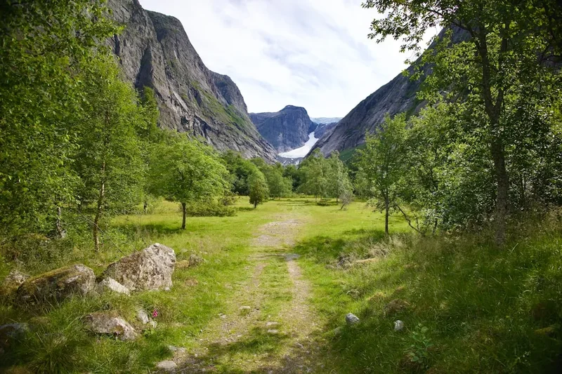
Kjeragfossen: This is one of the highest waterfalls in the world, with a total drop of 715 metres. It is a "seasonal" waterfall, meaning it is most impressive in late spring and early summer during the snowmelt. The trail passes near the top of the falls, and the sight of the water atomising into mist before it even reaches the fjord is mesmerising.
The "Lighthouse" Cairn: On the highest point of the plateau (1,020 m), there is a massive stone cairn. While the trail doesn't go directly over the summit, a short detour offers a 360-degree panorama of the Ryfylke highlands, stretching all the way to the Hardangervidda plateau on a clear day.
Hidden Valleys: If you have extra time and energy, exploring the small valleys (like Storedalen) can reveal hidden alpine flowers and small, crystal-clear tarns that are perfect for a quick, refreshing (and freezing) dip.
Leave No Trace
The Kjerag plateau is a fragile alpine environment. Because it is mostly rock, it may seem indestructible, but the thin soils and mosses that cling to the crevices are easily damaged and take decades to recover. With over 80,000 visitors a year, the cumulative impact can be devastating if we do not follow Leave No Trace principles.
- Stick to the Trail: Follow the red "T" markings. Avoid creating "social trails" or shortcuts, which lead to erosion and confuse other hikers.
- Pack It In, Pack It Out: This includes everything. There are no bins on the trail. Even biodegradable items like banana peels and apple cores should be taken back to the visitor centre, as they do not decompose quickly in the cold alpine climate and can attract scavengers.
- Respect Wildlife: You may see sheep or the occasional reindeer. Keep your distance and never feed them. Dogs must be kept on a leash at all times (this is a legal requirement in Norway from April to September to protect grazing animals and nesting birds).
- Toilet Etiquette: Use the toilets at Øygardstølen before you start. If you are caught short on the trail, move at least 50 metres away from any water sources and the trail. Bury waste in a "cathole" if possible, or better yet, use a "wag bag" and carry it out. Never leave toilet paper on the mountain.
- Leave What You Find: Do not build new stone cairns. While they may look "zen," they can mislead hikers in the fog and disturb the natural aesthetic of the landscape.