Kings Canyon Rim Walk - The Crown of the Red Centre
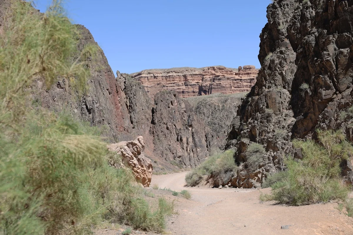
The Kings Canyon Rim Walk is arguably Australia’s most spectacular desert day hike, a 6-kilometre circuit that traverses the high ridges of Watarrka National Park in the Northern Territory. Located approximately midway between Alice Springs and Uluru, this trail offers a profound encounter with the ancient geological heart of the continent. Unlike the flat, expansive plains that characterise much of the Red Centre, Kings Canyon presents a vertical world of 100-metre-high sandstone walls, deep shaded chasms, and hidden permanent waterholes that support life found nowhere else in the surrounding desert. The walk is famous for its dramatic "Heartbreak Hill" ascent, the weathered sandstone domes of the "Lost City," and the lush, prehistoric oasis known as the "Garden of Eden." It is a journey through 440 million years of Earth’s history, where the vibrant ochre of the rock contrasts sharply with the brilliant blue of the desert sky and the resilient green of ancient cycads.
- Distance: 6.0 km loop
- Duration: 3–4 hours
- Season: May to September (best conditions); summer walking restricted by heat
- Elevation Gain: 200 m (mostly in the initial ascent)
- Difficulty: Moderate (requires good fitness for the initial steep climb)
- Highest Point: Approximately 730 m above sea level
- Trailhead: Kings Canyon Car Park, Watarrka National Park
- Access: Sealed road from Yulara (300 km) or Alice Springs (320 km via Luritja Road)
Overview
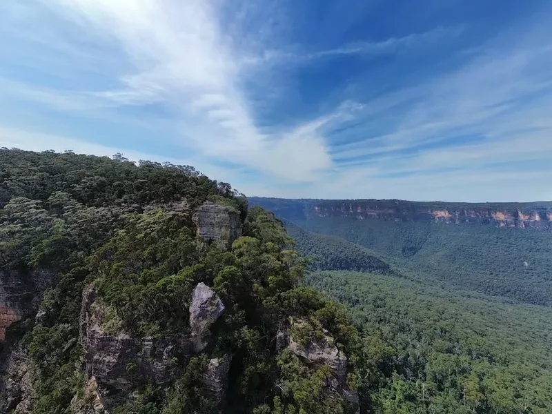
The Kings Canyon Rim Walk is the signature experience of Watarrka National Park, a landscape defined by the sheer scale of its erosion and the resilience of its ecology. While the Red Centre is often associated with the monolithic presence of Uluru, Kings Canyon offers a different kind of majesty—one of intricate detail, verticality, and hidden sanctuaries. The walk begins with a challenging ascent, colloquially known as "Heartbreak Hill," which brings hikers from the canyon floor to the summit of the rim. From this vantage point, the true scale of the canyon is revealed: a massive fissure in the George Gill Range, carved over millions of years by wind and water.
The geology of the canyon is a primary draw. The upper layers are composed of Mereenie Sandstone, which has weathered into the distinctive beehive-shaped domes of the "Lost City." These formations resemble the ruins of an ancient civilisation, creating a labyrinthine landscape that walkers navigate as they move along the northern rim. Beneath the Mereenie Sandstone lies the softer Carmichael Sandstone, which erodes more quickly, leading to the dramatic undercutting that creates the canyon’s vertical walls. The colour palette is quintessentially Australian: deep oranges, burnt reds, and pale creams, all shifting in intensity as the sun moves across the sky.
Perhaps the most surprising element of the Rim Walk is the "Garden of Eden." Located in a deep cleft in the rock, this permanent waterhole is surrounded by lush vegetation, including the MacDonnell Ranges Cycad (*Macrozamia macdonnellii*), a "living fossil" that has survived here since a time when Central Australia was a much wetter, tropical environment. This contrast between the arid, sun-baked rim and the cool, verdant depths of the canyon floor provides a masterclass in desert microclimates. The walk is not merely a physical challenge but a sensory immersion into a landscape that feels both timeless and fragile.
Due to the extreme temperatures of the Australian Outback, the Rim Walk is subject to strict safety regulations. During the summer months, the walk must be started before 9:00 AM to avoid the peak heat of the day. Even in the cooler months, the intensity of the sun and the lack of shade on the rim require careful preparation. However, for those who make the effort, the reward is a panoramic view of the desert that stretches to the horizon, punctuated by the flight of Peregrine Falcons and the quiet rustle of the wind through the Ghost Gums.
History and Cultural Context
The land encompassing Kings Canyon and the George Gill Range is the traditional country of the Luritja people, who have lived in and cared for this region for tens of thousands of years. To the Luritja, this area is known as Watarrka, named after the umbrella bush (*Acacia ligulata*) that is common in the landscape. The canyon is a place of immense spiritual significance, containing numerous sacred sites and being a vital source of water and food in an otherwise harsh environment. The permanent waterholes within the canyon were essential stopping points on ancient songlines and trade routes that crisscrossed the continent.
European exploration of the region began in the late 19th century. Ernest Giles was the first European to sight the George Gill Range in 1872, naming it after his brother-in-law. Giles was struck by the beauty and the "romantic" nature of the canyon, though he did not explore the rim itself. It wasn't until the mid-20th century that the area became more widely known to the outside world. In the 1960s, Jack Cotterill, a pioneer of Central Australian tourism, recognised the potential of Kings Canyon and began bringing small groups of adventurous travellers to the site. He established a basic camp and helped forge the initial tracks that would eventually become the modern Rim Walk. The lookout on the south rim is named in his honour, recognising his role in opening the canyon to the world.
Watarrka National Park was formally established in 1986, and today it is managed through a joint partnership between the Northern Territory Government and the Luritja traditional owners. This joint management ensures that the cultural values of the land are protected while allowing visitors to experience its natural wonders. Hikers are reminded that they are walking through a living cultural landscape; many areas off the main track are restricted to protect sacred sites and the privacy of the traditional owners. The history of Kings Canyon is a tapestry of ancient indigenous connection, colonial exploration, and modern conservation, all of which contribute to the profound sense of place felt by those who walk its rim.
Want more background? Read extended notes on history and cultural context → Learn more
Seasonal Highlights and Weather Reality
The climate of the Red Centre is one of extremes, and your experience of the Kings Canyon Rim Walk will be entirely dictated by the time of year you visit. There are essentially two seasons: the cool, dry winter and the hot, occasionally wet summer.
Winter (May to September): This is the peak trekking season and the most comfortable time to complete the Rim Walk. Daytime temperatures typically range from 18°C to 25°C, with clear blue skies and low humidity. These conditions are ideal for the strenuous "Heartbreak Hill" ascent. However, nights can be freezing, with temperatures often dropping below 0°C, so those staying at nearby campsites should be prepared for cold mornings. The light during winter is exceptionally crisp, making it the best time for photography, particularly at sunrise and sunset when the sandstone glows with a deep, saturated red.
Shoulder Seasons (April and October): These months can be unpredictable. You may experience perfect walking weather or sudden heatwaves where temperatures soar above 35°C. If visiting during these months, it is essential to start the walk as early as possible (at first light) to finish before the midday heat becomes dangerous.
Summer (November to March): Summer in the Red Centre is characterised by intense heat, with daily maximums frequently exceeding 40°C. The Rim Walk is subject to a "Heat Gate" policy: if the forecast temperature is 36°C or higher, walkers must start the Rim Walk before 9:00 AM. After this time, the entrance to the Rim Walk is closed for safety reasons. Walking in these conditions carries a high risk of heat exhaustion and heatstroke. While summer can bring spectacular afternoon thunderstorms and the rare sight of water cascading off the canyon walls, it is generally not recommended for recreational hiking unless you are extremely well-prepared and start at dawn.
Regardless of the season, the UV index in Central Australia is almost always "Extreme." Even on a cool winter day, the sun can burn skin within minutes. Rain is infrequent but can be heavy when it occurs, occasionally causing temporary closures of the Garden of Eden section due to flash flooding or slippery rock surfaces.
Recommended Itinerary
Kings Canyon Rim Walk Route Progression
Stage 1: The Ascent (Heartbreak Hill)
- Distance: 0.5 km
- Elevation gain: 150 m
- Time: 20–30 minutes
- The walk begins immediately with the most strenuous section: a steep climb up natural stone stairs.
- Known as "Heartbreak Hill," this section requires a moderate level of fitness and frequent pauses to catch your breath.
- As you climb, look back for views of the canyon floor and the distant George Gill Range.
- The ascent ends at the top of the northern rim, where the terrain flattens out significantly.
Stage 2: The North Rim and Priscilla's Crack
- Distance: 1.5 km
- Time: 45 minutes
- Once on the rim, the path winds through weathered sandstone formations.
- Pass through "Priscilla's Crack," a narrow split in the rock made famous by the film 'The Adventures of Priscilla, Queen of the Desert'.
- The trail follows the edge of the northern wall, offering the first dramatic views down into the 100-metre abyss.
- Look for the white-barked Ghost Gums clinging to the cliff edges.
Stage 3: The Lost City
- Distance: 1.0 km
- Time: 30 minutes
- The trail enters an area of rounded sandstone domes that resemble an ancient, abandoned city.
- This is a geological highlight, showing the effects of millions of years of wind erosion on the Mereenie Sandstone.
- The path is relatively flat here but requires careful foot placement on the uneven rock surfaces.
- This is an excellent area for spotting the Black-flanked Rock-wallaby in the shadows of the domes.
Stage 4: Cotterill's Lookout (Optional Detour)
- Distance: 0.6 km return
- Time: 20 minutes
- A well-marked side trip leads to a spectacular viewpoint on the very edge of the canyon.
- Provides the best perspective of the sheer verticality of the opposite (southern) wall.
- Named after Jack Cotterill, the tourism pioneer of the region.
Stage 5: The Garden of Eden
- Distance: 1.0 km (including descent into the chasm)
- Time: 45–60 minutes
- The trail descends via a series of wooden stairs and bridges into a deep, shaded cleft between the north and south rims.
- This is a permanent waterhole and a sacred site for the Luritja people.
- The temperature drops noticeably here, and the vegetation becomes lush and green.
- Observe the ancient cycads and listen for the calls of honeyeaters and finches.
- Note: Swimming is strictly prohibited to protect the fragile ecosystem and respect cultural values.
Stage 6: The South Rim and Descent
- Distance: 1.4 km
- Time: 40 minutes
- After climbing back out of the Garden of Eden, the trail traverses the southern rim.
- This section offers the best views of the "North Wall," which is often illuminated in brilliant orange light in the late morning.
- The path eventually begins a gradual descent through a series of switchbacks and stone steps.
- The walk concludes back at the Kings Canyon Car Park.
Important Notes:
- The walk is one-way (clockwise) to manage traffic and safety.
- There is no water available on the trail; you must carry all you need from the trailhead.
- Emergency call devices are located at several points along the rim.
- Stay well back from the cliff edges, as the sandstone can be unstable.
Planning and Bookings
Book Your Trip
Everything you need to plan your journey
Accommodation
Find places to stay near Yulara or Alice Springs
Flights
Search flights to Yulara or Alice Springs
Essential Preparation
Planning for Kings Canyon requires a focus on logistics and physical readiness. The canyon is remote, located several hours from the nearest major towns. Most visitors base themselves at either the Kings Canyon Resort or Kings Creek Station, both of which are within a short drive of the trailhead. If you are travelling from Alice Springs or Uluru, ensure your vehicle is in good condition and you have a full tank of fuel; while the roads are sealed, the distances are vast and services are limited.
Fitness is a key consideration. While the majority of the 6-kilometre walk is at a moderate gradient, the initial 500-metre ascent is very steep and can be taxing in the heat. Ensure you have "broken in" your hiking boots before arrival, as the sandstone surfaces are uneven and can be abrasive. There is no mobile phone reception on most of the trail, so downloading offline maps or carrying a physical description is recommended, although the track is very well-marked with blue triangular markers.
Trail Accommodation
The Kings Canyon Rim Walk is a day hike, and there is no accommodation or camping allowed on the trail itself or within the canyon. However, there are several options nearby for overnight stays:
Kings Canyon Resort:
- Located 7 km from the trailhead.
- Offers a range of accommodation from luxury hotel rooms to "Glamping" tents and standard lodge rooms.
- Includes a large campground with powered and unpowered sites for caravans and tents.
- Facilities: Petrol station, general store, restaurants, bar, and swimming pool.
- Booking: Highly recommended, especially during the peak winter months (May–September).
Kings Creek Station:
- Located 36 km from the trailhead.
- A working cattle and camel station offering a more "outback" experience.
- Accommodation: Safari tents, bush tents, and a campground.
- Facilities: Café (famous for camel burgers), basic supplies, and fuel.
- Booking: Recommended for tent stays; camping sites usually have more availability.
Wild Camping: There is no free or wild camping permitted within Watarrka National Park. Visitors must use the designated commercial sites mentioned above to protect the environment and respect the traditional owners.
Required Gear
- Hiking Boots or Sturdy Shoes: Must have good grip for sandstone surfaces and ankle support for the uneven terrain of the "Lost City."
- Sun Protection: A wide-brimmed hat (not just a cap), high-SPF sunscreen, and UV-rated sunglasses are non-negotiable.
- Clothing: Lightweight, breathable, and light-coloured clothing. Long sleeves are recommended for sun protection. In winter, bring a warm jacket for the pre-dawn start.
- Day Pack: A 15–25L pack with a comfortable harness to carry water and supplies.
- Navigation: While the trail is well-marked, a printed map or an offline GPS app (like AllTrails or Gaia) is useful for identifying landmarks.
- First Aid Kit: Include blister pads, antiseptic cream, and a compression bandage (for potential snake bites, though rare).
What to Bring
- Water: Minimum 3 litres per person. In temperatures over 30°C, 4 litres is recommended. There are no refill points on the rim.
- Electrolytes: Powder or tablets to add to your water to prevent dehydration and cramping.
- High-Energy Snacks: Trail mix, fruit, energy bars, and salty snacks to replenish salts lost through sweat.
- Rubbish Bags: To carry out all waste, including fruit peels and tissues.
- Camera/Smartphone: For the incredible vistas, but ensure they are fully charged.
- Personal Medications: Especially if you have asthma or allergies, as the dry air and dust can be triggers.
- Fly Net: During the warmer months, the "Aussie Salute" becomes mandatory as bush flies can be persistent. A head net is a small but life-saving investment.
Permits
As of 2023, all visitors to Northern Territory National Parks, including Watarrka National Park, require a NT Parks Pass. This pass is essential for all non-residents of the Northern Territory and must be purchased online before you arrive at the park.
Pass Options and Costs:
- Day Pass: Approximately $10.00 per person (valid for one day).
- 2-Week Pass: Approximately $30.00 per person (ideal for those visiting Uluru-Kata Tjuta and the West MacDonnell Ranges as well).
- Open Pass: Approximately $60.00 per person (valid for 12 months).
- Children under 16 are generally free, but check the official NT Parks website for the most current pricing.
How to Purchase: Passes must be booked via the Northern Territory Government's online booking portal. It is highly recommended to do this in Alice Springs or Yulara before heading to the canyon, as mobile reception at the park entrance is unreliable and cannot be guaranteed for processing payments.
Other Regulations:
- No Separate Walking Permit: Unlike the Larapinta Trail, there is no specific permit required just to walk the Rim Walk, provided you have your NT Parks Pass.
- Commercial Filming/Photography: If you are planning to use a drone or conduct commercial photography, you must apply for a separate permit well in advance. Drone use by recreational visitors is strictly prohibited in Watarrka National Park to protect the privacy of traditional owners and the nesting sites of birds of prey.
- Group Sizes: Large organised groups (over 15 people) should notify the park rangers in advance to ensure they do not clash with maintenance or cultural activities.
Other Activities in the Area
While the Rim Walk is the main attraction, Watarrka National Park and its surrounds offer several other ways to experience the Red Centre:
- Kings Canyon Scenic Flights: Helicopter tours depart from near the Kings Canyon Resort and Kings Creek Station. This is the only way to truly appreciate the "Lost City" domes and the vastness of the George Gill Range from above.
- Karrke Aboriginal Cultural Experience: Located a short drive from the canyon, this indigenous-owned tour provides deep insights into Luritja culture, including bush medicine, traditional dot painting, and the importance of the "Bush Tucker" found in the region.
- Kings Creek Hike: For those who prefer a less strenuous option, this 2.6 km return walk follows the canyon floor. It leads to a lookout point with views up at the towering canyon walls and is suitable for families and those with limited mobility.
- Kathleen Springs Walk: Located 21 km from Kings Canyon, this easy 2.4 km paved walk leads to a permanent spring and a historic stockyard. It is a peaceful spot for birdwatching and learning about the area's pastoral history.
- Under a Desert Moon: A signature dining experience at Kings Canyon Resort, offering a multi-course meal under the stars, featuring Australian bush ingredients.
- Giles Track: For experienced hikers, this 22 km overnight trek connects Kings Canyon with Kathleen Springs, traversing the top of the range with spectacular wilderness camping.
Safety and Conditions
Heat Management: Heat is the single greatest danger at Kings Canyon. The sandstone rim acts as a heat sink, radiating warmth long after the sun has moved. Dehydration and heatstroke can occur rapidly. Always follow the "Heat Gate" signs; if the gate is closed, do not attempt to bypass it. Drink small amounts of water frequently rather than large amounts occasionally. If you begin to feel dizzy, nauseous, or stop sweating, seek shade immediately and use an emergency call device if necessary.
Cliff Edges: The canyon walls are spectacular but can be unstable. The Mereenie Sandstone is prone to "sheeting," where large sections of the cliff face can break away without warning. There are no fences along most of the rim to preserve the natural beauty. Always stay at least two metres back from the edge, and never lean over to take photographs. Supervise children strictly at all times.
Wildlife Encounters: While most animals in the park are harmless, Central Australia is home to several species of venomous snakes, including the King Brown and the Western Brown. Snakes are generally shy and will move away if they hear you coming. Wear sturdy boots and gaiters if walking off-track (though off-track walking is discouraged). If you encounter a snake, stop, remain calm, and allow it to move away. Do not attempt to touch or kill it.
Emergency Procedures: There are several Emergency Satellite Call Points located along the Rim Walk (marked on trail maps). These connect directly to the park rangers. In the event of a serious injury, stay with the person and send someone to the nearest call point. Because of the vertical terrain, helicopter rescues are often the only way to evacuate injured hikers from the rim, which is a costly and complex operation. Ensure you have high-quality travel insurance that covers remote medical evacuation.
Water Quality: The water in the Garden of Eden and other rock pools is untreated and may contain harmful bacteria or parasites. It is also a vital resource for local wildlife and holds deep cultural significance. Do not drink the water, do not swim in it, and do not use soaps or detergents near the waterholes.
Side Trips and Points of Interest
The Garden of Eden: This is the emotional heart of the walk. The descent into the cool, shaded chasm feels like entering another world. The permanent water is surrounded by Ghost Gums and ancient cycads. It is a place for quiet reflection. Please respect the "No Swimming" signs, as the oils and sunscreens from human skin can devastate the fragile aquatic ecosystem that has existed here for millennia.
Priscilla's Crack: A narrow, vertical split in the sandstone that the trail passes through. It provides a fantastic "frame" for photographs of the canyon rim and is a fun geological feature to navigate. It gained international fame through its appearance in the 1994 film 'The Adventures of Priscilla, Queen of the Desert'.
The Lost City Domes: These formations are a result of "vertical jointing" in the sandstone. Over millions of years, water has seeped into cracks, freezing and expanding (in the distant past) or simply eroding the rock into the rounded, beehive shapes seen today. Walking through them feels like navigating a natural labyrinth.
Black-flanked Rock-wallaby Spotting: These endangered marsupials are often seen on the shaded ledges of the canyon walls, particularly in the early morning or late afternoon. They are incredibly agile, leaping across seemingly impossible gaps in the rock. Look for movement among the shadows and the distinctive white stripe on their cheeks.
Weathered Ripple Marks: Look closely at the sandstone surfaces on the rim. In many places, you can see fossilised ripple marks, identical to those you would see on a modern beach. These are 440-million-year-old imprints from a time when this entire region was a shallow inland sea, providing a tangible link to the deep history of the Australian continent.
Leave No Trace
Watarrka National Park is a fragile desert environment and a place of profound cultural importance. Every visitor has a responsibility to minimise their impact to ensure the canyon remains pristine for the Luritja people and future generations of walkers.
Leave No Trace Principles for Kings Canyon:
- Stay on the Marked Track: The desert crust (cryptogamic soil) is a living layer of lichens, mosses, and fungi that prevents erosion and fixes nitrogen in the soil. A single footstep can destroy decades of growth. Always stay on the hard rock or the defined path.
- Carry Out All Waste: This includes "organic" waste like orange peels, apple cores, and sunflower seeds. In the arid desert environment, these items do not decompose quickly and can attract invasive species or harm native wildlife.
- Respect Sacred Sites: Many areas within the canyon are culturally sensitive. If a sign asks you not to enter an area or not to take photographs, please comply without question.
- No Drones: Drones disturb the peace of other walkers, interfere with sacred sites, and can cause nesting birds of prey (like the Peregrine Falcon) to abandon their chicks.
- Do Not Touch Rock Art: If you happen to see any indigenous rock art, do not touch it. The oils from your skin cause the pigments to degrade.
- Use Toilets Provided: Use the facilities at the car park before you start. If you are caught short on the trail, ensure you are at least 100 metres from any water source and bury waste at least 15 cm deep, carrying out all toilet paper in a sealed bag.
By following these principles, you help preserve the "Garden of Eden" and the "Lost City" as the wild, spiritual places they have been for thousands of years.