
Kilimanjaro Umbwe Route - The Vertical Path to the Roof of Africa
The Umbwe Route is widely recognised as the most challenging, shortest, and most direct path to the summit of Mount Kilimanjaro. While other routes like the Machame or Lemosho meander through the mountain's various flanks to allow for gradual acclimatisation, the Umbwe Route strikes a defiant line straight up the southern slopes. This is a journey designed for the experienced trekker—those who possess not only physical stamina but also the mental fortitude to tackle steep ridges and rapid altitude gain. Spanning approximately 37.0 kilometres with a staggering elevation gain of 4,000 metres, the Umbwe Route is often referred to as the "Double Whiskey" route, a nod to its reputation for being significantly tougher than the popular "Whiskey Route" (Machame).
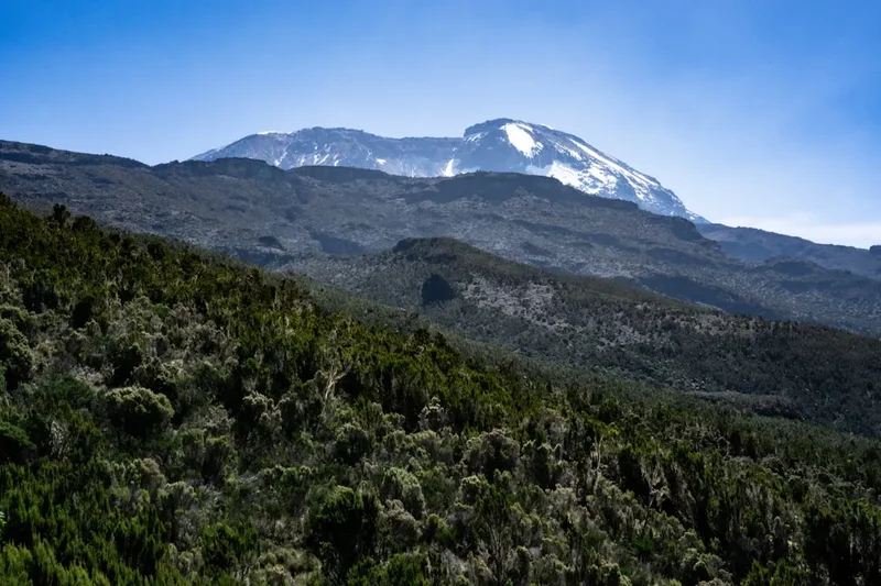
Starting at the Umbwe Gate at 1,600 metres, the trail pierces through dense, montane rainforest before emerging onto narrow, dramatic ridges that offer some of the most spectacular views on the mountain. Unlike the more crowded eastern and northern approaches, Umbwe offers a profound sense of solitude and raw wilderness. It is a route of extremes: from the humid, moss-draped forests of the lower reaches to the sub-zero, oxygen-depleted arctic desert of the summit crater. For those who choose this path, the reward is a visceral connection with the mountain's verticality and a quiet, intense approach to Uhuru Peak, the highest point in Africa at 5,895 metres.
- Distance: 37.0 km total (ascent and descent)
- Duration: 5–6 days
- Difficulty: Very Challenging (steepest and most direct route)
- Elevation Gain: 4,000 m
- Highest Point: Uhuru Peak (5,895 m)
- Best Time: June to October and January to February
- Closest City: Moshi, Tanzania
Overview
Mount Kilimanjaro, a dormant stratovolcano in north-eastern Tanzania, is the tallest free-standing mountain in the world. Among the seven primary trekking routes that lead to its summit, the Umbwe Route stands apart as the "climber's route." It is characterised by its relentless incline and the speed at which it traverses the mountain's ecological zones. Because the route ascends so quickly, it provides very little opportunity for the body to naturally acclimatise to the thinning air, making it the route with the lowest success rate for those who are not already pre-acclimatised or exceptionally fit.
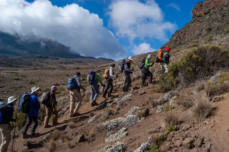
The journey begins in the Cultivation Zone, where the fertile volcanic soil supports lush shambas (farms) and coffee plantations. However, the trek officially starts at the Umbwe Gate, entering the Rainforest Zone. Here, the trail is often muddy and slick, winding through ancient trees draped in "old man's beard" lichen. As the trail climbs, the forest thins into the Heath and Moorland Zone. This is where the Umbwe Route truly reveals its character; the path follows a narrow ridge between the Lonzo and Umbwe rivers. The drops on either side are dramatic, and the views of the southern ice fields of Kilimanjaro are unparalleled.
By the second or third day, the Umbwe Route joins the more popular Southern Circuit near Barranco Camp. From this point forward, trekkers face the famous Barranco Wall—a 257-metre scramble that requires the use of hands and feet—before crossing the alpine desert towards the final base camp at Barafu. The final push to the summit is a test of pure will, conducted in the dark of night to reach Uhuru Peak at sunrise. The descent is typically managed via the Mweka Route, a fast-track down the mountain that protects the knees while providing a quick return to the lush greenery of the lower slopes. The Umbwe Route is not merely a hike; it is a high-altitude endurance test that demands respect for the mountain's power and an understanding of one's own physical limits.
History and Cultural Context
The history of Mount Kilimanjaro is inextricably linked to the Chagga people, who have lived on its lower slopes for centuries. To the Chagga, the mountain—specifically the snow-capped Kibo peak—was a sacred entity, often associated with the divine. While they did not traditionally climb to the summit, their knowledge of the forests and water sources was essential for early European explorers. The name "Kilimanjaro" itself has debated origins, with some suggesting it comes from the Chagga word "Kilemanjaare," meaning "that which defeats the bird," or the Swahili "Kilima Kyaro," meaning "Mountain of Caravans."
The first recorded ascent of Kilimanjaro was achieved in 1889 by German geographer Hans Meyer and Austrian mountaineer Ludwig Purtscheller, guided by a local Chagga scout named Yohani Kinyala Lauwo. In those early days of exploration, there were no established "routes" as we know them today. Explorers pushed through dense bush and over glaciers that have since retreated significantly. The Umbwe Route was developed much later as a more direct, technical alternative to the Marangu (the oldest route) and the Machame. It was originally favoured by professional climbers and those looking to test their speed on the mountain.
In the mid-20th century, the Umbwe Route gained a reputation as the "Breach Wall" approach. Before the glaciers receded to their current state, climbers would use the Umbwe Route to access the Western Breach and the Great Barranco, often involving technical ice climbing. Today, while the glaciers have shrunk and the Western Breach is frequently closed due to rockfall risks, the Umbwe Route remains the preferred choice for those seeking the most "alpine" experience possible on Kilimanjaro. It serves as a reminder of the mountain's rugged history, offering a path that feels less like a tourist trail and more like a true mountain expedition.
Want more background? Read extended notes on history and cultural context → Learn more
Seasonal Highlights and Weather Reality
Kilimanjaro's proximity to the equator means it does not experience traditional four-season cycles. Instead, the weather is dictated by the movement of the Intertropical Convergence Zone, resulting in two distinct wet seasons and two dry seasons. Choosing the right window is critical for the Umbwe Route, as the steep ridges and muddy forest paths become significantly more dangerous in the rain.
The Long Dry Season (June to October): This is widely considered the best time to tackle the Umbwe Route. The skies are generally clear, providing the best views of the glaciers and the plains below. While it is the "winter" in the southern hemisphere, meaning temperatures at night can drop well below freezing, the stability of the weather makes the steep ascent much safer. The dust on the upper reaches can be a challenge, but the lack of mud in the rainforest is a major advantage.
The Short Dry Season (January to February): Another excellent window, often slightly warmer than the June–October period. This is a popular time for summit attempts, as the weather is predictable and the clarity of the air is exceptional. However, it can be busier on the mountain, though the Umbwe Route itself remains relatively quiet compared to others.
The Wet Seasons (April to May and November): Trekking the Umbwe Route during the "long rains" of April and May is strongly discouraged. The rainforest section becomes a vertical mudslide, and visibility on the ridges is often zero. Snowfall on the summit can be heavy, making the final scramble treacherous. The "short rains" in November are less intense but can still make for a miserable and dangerous experience on such a steep trail. The risk of hypothermia increases dramatically when gear becomes wet in the high-altitude cold.
Recommended Itinerary
6-Day Kilimanjaro Umbwe Route Itinerary
Day 1: Umbwe Gate to Umbwe Cave Camp
- Distance: 11 km
- Elevation: 1,600 m to 2,850 m
- Time: 5–7 hours
- Register at the Umbwe Gate and meet the support crew
- Begin the ascent through the dense montane rainforest
- The trail is immediately steep, winding through ancient trees and thick undergrowth
- Listen for the calls of Blue Monkeys and Colobus Monkeys in the canopy
- Arrive at Umbwe Cave Camp, situated in a clearing within the upper forest zone
- First night under canvas; the air begins to cool significantly as the sun sets
Day 2: Umbwe Cave Camp to Barranco Camp
- Distance: 6 km
- Elevation: 2,850 m to 3,900 m
- Time: 4–5 hours
- Leave the forest behind as the trail enters the Heath and Moorland zone
- The path follows the narrow "Umbwe Ridge," with steep drops into the valleys on either side
- First clear views of the Kibo Peak and the southern glaciers
- The vegetation shifts to hardy shrubs and the iconic Giant Senecios
- The trail levels out slightly as it approaches the Great Barranco Valley
- Arrive at Barranco Camp, one of the most scenic campsites on the mountain, nestled beneath the Great Barranco Wall
Day 3: Barranco Camp to Karanga Camp
- Distance: 5 km
- Elevation: 3,900 m to 3,995 m
- Time: 4–5 hours
- Begin the day by tackling the Great Barranco Wall—a non-technical but exhilarating scramble
- Reach the top of the wall for spectacular views of the Heim Glacier
- The trail then traverses a series of hills and valleys (the "ups and downs" of the Southern Circuit)
- Cross the Karanga Valley, the last water source on the approach
- Arrive at Karanga Camp for lunch and an afternoon of rest
- This shorter day is crucial for acclimatisation before the final push
Day 4: Karanga Camp to Barafu Camp
- Distance: 4 km
- Elevation: 3,995 m to 4,673 m
- Time: 3–4 hours
- The trail enters the Alpine Desert zone; vegetation becomes sparse and the landscape turns lunar
- Steady climb towards the Barafu Ridge
- Barafu (meaning "ice" in Swahili) is a bleak, wind-swept camp on a narrow rocky ridge
- Early dinner and sleep; the summit attempt begins around midnight
- Prepare all gear, including head torches and insulated water bottles, for the sub-zero temperatures ahead
Day 5: Barafu Camp to Uhuru Peak to Mweka Camp
- Distance: 15 km (5 km ascent / 10 km descent)
- Elevation: 4,673 m to 5,895 m (summit) then down to 3,100 m
- Time: 10–15 hours
- Midnight start for the final ascent over heavy scree and volcanic ash
- Reach Stella Point (5,756 m) on the crater rim as the first light of dawn appears
- Final one-hour walk along the snow-fringed rim to Uhuru Peak (5,895 m)
- Celebrate at the highest point in Africa before beginning the long descent
- Return to Barafu Camp for a short rest and brunch
- Continue the descent through the moorland to Mweka Camp
- A physically exhausting but immensely rewarding day
Day 6: Mweka Camp to Mweka Gate
- Distance: 10 km
- Elevation: 3,100 m to 1,640 m
- Time: 3–4 hours
- Final descent through the lush rainforest
- The trail can be slippery; trekking poles are highly recommended
- Arrive at Mweka Gate to sign out and receive summit certificates
- Transfer back to Moshi for a well-earned shower and celebration
Planning and Bookings
Book Your Trip
Everything you need to plan your journey
Accommodation
Find places to stay near Moshi
Flights
Search flights to Moshi
Essential Preparation
The Umbwe Route requires more preparation than any other Kilimanjaro trek. Because of the rapid ascent, physical fitness is paramount. You should focus on cardiovascular endurance and leg strength, ideally through hill walking with a weighted pack in the months leading up to the trip. Mental preparation is equally important; the summit night is a gruelling test of resolve.
Logistically, you must book your trek through a registered Tanzanian tour operator. It is illegal to climb Kilimanjaro without a licensed guide, porters, and a cook. When choosing an operator, prioritise those who are members of the Kilimanjaro Porters Assistance Project (KPAP) to ensure fair wages and ethical treatment of the crew. Most trekkers base themselves in Moshi, a vibrant town at the foot of the mountain. Moshi offers a range of accommodation from budget hostels to luxury hotels and is the best place to conduct your pre-climb briefing and gear check.
Trail Accommodation
Accommodation on the Umbwe Route is exclusively in mountain tents. There are no huts or permanent shelters on this side of the mountain. Your tour operator will provide the tents, which are typically high-quality, four-season mountain tents designed to withstand high winds and snow.
Campsite Facilities:
- Designated camping areas managed by the Kilimanjaro National Park (KINAPA)
- Long-drop pit toilets (most reputable operators provide private portable chemical toilets for their groups)
- No running water; porters collect water from mountain streams and boil it for drinking and washing
- No electricity or charging stations; you must be self-sufficient with power banks or solar chargers
- Common dining tent provided by the operator for meals and socialising
What is NOT Provided:
- Sleeping bags and sleeping mats (though these can often be hired from the operator)
- Pillows or personal bedding
- Towels or toiletries
- Heating (tents can be extremely cold at night; a high-quality sleeping bag is essential)
Required Gear
- Mountaineering boots - waterproof, well-insulated, and thoroughly broken in
- Four-season sleeping bag - rated to at least -15°C comfort level
- Waterproof shell jacket and trousers - Gore-Tex or equivalent to handle rain and snow
- Down jacket - heavy-weight for summit night and evenings at high camp
- Trekking poles - essential for the steep descent and the scree slopes
- Head torch - with multiple sets of spare batteries (lithium batteries perform better in the cold)
- Daypack - 25–35L for carrying your daily essentials (water, snacks, layers)
- Duffel bag - 70–90L for the porters to carry your main gear (must be waterproof or used with a dry bag)
What to Bring
- Water treatment - while the crew boils water, many trekkers prefer to use purification tablets or a filter for extra safety
- Hydration bladders and insulated bottles - 3 litres total capacity; insulation is vital to prevent freezing on summit night
- High-energy snacks - energy gels, nuts, chocolate, and electrolyte powders (appetite often decreases at altitude)
- Personal first aid kit - including blister pads, rehydration salts, and altitude medication (Diamox) after consultation with a doctor
- Sun protection - SPF 50+ sunscreen, lip balm with SPF, and Category 4 sunglasses to prevent snow blindness
- Thermal base layers - merino wool is highly recommended for its warmth and odour-resistance
- Personal toiletries - biodegradable wet wipes (your primary "shower"), hand sanitiser, and toothbrushes
Permits

Access to Mount Kilimanjaro is strictly regulated by the Kilimanjaro National Park (KINAPA). You cannot simply show up and start walking; every trekker must be part of an organised group with a licensed guide. The permits are included in the price of your trek, but it is important to understand what they cover and the costs involved.
Permit Costs and Fees:
- Conservation Fees: Approximately US$70 per person, per day
- Camping Fees: Approximately US$50–60 per person, per night
- Rescue Fees: US$20 per person, per trip
- Guide and Porter Entrance Fees: A small nominal fee per crew member
- VAT: 18% Tanzanian Value Added Tax is applied to all park fees
For a 6-day Umbwe trek, the total park fees alone typically exceed US$800–900 per person. This does not include the cost of the guide, porters, food, or equipment. Be wary of "budget" operators offering prices that seem too low; they are often cutting corners on porter welfare or park fees.
Booking Strategy:
- Book at least 3–6 months in advance, especially if you plan to trek during the peak dry seasons
- Ensure your operator provides a clear breakdown of what is included in the price
- Verify that your passport is valid for at least six months beyond your date of entry into Tanzania
- Obtain a Tanzanian tourist visa (available online as an e-visa or on arrival for most nationalities)
Other Activities in the Area
Tanzania offers some of the world's most iconic travel experiences. Many trekkers choose to combine their Kilimanjaro climb with other adventures:
- Serengeti and Ngorongoro Safari: After the physical exertion of the mountain, a 3–5 day safari is the perfect way to recover. Witness the Great Migration or the dense wildlife of the Ngorongoro Crater.
- Zanzibar Archipelago: Fly from Kilimanjaro International Airport (JRO) to the spice island of Zanzibar. Relax on white-sand beaches, explore the historic Stone Town, or go scuba diving in the Indian Ocean.
- Materuni Waterfalls and Coffee Tour: A great day trip from Moshi. Hike to a massive waterfall and learn how to make traditional Chagga coffee from bean to cup.
- Chemka Hot Springs: Located between Moshi and Arusha, these geothermal turquoise pools are surrounded by lush forest and are ideal for soothing sore muscles after the climb.
- Mount Meru: Kilimanjaro's "little brother" (4,562 m). Many use a 3-day trek of Meru as a perfect acclimatisation hike before tackling the Umbwe Route.
Safety and Conditions
The Umbwe Route is inherently more dangerous than other routes due to its steepness and the speed of ascent. The primary risk is Acute Mountain Sickness (AMS). Because you reach 3,900 metres by the end of Day 2, the body has very little time to adjust to the decrease in oxygen. It is vital to follow the "pole pole" (slowly, slowly) mantra from the very first step.
Altitude Sickness Management:
- Monitor yourself and your teammates for symptoms: headache, nausea, dizziness, and loss of appetite
- Communicate honestly with your guide; they are trained to assess your condition using pulse oximeters
- If symptoms of HAPE (High Altitude Pulmonary Edema) or HACE (High Altitude Cerebral Edema) appear—such as extreme breathlessness at rest or loss of coordination—immediate descent is the only cure
- Stay hydrated; drink 3–4 litres of water daily to help your blood carry oxygen more efficiently
Environmental Hazards: The weather on Kilimanjaro is notoriously unpredictable. Even in the dry season, a sudden storm can bring snow and sub-zero temperatures. Hypothermia is a genuine risk if you become wet and cold. The Barranco Wall, while not technically difficult, requires focus; a slip here could result in injury. Always listen to your guide's instructions regarding foot placement and pace.
Evacuation: In the event of a serious medical emergency, KINAPA operates a rescue service. This usually involves being carried down the mountain on a "Kilimanjaro stretcher" (a metal gurney with a single wheel) to a point where a 4WD vehicle or helicopter can reach you. Ensure your travel insurance specifically covers high-altitude trekking up to 6,000 metres and includes emergency helicopter evacuation.
Side Trips and Points of Interest
The Great Barranco Wall: Often the highlight of the trek for many, this 257-metre rock face is tackled on the morning of Day 3. It looks intimidating from the camp, but the path winds cleverly through the rocks. There is one section known as the "Kissing Rock," where the trail narrows and you must hug the rock face to pass. The sense of accomplishment at the top is immense.
Lava Tower: Depending on the specific itinerary and pace, some Umbwe trekkers take a detour to Lava Tower (4,630 m). This massive volcanic plug provides an excellent "climb high, sleep low" opportunity, which is the gold standard for acclimatisation. Standing at the base of this 90-metre tower makes you realise the sheer scale of Kilimanjaro's volcanic history.
The Southern Ice Fields: As you traverse the Southern Circuit from Barranco to Barafu, you will have constant views of the Heim, Kersten, and Decken glaciers. These ancient ice sheets are retreating rapidly, and seeing them up close is a poignant reminder of the changing global climate. The contrast of the white ice against the dark volcanic rock is a photographer's dream.
Uhuru Peak: The ultimate point of interest. Standing at the summit sign at 5,895 metres, you are at the highest point on the African continent. On a clear morning, you can see the curvature of the Earth and the shadow of the mountain cast across the clouds below. It is a place of profound silence and incredible beauty.
Leave No Trace
Mount Kilimanjaro is a fragile alpine ecosystem that sees tens of thousands of visitors every year. The impact of this human traffic is significant, and it is the responsibility of every trekker to minimise their footprint. KINAPA has strict rules, but true conservation goes beyond mere compliance.
Core Principles for Kilimanjaro:
- Pack it in, Pack it out: Ensure that no rubbish is left behind. This includes organic waste like orange peels or nut shells, which decompose very slowly in the cold, dry air of the alpine desert.
- Stay on the Trail: The Umbwe Route's ridges are home to fragile mosses and lichens. Stepping off the trail causes erosion and destroys plants that may have taken decades to grow.
- Respect the Water: Never wash directly in mountain streams. Use the basins of water provided by your crew and ensure soapy water is disposed of at least 30 metres away from any water source.
- No Fires: Firewood is scarce and the vegetation is highly flammable. All cooking is done on gas stoves carried by the porters.
- Wildlife: Do not feed the animals, particularly the Four-Striped Grass Mice or the White-Necked Ravens found at the camps. Feeding them disrupts their natural foraging behaviour and can lead to dependency.
By following these principles, you help ensure that the "Roof of Africa" remains a pristine wilderness for the generations of trekkers who will follow in your footsteps.