Tanzania — Moshi
Ascend Africa's Roof: the Kilimanjaro Trek in Tanzania. This demanding 56km route spans 6-9 days, guiding you through diverse ecosystems from lush rainforest to arctic glaciers atop the world's highest free-standing mountain. A truly iconic volcanic ascent offering unparalleled panoramas.
Distance: 56.0 km
Elevation Gain: 4900 m
Difficulty: Challenging
Duration: 6-9 days
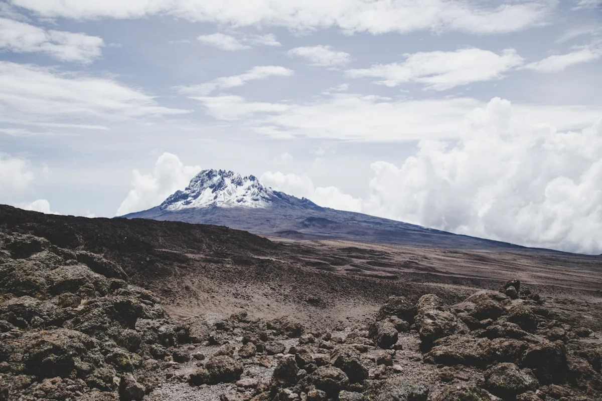
Mount Kilimanjaro is not merely a mountain; it is a towering icon of the African continent and the highest free-standing mountain on Earth. Rising 5,895 metres above the Tanzanian plains, this dormant stratovolcano represents one of the world's most accessible "Seven Summits," offering trekkers the chance to journey from tropical rainforests to arctic glaciers in a matter of days. The Machame Route, often referred to as the "Whiskey Route," is the most popular and scenic path to the summit of Uhuru Peak. Spanning approximately 56 kilometres, this trek is a profound test of physical endurance and mental fortitude, requiring no technical climbing skills but demanding a deep respect for the physiological challenges of extreme altitude. It is a journey through five distinct ecological zones, each with its own unique flora and fauna, culminating in a sunrise over the vast African savannah that remains etched in the memory of every successful climber.
The Kilimanjaro trek is a masterclass in ecological diversity. Unlike many other mountain ranges that belong to a single climatic system, Kilimanjaro is a world unto itself. The journey begins in the Cultivation Zone (800 m to 1,800 m), where the fertile volcanic soil supports lush coffee and banana plantations. As you pass through the park gates, you enter the Montane Rainforest (1,800 m to 2,800 m). This is a realm of ancient trees draped in moss, where the air is thick with humidity and the sounds of Colobus monkeys and exotic birds echo through the canopy. The path is often muddy and slick, winding through a dense green cathedral that feels worlds away from the icy summit.
Emerging from the forest, you enter the Heath and Moorland Zone (2,800 m to 4,000 m). Here, the vegetation thins, replaced by giant heathers and the iconic Dendrosenecio kilimanjari (giant groundsels) and Lobelia deckenii. The views begin to open up, revealing the jagged Shira Plateau and the distant, snow-capped Kibo cone. The air becomes noticeably thinner and crisper. Beyond 4,000 metres lies the Alpine Desert (4,000 m to 5,000 m), a stark, lunar landscape of volcanic rock and sand where only the hardiest lichens survive. Temperatures fluctuate wildly here, from scorching sun during the day to sub-zero chills at night. Finally, the Arctic Zone (above 5,000 m) is a world of ice, scree, and glaciers, where oxygen levels are half of those at sea level and every step requires a monumental effort of will.
The Machame Route is specifically designed to maximise acclimatisation. By following the "walk high, sleep low" principle—climbing to the Lava Tower at 4,630 metres before descending to sleep at Barranco Camp (3,960 m)—trekkers give their bodies the best possible chance to adjust to the thinning air. This strategic pacing is the reason for the route's high success rate compared to shorter paths. However, the physical challenge remains significant. The trek involves long days of walking, steep ascents like the Barranco Wall, and a final summit push that begins in the dead of night, battling extreme cold and exhaustion to reach the crater rim by dawn. It is a journey that rewards the patient and the persistent, offering a perspective on the world that few ever experience.
Mount Kilimanjaro, or "Kilima Njaro" (often translated from Swahili as "Mountain of Greatness" or "Shining Mountain"), has been a focal point of local folklore and international exploration for centuries. For the Chagga people who live on the lower slopes, the mountain is a sacred entity, a source of life-giving water and fertile soil. Their oral traditions speak of the mountain's volcanic past and the spirits that inhabit its peaks. The Chagga have historically been skilled farmers, developing sophisticated irrigation systems that still feed the lush plantations surrounding the mountain today.
The first recorded mention of the mountain by a European was in 1848 by the German missionary Johannes Rebmann, whose reports of a snow-capped peak near the equator were initially met with disbelief by the Royal Geographical Society in London. It wasn't until 1889 that the summit was finally reached. Hans Meyer, a German geographer, and Ludwig Purtscheller, an Austrian mountaineer, achieved the feat on their third attempt, accompanied by a local guide named Yohani Kinyala Lauwo. Lauwo, a member of the Chagga tribe, is a legendary figure in Kilimanjaro history, reportedly living to be over 125 years old and witnessing the transformation of the mountain from an unknown peak to a global trekking destination.
Geologically, Kilimanjaro is a complex volcano composed of three distinct cones: Shira, Mawenzi, and Kibo. Shira is the oldest and has collapsed into a broad plateau. Mawenzi is a jagged, technical peak that is the second highest. Kibo is the youngest and highest, containing the Uhuru Peak summit. While Shira and Mawenzi are extinct, Kibo is classified as dormant; while it hasn't erupted in recorded history, it still emits volcanic gases from its fumaroles. In 1973, Kilimanjaro National Park was established to protect the mountain's unique ecosystems, and in 1987, it was designated a UNESCO World Heritage Site. Today, the mountain stands as a symbol of Tanzanian national pride and a vital part of the country's tourism economy, managed with a focus on conservation and the welfare of the thousands of porters and guides who make every trek possible.
Want more background? Read extended notes on history and cultural context → Learn more
Kilimanjaro's proximity to the equator means it does not experience traditional four-season cycles. Instead, the weather is dictated by wet and dry seasons. Choosing the right window is critical for both safety and the likelihood of reaching the summit.
The Primary Dry Season (June to October): This is widely considered the best time to trek. The weather is generally stable, with clear skies and minimal rainfall. While this is the busiest time on the mountain, the visibility is exceptional, offering stunning views of the surrounding plains and the star-filled African sky. Temperatures are cooler during this period, especially at night, so high-quality insulating gear is essential.
The Secondary Dry Season (January to March): This window offers slightly warmer temperatures than the June–October period. The mornings are typically clear, though clouds may build up in the afternoons. This is an excellent time for those who prefer slightly less crowded trails while still enjoying reliable weather conditions. The dust on the lower trails is more prevalent during these months.
The "Long Rains" (April to May): This is the wettest time of the year. Heavy downpours are frequent, making the forest trails extremely muddy and slippery. Visibility is often poor, and the summit can be shrouded in thick cloud and snow. Trekking during this time is only recommended for very experienced hikers who don't mind getting wet and are prepared for challenging underfoot conditions. Many tour operators do not run treks during these months.
The "Short Rains" (November to December): This period sees intermittent afternoon thunderstorms. While it is possible to trek, you should expect daily rain in the forest and moorland zones. The advantage of this season is the relative solitude on the mountain and the lush, green appearance of the lower slopes. However, the summit push can be significantly more difficult if fresh snow has fallen.
Regardless of the season, weather on Kilimanjaro is notoriously unpredictable. A clear morning can transform into a blizzard within an hour at higher altitudes. Temperatures at the summit regularly drop to -15°C or -20°C, with wind chill making it feel even colder. Proper layering and high-quality waterproofs are non-negotiable requirements for any Kilimanjaro trek.
Day 1: Machame Gate to Machame Camp
Day 2: Machame Camp to Shira 2 Camp
Day 3: Shira 2 Camp to Barranco Camp (via Lava Tower)
Day 4: Barranco Camp to Karanga Camp
Day 5: Karanga Camp to Barafu Camp
Day 6: Barafu Camp to Uhuru Peak to Mweka Camp
Day 7: Mweka Camp to Mweka Gate
Important Notes:
Planning a Kilimanjaro trek requires significant lead time, typically 4 to 9 months. Unlike many other major treks, you cannot hike Kilimanjaro independently; Tanzanian law requires all trekkers to be accompanied by a licensed guide and a registered tour operator. Choosing a reputable operator is the most important decision you will make. Look for companies that are members of the Kilimanjaro Porters Assistance Project (KPAP), which ensures fair wages, proper clothing, and ethical treatment of the mountain crew.
Physical preparation should focus on cardiovascular endurance and leg strength. While you don't need to be an elite athlete, you should be comfortable walking for 6–8 hours a day with a light daypack. Training should include hiking on uneven terrain with elevation gain, ideally wearing the boots you intend to use on the mountain. Mental preparation is equally important; the summit night is a test of grit, and being mentally prepared for discomfort, cold, and fatigue will significantly increase your chances of success.
Moshi is the traditional base for Kilimanjaro treks. It is a vibrant town with a range of accommodation from budget hostels to comfortable hotels. Most operators include airport transfers from Kilimanjaro International Airport (JRO) and pre/post-trek accommodation in their packages. Ensure you have at least one full day in Moshi before starting the trek to check gear, meet your guides, and recover from international travel.
On the Machame Route, accommodation is exclusively in high-quality mountain tents. There are no permanent huts or lodges on this route (unlike the Marangu Route). Your tour operator provides the tents, which are set up and taken down daily by the porter crew.
Campsite Facilities:
What is NOT Provided:
Booking Requirements:
Access to Kilimanjaro National Park is strictly controlled by the Kilimanjaro National Park Authority (KINAPA). You cannot simply turn up and hike; every trekker must be part of an organised group with a licensed guide. The "permit" is essentially the payment of various park fees, which your tour operator handles on your behalf.
Breakdown of Park Fees (subject to change):
Booking Strategy:
Tipping Culture: While not a "permit" in the legal sense, tipping is a mandatory social contract on Kilimanjaro. The crew (guides, assistant guides, cooks, and porters) rely on tips for a significant portion of their income. Budget approximately US$250–$350 per trekker for the total tip pool, which is distributed at the "tipping ceremony" on the final day.

Detailed route notes, maps, logistics & tips for the Kilimanjaro Trek (PDF).

Precisely traced GPX for the Kilimanjaro Trek, ready for your GPS or favourite mapping app.
Tanzania offers some of the world's most spectacular natural and cultural experiences. Many trekkers choose to add an extension to their Kilimanjaro journey:
Altitude Sickness (AMS): The primary safety concern on Kilimanjaro is Acute Mountain Sickness. Because the mountain rises so steeply from the plains, the risk of AMS is high. Symptoms include headache, nausea, dizziness, and loss of appetite. Most trekkers will experience mild AMS. However, it can progress to High Altitude Pulmonary Edema (HAPE) or High Altitude Cerebral Edema (HACE), both of which are life-threatening. The only cure for severe altitude sickness is immediate descent.
Safety Protocols:
Weather Hazards: Hypothermia is a genuine risk, particularly on summit night. Temperatures can drop well below -15°C, and high winds are common. Proper layering—merino wool base layers, insulating mid-layers, and a windproof outer shell—is vital. Frostbite is rare but possible if extremities (fingers, toes, nose) are not properly protected.
Travel Insurance: It is mandatory to have travel insurance that specifically covers high-altitude trekking up to 6,000 metres. Many standard policies only cover up to 3,000 m or 4,500 m. Ensure your policy includes emergency helicopter evacuation.
The Barranco Wall: Often the most talked-about section of the Machame Route. This 257-metre rock face looks intimidating from the camp, but it is a non-technical scramble that most trekkers find to be the most fun part of the journey. There is one specific spot known as the "Kissing Rock," where the trail narrows and you must hug the rock face to pass. The views from the top of the wall are some of the best on the mountain.
Lava Tower: A 90-metre tall volcanic plug that stands at 4,630 metres. It is a stark reminder of the mountain's volcanic origins. While most trekkers simply have lunch at its base for acclimatisation, it is a significant landmark that marks the transition into the high alpine desert.
The Ash Pit: For those with extra energy and time at the summit, a detour into the Reusch Crater to see the Ash Pit is possible. This is the most recent volcanic vent on Kibo and still emits a faint smell of sulphur. It is a surreal, desolate place that feels like the very centre of the earth.
Shira Plateau: One of the highest plateaus on earth, the Shira Plateau is the remains of Kilimanjaro's first volcanic cone. Walking across this vast, open expanse provides a sense of the mountain's immense scale and offers incredible views of the sunset above the clouds.
Kilimanjaro is a fragile ecosystem under significant pressure from the thousands of people who visit each year. As a trekker, you have a responsibility to minimise your impact on this UNESCO World Heritage site.
Leave No Trace Principles for Kilimanjaro: