Mount Kilimanjaro - Machame Route
Mount Kilimanjaro, a dormant volcano in Tanzania, is Africa's highest peak and the world's tallest free-standing mountain. Standing at an impressive 5,895 metres (5,895 m) above sea level, it offers a challenging yet achievable ascent for trekkers of varying experience levels. The Machame Route, often referred to as the "Whiskey Route," is one of the most popular and scenic paths to the summit, known for its high success rate and stunning vistas. This route traverses diverse ecological zones, from lush rainforests to alpine deserts and finally to the arctic summit zone, providing a comprehensive Kilimanjaro experience.
- Distance: 62.0 km (one-way)
- Duration: 6-7 days
- Elevation Gain: 4,000 m
- Difficulty: Challenging
- Best Time: June to October (dry season) and December to February (short rains)
- Closest City: Moshi
- Trailhead Access: Nearest airport: Kilimanjaro International Airport (JRO). Take a taxi or pre-booked shuttle to Moshi, then another taxi to Machame Gate. Road is paved to Moshi, then rougher to the gate. Driving time from Moshi: 1 hour. Parking available. Park fees and registration required at the gate.
- Coordinates: -3.0674, 37.3546
Overview
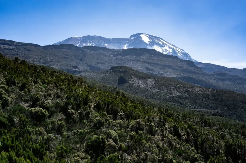
The Machame Route is celebrated for its beauty and its gradual acclimatisation profile, which significantly increases the chances of reaching Uhuru Peak, Kilimanjaro's summit. Unlike some other routes, Machame offers a "climb high, sleep low" strategy, allowing your body to adapt better to the increasing altitude. The trek begins in the verdant rainforest, where you might spot colobus monkeys and diverse birdlife. As you ascend, the landscape transforms dramatically through the heather and moorland zones, characterized by giant heathers, senecios, and lobelias. Higher still, you enter the alpine desert, a stark and rocky environment, before finally reaching the arctic summit zone, a world of ice and snow.
The route's popularity stems from its scenic diversity and the fact that it is not overly crowded, especially compared to the Marangu Route. The trek typically takes six or seven days, with the extra day on a seven-day itinerary dedicated to further acclimatisation, which is highly recommended for a more comfortable and successful summit attempt. The Machame Route approaches the summit from the south and descends via the Mweka Route, offering different perspectives of the mountain and its surroundings.
The journey is more than just a physical challenge; it's an immersion into a unique ecosystem and a test of mental fortitude. The camaraderie built with fellow trekkers and guides, the breathtaking sunrises over the clouds, and the sheer accomplishment of standing on the Roof of Africa make the Machame Route an unforgettable adventure.
History and Cultural Context
Mount Kilimanjaro has held cultural and spiritual significance for the local Chagga people for centuries. They consider the mountain a sacred deity, Kibo, and have long revered its snow-capped peaks. The mountain's name itself is believed to be derived from a Swahili phrase, "Kilima-Njaro," meaning "Mountain of Caravans" or "Mountain of Greatness."
The first recorded European ascent of Kilimanjaro was in 1889 by German geographer Hans Meyer and Austrian mountaineer Ludwig Purtscheller. They reached the summit of Kibo, the highest peak, via the southern ice fields. Prior to this, various expeditions had attempted to scale the mountain, but none had succeeded in reaching the true summit. Meyer's expedition was meticulously planned, and they were guided by local Chagga guides who possessed invaluable knowledge of the mountain's lower slopes.
The Machame Route, while not historically significant in the same way as the first ascents, has become a modern classic. Its development as a trekking route reflects the growing interest in adventure tourism in Tanzania and the desire to offer trekkers a more scenic and acclimatisation-friendly path to the summit. The route's name, "Machame," refers to the village near the mountain's base where the trek typically begins. The local communities surrounding Kilimanjaro, primarily the Chagga people, have a rich agricultural heritage, with coffee and banana plantations thriving on the fertile volcanic soil of the mountain's lower slopes. Their culture is deeply intertwined with the mountain, viewing it as a source of life and spiritual power.
Seasonal Highlights and Weather Reality
Mount Kilimanjaro experiences distinct seasons, each offering a different trekking experience. Understanding these seasons is crucial for planning your climb.
Dry Seasons (June to October and December to February): These are the most popular times to climb Kilimanjaro. The skies are generally clear, offering excellent visibility and stable weather conditions. Temperatures are cooler, especially at higher altitudes, but the lack of rain makes for more comfortable trekking. June to October is the longest dry season, with cooler temperatures. December to February is warmer but still dry, with occasional short showers.
Rainy Seasons (March to May and November): These periods are characterized by heavy rainfall, particularly the long rains from March to May. Trails can become muddy and slippery, and visibility is often poor due to cloud cover. While it's possible to climb during these times, it is generally less advisable due to the challenging conditions and lower success rates. November is a shorter, less intense rainy period.
Summit Conditions: Regardless of the season, the summit of Kilimanjaro, Uhuru Peak, is always cold. Temperatures can drop to -10°C (-10°C) or even -20°C (--15°C) with wind chill, especially at night during the summit push. Snow and ice are present year-round on the upper slopes and crater rim. The weather on Kilimanjaro is notoriously unpredictable, and it's not uncommon to experience all four seasons in a single day, even during the dry seasons.
Ecological Zones: The Machame Route passes through five distinct ecological zones:
- Rainforest (1,800–2,800 m): Lush and humid, with abundant flora and fauna.
- Heath and Moorland (2,800–4,000 m): Characterized by giant heathers, senecios, and lobelias.
- Alpine Desert (4,000–5,000 m): Sparse vegetation, rocky terrain, and a stark, moon-like landscape.
- Arctic Zone (above 5,000 m): Bare rock, ice, and snow.
Recommended Itinerary
6-Day Machame Route Itinerary
Day 1: Machame Gate (1,800 m) to Machame Camp (3,000 m)
- Distance: 11 km
- Time: 5–6 hours
- Elevation Gain: 1,200 m
- Start at Machame Gate, register, and begin trekking through the dense rainforest.
- The path is well-maintained but can be muddy.
- Observe diverse plant life and listen for the calls of monkeys.
- Arrive at Machame Camp, situated in a forest clearing.
- Enjoy dinner and an overnight stay in tents.
Day 2: Machame Camp (3,000 m) to Shira Camp (3,850 m)
- Distance: 5 km
- Time: 4–5 hours
- Elevation Gain: 850 m
- Ascend out of the rainforest into the heath and moorland zone.
- The terrain becomes rockier, with fewer trees and more giant heathers and senecios.
- Enjoy panoramic views of Mount Kilimanjaro and the surrounding plains.
- Arrive at Shira Camp, located on a high-altitude plateau with stunning vistas.
- Acclimatise and enjoy the sunset over the Shira Ridge.
Day 3: Shira Camp (3,850 m) to Barranco Camp (3,950 m)
- Distance: 10 km
- Time: 6–7 hours
- Elevation Gain: 100 m (net), but involves significant ups and downs.
- Trek across the Shira Plateau, passing Lava Tower (4,600 m) for acclimatisation.
- Descend into the Barranco Valley, a dramatic gorge.
- Arrive at Barranco Camp, nestled beneath the imposing Barranco Wall.
- This day is crucial for acclimatisation, with a net gain of only 100 metres but significant altitude exposure.
Day 4: Barranco Camp (3,950 m) to Karanga Camp (4,000 m)
- Distance: 5 km
- Time: 3–4 hours
- Elevation Gain: 50 m
- The highlight of the day is the ascent of the Barranco Wall, a challenging but rewarding scramble.
- After the wall, the terrain is less steep, leading to Karanga Camp.
- Karanga Camp is situated in a valley with excellent views of the southern ice fields.
- This is a shorter day, allowing for rest and further acclimatisation.
Day 5: Karanga Camp (4,000 m) to Barafu Camp (4,650 m)
- Distance: 4 km
- Time: 3–4 hours
- Elevation Gain: 650 m
- Trek through an alpine desert landscape with sparse vegetation.
- The path becomes steeper as you approach Barafu Camp, the base camp for the summit push.
- Rest and prepare for the summit attempt, which begins late in the evening.
- Early dinner and an early bedtime are essential.
Day 6: Barafu Camp (4,650 m) to Uhuru Peak (5,895 m) and descend to Mweka Camp (3,100 m)
- Distance: 15 km (summit push and descent)
- Time: 7–8 hours to summit, 4–5 hours descent to Barafu, 3–4 hours descent to Mweka
- Elevation Gain: 1,245 m to summit, 2,795 m descent to Mweka Camp
- Begin the summit attempt around midnight.
- Trek through the night, navigating scree slopes and rocky terrain.
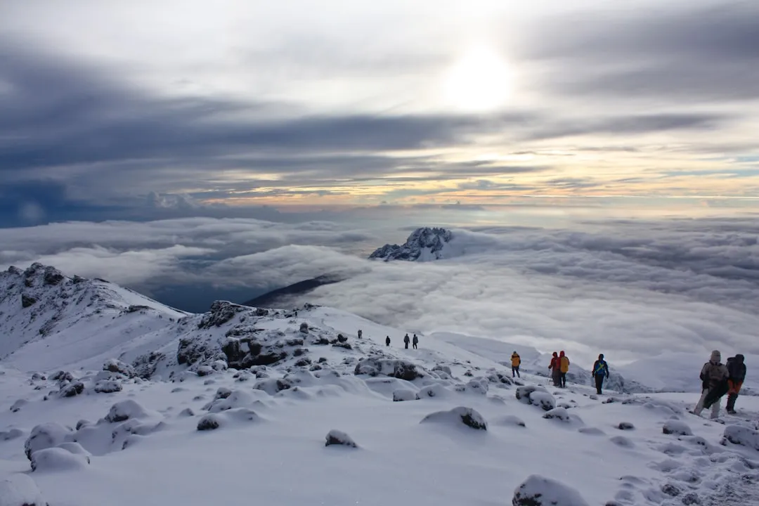
- Reach Stella Point (5,756 m) at sunrise, then continue to Uhuru Peak, the highest point in Africa.
- Celebrate your achievement and take in the breathtaking views.
- Begin the long descent back to Barafu Camp for a short rest, then continue down to Mweka Camp.
- This is the most demanding day of the trek.
Optional 7-Day Itinerary: Adds an extra day at Karanga Camp or Barafu Camp for enhanced acclimatisation, significantly improving summit success rates and comfort.
Planning and Bookings
Book Your Trip
Everything you need to plan your journey
Accommodation
Find places to stay near Moshi
Flights
Search flights to Moshi
Essential Preparation
Climbing Mount Kilimanjaro requires careful planning and preparation. The first step is to choose a reputable tour operator. These operators handle park fees, guide and porter salaries, food, camping equipment, and often arrange airport transfers and pre-trek accommodation in Moshi. It is highly recommended to book your trek at least 3-6 months in advance, especially if you plan to climb during the peak dry seasons.
Fitness: While Kilimanjaro is not technically difficult, it is a strenuous high-altitude trek. A good level of cardiovascular fitness is essential. Begin a training program at least 2-3 months before your climb, focusing on hiking with a weighted backpack, cardiovascular exercises (running, cycling, swimming), and strength training for your legs and core. Practice hiking on varied terrain and include some steep ascents and descents.
Moshi: Moshi is the primary gateway town for Kilimanjaro climbs. It offers a range of accommodation options, from budget guesthouses to comfortable hotels. It's also where you'll meet your guides, undergo a briefing, and potentially rent any last-minute gear. Moshi has banks, ATMs, supermarkets, and outdoor gear shops.
Logistics: Your tour operator will typically arrange transport from Kilimanjaro International Airport (JRO) to your hotel in Moshi. They will also arrange transport from Moshi to Machame Gate on the morning of your trek and from Mweka Gate back to Moshi upon completion.
Trail Accommodation
Accommodation on the Machame Route consists of camping. You will sleep in sturdy, waterproof tents provided by your tour operator. Each camp is set up in designated areas within the national park.
Camp Facilities:
- Tents: High-quality, four-season tents are provided for sleeping, dining, and toilet facilities.
- Sleeping Mats: Comfortable sleeping mats are usually included.
- Dining Tent: A separate tent is set up for meals, providing shelter from the elements.
- Toilet Tent: A portable toilet tent is set up at each camp for privacy.
- Porters: Porters will carry all your camping equipment, food, and personal luggage (within specified weight limits).
What's NOT Provided:
- Sleeping bags (you must bring your own, rated for cold temperatures)
- Pillows (though some operators provide them)
- Personal items
- Food (your operator provides all meals)
Seasonal Availability: Camps are available year-round, but the dry seasons (June-October and December-February) offer the most pleasant camping conditions.
Costs: The cost of camping is included in your overall tour package. Park fees, which cover the use of campsites, are substantial and are typically factored into the tour price.
Required Gear
- Hiking Boots: Sturdy, waterproof, broken-in hiking boots with good ankle support are essential.
- Trekking Poles: Highly recommended for stability and reducing strain on your knees, especially during descents.
- Waterproof Jacket: A high-quality, breathable waterproof and windproof jacket (e.g., Gore-Tex).
- Waterproof Overtrousers: Essential for protection against rain and wind.
- Warm Layers: Multiple layers are key. Include thermal base layers (merino wool or synthetic), fleece mid-layers, and an insulated down or synthetic jacket for summit night.
- Headlamp: With extra batteries. Crucial for summit night and navigating around camp in the dark.
- Sunglasses: High UV protection, essential for glare from snow and ice.
- Sun Hat: Wide-brimmed for sun protection during the day.
- Warm Hat (Beanie): To retain heat, especially at altitude and during summit night.
- Gloves: Warm, waterproof gloves or mittens for summit night, and liner gloves for cooler days.
- Backpack: A comfortable daypack (25-35 litres) for carrying essentials during the day's trek. Porters will carry your main duffel bag (usually up to 15 kg).
- Sleeping Bag: A 4-season sleeping bag rated to at least -15°C (-17°C) is recommended.
- First-Aid Kit: Personal kit including blister treatment, pain relievers, antiseptic wipes, and any personal medications. Your guides will also carry a comprehensive medical kit.
What to Bring
- Food and Snacks: While your operator provides meals, bring high-energy snacks like energy bars, nuts, dried fruit, and chocolate for extra fuel during the trek and summit push.
- Water Bottles/Hydration Reservoir: Carry at least 3 litres of water capacity. Hydration is critical at altitude.
- Water Purification: While guides will boil water, it's wise to carry purification tablets or a filter as a backup.
- Sunscreen: High SPF (50+) sunscreen, as the sun is intense at altitude.
- Lip Balm: With SPF protection.
- Toiletries: Biodegradable soap, toothbrush, toothpaste, wet wipes, hand sanitiser.
- Personal Medications: Any prescription or over-the-counter medications you regularly use.
- Camera and Extra Batteries/Power Bank: To capture the stunning scenery.
- Insect Repellent: Although less of an issue at higher altitudes, it can be useful in the rainforest.
- Small Towel: Quick-drying.
- Duffel Bag: A large, durable duffel bag (usually 80-100 litres) for porters to carry your main gear.
- Passport and Visa: Ensure they are valid.
- Cash: For tips for guides and porters, and for any personal purchases in Moshi.
Permits
To climb Mount Kilimanjaro, you will need to obtain several permits and pay associated fees. These are typically handled by your chosen tour operator as part of your package, but it's important to understand what they cover.
National Park Entry Fees: These are daily fees charged for each day you spend within Kilimanjaro National Park. The rates can vary but are generally around US$70-80 per person per day.
Camping Fees: For routes like Machame that involve camping, there are additional daily fees for using the designated campsites. These fees are also substantial, often in the range of US$50-60 per person per night.
Rescue Fees: A mandatory rescue fee is charged to cover potential emergency evacuations. This fee is typically around US$10-20 per person.
Guide and Porter Fees: While not strictly permits, the wages for your guides, cooks, and porters are a significant part of the cost and are regulated by park authorities to ensure fair treatment of the mountain crew.
Booking Process: Your tour operator will manage the acquisition of all necessary permits and fees. They will require your passport details and the exact dates of your trek. It is crucial to book well in advance, as permits can be limited, especially during peak seasons.
Cost Breakdown: While exact figures fluctuate, expect park and camping fees to constitute a significant portion of your overall trek cost, often amounting to several hundred US dollars per person for a 6-7 day climb.
Other Activities in the Area
Before or after your Kilimanjaro climb, the region around Moshi and Arusha offers a wealth of activities:
- Safari in Tarangire National Park: Known for its large elephant herds and baobab trees, Tarangire is a fantastic destination for a day trip or a short safari.
- Ngorongoro Crater Tour: A UNESCO World Heritage Site, the Ngorongoro Crater is a collapsed volcano caldera teeming with wildlife, offering incredible game viewing opportunities.
- Lake Manyara National Park: Famous for its tree-climbing lions and large flamingo populations, this park offers diverse landscapes and excellent birdwatching.
- Chagga Cultural Tours: Learn about the local Chagga culture, visit coffee plantations, explore traditional homes, and understand their relationship with Kilimanjaro.
- Hot Springs Visit: Relax and rejuvenate at the Kikuletwa Hot Springs (also known as Chemka Oasis), a beautiful natural pool surrounded by lush vegetation.
- Moshi Town Exploration: Wander through the local markets, visit the clock tower, and enjoy the vibrant atmosphere of this bustling town.
- Waterfalls: Explore nearby waterfalls such as Materuni Waterfalls, which also offers a coffee tour experience.
Safety and Conditions
Altitude Sickness (Acute Mountain Sickness - AMS): This is the most significant risk when climbing Kilimanjaro. Symptoms include headache, nausea, dizziness, fatigue, and loss of appetite. The Machame Route's gradual ascent profile is designed to minimise AMS risk. Your guides are trained to recognise AMS symptoms and will monitor you closely. The best prevention is slow ascent, adequate hydration, and avoiding alcohol and strenuous activity on arrival.
Hypothermia: Temperatures at higher altitudes can drop significantly, especially on summit night. Layering clothing, staying dry, and consuming warm fluids are crucial. Ensure you have adequate warm gear.
Physical Exertion: The climb is physically demanding. Pushing yourself too hard can lead to exhaustion and increase the risk of AMS. Listen to your body and your guides.
Weather: Kilimanjaro's weather is unpredictable. Be prepared for sun, rain, wind, and cold, sometimes all in the same day. Summit night can be particularly harsh with strong winds and freezing temperatures.
Guides and Porters: Your trekking team is experienced and trained in safety protocols. They carry comprehensive first-aid kits, including oxygen, and know how to manage emergencies. Trust their judgment.
Communication: Mobile phone signal is generally non-existent on the mountain. Guides carry satellite phones for emergencies.
Pre-Climb Medical Check: It is advisable to consult your doctor before your climb, especially if you have any pre-existing medical conditions. Discuss altitude sickness medication (e.g., Diamox) with your doctor.
Emergency Evacuation: Most reputable operators include emergency evacuation services in their packages. Ensure you understand the procedures.
Side Trips and Points of Interest
Lava Tower (4,600 m): Located on Day 3 of the Machame Route, Lava Tower is a prominent volcanic plug. It's a popular acclimatisation stop, offering a chance to stretch your legs and enjoy expansive views. The surrounding area is starkly beautiful, showcasing the alpine desert environment.
Barranco Wall: This is a major highlight of the Machame Route, encountered on Day 4. It's a challenging scramble, not a technical climb, but requires using your hands for balance and support. The ascent offers thrilling moments and rewards with spectacular views from the top.
Shira Plateau: On Day 2, you traverse the Shira Plateau, a vast, high-altitude expanse offering breathtaking panoramas of Kilimanjaro's western side and the surrounding landscape. The plateau is dotted with unique flora like giant senecios and lobelias.
Crater Rim Views: As you approach Stella Point and Uhuru Peak on summit night, you'll witness incredible views of the crater rim and the vast glacial formations. The sunrise from this vantage point is an unforgettable experience.
Glacial Fields: While receding rapidly due to climate change, the remaining glaciers and ice fields near the summit are a stark reminder of Kilimanjaro's icy crown. They offer a dramatic contrast to the volcanic rock and scree.
Leave No Trace
Practising Leave No Trace principles is paramount on Mount Kilimanjaro to preserve its fragile ecosystem and ensure a positive experience for all visitors. Your trekking team will adhere to these principles, and your cooperation is essential.
- Pack It In, Pack It Out: All litter, including food scraps, wrappers, and any other waste, must be carried back down the mountain. Do not bury or burn trash.
- Stay on the Trail: Stick to the designated paths to prevent erosion and protect delicate vegetation. Venturing off-trail can damage the environment and increase the risk of getting lost.
- Respect Wildlife: Do not feed any animals you encounter. This can disrupt their natural behaviours and diets, and some animals can become aggressive.
- Dispose of Waste Properly: Use designated toilets at campsites. If no toilet is available, dig a cathole at least 60 metres away from water sources, trails, and campsites. Pack out all toilet paper.
- Leave What You Find: Do not take rocks, plants, or any natural or cultural artifacts from the mountain.
- Minimise Campfire Impacts: Campfires are generally not permitted on Kilimanjaro. Use the stoves provided by your operator for cooking.
- Be Considerate of Other Visitors: Keep noise levels down, especially at campsites, and respect the privacy of other trekkers.
- Travel and Camp on Durable Surfaces: Use established campsites and trails.
By following these guidelines, you contribute to the conservation of Mount Kilimanjaro for future generations and demonstrate respect for the natural environment and the local culture.