Khar Nuur to Uvs Nuur Trek - The Great Basin Traverse
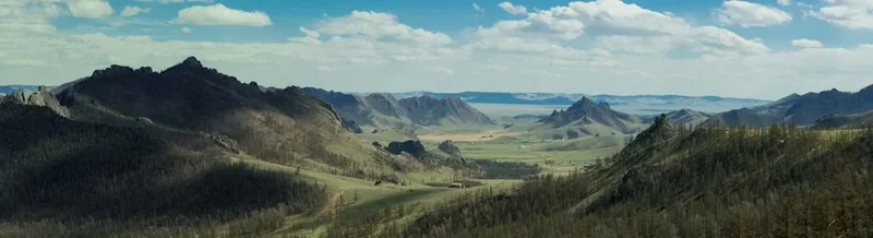
The Khar Nuur to Uvs Nuur Trek is one of Mongolia’s most visually arresting and physically demanding wilderness expeditions. Spanning approximately 120 kilometres across the remote Zavkhan and Uvs provinces, this journey connects two of Central Asia’s most distinct hydrological wonders. Starting at the sapphire-blue waters of Khar Nuur (Black Lake), which is uniquely hemmed in by the towering golden sands of the Bor Khyariin Els dunes, the route traverses a vast, prehistoric landscape of high-altitude steppe, semi-arid desert, and seasonal river systems before culminating at the shores of Uvs Nuur. Uvs Nuur is Mongolia’s largest lake by surface area and a UNESCO World Heritage site, serving as a vital sanctuary for migratory birds and a remnant of a massive inland sea that once covered the region. This is not a marked trail in the traditional sense; it is a navigational challenge through a land without fences, where the silence is absolute and the scale of the horizon is humbling. For the experienced trekker, it offers a rare opportunity to witness the raw intersection of shifting desert sands and alpine waters in a region rarely visited by international travellers.
- Distance: 120.0 km point-to-point
- Duration: 6–8 days
- Season: June to September (optimal window for stable weather and river crossings)
- Accommodation: Strictly wild camping (no formal huts or campsites)
- Highest point: Approximately 2,100 m (unnamed passes in the transition zones)
- Difficulty: Challenging (requires advanced navigation, self-sufficiency, and high fitness)
- Direction: Generally South to North (Khar Nuur to Uvs Nuur)
Overview
The Khar Nuur to Uvs Nuur Trek is a masterclass in ecological contrast. The journey begins in the Zavkhan province at Khar Nuur, a freshwater lake situated at an elevation of 1,980 metres. What makes this starting point world-class is the immediate proximity of the Bor Khyariin Els sand dunes. These massive dunes, some rising over 200 metres from the lake’s edge, create a surreal landscape where deep blue water meets scorched orange sand. The first two days of the trek involve navigating the periphery of these dunes, a task that tests the endurance of the calves and the resolve of the spirit. The sand is fine and relentless, but the reward is a series of vistas that feel more like a mirage than a reality.
As the trek progresses northward, the desert gives way to the classic Mongolian steppe—a rolling sea of grass punctuated by the occasional "ger" (yurt) of nomadic families. This middle section of the trek is defined by the vastness of the Great Lakes Basin. The air is thin and dry, and the weather can shift from blistering sun to sudden, violent thunderstorms within an hour. Trekkers must cross several seasonal watercourses and the Tes River, the primary feeder for Uvs Nuur. These crossings require careful timing and an understanding of local rainfall patterns, as the rivers can swell rapidly after mountain storms.
The final approach to Uvs Nuur brings a change in both terrain and atmosphere. The ground becomes increasingly saline, reflecting the lake’s status as a terminal salt lake. Uvs Nuur itself is a massive, shallow basin, five times saltier than the ocean in certain sections, and surrounded by wetlands that host over 300 species of birds. Reaching its shores provides a profound sense of completion; you have walked from a hidden mountain gem to the lowest point of the Great Lakes Basin. This trek is not merely a physical journey but a deep immersion into the "Great Empty" of Western Mongolia, where the lack of infrastructure is compensated for by an overwhelming sense of freedom and a connection to a nomadic way of life that has remained largely unchanged for centuries.
History and Cultural Context
The landscape between Khar Nuur and Uvs Nuur is a living museum of Central Asian history. The Uvs Nuur Basin has been inhabited for millennia, serving as a crossroads for various nomadic empires, including the Xiongnu, the Turks, and the Mongols. The region is dotted with "khereksur" (bronze-age burial mounds) and "balbal" (stone man-statues), silent sentinels that mark the graves of ancient warriors and leaders. These archaeological sites are not cordoned off or signposted; they are part of the natural landscape, often used by modern herders as landmarks or shelters for livestock.
Culturally, this region is the heartland of the Bayad and Khoton ethnic groups, known for their distinct dialects and deep-rooted nomadic traditions. The herders you may encounter along the route are practitioners of a seasonal migration system that is perfectly tuned to the harsh environment. In the summer, they move their livestock—sheep, goats, horses, and camels—to the cooler, high-altitude pastures near the lakes. Hospitality is a cornerstone of Mongolian culture; it is not uncommon for a lone trekker to be invited into a ger for "suutei tsai" (salty milk tea) and "aaruul" (dried curd). These encounters provide a vital human dimension to the trek, offering insights into a lifestyle defined by resilience and a profound respect for the "Khökh Tenger" (Eternal Blue Sky).
The Uvs Nuur Basin was designated a UNESCO World Heritage site in 2003, recognised as one of the best-preserved examples of the Eurasian steppe ecosystem. It represents a "natural laboratory" where the transition from high-mountain tundra to desert occurs over a relatively short distance. Historically, the lake was part of a much larger prehistoric sea, and the salt flats surrounding it today are the evaporated remains of that ancient world. Walking this route is, in many ways, a journey through geological time, following the same paths used by Silk Road traders and nomadic tribes for over two thousand years.
Want more background? Read extended notes on history and cultural context → Learn more
Seasonal Highlights and Weather Reality
The window for trekking in Western Mongolia is narrow due to the extreme continental climate. Temperatures can fluctuate by as much as 30 degrees Celsius within a single 24-hour period, and the region is prone to high winds that can make navigation and tent-pitching difficult.
Summer (June to August): This is the primary trekking season. Days are long, with daylight lasting until 10:00 PM, providing ample time for distance coverage. Daytime temperatures typically range from 20°C to 30°C, though it can feel much hotter in the sand dunes. Nights are cool, often dropping to 5°C or 10°C. July is the wettest month; while rain is generally infrequent, when it does fall, it often comes in the form of intense, short-lived thunderstorms that can turn dry gullies into raging torrents.
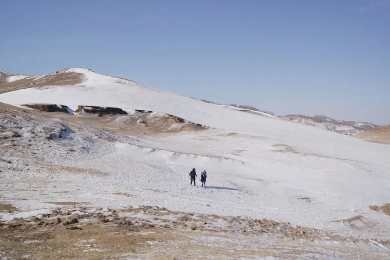
Autumn (September): Many experienced trekkers prefer September. The air is exceptionally clear, the biting insects of the mid-summer have vanished, and the heat of the dunes is more manageable. However, the risk of night-time frosts increases significantly, and snow can fall on the higher passes as early as the second week of September. The landscape turns a brilliant gold, making for spectacular photography.
Winter and Spring (October to May): Trekking during this period is strictly for professional expeditions. Temperatures in the Uvs Nuur Basin can drop to -40°C or lower, and the region is buried under snow and ice. Spring (April and May) is notoriously windy, with dust storms that can reduce visibility to near zero. Most nomadic families are in their winter camps during this time, and the lack of water sources (as everything is frozen) makes self-supported trekking nearly impossible.
Recommended Itinerary
8-Day Khar Nuur to Uvs Nuur Expedition
Day 1: Khar Nuur Trailhead to East Dune Camp
- Distance: 12 km
- Elevation gain: 150 m
- Time: 5–6 hours
- Arrival at Khar Nuur via 4x4 from Ulaangom
- Initial trek along the eastern shore where the Bor Khyariin Els dunes meet the water
- Challenging walking on soft sand; gaiters are essential
- Camp on a high ridge overlooking the lake for sunset
- The contrast between the deep blue water and the orange dunes is most dramatic in the late afternoon light
Day 2: Traversing the Bor Khyariin Els
- Distance: 15 km
- Elevation gain: 300 m
- Time: 7–8 hours
- Deep immersion into the dune system, navigating between high peaks
- Requires careful GPS work as landmarks shift with the wind
- Find a sheltered "bowl" between dunes for camping to avoid night winds
- Water must be carried from the lake; no sources exist within the dunes
- This is the most physically taxing day due to the terrain
Day 3: Dunes to the Northern Steppe
- Distance: 18 km
- Elevation loss: 200 m
- Time: 6–7 hours
- Transition from sand to hard-packed gravel and short-grass steppe
- First sightings of nomadic gers and large herds of horses
- Cross the first of several small seasonal streams
- Camp near a nomadic settlement (with permission) or by a stream
- The walking becomes faster and easier as the ground firms up
Day 4: The Tes River Approach
- Distance: 20 km
- Elevation gain: 50 m
- Time: 7–8 hours
- Long traverse of the open steppe with wide-angle horizons
- Navigate toward the green ribbon of vegetation marking the Tes River valley
- Identify a safe crossing point (may require scouting several kilometres upstream)
- Camp on the southern bank of the Tes River
- Abundant birdlife and the sound of running water provide a change in atmosphere
Day 5: Crossing the Tes and the Middle Basin
- Distance: 16 km
- Elevation gain: 100 m
- Time: 6–7 hours
- Morning river crossing (best done when water levels are lowest)
- Enter the middle section of the Great Lakes Basin
- Terrain becomes more arid with sagebrush and low shrubs
- Camp in a dry wash or behind a rocky outcrop for wind protection
- Total isolation; unlikely to see other people in this section
Day 6: The Saline Flats
- Distance: 18 km
- Elevation loss: 150 m
- Time: 6–7 hours
- The ground begins to show white salt crusts (solonchak)
- Mirages are common on the flat, shimmering horizon
- Distant views of the Kharkhiraa and Turgen mountains to the west
- Camp near the edge of the Uvs Nuur wetlands
- Be cautious of boggy ground near the lake margins
Day 7: Uvs Nuur Shoreline
- Distance: 14 km
- Elevation gain: 0 m
- Time: 5–6 hours
- Final push to the actual shoreline of Mongolia’s largest lake
- Explore the reed beds and observe migratory waterfowl (pelicans, cranes, geese)
- The water is brackish and not suitable for drinking without heavy filtration/distillation
- Celebratory final camp on the shores of the "Inland Sea"
- Reflect on the 120 km journey across the basin
Day 8: Extraction to Ulaangom
- Distance: 7 km
- Elevation gain: 20 m
- Time: 2–3 hours
- Short walk to a pre-arranged pickup point on the main dirt track
- 4x4 transfer back to Ulaangom (approx. 2–3 hours)
- Hot shower and celebratory meal in Ulaangom
- Evening flight or bus departure
Important Notes:
- There are no marked trails; a GPS with topographic maps is mandatory
- Water management is the single biggest challenge; plan for 2-day stretches without reliable sources
- The route is flexible; herder tracks often provide the easiest walking
- Always ask permission before camping near a nomadic family's ger
- Pack out all waste; the desert and steppe ecosystems are extremely slow to recover
Planning and Bookings
Book Your Trip
Everything you need to plan your journey
Accommodation
Find places to stay near Ulaangom
Flights
Search flights to Ulaangom
Essential Preparation
Trekking in Western Mongolia requires a level of logistical planning far beyond a standard mountain hike. There are no trailheads, no signage, and no rescue services. Your primary base will be Ulaangom, the capital of Uvs Province. You must coordinate your 4x4 transport to Khar Nuur and your pickup from Uvs Nuur well in advance. Most trekkers hire a local driver and a Russian UAZ van or a modern Land Cruiser. These drivers are experts at navigating the trackless steppe and can often act as informal translators if you encounter herders.
Fitness is paramount. While the elevation gain is not extreme (1,500 m over 120 km), the terrain is punishing. Walking on soft sand for two days followed by uneven, tufted grass (tussock) requires strong ankles and high cardiovascular endurance. You should be comfortable carrying a 20–25 kg pack, as you will need to carry several days' worth of water and all your food.
Trail Accommodation
This is a pure wilderness trek. There are no huts, lodges, or established campsites along the route. You will be wild camping every night.
Camping Considerations:
- Site Selection: Look for natural windbreaks. The Mongolian steppe is notoriously windy, and a tent pitched in an exposed area can easily be damaged.
- Water Access: Plan your camps around the few reliable water sources (Khar Nuur, Tes River, and occasional wells). In the dunes, you must carry all water.
- Nomadic Etiquette: If you camp near a ger, it is polite to approach the family first. They may offer you a spot near their animals for protection against wolves, or simply point you toward the best grass.
- Facilities: None. You must follow strict Leave No Trace principles for waste disposal.
- Costs: There are no camping fees, but you should budget for small gifts (tobacco, sweets, or useful tools) for nomadic families who assist you.
Required Gear
- Tent: A high-quality, 4-season tent with a strong pole structure to withstand high winds.
- Backpack: 65–75L capacity with a robust suspension system.
- Footwear: Sturdy, waterproof hiking boots with good ankle support. Sand gaiters are highly recommended for the Bor Khyariin Els section.
- Navigation: Handheld GPS (Garmin or similar) with spare batteries, plus paper maps and a compass as backup.
- Satellite Communicator: A Garmin inReach or Zoleo is essential. There is zero mobile coverage for 95% of the route.
- Sleeping System: A sleeping bag rated to at least -5°C, even in summer, and a high-R-value sleeping pad.
- Stove: Multi-fuel stoves (MSR WhisperLite or similar) are best, as white gas or petrol is easier to find in Ulaangom than specialized canister gas.
What to Bring
- Water Treatment: A high-capacity filter (Sawyer Squeeze or Katadyn) plus purification tablets as a backup. The water in the Tes River can be silty.
- Food: Lightweight, high-calorie dehydrated meals for 8 days, plus 2 days of emergency rations. There are no shops between the start and finish.
- Clothing: A layering system including merino wool base layers, a fleece mid-layer, a down jacket for evenings, and a high-quality hardshell for wind and rain.
- Sun Protection: SPF 50+ sunscreen, polarized sunglasses, and a wide-brimmed hat. The Mongolian sun is exceptionally intense at high altitudes.
- First Aid: A comprehensive kit including blister care, broad-spectrum antibiotics, rehydration salts, and any personal medications.
- Power: A portable solar charger (10W+) to keep your GPS and satellite device powered.
- Gifts: Small items like pocket knives, sewing kits, or high-quality tea to give to nomadic hosts.
Permits
Unlike many international trekking destinations, the Khar Nuur to Uvs Nuur route does not currently require a specific "trekking permit." However, there are several administrative requirements that must be satisfied to ensure a legal and hassle-free journey.
Border Zone Permits: Because Uvs Nuur is located near the Russian border, certain sections of the northern basin may fall within the "Border Zone." If your route takes you within 100 km of the border, you must obtain a Border Permit from the General Authority for Border Protection in Ulaanbaatar. This is best handled by a local tour operator or your driver in Ulaangom. It can take 2–3 days to process, so plan accordingly.
National Park Fees: Uvs Nuur is part of the Uvs Nuur Basin Strictly Protected Area. While there is no formal gate, you may encounter park rangers. The entry fee is typically nominal (around 3,000–5,000 MNT for international visitors). It is best to pay this at the Protected Area Administration office in Ulaangom before you depart to receive an official receipt.
Registration: It is highly recommended (and sometimes required for foreigners) to register your itinerary with the local police or the Emergency Management Agency in Ulaangom. This ensures that authorities are aware of your presence in the backcountry should an emergency occur.
Logistical Costs:
- 4x4 Vehicle Hire (Ulaangom to Khar Nuur): Approximately 400,000–600,000 MNT depending on the vehicle and fuel prices.
- Pickup from Uvs Nuur: Approximately 200,000–300,000 MNT.
- Local Guide (Optional but recommended): 100,000–150,000 MNT per day.
Other Activities in the Area
The Uvs and Zavkhan provinces offer a wealth of cultural and natural attractions that can be combined with your trek:
- Ulaangom Market: A vibrant hub of nomadic commerce. Visit the "Black Market" to see traditional Mongolian boots (gutals), felt products, and local dairy specialities.
- Kharkhiraa and Turgen Mountains: Located west of Ulaangom, these twin peaks offer world-class alpine trekking, glaciers, and the chance to see snow leopards in their natural habitat.
- Throat Singing (Khöömii): Western Mongolia is the birthplace of throat singing. In Ulaangom, you can often find local performers who can demonstrate this incredible vocal art.
- Eagle Hunter Visits: While the most famous eagle hunters are in Bayan-Ölgii to the west, there are Kazakh communities in Uvs province who still practice this ancient tradition.
- Khyargas Nuur: Another massive lake to the south, famous for its "Khetsuu Khad" (Difficult Rock) formations—dramatic white cliffs that plunge into the turquoise water.
- Archaeological Tours: Hire a local guide to take you to specific "deer stone" sites and Turkic burial complexes that are off the main trekking route.
Safety and Conditions
Navigation and Isolation: The greatest risk on this trek is getting lost. The landscape is vast and features can be repetitive. A GPS is not a luxury; it is a survival tool. You must be proficient in its use and have a reliable way to keep it charged. There are no rescue services; if you break a leg or fall ill, you are responsible for your own evacuation via satellite communicator.
Water Scarcity: Dehydration is a genuine threat. You must plan your route meticulously around known water sources. In the Bor Khyariin Els dunes, there is no water. You must carry at least 4–5 litres per person per day in this section. Always treat water from rivers or wells, as livestock contamination is common.
Wildlife and Livestock: While wolves exist in the region, they generally avoid humans. The more immediate threat is "bankhar" (Mongolian livestock guardian dogs). These dogs are bred to be aggressive toward intruders. If you approach a ger, stay on your horse (if riding) or stop at a distance and call out "Nokhoigoogoo!" (Hold the dog!). Never try to pet or feed these dogs.
Weather Extremes: Hypothermia can occur even in summer if you are caught in a cold rainstorm without proper gear. Conversely, heatstroke is a risk in the dunes. Always carry a minimum of 2 litres of water on your person and wear sun-protective clothing.
River Crossings: The Tes River can be dangerous. Never attempt to cross alone. Use a trekking pole for stability and unclip your backpack's waist belt so you can jettison it if you fall. If the water is above mid-thigh and moving fast, do not cross; wait for the level to drop or find a wider, shallower section.
Side Trips and Points of Interest
Bor Khyariin Els High Point: On Day 2, take the time to climb one of the highest dunes in the system. From the summit, you can see the entire expanse of Khar Nuur to the south and the endless steppe to the north. The silence at the top of a 200-metre sand dune is unlike anything else on Earth.
The "Deer Stones" of the Tes Valley: Scattered along the Tes River are several Bronze Age megaliths carved with stylized images of flying deer. These stones are over 3,000 years old and are thought to represent the spirits of the deceased. Finding one of these in the middle of the wilderness is a powerful experience.
Uvs Nuur Bird Observatories: If you have an extra day, head to the northeastern shore of Uvs Nuur. This area is a major stopover on the Central Asian Flyway. With a pair of binoculars, you can spot rare species like the Swan Goose, the White-headed Duck, and the Pallas’s Fish Eagle. The best time for birdwatching is early morning or late evening.
Nomadic Hospitality: While not a "site," a visit to a summer ger camp is a highlight of any Mongolian trek. If invited in, remember to enter with your right foot first, do not step on the threshold, and accept any food or drink offered with your right hand. It is a rare chance to see a culture that lives in total harmony with the seasons.
Leave No Trace
The Mongolian steppe and desert are deceptively fragile. Because of the low rainfall and extreme temperatures, organic matter decomposes very slowly, and vehicle tracks or trampled vegetation can remain visible for decades. As a trekker, you have a responsibility to maintain the pristine nature of this UNESCO-recognised basin.
Core Principles for Mongolia:
- Waste Management: Pack out all trash, including "biodegradable" items like orange peels or tea bags. For human waste, dig a "cathole" at least 15–20 cm deep and at least 100 metres from any water source. Pack out your toilet paper in a sealed bag.
- Fire Safety: Avoid building campfires. Wood is extremely scarce in the basin and is needed by herders for cooking. Use a portable stove instead. If you must have a fire, use a fire pan and only burn small, dead wood.
- Protect Water Sources: Do not wash yourself or your dishes directly in the lakes or rivers. Carry water 100 metres away and use biodegradable soap.
- Respect Heritage: Never touch, move, or deface archaeological sites like khereksurs or deer stones. These are sacred sites for the local people.
- Wildlife: Observe animals from a distance. Do not approach nesting birds on the shores of Uvs Nuur, as this can cause them to abandon their eggs.