Key Summit Track
The Key Summit Track is a spectacular day walk located in the heart of Fiordland National Park, New Zealand. It offers a relatively short but rewarding journey to a prominent alpine viewpoint, providing breathtaking panoramic vistas of the surrounding mountains, glaciers, and valleys. This track is a popular section of the renowned Milford Track, accessible from the Divide, a key point on the Milford Road. It's an excellent option for those who want to experience the grandeur of Fiordland's alpine environment without committing to a multi-day trek. The climb is steep but well-graded, leading to a sub-alpine plateau that opens up to stunning views, making it a highlight for many visitors to the region.
- Distance: 3.4 km return
- Elevation Gain: 450 m
- Duration: 3 hours return
- Difficulty: Moderate
- Season: Year-round, weather permitting
- Closest City: Te Anau (approx. 2 hours drive)
- Trailhead Access: The Divide car park on SH94 (Milford Road)
Overview
The Key Summit Track is a jewel in Fiordland's crown, offering an accessible yet profoundly rewarding alpine experience. Situated at the highest point of the historic Routeburn Track, it provides a taste of the dramatic landscapes that define this UNESCO World Heritage Area. The walk begins at The Divide, a saddle on the Milford Road that marks the watershed between the east-flowing rivers of the Waiau catchment and the west-flowing rivers that eventually drain into Milford Sound. From here, the track ascends steadily, transitioning from dense beech forest to sub-alpine tussock and alpine herbfields.
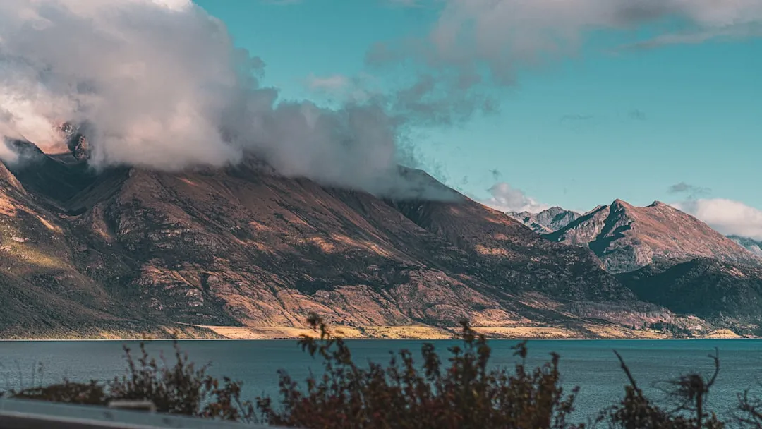
The ascent is characterised by a series of well-maintained switchbacks, designed to manage the significant elevation gain over a relatively short distance. As you climb, the forest canopy gradually thins, revealing glimpses of the surrounding peaks and valleys. The air becomes crisper, and the sounds of the forest give way to the whisper of the wind and the calls of alpine birds. The final section of the track opens onto a broad, gently undulating alpine plateau, culminating at Key Summit itself. From this vantage point, the views are simply spectacular. To the north, the imposing peaks of the Darran Mountains dominate the skyline, often capped with snow even in summer. To the south, the vast expanse of Fiordland stretches out, with views towards the Hollyford Valley and the distant Tasman Sea.
The track is particularly famous for its accessibility to such a dramatic alpine environment. Within a few hours, walkers can transition from sea-level rainforest to a high alpine plateau, experiencing a diverse range of ecosystems and geological features. The presence of glacial lakes, scree slopes, and exposed rock faces all contribute to the wild and untamed beauty of the area. It's a walk that demands a moderate level of fitness due to the steep climb, but the payoff in terms of scenery is immense, making it a must-do for many visiting Fiordland National Park.
History and Cultural Context
The area around Key Summit holds deep historical and cultural significance, intertwined with the journeys of both Māori and early European explorers. For Māori, particularly Ngāi Tahu, the valleys and mountain passes of Fiordland have been ancestral lands for centuries. These routes were vital for seasonal travel, hunting, and the procurement of resources, including the highly prized pounamu (greenstone). The passes and routes through this rugged terrain were challenging and required intimate knowledge of the land, its weather patterns, and its natural resources. The spiritual connection to this land is profound, and its significance is recognised within the Te Wāhipounamu South West New Zealand World Heritage Area designation.
The modern development of the Key Summit Track is closely linked to the construction of the Milford Road and the establishment of the Routeburn Track. The Milford Road itself, a marvel of engineering, was built to provide access to the iconic Milford Sound. The Divide, where the Key Summit Track begins, was a natural saddle point that became a crucial junction. The track itself is a section of the much longer Routeburn Track, one of New Zealand's Great Walks, which connects the Fiordland and Mount Aspiring National Parks. The Routeburn Track was first explored and documented by Europeans in the late 19th and early 20th centuries, with early surveyors and trampers charting routes through the challenging alpine terrain.
The Key Summit section, in particular, was developed to offer day visitors a taste of the Routeburn's alpine grandeur. Its accessibility from the Milford Road made it an ideal candidate for a well-maintained day walk. The track's construction involved careful grading and the use of local materials to minimise environmental impact while ensuring safety and accessibility. Today, it stands as a testament to the enduring appeal of Fiordland's wilderness, allowing a broad range of visitors to experience its dramatic alpine beauty, a beauty that has been appreciated and traversed by people for generations.
Seasonal Highlights and Weather Reality
The Key Summit Track is a year-round destination, but the experience varies significantly with the seasons. Its accessibility from the Milford Road means it's often one of the first alpine walks visitors can undertake upon arrival in Fiordland.
Spring (September–November): This season brings a sense of renewal to the landscape. Snowmelt begins to feed the streams, and alpine wildflowers start to emerge. While higher sections of the track may still hold snow, especially in early spring, the lower parts are generally clear. The weather can be unpredictable, with a mix of sunny days and cold, wet conditions. The surrounding mountains may still be snow-capped, offering dramatic contrasts.
Summer (December–February): This is the most popular time to walk the Key Summit Track. The days are longer, and the weather is generally more settled, although Fiordland is renowned for its rain at any time of year. The alpine meadows are at their most vibrant, with a profusion of alpine flowers. Sandflies can be prevalent during warmer months, so insect repellent is essential. The views from Key Summit are often at their clearest during this period, offering expansive panoramas.
Autumn (March–May): Autumn paints the Fiordland landscape in stunning hues of gold, red, and brown as the beech forests change colour. The air is crisp and clear, and the sandfly numbers typically decrease. Snow may begin to fall on the higher peaks in late autumn, adding a touch of winter's grandeur to the scenery. The weather can be more settled than in spring, but cold snaps are possible.
Winter (June–August): Winter transforms the Key Summit Track into an alpine environment that requires caution and appropriate gear. Snow and ice can cover the track, particularly on the higher sections and the summit plateau. While the lower forest sections may be clear, the upper reaches can be treacherous without ice axe and crampons, and experienced winter navigation skills. The views can be spectacular on clear winter days, with snow-covered peaks and a pristine white landscape, but the risk of severe weather, including blizzards, is high. Access to The Divide can also be affected by snow on the Milford Road.
Weather Reality: It is crucial to remember that Fiordland is one of the wettest regions in New Zealand, receiving an average of 6,500 mm of rainfall annually. The weather can change with extreme rapidity, especially at higher elevations. Even on a clear morning, fog, rain, and strong winds can descend quickly. Always be prepared for all conditions, regardless of the season.
Recommended Itinerary
Key Summit Day Walk Itinerary
Early Morning (Approx. 8:00 AM): Depart Te Anau
- Drive from Te Anau towards Milford Sound on State Highway 94 (Milford Road).
- The drive itself is scenic, passing through Fiordland National Park.
- Allow approximately 2 hours for the drive to The Divide.
Morning (Approx. 10:00 AM): Arrive at The Divide Trailhead
- Park at the designated car park at The Divide.
- This is the starting point for both the Key Summit Track and the Routeburn Track.
- Ensure you have your day pack ready with water, snacks, rain gear, and insect repellent.
Late Morning (Approx. 10:15 AM - 12:00 PM): Ascent to Key Summit
- Distance: 1.7 km (one way)
- Elevation Gain: 450 m
- Time: 1.5–2 hours (one way)
- Begin the steady climb on a well-formed track.
- The initial section winds through beautiful temperate rainforest, with moss-covered trees and ferns.
- As you gain altitude, the forest thins, and the views begin to open up.
- The track becomes steeper with well-constructed switchbacks.
- Pass through sub-alpine tussock fields and rocky outcrops.
Midday (Approx. 12:00 PM - 1:30 PM): Explore Key Summit
- Reach the summit plateau of Key Summit.
- Spend time enjoying the 360-degree panoramic views.
- Key viewpoints include the Darran Mountains to the north, the Hollyford Valley to the west, and the vast Fiordland wilderness to the south.
- Look for glacial lakes and evidence of past glaciation.
- Enjoy your packed lunch and take photographs.
- Be aware of rapidly changing weather conditions.
Afternoon (Approx. 1:30 PM - 3:30 PM): Descent and Return to The Divide
- Begin the descent back down the track.
- The descent is quicker but can be hard on the knees. Take your time.
- Re-enter the temperate rainforest.
- Arrive back at The Divide car park.
Late Afternoon (Approx. 3:30 PM onwards): Drive back to Te Anau
- Begin the scenic drive back to Te Anau.
- Consider stopping at viewpoints along the Milford Road, such as Mirror Lakes or the Homer Tunnel viewpoint.
Important Notes:
- This is a day walk; no overnight accommodation is required.
- The track is well-maintained but steep in sections.
- Weather can change very quickly; always be prepared for rain, wind, and cold, even in summer.
- Sandflies can be a nuisance, especially during warmer months; bring effective repellent.
- Allow ample time for the drive to and from The Divide.
Planning and Bookings
Book Your Trip
Everything you need to plan your journey
Accommodation
Find places to stay near Te Anau
Flights
Search flights to Te Anau
Essential Preparation
The Key Summit Track is a popular day walk, and while it doesn't require the extensive booking process of multi-day treks, proper preparation is still essential for a safe and enjoyable experience. The primary logistical consideration is access to the trailhead at The Divide, which is located on the Milford Road (SH94). This road is a significant tourist route, and its condition can be affected by weather, especially in winter. Ensure your vehicle is in good condition and that you have sufficient fuel, as services are limited between Te Anau and Milford Sound.
Te Anau is the closest town and serves as the main hub for visitors exploring Fiordland National Park. It offers a range of accommodation options, from budget-friendly hostels to comfortable hotels, as well as supermarkets for purchasing food and supplies, and outdoor gear shops for any last-minute purchases. It is advisable to base yourself in Te Anau before and after your visit to the Key Summit Track to allow for flexibility with weather and travel times.
Given the track's popularity and its location within a national park, it's important to be aware of the weather forecast. Fiordland is notorious for its unpredictable and often severe weather. Checking the MetService mountain forecast for the Fiordland region before you depart is highly recommended. Be prepared for rain, wind, and temperature drops, even on seemingly clear days.
Trail Accommodation
This is a day hike requiring no overnight accommodation.
Required Gear
- Sturdy Footwear: Waterproof hiking boots with good ankle support are essential. The track is well-formed but can be uneven and slippery, especially after rain.
- Waterproof Outerwear: A high-quality waterproof and windproof jacket and overtrousers are non-negotiable. Fiordland experiences frequent rainfall, and conditions can change rapidly.
- Warm Layers: Even in summer, temperatures at Key Summit can be cool due to the altitude and wind. Bring thermal base layers, a fleece or wool mid-layer, and a warm hat and gloves.
- Navigation: While the track is well-marked, a map of the area and a compass or GPS device are advisable, especially if you plan to explore off the main path (which is not recommended). An offline map app on your phone can also be useful.
- First-Aid Kit: A basic first-aid kit including blister treatment, pain relievers, antiseptic wipes, and any personal medications is crucial.
- Sun Protection: Sunglasses, sunscreen (SPF 50+), and a wide-brimmed hat are important, as the sun can be intense at higher altitudes, even on cloudy days.
- Head Torch: Essential in case of unexpected delays or if you start later in the day, especially during winter months when daylight hours are shorter. Ensure it has fresh batteries.
What to Bring
- Food and Water: Carry sufficient water for the duration of your walk (at least 1-2 litres per person). There are no water sources on the track that are guaranteed safe to drink without treatment. Pack high-energy snacks and a packed lunch.
- Insect Repellent: Sandflies are a significant issue in Fiordland, particularly during warmer months. Bring a strong repellent containing DEET (at least 20%) or Picaridin. Apply it liberally and reapply frequently.
- Backpack: A comfortable day pack (20-30 litres) to carry your gear. Ensure it has a rain cover.
- Trekking Poles: Optional, but can be very helpful for stability on the steep ascent and descent, and can reduce strain on your knees.
- Camera: To capture the stunning scenery.
- Mobile Phone: For emergencies, though reception is extremely limited or non-existent for most of the track.
- Small Towel: Useful for drying off after rain or for wiping down gear.
Permits
No permits or bookings are required to walk the Key Summit Track as it is a day walk accessible from the Milford Road. Access to The Divide car park is free. However, it is important to note that the Milford Road itself can be subject to closures due to weather events, particularly snow and ice in winter, or slips and flooding at any time of year. Always check the Waka Kotahi (NZ Transport Agency) website for current road conditions before you travel.
While no specific permit is needed for the Key Summit Track itself, visitors are expected to adhere to the Department of Conservation's (DOC) guidelines for national parks. This includes respecting the environment, staying on marked tracks, and practising Leave No Trace principles.
Important Considerations:
- Road Access: The Milford Road is a public highway, but its remote location and the challenging Fiordland environment mean it can be closed with little notice. Check road status before you leave Te Anau.
- Parking: The car park at The Divide can become very busy, especially during peak season. Arrive early to secure a parking spot.
- National Park Entry: Entry into Fiordland National Park is free.
Other Activities in the Area
The Key Summit Track is often undertaken as part of a larger trip to the Milford Sound region. There are numerous other activities and attractions to enhance your visit:
- Milford Sound: The ultimate destination on the Milford Road. Take a scenic cruise on the fiord to marvel at Mitre Peak, waterfalls, and wildlife like seals and dolphins. Kayaking and scenic flights are also popular options.
- Homer Tunnel: A historic, single-lane tunnel over 1.2 km long that provides access to the Cleddau Valley and the start of the Milford Road. It's a unique engineering feat.
- Mirror Lakes: A short, easy walk from the Milford Road to a series of small lakes that perfectly reflect the surrounding mountains on calm days.
- Lake Marian Track: A more challenging day hike (approx. 3 hours return) that leads to a stunning alpine lake nestled beneath towering peaks. This track also starts from the Milford Road.
- Hollyford Valley: Accessible via a gravel road off the Milford Road, this valley offers a more remote wilderness experience with various walking tracks and opportunities for jet boating.
- Te Anau: The gateway town to Fiordland, offering accommodation, dining, and the Te Anau Glowworm Caves.
- Routeburn Track: The Key Summit Track is a section of this famous Great Walk. If you have more time, consider walking a portion or the entirety of the Routeburn Track.
Safety and Conditions
Weather Preparedness: The most critical safety aspect for the Key Summit Track is being prepared for Fiordland's notoriously unpredictable weather. Conditions can change from sunny and calm to wet, windy, and cold within minutes. Always carry waterproof and windproof clothing, warm layers, and a hat and gloves, regardless of the forecast. Hypothermia is a real risk, even in summer.
Track Conditions: The track is generally well-maintained, but sections can be steep, rocky, and slippery, especially after rain. Wear sturdy, broken-in hiking boots with good grip. Be mindful of your footing, particularly on the descent.
Sandflies: Fiordland is famous for its sandflies, which are most active during warmer, calmer conditions. They are small but their bites can be intensely itchy and persistent. Use a strong insect repellent (containing DEET or Picaridin), cover exposed skin, and consider wearing a head net. They are often less active in windy conditions or during heavy rain.
Navigation: The Key Summit Track is well-marked and easy to follow. However, in poor visibility (fog or heavy rain), it is possible to lose your bearings, especially on the open summit plateau. Carry a map and compass or GPS device, and know how to use them. Do not venture off the marked track, especially in low visibility.
Emergencies: Mobile phone reception is unreliable to non-existent for most of the track. Consider carrying a personal locator beacon (PLB) or satellite phone for emergencies, especially if hiking alone or in adverse weather. Inform someone of your plans, including your expected return time.
Wildlife: While generally not a safety concern, be aware of the native birdlife. Kea, the world's only alpine parrot, are intelligent and curious and may approach visitors. Do not feed them, as it is harmful to their health and can lead to aggressive behaviour.
Road Safety: The Milford Road is winding and can be hazardous. Drive with caution, be aware of other traffic (including tour buses and campervans), and adhere to speed limits. Check road conditions before you travel.
Side Trips and Points of Interest
While the Key Summit Track itself is a relatively short walk, the journey to and from the summit offers several points of interest and opportunities for brief detours:
The Divide: The starting and ending point of the walk. This saddle is a significant geographical feature, marking the watershed between the Tasman Sea and the Pacific Ocean catchments. Interpretive signs here explain the area's history and ecology.
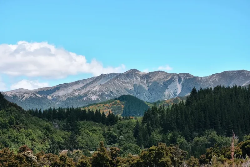
Forest Sections: The initial and final parts of the track wind through a beautiful temperate rainforest. Look for the lush undergrowth of ferns, mosses, and lichens that thrive in Fiordland's high rainfall. The towering beech trees create a cathedral-like atmosphere.
Alpine Flora: As you ascend above the treeline, you'll enter sub-alpine and alpine zones. Keep an eye out for hardy alpine plants and wildflowers that bloom in spring and summer, adapted to the harsh conditions.
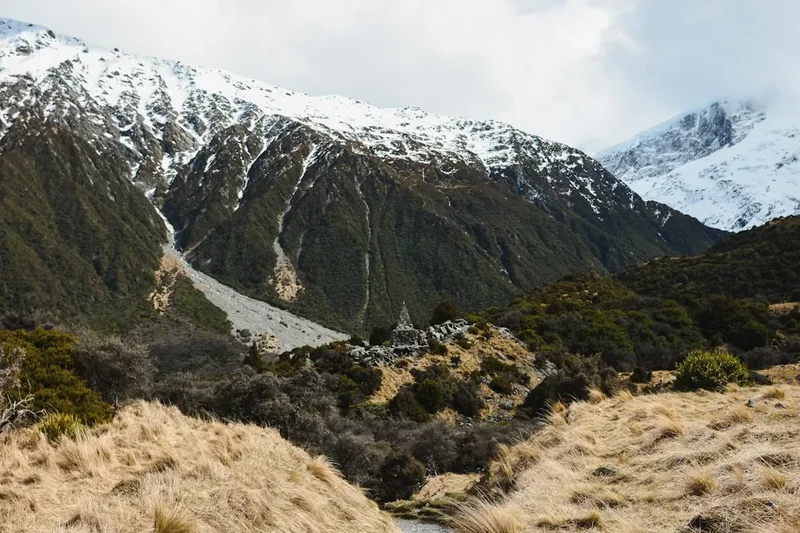
Glacial Features: The landscape around Key Summit is a testament to past glaciation. You can observe U-shaped valleys, cirques, and moraines that were carved out by massive glaciers thousands of years ago. The presence of small alpine tarns (small mountain lakes) is also a common feature.
Panoramic Views: The summit plateau itself is the main attraction. The 360-degree views are the primary "point of interest." On a clear day, you can see:
- Darran Mountains: A rugged range to the north, often snow-capped.
- Hollyford Valley: A vast, glacially carved valley stretching westwards.
- Fiordland Wilderness: An immense expanse of mountains, valleys, and rainforest stretching towards the horizon.
- Possible distant views of Milford Sound: On exceptionally clear days, the distant waters of Milford Sound might be visible.
Routeburn Track Junction: The Key Summit Track is a spur off the main Routeburn Track. You'll see signage indicating the junction, and if you have extra time and energy, you could walk a short distance along the Routeburn Track itself to experience more of its character.
Leave No Trace
The Key Summit Track, like all of Fiordland National Park, is a precious natural environment that requires careful stewardship. Practising Leave No Trace principles ensures that this beautiful area remains pristine for future generations and minimises our impact on its delicate ecosystems.
Plan Ahead and Prepare: Understand the weather conditions, pack appropriate gear, and know the route. This minimises the need for unexpected actions that could harm the environment.
Travel and Camp on Durable Surfaces: Stay on the marked track at all times. The vegetation, especially in alpine areas, is fragile and can take many years to recover if damaged. The track is designed to withstand foot traffic; straying off it can lead to erosion and habitat destruction.
Dispose of Waste Properly: Pack out everything you pack in. This includes all food scraps, wrappers, tissues, and any other litter. There are no bins on the track or at The Divide. Use the toilet facilities at The Divide if available, or if not, dig a cathole at least 70 metres away from water sources, trails, and campsites (though camping is not permitted on this day walk).
Leave What You Find: Do not remove any natural objects, such as rocks, plants, or flowers. Take only photographs and memories.
Minimise Campfire Impacts: Campfires are not permitted on this day walk, and are generally discouraged in Fiordland National Park due to the risk of wildfire and impact on vegetation.
Respect Wildlife: Observe wildlife from a distance. Do not feed any animals, including birds like the kea. Feeding them can alter their natural behaviour and diet, leading to health problems and dependency on humans.
Be Considerate of Other Visitors: Keep noise levels down, yield to other walkers on narrow sections of the track, and be respectful of the natural quiet of the area. The Key Summit Track is popular, so be prepared to encounter other people.