Kepler Track - A Journey Through the Clouds
The Kepler Track is one of New Zealand's premier Great Walks, offering a spectacular 60-kilometre loop through the heart of Fiordland National Park. Unlike many other multi-day hikes in the region that follow ancient Māori greenstone trails or pioneer exploration routes, the Kepler Track was custom-built for pleasure. Opened in 1988 to celebrate the centennial of the National Parks system and to alleviate pressure on the nearby Milford and Routeburn Tracks, it was designed to showcase the very best of Fiordland’s diverse landscapes. Over three to four days, walkers traverse vast tussock-covered alpine ridges, descend through lush podocarp and beech forests, and skirt the serene shores of Lake Te Anau and Lake Manapouri. It is a journey of immense scale, where the transition from the mossy, damp forest floor to the wind-swept limestone bluffs of the alpine zone happens with breathtaking speed.
- Distance: 60.0 km loop
- Duration: 3–4 days
- Season: Late October–April (Great Walks season; bookings mandatory)
- Huts: Luxmore Hut, Iris Burn Hut, Moturau Hut
- Campsites: Brod Bay, Iris Burn, Moturau
- Highest point: Mount Luxmore (1,472 m) / Track high point (1,400 m)
- Difficulty: Moderate (requires good fitness for the alpine ascent and descent)
- Direction: Can be walked in either direction, though clockwise is most common
Overview
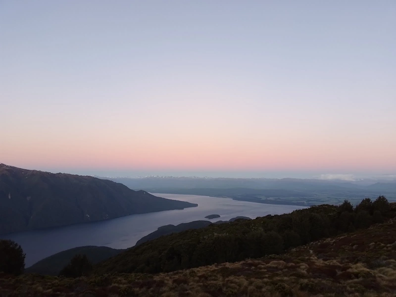
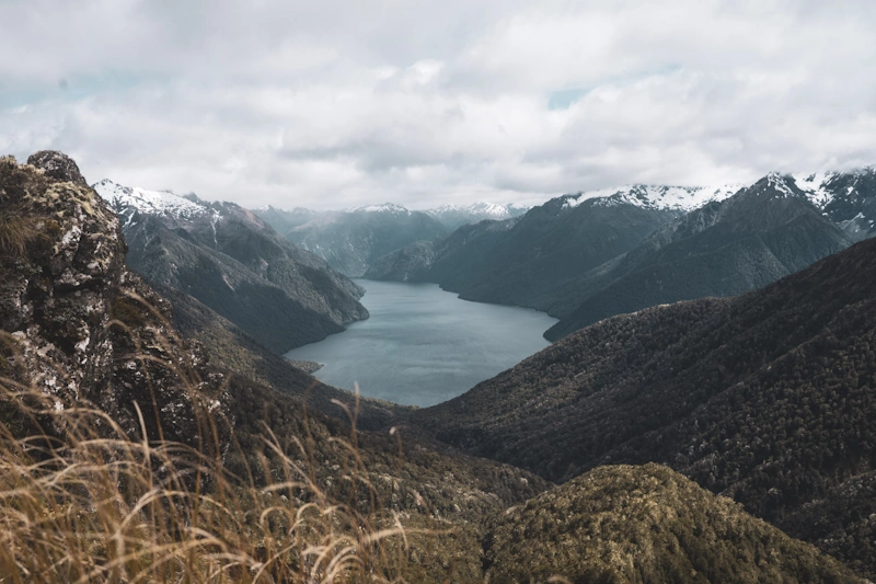
The Kepler Track is often described as the "wilderness loop," a title that reflects its unique geography. Starting and ending near the township of Te Anau, the track eliminates the logistical complexity of boat transfers or long shuttle rides required by its neighbours. However, do not let its accessibility fool you; the Kepler is a serious mountain undertaking. The track is a masterclass in landscape contrast. One moment you are enveloped in the prehistoric silence of a silver beech forest, where every branch is draped in emerald moss and the only sound is the high-pitched call of a rifleman. The next, you emerge above the bushline onto the exposed ridges of the Kepler Mountains, where the horizon expands to reveal the jagged, snow-capped peaks of the Murchison Mountains and the deep, glacial fiords of Lake Te Anau.
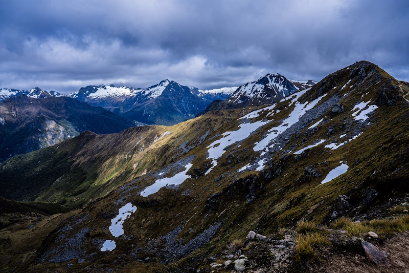
The physical heart of the journey is the traverse between Luxmore Hut and Iris Burn Hut. This section stays above the treeline for several kilometres, offering some of the most sustained alpine walking available on any Great Walk. On a clear day, the views are unparalleled, stretching across the vast expanse of the Te Wāhipounamu World Heritage Area. However, this exposure makes the Kepler particularly susceptible to Fiordland’s notoriously volatile weather. The ridge can be buffeted by gale-force winds and shrouded in cloud within minutes, transforming a scenic stroll into a test of endurance and navigation. This duality—the serene lakeside forests and the raw, unforgiving alpine heights—is what defines the Kepler experience.
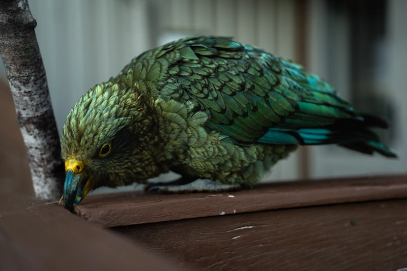
For many, the highlight is the descent into the Iris Burn Valley. After the intensity of the ridges, the track plunges back into the forest via a series of well-graded switchbacks. The change in temperature and humidity is immediate. The valley floor is a haven for New Zealand’s native birdlife, including the inquisitive and often mischievous kea, the world’s only alpine parrot. The final leg of the journey follows the Waiau River and the shores of Lake Manapouri, providing a gentle, meditative conclusion to a high-energy adventure. Whether you are watching the sunrise from the deck of Luxmore Hut or cooling your feet in the crystal-clear waters of Shallow Bay, the Kepler Track provides a profound sense of connection to the wild.
History and Cultural Context
The Kepler Mountains, which the track traverses, were named after the 17th-century German astronomer Johannes Kepler. While the track itself is a modern creation, the land it occupies has a deep and storied history. For Ngāi Tahu, the Māori iwi (tribe) of the South Island, the lakes and rivers of this region were vital sources of food and resources. Lake Te Anau (Te Ana-au, meaning "The Cave of Swirling Water") and Lake Manapouri (Moturau, meaning "Many Islands") were part of a network of seasonal trails used for gathering mahinga kai (traditional foods) and transporting pounamu (greenstone). The forests provided birds, eels, and plant materials, while the lakes offered a means of travel through an otherwise impenetrable landscape.
European exploration of the area began in the mid-19th century. Early surveyors and explorers, such as James McKerrow and Quintin MacKinnon, ventured into the valleys surrounding the Kepler range, but the high ridges remained largely untouched by formal trails for decades. It wasn't until the 1980s that the Department of Conservation (DOC) identified the need for a new Great Walk. The goal was to create a track that met modern tramping standards—wide paths, gentle gradients where possible, and high-quality hut facilities—while showcasing a variety of ecosystems. The construction was a significant engineering feat, involving the clearing of dense forest and the hand-cutting of paths through limestone outcrops and alpine scree.
Since its opening in 1988, the Kepler Track has become a cornerstone of New Zealand’s outdoor culture. It is also home to the "Kepler Challenge," a world-renowned mountain run held every December. Elite athletes complete the entire 60-kilometre loop in less than five hours—a staggering feat considering most trampers take four days. This event has cemented the track's reputation as a place of both physical challenge and immense natural beauty. Today, the track is managed with a strong focus on conservation, particularly the protection of the endangered whio (blue duck) in the Iris Burn stream and the control of introduced predators to ensure the survival of the local kiwi population.
Want more background? Read extended notes on history and cultural context → Learn more
Seasonal Highlights and Weather Reality
The Kepler Track experience is dictated entirely by the seasons. During the Great Walks season (late October to April), the track is fully operational. This is when the huts are staffed by DOC wardens, gas cooking facilities are provided, and the track is maintained to a high standard. Summer (December to February) offers the longest daylight hours and the warmest temperatures, with averages ranging from 10°C to 20°C in the valleys. However, this is also the period of highest rainfall and peak sandfly activity. In Fiordland, "summer" does not guarantee sunshine; trampers should be prepared for rain at any time.
The shoulder seasons of late October, November, and April are often considered the best times to walk. The air is crisper, the light is softer for photography, and the crowds are slightly thinner. However, the risk of snow on the high ridges increases significantly. It is not uncommon for the section between Luxmore and Iris Burn to be closed temporarily in November due to late-season snowfalls or high wind warnings. Walkers must be flexible with their plans during these months.
Outside the Great Walks season (May to October), the Kepler Track becomes a formidable alpine environment. The Department of Conservation removes many of the bridges to prevent damage from avalanches, and the huts operate on a "backcountry" basis with no gas or wardens. The alpine section is prone to severe avalanches, particularly in the gullies above the Iris Burn. Only those with advanced winter mountaineering skills, including the use of ice axes and crampons, and a deep understanding of avalanche terrain should attempt the full loop in winter. For most recreational walkers, winter visits are limited to day trips to Luxmore Hut (if conditions allow) or walks along the lakeside sections.
Recommended Itinerary
4-Day Kepler Track Loop (Clockwise)
Day 1: Kepler Track Control Gates to Luxmore Hut
- Distance: 13.8 km
- Elevation gain: 800 m
- Time: 5–6 hours
- Start at the Control Gates car park, a short drive or 50-minute walk from Te Anau.
- Follow the gentle lakeside path through beech forest to Brod Bay (campsite available).
- Begin the steady climb from Brod Bay up towards the limestone bluffs.
- Pass through spectacular limestone formations and towering cliffs.
- Emerge above the bushline for the first expansive views of Lake Te Anau and the Te Anau basin.
- Arrive at Luxmore Hut (1,085 m), situated on a scenic alpine meadow.
- Evening activity: Visit the Luxmore Caves, located a 10-minute walk from the hut (bring a head torch).
Day 2: Luxmore Hut to Iris Burn Hut
- Distance: 14.6 km
- Elevation: 200 m gain, 1,000 m descent
- Time: 5–6 hours
- The "Alpine Day" – highly exposed and weather-dependent.
- Climb from the hut towards the shoulder of Mount Luxmore.
- Optional side trip: 15-minute climb to the summit of Mount Luxmore (1,472 m) for 360-degree views.
- Traverse the spectacular ridge line between the Forest Burn and Hanging Valley shelters.
- Navigate the "Big Slip" area and descend via a long series of zigzags into the Iris Burn Valley.
- The descent is steep and demanding on the knees, dropping from the alpine zone back into dense forest.
- Arrive at Iris Burn Hut, located in a large clearing near the Iris Burn stream.
Day 3: Iris Burn Hut to Moturau Hut
- Distance: 16.2 km
- Elevation: 150 m descent (gradual)
- Time: 5–6 hours
- A steady, gentle descent through the Iris Burn Valley.
- Follow the river through mixed podocarp and beech forest.
- Pass the site of a massive 1984 landslide, now regenerating with pioneer species.
- The forest here is lush, with high biodiversity and frequent bird sightings.
- Reach the shores of Lake Manapouri and follow the coastline to Moturau Hut.
- Moturau Hut is situated on a beautiful sandy beach at Shallow Bay, perfect for a (cold) swim.
Day 4: Moturau Hut to Kepler Track Control Gates
- Distance: 15.5 km
- Elevation: Minimal (mostly flat)
- Time: 4–5 hours
- The final leg is a gentle walk through ancient forest and wetlands.
- Cross the suspension bridge over the Waiau River, which connects Lake Te Anau and Lake Manapouri.
- Pass through the Spirit Burn and over a large wetland area on a well-maintained boardwalk.
- Follow the terrace above the Waiau River back towards the starting point.
- Finish the loop at the Control Gates car park.
- Celebrate your achievement with a meal in Te Anau.
Important Notes:
- The track can be walked in 3 days by combining Day 3 and Day 4 (31.7 km total for the final day).
- Clockwise is recommended to get the major climb over on Day 1.
- Always check the weather forecast at the DOC Visitor Centre in Te Anau before starting Day 2.
- Water is available at all huts, but treatment is recommended.
- Sandflies are prevalent at Iris Burn and Moturau – keep hut doors closed.
Planning and Bookings
Book Your Trip
Everything you need to plan your journey
Accommodation
Find places to stay near Te Anau
Flights
Search flights to Te Anau
Essential Preparation
The Kepler Track requires significant physical preparation and logistical coordination. While the track is well-maintained, the 800-metre climb on Day 1 and the 1,000-metre descent on Day 2 are strenuous. Walkers should have experience carrying a multi-day pack (10–15 kg) over uneven terrain. Training hikes with elevation gain are highly recommended in the weeks leading up to the trip.
Te Anau is the essential base for this hike. It is a two-hour drive from Queenstown and serves as the gateway to Fiordland. The town has several supermarkets, outdoor gear shops for rentals (poles, stoves, waterproofs), and a wide range of accommodation. It is advisable to stay in Te Anau the night before your hike to attend a safety briefing at the DOC Visitor Centre and the night after to recover. Transport to the trailhead is simple: you can drive to the Control Gates (free parking), take a shuttle bus, or even take a water taxi from the Te Anau lakefront to Brod Bay to skip the first 5.6 km of flat walking.
Trail Accommodation
Accommodation on the Kepler Track consists of three Department of Conservation huts and two designated campsites (Brod Bay and Iris Burn). During the Great Walks season, these must be booked well in advance.
Hut Facilities:
- Luxmore Hut (54 bunks): Large, modern hut with incredible views. Features gas hobs, heating in the common area, cold running water, and flush toilets.
- Iris Burn Hut (50 bunks): Situated in a valley clearing. Features gas hobs, heating, cold water, and flush toilets. Known for its resident kea population.
- Moturau Hut (40 bunks): Located on the shores of Lake Manapouri. Features gas hobs, heating, cold water, and flush toilets.
- All huts provide mattresses on communal bunks. No bedding, pillows, or blankets are provided.
Campsite Facilities:
- Campsites at Brod Bay and Iris Burn provide a shelter for cooking, a water supply (untreated), and pit toilets.
- Campers must bring their own stoves and all camping equipment.
- Campers are not permitted to use the hut facilities (kitchen or common room).
Costs and Availability:
- Hut prices vary for NZ residents and international visitors. Expect to pay approximately NZ$70–$110 per night depending on status.
- Campsites are significantly cheaper, around NZ$20–$30 per night.
- Bookings usually open in May or June for the following summer season and sell out quickly, especially for the peak months of December and January.
Required Gear
- Footwear: Sturdy tramping boots with good ankle support and grip are essential for the rocky alpine sections. Ensure they are well broken-in.
- Waterproof Layers: A high-quality waterproof jacket (Gore-Tex or similar) with a hood is non-negotiable. Waterproof overtrousers are also highly recommended for the ridge traverse.
- Clothing: Use a layering system. Merino or synthetic base layers (no cotton), a warm fleece or down mid-layer, and quick-dry trousers or shorts.
- Pack: A 40–60 litre pack with a waterproof liner or rain cover.
- Sleeping Bag: A 3-season sleeping bag (rated to 0°C) is necessary as huts can get cold at night, even in summer.
- Safety: A basic first aid kit, a head torch with spare batteries, and a survival blanket.
- Navigation: While the track is well-marked, a physical map and compass (and the knowledge to use them) are essential for alpine conditions.
What to Bring
- Food: All food for the duration of the hike. Lightweight, high-calorie options like dehydrated meals, porridge, nuts, chocolate, and crackers are best. There is no food available for purchase on the track.
- Cooking Equipment: A lightweight pot, bowl, mug, and cutlery. Gas hobs are provided in huts, but campers need their own stove and fuel.
- Water Treatment: While hut water is generally safe, DOC recommends boiling, filtering, or chemically treating all water.
- Toiletries: Toothbrush, biodegradable soap, a small towel, and hand sanitiser.
- Sun and Bug Protection: High-SPF sunscreen, a sun hat, sunglasses, and strong insect repellent (DEET-based) for the sandflies.
- Personal Items: Earplugs (for communal bunkrooms), a camera, and a power bank (there are no charging outlets in the huts).
Permits
To walk the Kepler Track during the Great Walks season, your "permit" is effectively your hut or campsite booking confirmation. You must carry a printed or digital copy of this confirmation at all times, as hut wardens will check it every evening. There is no separate entry fee for the National Park itself.
Booking Process:
- Bookings are made through the Department of Conservation (DOC) website.
- You must create an account before the booking opening date.
- On opening day (usually in May), the system experiences extremely high traffic. It is recommended to be logged in and ready the moment bookings open.
- You must book each night individually as part of your itinerary.
Cancellations and Changes:
- DOC has a strict cancellation policy. Refunds are usually available if you cancel more than a few weeks in advance, but a fee is often retained.
- If the track is closed by DOC due to extreme weather or safety concerns, full refunds are typically issued for the affected nights.
Off-Season Permits:
- Outside the Great Walks season, no bookings are required. Instead, you must purchase Backcountry Hut Passes or Hut Tickets from a DOC Visitor Centre.
- Note that facilities are greatly reduced during this time, and the risk level is significantly higher.
Other Activities in the Area
Fiordland is a world-class destination with much more to offer than just the Kepler Track. Consider these activities to round out your trip:
- Te Anau Glowworm Caves: Take a boat trip across Lake Te Anau to explore a subterranean world of rushing water and thousands of glittering glowworms.
- Milford Sound / Piopiotahi: A two-hour drive from Te Anau, a cruise on Milford Sound is an essential Fiordland experience, featuring Mitre Peak and towering waterfalls.
- Doubtful Sound / Patea: For a more remote experience, take a day or overnight trip to Doubtful Sound, departing from Manapouri. It is three times longer and ten times larger than Milford Sound.
- Fiordland Cinema: Watch "Ata Whenua - Shadowland," a stunning 32-minute film showcasing the inaccessible wilderness of Fiordland from the air.
- Lake Manapouri: Often cited as New Zealand's most beautiful lake, it offers excellent kayaking and day-walking opportunities.
- Bird Watching: Visit the Punanga Manu o Te Anau / Te Anau Bird Sanctuary to see the rare, flightless takahē and other native birds.
Safety and Conditions
Safety in Fiordland is a matter of preparation and respect for the environment. The Kepler Track, while well-trodden, presents several specific hazards that walkers must manage.
Weather Extremes: Fiordland is one of the wettest places on Earth. Heavy rain can cause flash flooding, making even small streams dangerous to cross. On the alpine ridges, wind speeds can exceed 100 km/h, and temperatures can drop below freezing even in mid-summer. Hypothermia is a genuine risk. If the weather turns, the best advice is often to stay put in a hut or shelter rather than pushing onto the exposed ridges.
Alpine Exposure: The section between Luxmore Hut and the Hanging Valley Shelter is highly exposed. There is no shelter from wind or rain for several hours. If visibility is poor, stay on the marked track—the orange poles are your lifeline. Do not attempt to summit Mount Luxmore in high winds or thick cloud.
Avalanche Risk: From May to November, the Kepler Track is subject to avalanche danger. There are over 40 known avalanche paths that cross the track, particularly on the descent into Iris Burn. DOC monitors these risks during the season, but walkers must be self-reliant in the off-season.
Communication: Cell phone coverage is non-existent on most of the track, except for a few spots on the Luxmore ridge. It is highly recommended to carry a Personal Locator Beacon (PLB), which can be hired from the DOC Visitor Centre or outdoor shops in Te Anau. In an emergency, a PLB is the fastest way to alert search and rescue services.
Sandflies: While not a direct safety threat, sandflies can cause significant distress and allergic reactions. They are most active in damp, shaded areas and near water. Cover up and use repellent to avoid being bitten.
Side Trips and Points of Interest
The Kepler Track features several notable detours that enhance the experience:
Luxmore Caves: Located just a short walk from Luxmore Hut, these limestone caves are a fascinating geological feature. You can explore several hundred metres into the cave system. The passage is narrow and wet in places, so a good head torch and sturdy footwear are required. The caves feature delicate stalactites and stalagmites—please do not touch them as the oils from your skin can stop their growth.
Mount Luxmore Summit: While the main track skirts the shoulder of the mountain, a 15-minute side path leads to the actual summit (1,472 m). On a clear day, this is the ultimate viewpoint of the track, offering a 360-degree panorama that includes the Murchison Mountains, the Franklin Mountains, and the South Arm of Lake Te Anau.
Iris Burn Falls: A 20-minute walk from the Iris Burn Hut leads to a spectacular waterfall that plunges into a deep, cold pool. It is a peaceful spot to relax after the long descent from the ridges. The forest surrounding the falls is particularly lush and full of birdlife.
Shallow Bay: Near Moturau Hut, a short side track leads to Shallow Bay and a historic hunters' hut. The beach here offers a different perspective of Lake Manapouri and is often quieter than the main hut area.
Leave No Trace
As a visitor to Fiordland National Park, you have a responsibility to protect this pristine environment. The Kepler Track passes through sensitive alpine and forest ecosystems that can be easily damaged.
- Plan Ahead and Prepare: Ensure you have the right gear and skills to avoid emergencies that put rescuers at risk.
- Travel and Camp on Durable Surfaces: Stay on the formed track at all times. In the alpine zone, stepping off the track can crush fragile plants that take years to grow.
- Dispose of Waste Properly: Pack out everything you pack in. This includes food scraps, tea bags, and fruit peels, which do not decompose easily in this climate and can attract pests. Use the toilets provided at huts and shelters.
- Leave What You Find: Do not take rocks, plants, or historical artefacts. Leave the limestone formations in the caves untouched.
- Minimise Campfire Impacts: Fires are strictly prohibited on the Kepler Track. Use a portable stove for cooking.
- Respect Wildlife: Never feed the kea. Feeding them makes them dependent on humans and can lead to them eating dangerous materials like lead flashing or plastic. Store your gear inside the huts, as kea are known to destroy boots and packs left outside.
- Be Considerate of Others: Keep noise levels down in the huts and on the track to allow everyone to enjoy the natural sounds of the wilderness.