Kebnekaise Summit Trail
The Kebnekaise Summit Trail is Sweden's most iconic mountain trek, leading to the country's highest peak, Kebnekaise. This challenging route ascends through dramatic Arctic landscapes, offering a true test of endurance and a profound connection with the raw beauty of the Swedish Lapland. The trail is not for the faint-hearted, demanding significant physical fitness and mental fortitude. It winds through rugged terrain, past glacial streams, and across scree slopes, culminating in a steep, often snow-covered final ascent to the summit plateau. The reward for this arduous journey is an unparalleled panoramic view of the surrounding mountain ranges, a breathtaking vista that stretches across vast, wild expanses.
- Distance: 9.0 km (one-way from Kebnekaise Fjällstation to summit)
- Elevation gain: 1,800 m
- Duration: 10–12 hours (round trip)
- Difficulty: Challenging
- Best Time: July to September
- Closest City: Kiruna
- Trailhead Access: Nikkaluokta (requires 19 km hike or helicopter to Fjällstation)
- Permits: Not required for hiking, but registration at Fjällstation recommended
Overview
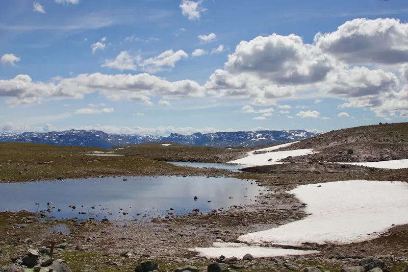
Kebnekaise, standing at 2,096 metres above sea level, is the highest mountain in Sweden and a pilgrimage destination for many outdoor enthusiasts. The summit trail is a demanding day hike that begins from the Kebnekaise Fjällstation (mountain station). The route is divided into two main sections: the initial ascent to the Kaffedalen valley, and the final, steeper climb to the summit plateau. The Kaffedalen section is rugged but generally well-trodden, featuring rocky paths and some stream crossings. As you gain altitude, the vegetation thins, giving way to more exposed, rocky terrain. The air becomes thinner, and the weather can change dramatically, often bringing strong winds, fog, or even snow, regardless of the season.
The final push to the summit is the most challenging part. It involves navigating steep scree slopes and, depending on the snow conditions, potentially using ice axe and crampons. The summit itself is a broad plateau, with two distinct peaks: the western summit (2,096 m), which is the highest and features a glacier, and the eastern summit (2,043 m), which is more accessible and often considered the "true" summit by hikers. The views from the top are spectacular, offering a sweeping panorama of the vast Kungsleden (King's Trail) region, with countless lakes, rivers, and mountain ranges stretching to the horizon. This is a true wilderness experience, far from the comforts of civilisation, demanding self-reliance and careful preparation.
The journey back down is often as challenging as the ascent, particularly for the knees, as the scree and rocky descents can be tiring. Hikers must be mindful of their energy levels and the changing light, especially if starting early or late in the day. The Kebnekaise Summit Trail is a significant undertaking, offering a profound sense of accomplishment and an unforgettable encounter with Sweden's wild Arctic heart.
History and Cultural Context
Kebnekaise has long held significance for the indigenous Sámi people, who have inhabited this region for centuries. The mountain, known as Giebmegáisi in Northern Sámi, is considered a sacred place and has been a part of their traditional lands for hunting and travel. The Sámi have a deep understanding of the land, its seasons, and its challenges, and their historical presence is woven into the fabric of the Kebnekaise massif.
The exploration and charting of Kebnekaise by Europeans began in the 19th century. Swedish geologists and explorers were drawn to the region, seeking to map its topography and understand its geological formations. The first recorded ascent of Kebnekaise was made in 1883 by a French expedition led by Charles Rabot. This marked a turning point, opening the mountain to a wider audience of adventurers and scientists. Following this, the Swedish Tourist Association (STF) began to develop infrastructure to support visitors, including the establishment of mountain huts and trails.
The Kebnekaise Fjällstation, a key starting point for summit attempts, was established to provide accommodation and services for hikers. Over the decades, it has grown into a significant hub for Arctic tourism. The development of the Kungsleden trail in the early 20th century further cemented the region's importance for trekking. Today, Kebnekaise remains a symbol of Swedish wilderness and a premier destination for mountaineering and hiking, attracting thousands of visitors each year who come to test themselves against its formidable heights and experience the unique beauty of the Arctic landscape.
Seasonal Highlights and Weather Reality
The hiking season for Kebnekaise is relatively short, typically from July to September. During this period, the snow cover on the lower and middle sections of the trail usually recedes, making them more accessible. However, the summit plateau and the final ascent can still hold snow and ice, even in mid-summer. This means that conditions can vary significantly from year to year and even day to day.
Summer (July–August): This is the most popular time to attempt the summit. The days are long, with the midnight sun casting an ethereal glow over the landscape. Temperatures can range from 5°C to 15°C at the Fjällstation, but will be considerably colder at higher altitudes, often dropping below freezing. Sandflies can be present, though generally less of a nuisance than in coastal areas. The main challenge is the unpredictable weather, which can shift from clear skies to fog, rain, or snow within minutes. The western summit's glacier is usually passable, but ice axe and crampons are often recommended or even essential.
Autumn (September): The autumn colours in the lower valleys can be spectacular, with birch and willow trees turning vibrant shades of yellow and red. However, the weather becomes more unpredictable, with a higher chance of snow and colder temperatures. Daylight hours decrease significantly. The trails can become icy, and the risk of encountering winter conditions on the summit increases. Many hikers choose to avoid September due to the increased risk and shorter days.
Outside the main season (October–June): Kebnekaise is an advanced alpine winter destination. The Fjällstation operates with reduced services, and the trails are covered in deep snow and ice. Ascending to the summit during this period requires significant mountaineering experience, specialised equipment (including skis or snowshoes, ice axe, crampons, and avalanche safety gear), and a thorough understanding of winter mountain conditions. It is strictly for experienced winter alpinists.
Recommended Itinerary
Kebnekaise Summit Day Hike Itinerary
Day 1: Arrival and Preparation at Kebnekaise Fjällstation
- Arrive at Nikkaluokta (via Kiruna airport and bus/taxi)
- Hike 19 km to Kebnekaise Fjällstation (approx. 4–5 hours) OR take a helicopter transfer (pre-booking essential)
- Check into accommodation at the Fjällstation or nearby campsite
- Attend the mandatory summit briefing at the Fjällstation (usually held in the evening)
- Review weather forecasts and trail conditions with Fjällstation staff
- Organise and pack your gear for the summit attempt
- Rest and hydrate well
Day 2: Summit Attempt (Kebnekaise Fjällstation to Summit and Return)
- Early Morning (e.g., 05:00–06:00):
- Early breakfast at the Fjällstation or a packed meal
- Final gear check and weather assessment
- Begin ascent from Kebnekaise Fjällstation (approx. 680 m elevation)
- Follow the well-marked trail towards Kaffedalen
- Initial section is rocky and can be uneven
- Morning (e.g., 08:00–10:00):
- Reach Kaffedalen (approx. 1,100 m elevation)
- This is a common resting point, often with a small shelter or cairn
- Begin the steeper ascent towards the summit plateau
- Terrain becomes more scree-covered and challenging
- Midday (e.g., 11:00–13:00):
- Continue climbing towards the summit ridge
- Depending on snow conditions, you may need to use an ice axe and crampons
- Navigate carefully across the rocky and potentially icy terrain
- The final approach to the summit plateau
- Afternoon (e.g., 13:00–15:00):
- Reach the summit plateau
- Ascend to the western summit (2,096 m) for the highest point, or the eastern summit (2,043 m) for easier access and views
- Enjoy the panoramic views (weather permitting)
- Take photos and celebrate your achievement
- Begin the descent from the summit
- Late Afternoon/Evening (e.g., 16:00–20:00):
- Descend carefully back through the scree and rocky sections
- Return to Kaffedalen
- Continue descent back to Kebnekaise Fjällstation
- Arrive back at the Fjällstation, tired but accomplished
- Dinner and rest
Important Notes:
- This is a demanding day hike requiring excellent fitness and preparation.
- Weather can change rapidly; always be prepared for cold, wind, rain, and snow.
- Carry sufficient food and water for the entire day.
- Inform the Fjällstation staff of your summit plans and expected return time.
- Consider hiring a guide if you are inexperienced or conditions are uncertain.
- The western summit has a glacier; ice axe and crampons are often necessary.
Planning and Bookings
Book Your Trip
Everything you need to plan your journey
Accommodation
Find places to stay near Kiruna
Flights
Search flights to Kiruna
Essential Preparation
The Kebnekaise Summit Trail is a serious undertaking that requires meticulous planning. The closest major city is Kiruna, which has an airport (KRN) and train connections. From Kiruna, you can take a bus or taxi to Nikkaluokta, a small village that serves as the gateway to Kebnekaise. The hike from Nikkaluokta to the Kebnekaise Fjällstation is approximately 19 km and takes about 4–5 hours. Alternatively, a helicopter transfer is available from Nikkaluokta to the Fjällstation, but this is expensive and must be booked well in advance. Limited parking is available at Nikkaluokta.
Accommodation at the Kebnekaise Fjällstation ranges from dormitory-style rooms to private cabins, and there is also a campsite. Booking accommodation at the Fjällstation is highly recommended, especially during the peak summer months. The Fjällstation also offers meals, equipment rental, and crucial information about trail conditions and weather forecasts. Attending the mandatory summit briefing at the Fjällstation is essential for anyone planning to ascend Kebnekaise; it provides vital safety information and updates on the mountain's status.
Trail Accommodation
The primary accommodation for hikers attempting the Kebnekaise summit is the Kebnekaise Fjällstation. This is a well-equipped mountain station operated by the Swedish Tourist Association (STF).
Fjällstation Facilities:
- Dormitory-style rooms with bunk beds (sleeping bags required)
- Private rooms (limited availability, book well in advance)
- Restaurant and café serving meals and snacks
- Shop selling essential supplies, snacks, and some gear
- Sauna
- Drying rooms for wet clothing
- Toilets and showers
- Information desk with weather forecasts and trail condition updates
- Equipment rental (ice axes, crampons, poles, etc.)
Campsite: Adjacent to the Fjällstation, there is a campsite for those who prefer to pitch their own tent. Facilities are shared with the Fjällstation.
Booking Requirements:
- Accommodation at the Fjällstation and campsite should be booked in advance, especially during July and August.
- Bookings can be made through the STF website.
- Members of STF receive discounted rates.
What's NOT Provided:
- Food is available for purchase at the restaurant, but self-catering is common.
- Sleeping bags and linens are required for dormitory rooms.
- Cooking equipment is not provided in rooms; use designated areas or the campsite.
Seasonal Availability: The Fjällstation is typically open from late June to mid-September. Outside these dates, services are significantly reduced, and the mountain is considered winter terrain.
Costs: Prices vary depending on the type of accommodation and whether you are an STF member. Expect to pay approximately 500–1000 SEK per person per night for a dormitory bed, and more for private rooms. Camping fees are lower.
Note: This is a day hike requiring no overnight accommodation on the trail itself, as the ascent and descent are typically completed within a single day from the Fjällstation.
Required Gear
- Sturdy hiking boots - waterproof, with good ankle support and a well-worn sole.
- Waterproof and windproof jacket - Gore-Tex or similar, with a hood.
- Waterproof and windproof overtrousers - essential for protection against rain and wind.
- Warm layers - including a fleece or down jacket, and thermal base layers (merino wool is ideal).
- Hat and gloves - even in summer, the summit can be very cold.
- Backpack - 30-45 litre capacity, with a rain cover.
- Head torch - with spare batteries, for early starts or late finishes.
- First-aid kit - including blister treatment, pain relievers, bandages, and any personal medications.
- Navigation tools - map of the area, compass, and a GPS device or smartphone with offline maps. Knowledge of how to use them is crucial.
- Ice axe and crampons - essential for the western summit, especially outside of peak summer or if snow/ice is present. Check conditions at the Fjällstation.
- Trekking poles - highly recommended for stability on ascents and descents, especially on scree.
What to Bring
- Food and snacks - high-energy, easy-to-eat items like energy bars, nuts, dried fruit, sandwiches. Pack more than you think you'll need.
- Water bottles or hydration reservoir - at least 2 litres per person. Water sources are available but should be treated.
- Water treatment - filter or purification tablets.
- Sun protection - high SPF sunscreen, sunglasses, and a wide-brimmed hat. The sun can be intense at altitude, even on cloudy days.
- Toiletries - toothbrush, toothpaste, biodegradable soap, hand sanitiser.
- Personal items - camera, power bank for electronics, book for downtime.
- Cash - for purchases at the Fjällstation or for emergency use.
- Emergency shelter - a lightweight bivvy bag or emergency blanket.
Permits
No specific permits are required to hike the Kebnekaise Summit Trail. The trail is part of the public domain in Sweden, and access to the mountain is generally free. However, it is strongly recommended that all hikers register their summit plans with the staff at the Kebnekaise Fjällstation before setting out. This allows the Fjällstation to be aware of who is on the mountain and to initiate search and rescue operations if necessary.
Registration at Kebnekaise Fjällstation:
- This is a mandatory step for anyone planning to ascend Kebnekaise.
- The Fjällstation provides essential information on current weather conditions, trail status, and any specific hazards.
- You will be asked to provide your planned route, estimated return time, and contact information.
- This service is crucial for your safety and for the effectiveness of any potential rescue efforts.
Accommodation and Services: While no permit is needed for hiking, you will need to book and pay for accommodation at the Kebnekaise Fjällstation or campsite if you plan to stay there before or after your summit attempt. Services such as meals, equipment rental, and guided tours also incur costs.
Helicopter Transfers: If you opt for a helicopter transfer from Nikkaluokta to the Fjällstation, this is a paid service and requires advance booking. The cost is significant and varies depending on the operator and demand.
Other Activities in the Area
Beyond the challenging summit ascent, the Kebnekaise region offers a wealth of other activities for nature lovers and adventurers:
- Kungsleden Trail: Kebnekaise is a key point on the famous Kungsleden (King's Trail), one of Sweden's most popular long-distance hiking routes. You can explore sections of the Kungsleden, enjoying the vast wilderness and staying in STF mountain huts along the way.
- Day Hikes to Lower Peaks: For those seeking less strenuous but still rewarding hikes, there are numerous trails around the Fjällstation that lead to smaller peaks and scenic viewpoints, such as the hike to the STF Singi mountain hut or exploring the valleys surrounding Kebnekaise.
- Sámi Culture: Visit the nearby village of Nikkaluokta or explore cultural centres in Kiruna to learn about the indigenous Sámi people, their traditions, reindeer herding, and unique way of life.
- Kiruna: The city of Kiruna itself is worth exploring. It is undergoing a major relocation due to iron ore mining and offers unique sights, including the modern city centre and the historic Kiruna Church.
- Abisko National Park: A short train ride from Kiruna, Abisko National Park is renowned for its stunning natural beauty, including the Aurora Sky Station for viewing the Northern Lights (in winter) and excellent hiking opportunities.
- Icehotel in Jukkasjärvi: During the winter months, the world-famous Icehotel offers a unique accommodation experience, carved entirely from ice and snow.
- Fishing and Canoeing: The numerous lakes and rivers in the region offer opportunities for fishing and canoeing during the summer months.
Safety and Conditions
Pre-Trip Planning:
- Weather: The most critical factor. Check the STF mountain forecast and the Swedish Meteorological and Hydrological Institute (SMHI) for Kebnekaise and surrounding areas. Be prepared for rapid changes, including fog, strong winds, rain, sleet, and snow, even in July and August.
- Trail Conditions: Obtain the latest information on trail conditions from the Kebnekaise Fjällstation staff. They will advise on snow cover, ice, and any hazards on the summit route.
- Fitness: The summit hike is strenuous, involving significant elevation gain (1,800 m) over a relatively short distance. Ensure you have a high level of cardiovascular fitness and leg strength.
- Equipment: Ensure all your gear is in good condition and appropriate for Arctic mountain conditions. Test your head torch and ensure you have spare batteries.
On the Mountain:
- Navigation: Always carry a map, compass, and GPS device, and know how to use them. Visibility can drop to zero quickly in fog or snow.
- Ice Axe and Crampons: For the western summit, these are often essential. Do not attempt the glacier without them and the knowledge to use them safely.
- Hypothermia: The risk is real, even in summer. Dress in layers, avoid cotton, and change out of wet clothing as soon as possible. Stay hydrated and eat regularly.
- Dehydration and Fatigue: Carry ample water and high-energy food. Pace yourself and take breaks.
- Communication: Mobile phone reception is unreliable on the mountain. Consider carrying a personal locator beacon (PLB) or satellite phone for emergencies. Inform the Fjällstation of your plans and expected return time.
- Respect the Mountain: Do not take unnecessary risks. If conditions deteriorate or you are unsure, turn back. The mountain will still be there another day.
- Wildlife: While rare, you might encounter Arctic foxes or reindeer. Keep a safe distance and do not feed any animals.
Emergency Contact: In case of emergency, contact the Kebnekaise Fjällstation or the Swedish emergency services (112).
Side Trips and Points of Interest
Kaffedalen Valley: This is a crucial waypoint on the ascent to Kebnekaise's summit. Located at approximately 1,100 metres, it marks the transition from the more gentle lower slopes to the steeper, more challenging terrain leading to the summit plateau. Kaffedalen offers a natural resting spot, and often a small shelter or cairn provides a brief respite from the elements. The views from Kaffedalen looking back down the valley are already impressive, offering a sense of the scale of the landscape you are traversing.
Kebnekaise Glacier (Western Summit): The highest point in Sweden is crowned by a glacier. While the glacier itself is not a vast ice field, it presents a significant challenge and requires proper mountaineering equipment (ice axe and crampons) and skills to navigate safely. The glacier's condition can vary greatly depending on the season and recent weather, making it a dynamic and potentially hazardous part of the summit route. The views from the western summit are considered the most expansive.
Eastern Summit (2,043 m): While slightly lower than the western summit, the eastern peak is often considered the more accessible and "official" summit by many hikers. It is typically reached via a less technical route from the western summit or directly from the approach path. The eastern summit offers excellent panoramic views and is a popular spot for hikers to reach their goal without needing to tackle the glacier.
Vast Arctic Panoramas: The primary "point of interest" on any Kebnekaise summit attempt is the breathtaking 360-degree view from the top. On a clear day, you can see for hundreds of kilometres, with a seemingly endless expanse of mountains, valleys, lakes, and rivers stretching out in every direction. This is the heart of Swedish Lapland, a wild and remote landscape that offers a profound sense of scale and solitude.
The Kungsleden Trail: Kebnekaise Fjällstation is a significant stop on the Kungsleden. Even if you are not undertaking the entire trail, exploring short sections of the Kungsleden around Kebnekaise offers a taste of this iconic long-distance route and allows you to experience the surrounding wilderness at a more leisurely pace.
Leave No Trace
The Kebnekaise massif and the surrounding Arctic wilderness are fragile ecosystems that require the utmost respect from visitors. Adhering to Leave No Trace principles is paramount to preserving this pristine environment for future generations.
Your responsibility as a hiker:
- Plan Ahead and Prepare: Understand the terrain, weather, and regulations. Pack appropriately and be prepared for self-sufficiency.
- Travel and Camp on Durable Surfaces: Stick to marked trails to avoid damaging vegetation. When camping (if permitted outside designated areas), use established sites or durable surfaces like rock or gravel.
- Dispose of Waste Properly: Pack out everything you pack in, including all food scraps, wrappers, and toilet paper. Use designated toilets at the Fjällstation and other huts. If no facilities are available, dig catholes at least 70 metres from water sources, trails, and campsites.
- Leave What You Find: Do not remove rocks, plants, or any natural or cultural objects. Take only photographs and memories.
- Minimise Campfire Impacts: Campfires are generally discouraged and often prohibited in sensitive Arctic environments. Use a portable stove for cooking. If a fire is permitted and necessary, use established fire rings and keep fires small. Ensure fires are completely extinguished.
- Respect Wildlife: Observe wildlife from a distance. Never feed animals, as this can disrupt their natural behaviours and diets, and can be harmful to their health.
- Be Considerate of Other Visitors: Respect the solitude and natural quiet of the wilderness. Avoid loud noises and be courteous to fellow hikers.
The Kebnekaise region is a place of immense natural beauty and cultural significance. By practising Leave No Trace principles, you help ensure that this wild landscape remains unspoiled and accessible for all.