
Cozia Peak Trail - Romania's Carpathian Gem
The Cozia Peak Trail is a challenging yet immensely rewarding day hike located in the heart of Romania's Southern Carpathians, within the Cozia National Park. This trail offers a spectacular ascent through diverse forest ecosystems, culminating in breathtaking panoramic views from the summit of Cozia Peak. It's a journey that tests your endurance, rewards you with stunning natural beauty, and provides a deep connection with the wilder side of Romania. The trail winds through ancient woodlands, past dramatic rock formations, and opens up to expansive vistas of the Olt River Valley and the surrounding mountain ranges. This is a hike for those seeking a substantial physical challenge and an unforgettable alpine experience in a less-travelled European destination.
- Distance: 14.0 km one-way
- Elevation gain: 1100 m
- Duration: 6-8 hours
- Difficulty: Challenging
- Best Time: June to September (summer and early autumn), dry conditions
- Closest City: Călimănești
- Trailhead Access: Nearest airport: Bucharest (OTP). Take a train or bus to Călimănești, then a taxi to the trail start near the Cozia Monastery. Road is paved but narrow in sections. Parking available near the monastery. No permits needed, but check local conditions.
- Coordinates: 45.3517, 24.3822
Overview
The Cozia Peak Trail is a significant undertaking, designed for experienced hikers with a good level of fitness. The ascent is relentless, gaining over 1100 metres of elevation in just 14 kilometres. This means the gradient is consistently steep, demanding sustained effort. The trail begins its journey near the historic Cozia Monastery, a significant cultural landmark, and quickly plunges into the dense, ancient forests that cloak the lower slopes of the Southern Carpathians. As you climb, the character of the forest changes, transitioning from deciduous trees to more resilient conifers, reflecting the increasing altitude.
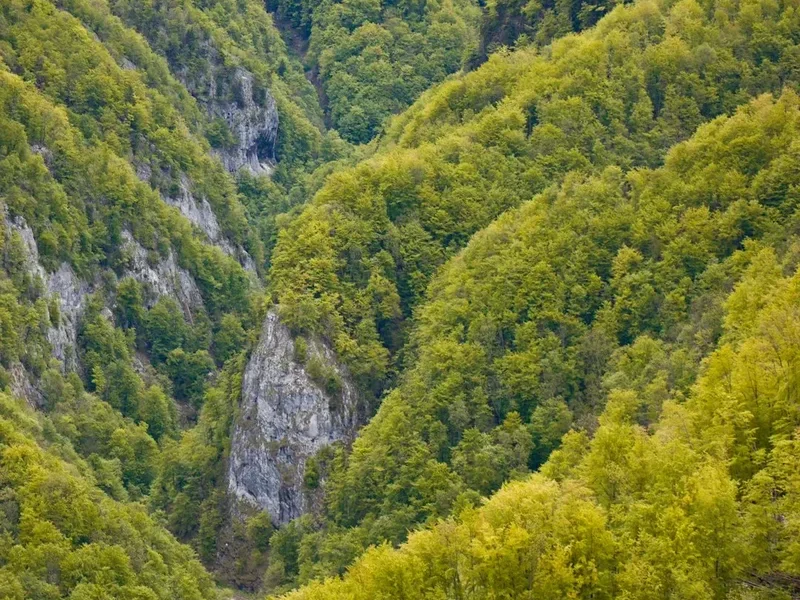
The path itself is varied. In places, it's a well-trodden dirt track, while in others, it becomes rocky and more rugged, requiring careful foot placement. You'll navigate through shaded ravines, cross small streams, and pass by intriguing rock formations that hint at the geological forces that shaped this landscape. The air grows cooler and fresher with every metre gained, and the sounds of civilisation fade, replaced by the rustling of leaves, the calls of birds, and the distant murmur of the Olt River far below.
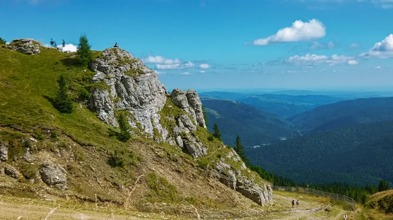
The true reward of the Cozia Peak Trail is the summit. Emerging from the treeline, the landscape opens up dramatically. Cozia Peak, at approximately 1668 metres, offers a commanding 360-degree panorama. To the west, the mighty Olt River carves its way through a dramatic gorge, a silver ribbon winding through the rugged terrain. To the east and south, the vast expanse of the Southern Carpathians unfolds, a sea of undulating peaks and valleys stretching as far as the eye can see. On a clear day, the views are simply breathtaking, providing a profound sense of accomplishment and a deep appreciation for the wild beauty of Romania.
This trail is not just a physical challenge; it's an immersion into a rich natural and historical environment. The combination of demanding terrain, stunning alpine scenery, and the proximity to cultural heritage sites makes the Cozia Peak Trail a standout destination for serious hikers.
History and Cultural Context
The region surrounding Cozia Peak has a long and rich history, deeply intertwined with the natural landscape. The Olt River Valley has served as a vital corridor for centuries, facilitating trade and travel through the Carpathian Mountains. The presence of the Cozia Monastery, founded in the 14th century by Mircea the Elder, a prominent ruler of Wallachia, underscores the historical significance of this area. The monastery, perched strategically overlooking the Olt River, has been a centre of religious and cultural life for over six centuries, surviving numerous conflicts and periods of change.
The mountains themselves have historically been a source of resources and a natural barrier. Local communities have long relied on the forests for timber, game, and medicinal plants. The rugged terrain also provided refuge and served as a natural defence. While the Cozia Peak Trail itself may not have a long, documented history as a formal hiking route in the same vein as some of the world's most famous treks, the paths and routes through these mountains have been used by shepherds, hunters, and travellers for generations. These ancient pathways, often marked by natural features or rudimentary signs, form the basis of many modern trails, including the route to Cozia Peak.
In more recent times, the establishment of Cozia National Park in 1966 aimed to protect the unique biodiversity and geological features of the area. This designation has helped preserve the natural integrity of the landscape, ensuring that trails like the Cozia Peak route can be enjoyed by hikers while maintaining their wild character. The park encompasses a diverse range of habitats, from the riparian ecosystems along the Olt River to the high-altitude alpine meadows and forests of the peaks. The trail thus offers a journey not only through a challenging physical landscape but also through layers of human history and natural preservation efforts.
Seasonal Highlights and Weather Reality
The Cozia Peak Trail is best experienced during the warmer months, from June to September. This period offers the most favourable weather conditions for a challenging mountain hike.
Summer (June to August): This is the peak season for hiking in the Carpathians. Days are generally long and warm, with temperatures at lower elevations often reaching 20-25°C. The forests are lush and green, and wildflowers are in bloom, adding vibrant colour to the landscape. However, summer in the mountains can also bring unpredictable thunderstorms, particularly in the afternoons. These storms can develop rapidly, bringing heavy rain, strong winds, and a significant drop in temperature. It is crucial to be prepared for sudden weather changes.
Early Autumn (September): This is often considered the ideal time to hike the Cozia Peak Trail. The summer crowds have thinned, the air is crisp and clear, and the forests begin to display stunning autumnal colours, with shades of gold, red, and orange painting the slopes. Temperatures are cooler, making the strenuous climb more comfortable, though early mornings and evenings can be chilly. Snowfall is unlikely at this altitude until late October or November, but frost is possible.
Late Autumn and Winter (October to May): Hiking the Cozia Peak Trail during these months is generally not recommended for casual hikers. Snowfall can begin as early as October, making the trail treacherous and potentially impassable, especially at higher elevations. Ice can form on rocky sections, and visibility can be severely reduced by fog or snow. Winter conditions require advanced mountaineering skills, appropriate equipment (crampons, ice axe), and a thorough understanding of avalanche risks. The trail is often covered in snow, and navigation can be extremely difficult.
Spring (May): While spring can be beautiful, it is also a transitional period. Lower elevations may be clear of snow, but higher sections of the trail can still hold significant snowpack well into May. Melting snow can lead to muddy and waterlogged conditions, and streams can be swollen and difficult to cross. The weather can be highly variable, with a mix of sunny days and late snow showers.
Weather Considerations: Regardless of the season, always check the local weather forecast before setting out. Mountain weather is notoriously unpredictable. Be prepared for a wide range of conditions, including sun, rain, wind, and potentially even hail or sleet, even in summer. Layering clothing is essential.
Recommended Itinerary
Cozia Peak Trail - Day Hike Itinerary
Early Morning (Approx. 7:00 AM - 8:00 AM): Arrival and Preparation
- Arrive in Călimănești.
- Travel to the vicinity of Cozia Monastery.
- Locate the trailhead, which is typically well-marked near the monastery or accessible via a short drive/walk from its parking area.
- Final gear check: ensure water bottles are full, snacks are accessible, and all safety equipment is in order.
- Briefly visit Cozia Monastery if time permits and you are interested in its history and architecture.
Morning (Approx. 8:00 AM - 12:00 PM): Ascent through Forested Slopes
- Begin the hike from the trailhead.
- The initial section involves a steady climb through dense deciduous and mixed forests.
- Follow marked trails, paying attention to signage.
- The path will gradually steepen, transitioning from a wide track to a narrower, more rugged trail.
- Enjoy the cool, shaded environment and the sounds of the forest.
- Keep an eye out for diverse flora and fauna.
- The elevation gain will be significant during this period.
Midday (Approx. 12:00 PM - 1:30 PM): Reaching Higher Altitudes and Lunch Break
- The forest may begin to change, with more coniferous trees appearing as you gain altitude.
- The trail may become rockier and more exposed in sections.
- Find a suitable, safe spot for a well-deserved lunch break, ideally with a partial view if available.
- Rehydrate and refuel for the remaining ascent.
- Assess your energy levels and the weather conditions.
Afternoon (Approx. 1:30 PM - 4:00 PM): Summit Push and Panoramic Views
- Continue the ascent towards Cozia Peak.
- The treeline may start to break, offering glimpses of the surrounding landscape.
- The final push to the summit can be steep and demanding.
- Arrive at Cozia Peak (approx. 1668 m).
- Spend time at the summit, taking in the spectacular 360-degree panoramic views of the Olt River Valley and the Southern Carpathians.
- Take photographs and appreciate the accomplishment.
Late Afternoon (Approx. 4:00 PM - 7:00 PM): Descent and Return
- Begin the descent back towards the trailhead.
- The descent can be as challenging as the ascent, requiring careful footing on loose or rocky terrain.
- Maintain a steady pace and be mindful of your knees.
- The return journey through the forest offers a different perspective in the changing light.
- Arrive back at the trailhead near Cozia Monastery.
- Allow for potential delays due to weather or fatigue.
Important Notes:
- This is a strenuous day hike; ensure you have adequate fitness.
- Carry sufficient water and high-energy food.
- Wear sturdy hiking boots and appropriate layered clothing.
- Always check the weather forecast before you go.
- The trail is marked, but carrying a map and compass or GPS device is advisable.
- Be aware of potential wildlife encounters.
Planning and Bookings
Book Your Trip
Everything you need to plan your journey
Accommodation
Find places to stay near Călimănești
Flights
Search flights to Călimănești
Essential Preparation
The Cozia Peak Trail is a demanding day hike that requires careful planning to ensure a safe and enjoyable experience. Given its challenging nature, physical fitness is paramount. Hikers should be accustomed to sustained uphill climbs and possess good stamina. It is advisable to have prior experience with mountain hiking and navigating varied terrain. Before embarking on the hike, it's essential to check the weather forecast for the Cozia Mountains region, as conditions can change rapidly. Ensure you have a reliable way to reach the trailhead near Cozia Monastery; while public transport can get you to Călimănești, a taxi or pre-arranged transport is often necessary for the final leg to the monastery and the start of the trail. Parking is available near the monastery, but it can be busy, especially during peak tourist seasons or religious holidays. Familiarise yourself with the route using maps or GPS devices, as while the trail is generally marked, remote sections can be less clear. Inform someone of your hiking plans, including your intended route and estimated return time.
Trail Accommodation
This is a day hike requiring no overnight accommodation.
Required Gear
- Sturdy Hiking Boots: Waterproof, with good ankle support and a well-worn sole for grip on rocky and uneven terrain.
- Backpack: A comfortable daypack (20-35 litres) to carry essentials.
- Waterproof Jacket: Essential for protection against rain and wind. Look for breathable materials.
- Waterproof Overtrousers: To keep dry during unexpected downpours.
- Warm Layers: Including a fleece or insulated jacket, and a base layer made of merino wool or synthetic material. Temperatures can drop significantly at higher altitudes.
- Headwear: A warm hat or beanie for cooler temperatures and a sun hat or cap for protection from the sun.
- Gloves: Lightweight gloves can be useful for cooler mornings or windy conditions.
- Navigation Tools: A physical map of the Cozia National Park, a compass, and a GPS device or smartphone with offline maps downloaded. Ensure your device is fully charged and consider a portable power bank.
- First Aid Kit: Comprehensive kit including blister treatment, bandages, antiseptic wipes, pain relievers, and any personal medications.
- Head Torch: With spare batteries, in case of unexpected delays or early starts/late finishes.
- Sun Protection: High SPF sunscreen, sunglasses.
What to Bring
- Food: High-energy snacks (nuts, dried fruit, energy bars), sandwiches, and a packed lunch. Ensure you have enough for the entire duration of the hike, plus a little extra in case of delays.
- Water: Carry at least 2-3 litres of water per person. Water sources may be available along the trail, but purification (filter or tablets) is strongly recommended if you plan to refill.
- Toiletries: Biodegradable soap, toothbrush and toothpaste, hand sanitiser, and toilet paper. Pack out all used toilet paper.
- Personal Items: Mobile phone (for emergencies, though signal may be intermittent), camera, identification, and a small amount of cash for any unexpected needs.
- Trekking Poles: Highly recommended for reducing strain on knees during the steep ascent and descent.
- Insect Repellent: Especially important during warmer months to ward off biting insects.
- Whistle: For emergency signalling.
Permits
For the Cozia Peak Trail, no specific permits are generally required for day hiking within Cozia National Park. The park is accessible to the public for recreational purposes. However, it is always advisable to check for any local regulations or temporary restrictions that may be in place before your visit. Information can often be found through the park administration or local tourism offices in Călimănești. While no booking system exists for this day hike, it is wise to be aware of any special events or religious observances at Cozia Monastery that might affect access or parking on your planned hiking day.
Other Activities in the Area
The region around Călimănești and Cozia National Park offers a variety of activities to complement your hiking adventure:
- Visit Cozia Monastery: Explore this historic and architecturally significant monastery, a spiritual and cultural heart of the region. Its serene atmosphere and beautiful frescoes are well worth a visit.
- Olt River Valley Exploration: Drive or cycle along the scenic Olt River Valley. The road offers dramatic views of the gorge and the surrounding mountains.
- Călimănești-Căciulata Spa Towns: These towns are renowned for their mineral springs and therapeutic waters. You can visit local spas for relaxation and wellness treatments.
- Hiking in Cozia National Park: Beyond the Cozia Peak Trail, the park offers numerous other marked trails of varying difficulty, exploring different valleys, peaks, and natural attractions.
- Explore the Olt Gorge: While the main trail ascends Cozia Peak, the Olt River itself carves a spectacular gorge. Scenic viewpoints along the road offer glimpses into its dramatic beauty.
- Local Cuisine: Sample traditional Romanian dishes at local restaurants in Călimănești or nearby villages. Look for hearty stews, grilled meats, and local cheeses.
- Photography: The landscapes, the monastery, and the river valley provide ample opportunities for stunning photography, especially during sunrise and sunset.
Safety and Conditions
Pre-Departure Checks:
- Weather Forecast: Always check the most up-to-date weather forecast for the Cozia Mountains region. Mountain weather can change rapidly, with sudden storms, fog, and temperature drops being common. MetService or local Romanian meteorological services are good resources.
- Trail Conditions: While generally well-maintained, sections of the trail can become slippery after rain or muddy in spring. Check with local park authorities or tourism offices in Călimănești for any recent trail updates or closures.
- Road Access: Ensure the road leading to Cozia Monastery is accessible. In rare cases, adverse weather or local events might cause temporary disruptions.
- Inform Someone: Let a trusted friend or family member know your hiking plans, including your intended route, start time, and estimated return time. Provide them with contact details for local emergency services.
Trail Hazards:
- Steep Terrain: The trail is consistently steep, requiring good physical condition and careful footing. Descending can be particularly hard on the knees.
- Uneven Surfaces: Expect rocky sections, roots, and loose scree, especially as you gain altitude.
- Weather Changes: Be prepared for sudden shifts in weather, including rain, wind, and fog, which can significantly reduce visibility and increase the risk of hypothermia.
- Wildlife: While large predators like bears are rare on this specific trail, be aware of your surroundings. Smaller wildlife, including snakes, can be present. Make noise as you hike to avoid surprising animals.
- Navigation: Although marked, the trail can be less distinct in certain sections, especially in poor visibility. Always carry and know how to use a map and compass or GPS device.
Emergency Procedures:
- Emergency Services: In Romania, the emergency number is 112. Be prepared to provide your exact location, the nature of the emergency, and your contact details.
- First Aid: Know basic first aid and be prepared to administer it if necessary.
- Signalling: Use a whistle (three short blasts) to signal for help if you are lost or injured.
General Safety Tips:
- Hike with a companion if possible.
- Carry a fully charged mobile phone, but do not rely on signal coverage.
- Stay on marked trails to avoid getting lost and to protect the environment.
- Pace yourself and take regular breaks.
- Do not attempt the hike in adverse weather conditions.
Side Trips and Points of Interest
Cozia Monastery: While not a side trip in the traditional sense, a visit to the historic Cozia Monastery is a must. Founded in 1386 by Mircea the Elder, it is one of the most important monastic settlements in Romania. Its architecture, frescoes, and serene atmosphere offer a significant cultural counterpoint to the natural challenge of the hike. The monastery is located very close to the trailhead, making it an ideal starting or ending point for your day.
Olt River Valley Viewpoints: As you ascend, and particularly from the summit, you will be treated to spectacular views of the Olt River Valley. The river has carved a dramatic gorge through the mountains, and the road that follows it is a scenic route in itself. The trail offers various points where you can pause and admire the vastness of the valley, the winding river, and the distant mountain ranges. These viewpoints are particularly stunning in the morning light or during the golden hour before sunset.
Forest Ecosystems: The trail passes through diverse forest types, from deciduous woodlands lower down to mixed and coniferous forests at higher altitudes. Observing the changes in vegetation, the types of trees, the undergrowth, and the associated flora and fauna provides an enriching experience. Look for native species of trees like beech, fir, and spruce, and keep an eye out for various bird species and smaller mammals.
Geological Formations: The Southern Carpathians are a geologically rich area. While not explicitly marked as points of interest on this trail, keep an eye out for interesting rock formations, outcrops, and the general topography that speaks to the ancient geological history of the region. The sheer scale of the mountains and the way they have been shaped by erosion and tectonic activity is a constant point of interest.
Leave No Trace
The Cozia Peak Trail traverses a beautiful and ecologically sensitive area within Cozia National Park. Adhering to Leave No Trace principles is crucial to preserving this natural environment for future visitors and for the health of the ecosystem.
Your responsibility as a hiker:
- Plan Ahead and Prepare: Understand the trail's difficulty, check weather forecasts, and pack appropriately. Inform someone of your plans.
- Travel and Camp on Durable Surfaces: Stay on the marked trail at all times. Avoid cutting switchbacks or walking on fragile vegetation, which can take years to recover.
- Dispose of Waste Properly: Pack out everything you pack in. This includes all food scraps, wrappers, and any other litter. Use designated toilet facilities if available, or dig a cathole at least 60 metres away from water sources, trails, and campsites if necessary (though this is a day hike, so waste disposal is primarily about packing out).
- Leave What You Find: Do not remove plants, rocks, or any other natural objects from the park. Take only photographs and memories.
- Minimise Campfire Impacts: Not applicable for this day hike, but a general principle for backcountry travel.
- Respect Wildlife: Observe wildlife from a distance. Never feed animals, as it can harm their health, alter their natural behaviours, and expose them to danger. Make noise while hiking to avoid surprising animals.
- Be Considerate of Other Visitors: Keep noise levels down, yield to uphill hikers, and maintain a respectful attitude towards fellow hikers and the natural environment.
By following these principles, you help ensure that the Cozia Peak Trail remains a pristine and enjoyable experience for everyone.