Kawah Ijen Crater Hike - The Electric Blue Flame of Java
The Kawah Ijen Crater Hike is one of the most otherworldly trekking experiences on Earth, located within the Ijen Volcano Complex in East Java, Indonesia. This is not merely a walk to a summit; it is a midnight pilgrimage into a volcanic caldera that houses the world’s largest highly acidic crater lake and the rare phenomenon of "Blue Fire"—electric blue flames ignited by sulphuric gases emerging from the earth at temperatures up to 600 degrees Celsius. The trail ascends through ancient montane forests and barren volcanic ridges, culminating at a rim that overlooks a turquoise-coloured lake with a pH level near zero. Beyond the geological marvels, the hike offers a profound encounter with the human spirit, as local sulphur miners traverse the same steep paths, carrying loads of up to 90 kilograms on their shoulders. This 6.0-kilometre return journey is a sensory assault of pungent smells, dramatic temperature shifts, and visual spectacles that feel more like a lunar expedition than a terrestrial hike.
- Distance: 6.0 km return
- Elevation Gain: 740 m
- Duration: 3–4 hours (total walking time)
- Difficulty: Challenging (steep gradients and volcanic fumes)
- Highest Point: 2,386 m (Crater Rim)
- Best Time: April to October (Dry Season)
- Key Features: Blue Fire, Acidic Crater Lake, Sulphur Mining, Sunrise Views
Overview
Kawah Ijen is part of a larger group of stratovolcanoes in the Ijen complex, a massive caldera approximately 20 kilometres wide. The hike itself is a concentrated burst of physical exertion and environmental drama. Starting at the Paltuding base camp (1,600 m), the trail climbs relentlessly for approximately 3 kilometres to reach the crater rim (2,386 m). The first two-thirds of the ascent are particularly steep, with gradients reaching 25 to 30 degrees, testing the endurance of even fit hikers. As the forest thins, the air cools significantly, and the smell of sulphur begins to permeate the atmosphere, signalling your proximity to the active solfatara.
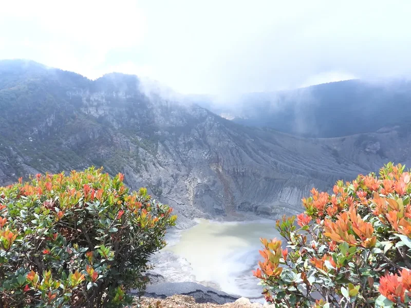
The experience is defined by its timing. Most hikers begin their journey at 2:00 AM to reach the crater floor under the cover of darkness. This is the only time the famous Blue Fire is visible—a chemical reaction where high-pressure sulphuric gases ignite upon contact with the oxygen-rich air. Once the sun rises, the blue flames vanish, replaced by the sight of the massive turquoise lake, which spans roughly 1 kilometre in diameter. The lake’s striking colour is a result of its extreme acidity and high concentration of dissolved metals. Surrounding the lake are the yellow, crystalline deposits of sulphur, where miners work in a landscape that looks like a scene from a dystopian film. The contrast between the harsh, industrial reality of the mining and the ethereal beauty of the sunrise over the Raung and Merapi volcanoes is what makes Kawah Ijen a bucket-list destination for travellers worldwide.
While the distance is relatively short, the combination of steep terrain, loose volcanic scree, and the necessity of wearing a respirator mask to filter toxic fumes makes this a "Challenging" walk. It requires careful preparation, respect for the local workers, and an appreciation for the volatile power of Indonesian geology.
History and Cultural Context
The Ijen volcanic complex has been active for hundreds of thousands of years, but its modern history is inextricably linked to the extraction of "Devil’s Gold"—elemental sulphur. The mining operations at Kawah Ijen began in earnest during the Dutch colonial era in the late 19th and early 20th centuries. The Dutch recognised the value of the high-purity sulphur found within the crater, which was used for everything from vulcanising rubber to manufacturing gunpowder and bleaching sugar. Unlike many modern mines that use heavy machinery, the extraction at Ijen remains one of the last manual sulphur mining operations in the world.
For the local Javanese and Madurese communities, the volcano is more than a geological hazard; it is a primary source of income. The miners, known as "penambang belerang," perform one of the most dangerous jobs on the planet. They descend into the crater, break the solidified sulphur into chunks, and load them into bamboo baskets (pikul). These men then carry these loads—often weighing between 70 and 90 kilograms—back up the steep crater walls and down the mountain to the weighing station at Paltuding. This cycle is repeated twice a day, often without the protection of gas masks, relying instead on wet cloths held between their teeth. The cultural fabric of the region is deeply influenced by this industry, and the miners are respected figures in their villages for their incredible physical strength and resilience.
In recent decades, Kawah Ijen has transitioned from a purely industrial site to a major tourism hub. This shift has created a complex dynamic where tourism provides a secondary income for miners—many of whom now act as guides or offer "trolley" services for tourists—while also bringing global attention to the harsh working conditions. The volcano is also a site of spiritual significance; local communities occasionally perform ceremonies and offerings to the mountain spirits to ensure safety and a bountiful harvest of sulphur, blending Islamic traditions with older animist beliefs common in East Java.
Want more background? Read extended notes on history and cultural context → Learn more
Seasonal Highlights and Weather Reality
The climate at Kawah Ijen is tropical but heavily influenced by its high altitude. There are two distinct seasons that dictate the hiking experience: the dry season and the wet season.
Dry Season (April to October): This is the optimal time to visit. The skies are generally clear, providing the best visibility for the Blue Fire and the sunrise. The trail is drier and less slippery, making the steep ascent and the descent into the crater safer. However, this is also the peak tourist season, particularly in July and August, meaning the trail can become extremely crowded. Temperatures at the base camp can drop to 5–10 degrees Celsius at night, and even lower at the rim, so warm layers are essential despite Indonesia's tropical reputation.
Wet Season (November to March): Hiking during the rainy season is possible but comes with significant challenges. Heavy afternoon downpours are common, and the trail can become a muddy, slippery mess. Fog and low cloud cover often obscure the views of the lake and the surrounding volcanoes. More importantly, the Blue Fire is harder to see if the vents are dampened by rain. There is also an increased risk of landslides on the road to Paltuding and within the crater itself. If you choose to hike during this time, a flexible schedule is required to wait for a clear weather window.
Weather Reality: Regardless of the season, the weather at the summit is unpredictable. Wind can whip up toxic sulphur clouds, forcing hikers to retreat or wait for the air to clear. The temperature difference between the start of the hike (midnight) and the return (mid-morning) can be as much as 20 degrees Celsius. Always check the local volcanic activity reports (PVMBG), as the park is frequently closed if gas emissions reach dangerous levels or if seismic activity increases.
Recommended Itinerary

The Midnight Expedition Itinerary
Phase 1: The Midnight Ascent (Paltuding to the Rim)
- Distance: 3 km
- Elevation gain: 740 m
- Time: 1.5–2 hours
- Start at Paltuding base camp between 01:30 and 02:00 AM
- The first 2 km are the most demanding, featuring a wide but steep dirt track through the forest
- Pass the "Canteen" (Warung) at the halfway point—a common place to rest and regroup
- The final 1 km to the rim flattens out slightly as the vegetation disappears, replaced by volcanic rock
- The air temperature will drop significantly; use this time to add layers before reaching the exposed rim
Phase 2: The Descent for Blue Fire (Rim to Crater Floor)
- Distance: 800 m (steep descent)
- Elevation loss: ~150 m
- Time: 30–45 minutes
- This section is optional and requires extreme caution; the path is narrow, rocky, and shared with miners
- Respirator masks MUST be worn from this point forward as sulphur gas concentrations are high
- Observe the Blue Fire from a safe distance—do not approach the active vents
- Watch the miners at work, breaking sulphur near the liquid gas vents
- Ensure you begin your ascent back to the rim before 05:00 AM to catch the sunrise
Phase 3: Sunrise and the Acid Lake (The Rim Exploration)
- Distance: 1–2 km (walking along the rim)
- Time: 1–1.5 hours
- Find a vantage point on the eastern side of the rim for the best sunrise views
- As the light increases, the turquoise colour of the acid lake becomes visible
- Walk further along the rim toward the "Instagram Tree" or the highest point for panoramic views of Mount Raung and Mount Merapi
- This is the best time for photography as the morning light hits the steam rising from the lake
Phase 4: The Return Journey (Rim to Paltuding)
- Distance: 3 km
- Elevation loss: 740 m
- Time: 1 hour
- The descent is fast but can be hard on the knees due to the steep gradient
- Enjoy the views of the lush Javanese landscape that were hidden in the darkness during the ascent
- Pass the miners heading down with their heavy loads; always give them the right of way
- Arrive back at Paltuding for a well-earned breakfast at the local stalls
Important Notes:
- The descent into the crater is technically prohibited by some park regulations but widely practiced; check current local status upon arrival
- Gas masks are mandatory for the crater descent and highly recommended for the rim
- Flashlights or headlamps are essential for the night hike
- The trail is one-way up and one-way down, but the path is wide enough for two-way traffic
- Always yield to sulphur miners; they are working and carrying immense weight
Planning and Bookings
Book Your Trip
Everything you need to plan your journey
Accommodation
Find places to stay near Banyuwangi
Flights
Search flights to Banyuwangi
Essential Preparation
Planning a trip to Kawah Ijen requires coordinating transport, equipment, and health requirements. The closest major city is Banyuwangi, which is well-connected by train from Surabaya or by ferry from Bali (Gilimanuk). Most hikers base themselves in Banyuwangi or the nearby village of Licin. You should arrange your transport to the Paltuding trailhead (the start of the hike) in advance, as it is a 1.5 to 2-hour drive on winding, steep roads. Many visitors opt for an organised tour which includes transport, a guide, and gas mask rental, but it is entirely possible to do the hike independently if you have your own transport (scooter or private car).
A critical recent requirement is the Health Certificate. As of 2024, many visitors are required to present a basic medical certificate stating they are fit for physical exercise. These can be obtained easily at local clinics (Puskesmas) in Banyuwangi for a small fee. Additionally, ensure you have downloaded the "Ijen Smart" app or checked the official BKSDA East Java website for the latest booking procedures, as they occasionally implement an online registration system to manage visitor numbers.
Trail Accommodation
Since the Kawah Ijen hike is typically a midnight-to-morning excursion, most people do not stay "on" the trail. However, there are several options for those who want to be close to the action:
Paltuding Base Camp:
- Campsite: There is a basic camping ground at the trailhead. You must bring your own tent and cold-weather sleeping gear. Facilities are limited to basic toilets and small food stalls (warungs).
- Guesthouses: A few very basic, government-run rooms are available at Paltuding. They are often fully booked and offer minimal amenities (no hot water, basic beds).
Licin Village and Surroundings (20–30 minutes from trailhead):
- This area offers mid-range to luxury eco-resorts and homestays. It is a popular choice for those who want a comfortable bed before the midnight start.
- Facilities usually include hot showers, Wi-Fi, and restaurants.
Banyuwangi City (1.5–2 hours from trailhead):
- A wide range of accommodation from budget backpacker hostels to 4-star hotels.
- Best for those who want to explore the city, visit local markets, or catch the train/ferry the next day.
Required Gear
- Respirator Gas Mask: This is non-negotiable. A standard N95 mask is insufficient for the concentrated sulphur dioxide fumes. You need a mask with chemical filters (typically 3M or similar). These can be rented at Paltuding for approximately 50,000 IDR.
- Headlamp: Essential for the midnight ascent and the rocky descent into the crater. Handheld torches are less ideal as you need your hands free for balance.
- Sturdy Footwear: Hiking boots with good grip are preferred, though trail runners are acceptable. The path into the crater is loose and slippery.
- Warm Layers: A windproof jacket, fleece, and thermal base layer. Temperatures at the rim can hover around 5°C before sunrise.
- Gloves and Beanie: To protect against the biting wind at the summit.
- Eye Protection: Clear goggles can be helpful if the wind blows sulphur smoke toward your face, as the gas can sting the eyes.
What to Bring
- Water: At least 1.5–2 litres per person. The air is dry and the climb is dehydrating.
- Snacks: High-energy food like bananas, chocolate, or energy bars. There are warungs at the base and halfway point, but they may not be open at 2:00 AM.
- Cash: Indonesian Rupiah (IDR) for the entrance fee, gas mask rental, and tips for guides or miners. There are no ATMs at Paltuding.
- Tissues/Wet Wipes: To clean your face and mask after the hike.
- Small Backpack: 15–20L is sufficient for your gear and water.
- Personal Medications: Especially if you have asthma or respiratory sensitivities (though individuals with severe asthma are advised against this hike).
- Camera/Smartphone: With spare batteries, as the cold can drain them quickly.
Permits
Access to Kawah Ijen is managed by the BKSDA (Balai Konservasi Sumber Daya Alam) of East Java. Unlike some of the more complex permit systems in New Zealand or the US, getting into Ijen is relatively straightforward, but there are specific rules to follow.
Entrance Fees (Subject to change):
- International Visitors: 100,000 IDR (weekdays) / 150,000 IDR (weekends and public holidays).
- Domestic Visitors: 5,000 IDR (weekdays) / 7,500 IDR (weekends).
- Camera Fee: Occasionally, a small fee is charged for professional DSLR cameras, though smartphones are usually exempt.
Booking Process:
- Tickets can be purchased directly at the Paltuding entrance gate upon arrival.
- During peak periods, the park may implement an online booking system via their official website or a dedicated app. It is wise to check the "Ijen Smart" app or local news a few days before your trip.
- The park typically opens at 02:00 AM, though this can change to 01:00 AM or even midnight depending on current volcanic activity and visitor demand.
Health Certificate: As mentioned in the planning section, a medical certificate is currently a mandatory "permit" of sorts. You must show a physical or digital copy of a doctor's note stating you are in good health. This is a response to previous incidents of respiratory distress among hikers.
Closures: The park closes on the first Friday of every month for "Ijen Libur" (Ijen Holiday) to allow the ecosystem to rest and for local authorities to conduct maintenance. Additionally, the park will close without notice if the PVMBG (Volcanology Agency) raises the alert level above "Normal."
Other Activities in the Area
East Java is a region of immense natural beauty. If you are visiting Kawah Ijen, consider these nearby attractions:
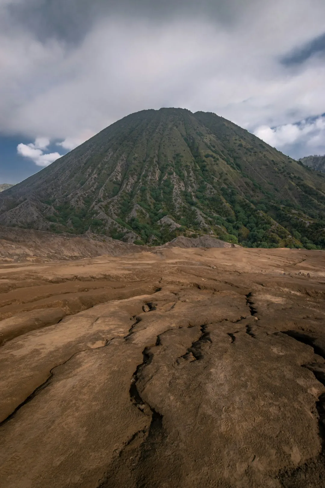
- Mount Bromo: The most famous volcano in Indonesia. Most travellers combine Ijen and Bromo into a 3-day tour. Bromo offers a vast "Sea of Sand" and an active smoking crater that is much easier to access than Ijen.
- Baluran National Park: Known as the "Africa of Java," this park features a vast savannah where you can see wild banteng (bulls), peacocks, and macaques against the backdrop of Mount Baluran.
- Sukamade Beach: Part of Meru Betiri National Park, this is a remote beach where green sea turtles come to lay their eggs at night. It requires a 4WD and a stay in basic jungle lodges.
- Jagir Waterfall: Located near Licin village, this is a beautiful, easily accessible waterfall where you can swim in cool, clear water—perfect for relaxing your muscles after the Ijen hike.
- Coffee Plantations: The Ijen plateau is famous for its Arabica coffee. Many plantations offer tours where you can see the process from bean to cup and taste the local brew.
- Banyuwangi Boom Beach: A black sand beach in the city with views of Bali across the strait, great for a sunset walk and local street food.
Safety and Conditions
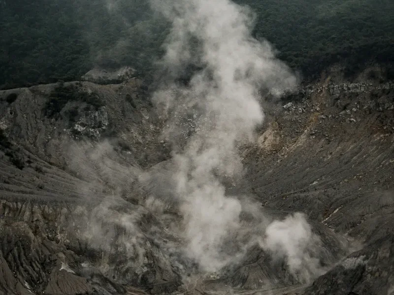
Respiratory Hazards: The primary danger at Kawah Ijen is the inhalation of sulphur dioxide (SO2) gas. When concentrated, this gas reacts with the moisture in your lungs and throat to form sulphuric acid, causing immediate coughing, choking, and long-term respiratory damage. Never enter the crater without a professional gas mask. If the wind shifts and you are engulfed in a gas cloud, stay calm, crouch low to the ground (the gas is often slightly lighter than air or moves in plumes), and breathe through your mask. If you feel dizzy or nauseous, retreat to the rim immediately.
Terrain and Physicality: The path into the crater is not a "trail" in the traditional sense; it is a steep, rocky scramble used by miners. The rocks can be loose and slippery with condensed sulphur. Wear shoes with excellent traction and use a headlamp to keep your hands free. The ascent to the rim is physically taxing; if you have heart conditions or severe asthma, you should not attempt this hike.
The "Trolley" Service: Local miners offer a service where they pull tourists up the mountain in their sulphur trolleys for a fee (usually 600,000–800,000 IDR). While this provides income for the miners, be aware that it is a strenuous task for them and can be a bumpy, uncomfortable ride for you. It is best used only if you find yourself physically unable to continue.
Volcanic Activity: Ijen is an active volcano. It is monitored 24/7 by the Indonesian authorities. Always follow the instructions of the park rangers. If the "Blue Fire" area is closed due to high gas activity, do not attempt to sneak past the barriers. The lake itself is also dangerous; the water is hot and acidic enough to dissolve metal and cause severe chemical burns. Stay well away from the water's edge.
Temperature Regulation: Hypothermia is a real risk while waiting for sunrise at the rim. The combination of sweat from the climb and the cold mountain wind can drop your core temperature quickly. Bring a dry change of shirt for the summit and keep your windbreaker on.
Side Trips and Points of Interest
The Blue Fire: This is the main draw for the midnight hike. It is not actually "lava" but the combustion of sulphuric gases. The flames can reach up to 5 metres in height. It is one of only two places in the world where this can be seen regularly (the other being in Iceland). The best time to view it is between 02:00 AM and 04:00 AM.
The Acid Lake: Once the sun rises, the lake is the star of the show. It is the largest highly acidic lake in the world. The turquoise colour is beautiful but deceptive; the pH is roughly 0.5, similar to car battery acid. The lake is approximately 200 metres deep and contains an estimated 36 million cubic metres of acidic water.
The Sulphur Vents (Solfatara): Located at the edge of the lake, these vents are where the gas is channeled through ceramic pipes to condense into liquid sulphur. As it cools, it hardens into bright yellow crystals. This is the heart of the mining operation and the source of the intense smells and sights of the crater.
The "Instagram Tree": A dead, gnarled tree on the rim that has become a famous photo spot. It offers a dramatic foreground for photos of the crater lake and the rising sun. Be careful near the edges, as the ground can be unstable.
Mount Merapi (East Java): Not to be confused with the famous Merapi near Yogyakarta, this dormant peak sits adjacent to Ijen and provides a stunning backdrop for the sunrise. The view from the Ijen rim allows you to see the shadow of Ijen cast across the landscape toward Merapi.
Leave No Trace
Kawah Ijen is a fragile volcanic ecosystem and a place of intense manual labour. Respecting the environment and the people is paramount.
Guidelines for Responsible Hiking:
- Pack Out All Trash: There is no waste management on the mountain. Every plastic bottle, cigarette butt, and snack wrapper you bring must come back down with you.
- Respect the Miners: This is their workplace. Always give them the right of way on the path. Do not block their way to take photos. If you wish to take a photo of a miner, ask for permission first. Many hikers choose to give a small tip or offer a cigarette/snack as a gesture of thanks.
- Do Not Buy Sulphur Carvings: Miners often sell small turtles or hearts carved from sulphur. While it seems like a good way to support them, these items are fragile, cannot be taken on planes (they are flammable), and encourage the further degradation of the crater. It is better to give a direct tip.
- Stay on the Path: The volcanic soil is prone to erosion. Straying from the main track can cause mini-landslides and damage the sparse high-altitude vegetation.
- No Graffiti: Do not carve names into the rocks or the few trees at the summit.
- Use Toilets at the Base: There are no facilities on the trail. Ensure you use the toilets at Paltuding before starting the hike.