Karakoram Highway Trek - The Eighth Wonder of the World
The Karakoram Highway (KKH) Trek is one of the most ambitious long-distance pedestrian expeditions on the planet, spanning approximately 1,200 kilometres across the rugged heart of the Karakoram, Himalaya, and Hindu Kush mountain ranges. Often referred to as the "Eighth Wonder of the World" due to the staggering engineering required for its construction, the route follows the ancient Silk Road, connecting the lush plains of Pakistan with the high-altitude plateaus of Western China. This is not a traditional wilderness trail but a monumental journey of endurance that traverses the deepest valleys on Earth, skirts the base of 8,000-metre peaks, and culminates at the Khunjerab Pass—the highest paved international border crossing in the world at 4,693 metres. Walking the KKH is a profound immersion into the geological raw power of the collision between the Indian and Eurasian tectonic plates, offering a perspective on scale that few other journeys can provide.
- Distance: 1,200.0 km (total Pakistani section)
- Duration: 45–60 days
- Season: May to October (high passes are snow-bound in winter)
- Accommodation: Local guesthouses, roadside dhabas, and wild camping
- Highest point: Khunjerab Pass (4,693 m)
- Difficulty: Challenging (due to distance, altitude, and extreme temperature fluctuations)
- Direction: South to North (Islamabad/Jaglot to Khunjerab Pass)
Overview
The Karakoram Highway Trek is a journey defined by verticality and contrast. Starting from the lower reaches of the Indus River, the route ascends through the arid, sun-scorched canyons of Kohistan before entering the high-altitude alpine paradise of Gilgit-Baltistan. The trek is unique in that it provides pedestrian access to three of the world's highest mountain ranges simultaneously: the Himalaya to the east, the Hindu Kush to the west, and the Karakoram to the north. At the "Three Mountain Junction" near Jaglot, walkers can stand in a single spot and witness the confluence of these three giants, a geographical phenomenon found nowhere else on Earth.
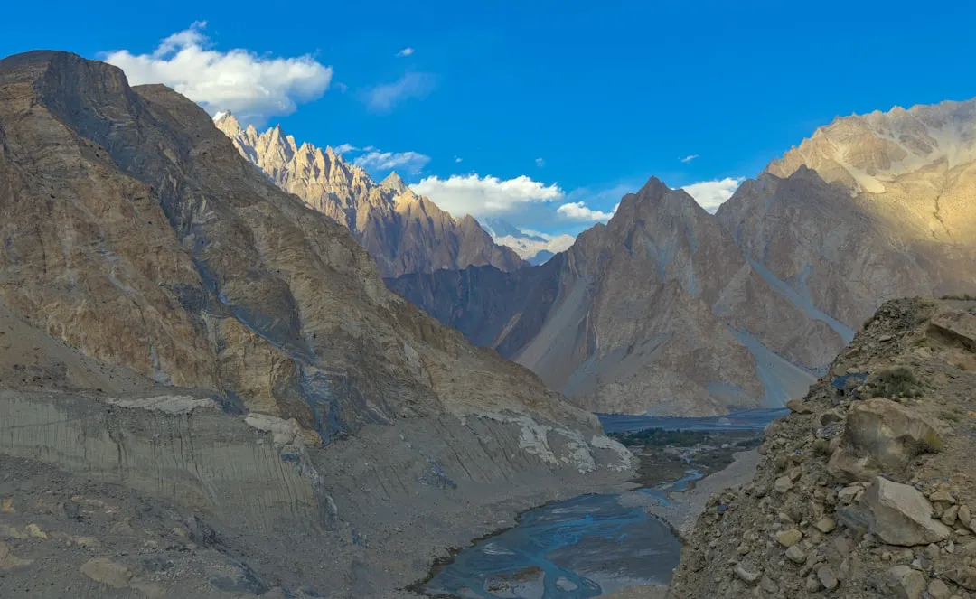
The landscape is a masterclass in geological drama. For hundreds of kilometres, the route is carved directly into the granite faces of the Indus and Hunza River gorges. The sheer scale of the rock walls, often rising 3,000 to 4,000 metres directly from the riverbed, creates an environment of humbling immensity. As the trek progresses north, the arid brown of the lower valleys gives way to the emerald-green orchards of the Hunza Valley, where ancient terraced fields of apricot and apple trees are irrigated by glacial meltwater. Above these orchards tower some of the most iconic peaks in mountaineering history, including Rakaposhi (7,788 m), Nanaga Parbat (8,126 m), and the jagged spires of the Passu Cones.
Walking the KKH is as much a cultural odyssey as it is a physical challenge. The route passes through a mosaic of ethnic and linguistic territories, from the conservative villages of Kohistan to the liberal, highly educated communities of Upper Hunza (Gojal). Walkers will encounter Shina, Burushaski, and Wakhi speakers, each with distinct traditions, architecture, and histories. The hospitality of the local people is legendary; it is common for trekkers to be invited for tea or a meal multiple times a day. However, the trek demands significant mental fortitude. The environment is harsh, with summer temperatures in the lower canyons exceeding 40 degrees Celsius, while the high-altitude sections near the Chinese border can drop well below freezing even in mid-summer. This is a journey for those who seek to understand the intersection of human ingenuity and the raw, untameable power of the high mountains.
History and Cultural Context
The Karakoram Highway follows one of the many branches of the ancient Silk Road, a network of trade routes that for centuries linked the Mediterranean with East Asia. For two millennia, caravans laden with silk, spices, and precious stones navigated these treacherous mountain passes, braving landslides, bandits, and extreme weather. The modern highway, however, is a product of the mid-20th century. Construction began in 1959 as a joint project between the governments of Pakistan and China, intended to create a strategic and commercial link between the two nations. It was an undertaking of unprecedented difficulty, requiring the carving of a road through some of the most unstable and vertical terrain on the planet.
The highway was completed in 1979 and opened to the public in 1986. The human cost of the project was immense; it is often said that "one life was lost for every kilometre of road built," with over 1,000 workers dying during construction due to rockfalls, avalanches, and falls into the precipitous gorges. Today, the KKH stands as a symbol of "Pak-China Friendship," but for the local communities, it represented a fundamental shift in their way of life. Before the road, valleys like Hunza were isolated kingdoms, accessible only by narrow footpaths and dangerous rope bridges. The highway brought trade, tourism, and modern infrastructure, but it also brought the challenges of rapid modernisation and environmental pressure.
Culturally, the region is a fascinating crossroads. In the south, the influence of the Indus Valley and the plains of Punjab is evident. As you move north into Gilgit-Baltistan, the culture becomes increasingly influenced by Central Asian and Tibetan traditions. The Hunza Valley, in particular, has a unique history; it was an independent princely state until 1974, ruled by a "Mir" from the Baltit Fort. The people of Hunza are known for their longevity and their unique language, Burushaski, which is a language isolate—meaning it has no known relationship to any other language in the world. Walking this route allows for a slow-motion observation of these cultural shifts, providing a depth of experience that is impossible to achieve by vehicle.
Want more background? Read extended notes on history and cultural context → Learn more
Seasonal Highlights and Weather Reality
The window for trekking the full length of the Karakoram Highway is dictated by the extreme climate of the high-altitude passes and the intense heat of the lower valleys. The primary season runs from May to October, but each month offers a vastly different experience.
Spring (May to June): This is perhaps the most beautiful time to walk through the Hunza and Nagar valleys. The orchards are in full bloom, with white and pink blossoms contrasting against the snow-capped peaks. However, the lower sections of the trek (near Besham and Chilas) can already be uncomfortably hot, with temperatures reaching 35-40 degrees Celsius. High-altitude sections near Khunjerab may still have significant snow, and some side trails may remain blocked.
Summer (July to August): This is the peak season for the high-altitude sections. The Khunjerab Pass is clear of snow, and the weather in the northern reaches is generally pleasant. However, this is also the monsoon season in Pakistan. While the Karakoram is largely in a rain shadow, the lower sections of the KKH (Kohistan and the Kaghan Valley bypass) can experience heavy rains, leading to frequent landslides and road closures. The heat in the Indus gorge during these months is oppressive and requires careful hydration management.
Autumn (September to October): Many experienced trekkers consider this the best time for the KKH. The monsoon rains have subsided, the air is exceptionally clear, and the autumn colours in the valleys are spectacular, with poplar and apricot trees turning brilliant shades of gold and orange. Temperatures are cooler and more manageable for long-distance walking, though nights at high altitude begin to drop significantly below freezing by mid-October.
Winter (November to April): Trekking the full route in winter is not recommended for anyone other than professional winter expeditionists. The Khunjerab Pass is frequently closed due to heavy snow, and temperatures can drop to -30 degrees Celsius. The risk of avalanches in the narrow gorges is extreme, and many local guesthouses close for the season.
Recommended Itinerary
60-Day Karakoram Highway Expedition Itinerary
Stage 1: The Indus Gorge (Islamabad to Besham)
- Distance: 270 km
- Duration: 10–12 days
- Terrain: Low-altitude hills transitioning into deep river canyons
- Key Waypoints: Abbottabad, Mansehra, Thakot Bridge
- Experience the transition from the humid plains to the rugged foothills of the Himalaya
- Cross the mighty Indus River at Thakot, marking the official start of the mountain highway
- High temperatures and humidity require early morning starts
Stage 2: The Land of Kohistan (Besham to Chilas)
- Distance: 200 km
- Duration: 8–10 days
- Terrain: Extremely narrow, vertical gorges with high rockfall risk
- Key Waypoints: Pattan, Dassu, Komila
- One of the most challenging sections due to the verticality of the terrain and the heat
- Observe the incredible engineering of the road carved into sheer granite cliffs
- Conservative local culture; modest dress and respectful interaction are essential
Stage 3: The Junction of Giants (Chilas to Gilgit)
- Distance: 130 km
- Duration: 5–7 days
- Terrain: Arid high-altitude desert
- Key Waypoints: Raikot Bridge (access to Fairy Meadows), Jaglot, Three Mountain Junction
- Witness the "Three Mountain Junction" where the Himalaya, Karakoram, and Hindu Kush meet
- Spectacular views of Nanga Parbat (8,126 m) from the highway
- Arrive in Gilgit, the administrative and logistical hub of the region, for a well-earned rest
Stage 4: The Heart of Hunza (Gilgit to Karimabad)
- Distance: 100 km
- Duration: 4–5 days
- Terrain: Ascending valley with dramatic peak views
- Key Waypoints: Rakaposhi Viewpoint, Aliabad, Karimabad
- The most scenic section of the trek, with constant views of Rakaposhi (7,788 m)
- Transition into the Ismaili culture of Hunza, known for its hospitality and openness
- Explore the ancient Baltit and Altit Forts in Karimabad
Stage 5: The Upper Karakoram (Karimabad to Passu)
- Distance: 50 km
- Duration: 3–4 days
- Terrain: Glacial valleys and jagged spires
- Key Waypoints: Attabad Lake, Gulmit, Passu Cones
- Walk alongside the turquoise waters of Attabad Lake (formed by a massive landslide in 2010)
- View the iconic Passu Cones (Tupopdan Peak) and the massive Passu Glacier
- Cross the famous Hussaini Suspension Bridge (optional side trip)
Stage 6: The High Plateau (Passu to Khunjerab Pass)
- Distance: 150 km
- Duration: 7–10 days
- Terrain: High-altitude alpine tundra
- Key Waypoints: Sost (last town), Dih, Khunjerab National Park
- Final ascent into the Khunjerab National Park, home to Marco Polo sheep and snow leopards
- Significant altitude gain; pace must be slowed to allow for acclimatisation
- Reach the Khunjerab Pass (4,693 m) and the Chinese border gate
Important Notes:
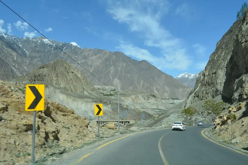
- This is a road-based trek; walkers must be vigilant regarding truck traffic
- Distances are approximate and depend on chosen side trips and detours
- The route is entirely uphill when travelling North; Southbound is an option but less common
- NOC (No Objection Certificate) is required for foreigners in many sections
- Water must be treated; glacial silt is heavy in untreated river water
Planning and Bookings
Book Your Trip
Everything you need to plan your journey
Accommodation
Find places to stay near Gilgit
Flights
Search flights to Gilgit
Essential Preparation
The Karakoram Highway Trek is a logistical undertaking that requires months of preparation. Unlike well-marked trails in Europe or North America, the KKH is a working international highway through a sensitive border region. Foreign trekkers must obtain a Pakistan Tourist Visa in advance, and more importantly, a No Objection Certificate (NOC) for certain restricted areas in Gilgit-Baltistan and Kohistan. These regulations change frequently, so consulting with a local trekking agency in Islamabad or Gilgit is highly recommended.
Physical fitness is paramount. While the road provides a consistent surface, the sheer distance (1,200 km) and the cumulative elevation gain (4,600 m) will test the endurance of even seasoned walkers. Training should focus on long-distance weight-bearing walks and cardiovascular conditioning for high-altitude sections. Additionally, walkers should be prepared for the psychological challenge of walking alongside traffic and navigating the intense heat of the lower Indus gorge.
Trail Accommodation
Accommodation along the KKH varies from basic roadside dhabas to comfortable hotels in major towns. There is no formal "hut system" like those found on the Milford Track or in the Alps.
Types of Accommodation:
- Hotels and Guesthouses: Available in major hubs like Besham, Chilas, Gilgit, Karimabad, and Sost. Prices range from 2,000 to 10,000 PKR per night.
- Roadside Dhabas: Small eateries that often have a "charpoy" (traditional string bed) available for travellers. These are very basic and usually only suitable for solo male travellers or those on a strict budget.
- Camping: Essential for the sections between major towns, particularly in Kohistan and the final stretch to Khunjerab Pass. You must be self-sufficient with a high-quality four-season tent.
- Homestays: Increasingly common in the Hunza Valley, providing a unique opportunity to experience local life.
Facilities: In towns, you will find electricity and occasionally WiFi. In remote sections, expect no power, no running water, and very basic pit toilets. Always carry a power bank and a reliable water filtration system.
Required Gear
- Trekking Boots: High-quality, well-broken-in boots with excellent ankle support. The road surface is hard and unforgiving on the feet.
- Four-Season Tent: Must be able to withstand high winds and potential snow in the northern sections.
- Sleeping Bag: Rated to at least -10°C for the high-altitude nights near Khunjerab.
- Backpack: 65-75L capacity with a high-quality suspension system to manage the weight of food and water.
- Clothing Layers: Moisture-wicking base layers, an insulating mid-layer (fleece or down), and a breathable waterproof outer shell.
- Sun Protection: High-SPF sunscreen, polarised sunglasses, and a wide-brimmed hat. The UV radiation at 4,000 metres is intense.
- Navigation: GPS device with offline maps (GAIA or AllTrails) and physical paper maps of the region.
What to Bring
- Water Treatment: A high-capacity filter (like a Katadyn or Sawyer) plus purification tablets. Glacial water is full of fine silt that can clog filters quickly.
- Food Supplies: While dhabas provide basic meals (dal, rice, roti), you should carry high-energy snacks, electrolytes, and emergency dehydrated meals for remote stretches.
- First Aid Kit: Comprehensive kit including blister care, broad-spectrum antibiotics, rehydration salts, and Diamox (for altitude sickness).
- Power Solutions: Solar charger or large-capacity power banks (20,000mAh+) as electricity is unreliable.
- Personal Hygiene: Biodegradable soap, wet wipes, and hand sanitiser. Toilet paper is rarely provided in local facilities.
- Cash: Sufficient Pakistani Rupees (PKR) for the entire journey. ATMs are only available in Gilgit and Aliabad, and they frequently fail to accept international cards.
Permits
Navigating the permit requirements for the Karakoram Highway is one of the most complex aspects of the trek. Because the highway passes through sensitive border regions and areas with varying security profiles, regulations are strictly enforced by local police and the military.
Visa and NOC Requirements:
- Tourist Visa: All foreign nationals must have a valid Pakistan Tourist Visa. It is recommended to apply for the "Trekking Visa" category if you plan on doing side trips to base camps.
- No Objection Certificate (NOC): This is the most critical document. An NOC is required for foreigners to travel through certain parts of Kohistan and to stay overnight in restricted zones. Obtaining an NOC independently is nearly impossible; most trekkers hire a registered Pakistani trekking agency to facilitate this process.
- Registration: You must register at every police checkpost (and there are many) along the KKH. This involves providing copies of your passport, visa, and NOC. Carry at least 50 photocopies of these documents to hand over at checkposts.
National Park Fees:
- Khunjerab National Park: An entry fee (approximately 10-20 USD for foreigners) is required to enter the park boundaries near the Chinese border.
- Central Karakoram National Park (CKNP): If you take side trips toward K2 or other major peaks, additional trekking permits and fees apply.
Security Escorts: In certain sections of Kohistan, local police may insist on providing a free armed escort for foreign walkers. This is a standard safety protocol and should be accepted graciously, though it can change the "wilderness" feel of the trek.
Other Activities in the Area
The region surrounding the Karakoram Highway offers some of the most spectacular adventure opportunities in the world. Consider these additions to your journey:
- Fairy Meadows and Nanga Parbat Base Camp: A world-famous side trip from Raikot Bridge. A jeep ride and a short trek lead to a lush alpine meadow with an unparalleled view of the 8,126-metre "Killer Mountain."
- Attabad Lake Boating: Take a boat across the 21-kilometre-long turquoise lake, which was formed in 2010. The contrast of the blue water against the barren mountains is stunning.
- Baltit and Altit Forts: Visit these restored 700-year-old forts in Karimabad to learn about the history of the Mirs of Hunza and the architectural heritage of the region.
- Rock Climbing in Passu: The granite spires around Passu offer world-class climbing opportunities for those with the necessary skills and equipment.
- Naltar Valley: A scenic valley near Gilgit famous for its colourful lakes and winter skiing facilities.
- Shopping in Gilgit Bazaar: Explore the bustling markets for local handicrafts, pashmina shawls, and precious gemstones (rubies and emeralds) mined in the surrounding mountains.
Safety and Conditions
Road Safety: The single greatest danger on the KKH Trek is not the mountains, but the traffic. The highway is a major artery for heavy trucks (often beautifully decorated "jingle trucks") and high-speed buses. There are no pavements or hard shoulders in many sections. Walkers must wear high-visibility clothing, walk facing the traffic, and be extremely cautious on blind corners and in tunnels.
Altitude Sickness (AMS): The trek involves a significant ascent from near sea level to over 4,600 metres. Acute Mountain Sickness is a genuine risk, particularly in the final stages from Sost to Khunjerab. It is essential to follow a conservative acclimatisation schedule, stay hydrated, and descend immediately if symptoms (severe headache, nausea, dizziness) persist.
Natural Hazards: The Karakoram is one of the most geologically active regions on Earth. Landslides and rockfalls are common, especially during the monsoon (July-August) or after heavy rain. Always check local weather and road conditions before starting a day's walk. In the narrow gorges of Kohistan, be aware of the "shooting gallery" effect where rocks can fall from high above without warning.
Health and Hygiene: Waterborne illnesses are common. Never drink untreated water from streams or taps. Food hygiene at roadside dhabas can be variable; stick to freshly cooked, hot food and avoid raw salads or unpeeled fruit. Ensure your vaccinations (Hepatitis A, Typhoid, Polio) are up to date.
Political and Social Sensitivity: While Gilgit-Baltistan is generally very safe for tourists, the political situation in Pakistan can be fluid. Always check your government's travel advice before departure. Respect local customs: dress modestly (shoulders and knees covered for both men and women), ask permission before taking photos of people, and avoid discussing sensitive political or religious topics.
Side Trips and Points of Interest
The Three Mountain Junction: Located near the village of Jaglot, this is the only place on Earth where three major mountain ranges meet. To the north is the Karakoram, to the south-east the Himalaya, and to the west the Hindu Kush. It is also the confluence of the Indus and Gilgit Rivers. A small monument marks the spot, providing a perfect location for reflection on the scale of the journey.
Rakaposhi Viewpoint: Located right on the KKH near Ghulmet, this spot offers one of the most accessible views of a 7,000-metre peak in the world. Rakaposhi rises over 5,000 metres directly from the valley floor to its summit (7,788 m), creating a wall of ice and snow that dominates the horizon. There are several small cafés here where you can enjoy tea while staring at the massive Minapin Glacier.
The Passu Suspension Bridge: For those with a head for heights, the Hussaini and Passu suspension bridges are iconic landmarks. These long, swaying structures made of wooden planks and wire cables cross the wide, grey Hunza River. They are still used by locals to move livestock and supplies, though they are increasingly popular with adventurous tourists.
The Sacred Rocks of Hunza: Located near Haldeikish, these are ancient petroglyphs carved into the rocks alongside the highway. They date back to the Kushan era and depict ibex, hunters, and Buddhist symbols, serving as a silent testament to the thousands of years of human travel along this route.
Khunjerab National Park: The final 50 kilometres of the trek pass through this high-altitude sanctuary. It is one of the best places in Pakistan to spot rare wildlife, including the Marco Polo sheep, Himalayan ibex, and the elusive snow leopard. The landscape here shifts to a high-altitude plateau, reminiscent of the Tibetan Steppe.
Leave No Trace
The Karakoram Highway passes through some of the most fragile high-altitude ecosystems in the world. With the increase in tourism and the development of the highway, environmental pressure has reached a critical point. As a long-distance walker, your impact is spread over a vast area, making it even more important to adhere to strict Leave No Trace principles.
Environmental Stewardship:
- Waste Management: There is no formal waste collection in most of the northern areas. Pack out all your trash, including micro-plastics and cigarette butts. Avoid buying single-use plastic water bottles; use a high-quality filter and a reusable bottle instead.
- Human Waste: In remote areas where no toilets are available, bury human waste in a "cathole" at least 15 centimetres deep and at least 60 metres away from any water source. Pack out all used toilet paper in a sealed bag.
- Respect Wildlife: In Khunjerab National Park, keep a respectful distance from all animals. Do not feed wildlife, as this disrupts their natural foraging behaviour and can make them dependent on humans.
- Protect Water Sources: Do not use soap or detergents directly in streams or rivers. Even biodegradable soap can harm aquatic life. Carry water 60 metres away from the source for washing.
- Stay on the Road/Path: While it is a road trek, when taking side trips or camping, stay on established trails to avoid trampling fragile alpine vegetation that can take decades to recover.
By walking the KKH with respect and humility, you help ensure that this incredible corridor remains a viable destination for future generations of adventurers and a healthy home for the local communities.