Karakoram Highway - The Eighth Wonder of the World
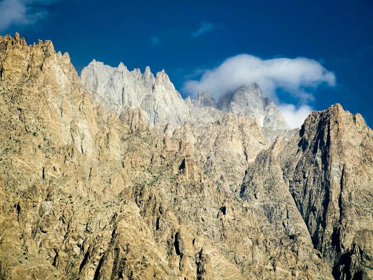
The Karakoram Highway (KKH) is not merely a road; it is a monumental feat of engineering and a 1,300-kilometre journey through the most concentrated collection of high peaks on Earth. Stretching from Hassan Abdal in Pakistan to Kashgar in China, this legendary route traverses the ancient Silk Road's footsteps, carving a path through the collision zone of the Indian and Eurasian tectonic plates. For trekkers, cyclists, and overlanders, the KKH represents the ultimate high-altitude odyssey, offering access to the Karakoram, Himalaya, and Hindu Kush mountain ranges. This is a landscape of extremes, where the Indus River roars through deep, arid canyons and granite spires like Rakaposhi and Nanga Parbat pierce the sky at over 7,000 and 8,000 metres respectively. To travel the KKH is to witness the raw power of geological forces and the enduring resilience of the mountain cultures that call these vertical worlds home.
- Distance: 1,300 km (total length); approximately 800 km within Pakistan
- Duration: 15–20 days (recommended for a comprehensive trekking and exploration journey)
- Season: May to September (Khunjerab Pass is typically closed by snow from November to April)
- Highest Point: Khunjerab Pass (4,693 m)
- Difficulty: Challenging (due to altitude, remote conditions, and unpredictable weather)
- Closest City: Gilgit (central hub) or Islamabad (international gateway)
- Direction: South to North (Islamabad to Khunjerab Pass) is the standard progression for acclimatisation
Overview
Often referred to as the "Eighth Wonder of the World," the Karakoram Highway is the highest paved international road on the planet. It serves as the primary artery connecting Pakistan with China, but for the intrepid traveller, it is a gateway to some of the most spectacular and remote wilderness areas in Asia. The journey begins in the humid plains of Punjab and the foothills of the Khyber Pakhtunkhwa province, before entering the rugged, rain-shadowed gorges of the Indus River. As the road winds north, the landscape transforms from subtropical greenery to a high-altitude desert of staggering proportions. The sheer scale of the mountains here is difficult to comprehend; the KKH passes within sight of several peaks over 7,000 metres, and the views of Nanga Parbat (8,126 m) from the roadside are among the most humbling sights in the world of mountaineering.
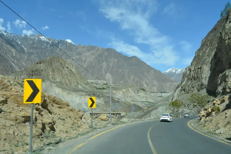
The route is defined by its dramatic geography. It follows the Indus River for hundreds of kilometres, passing through the "Three Mountain Junction" near Jaglot, where the Himalaya, Karakoram, and Hindu Kush ranges meet. This is the only place on Earth where three of the world's highest mountain systems converge. Beyond Gilgit, the highway enters the Hunza Valley, a region legendary for its longevity, terraced apricot orchards, and the soaring peaks of the Rakaposhi-Haramosh Range. The final stretch in Pakistan climbs through the Gojal region, passing the turquoise waters of Attabad Lake and the iconic Passu Cones, before reaching the desolate, windswept plateau of the Khunjerab Pass at nearly 4,700 metres.
Travelling the KKH is as much a cultural experience as it is a physical one. The route passes through diverse linguistic and ethnic territories, from the Shina-speaking regions of Kohistan and Gilgit to the Burushaski and Wakhi heartlands of Hunza and Gojal. The hospitality of the local people is world-renowned, providing a warm contrast to the harsh, vertical landscape. However, the KKH is also a place of constant change; landslides, glacial surges, and seasonal floods are a reality of life here, making every journey a unique and unpredictable adventure. Whether you are trekking to base camps, cycling the steep gradients, or exploring the ancient forts of the Silk Road, the Karakoram Highway demands patience, respect, and a spirit of discovery.
History and Cultural Context
The history of the Karakoram Highway is a saga of human ambition and sacrifice. For millennia, various branches of the Silk Road wound through these valleys, carrying pilgrims, traders, and armies between the Indian subcontinent and Central Asia. Famous travellers like Xuanzang and Marco Polo navigated these treacherous passes, which were then nothing more than narrow footpaths clinging to cliff faces. The modern highway was conceived in the 1960s as a joint project between Pakistan and China, aimed at creating a strategic and commercial link through the mountains. Construction began in 1966 and was completed in 1978, though it was not opened to the public until 1986.
The human cost of building the road was immense. It is estimated that over 810 Pakistani and 200 Chinese workers lost their lives during construction, primarily due to landslides, falls, and premature explosions while blasting through the granite walls of the Karakoram. The saying "one life for every kilometre" is often cited by locals to describe the sacrifice required to tame this landscape. The engineering challenges were unprecedented, requiring the construction of hundreds of bridges and the carving of a stable roadbed into some of the most unstable geological terrain on Earth. Today, the highway is a symbol of the "all-weather friendship" between Pakistan and China, and it continues to be upgraded as part of the China-Pakistan Economic Corridor (CPEC).
Culturally, the KKH acts as a bridge between the Islamic traditions of the south and the Central Asian influences of the north. In the Hunza Valley, the Ismaili community—a progressive branch of Shia Islam—has fostered a culture of high literacy and social development, making it one of the most welcoming regions for international visitors. The ancient forts of Baltit and Altit stand as sentinels of a time when local Mirs (kings) controlled the trade routes, levying taxes on caravans passing through their mountain strongholds. The petroglyphs found at various sites along the highway, such as those at Shatial and Chilas, date back thousands of years, depicting Buddhist stupas, ibex, and ancient inscriptions that testify to the road's enduring importance as a corridor of human movement.
Want more background? Read extended notes on history and cultural context → Learn more
Seasonal Highlights and Weather Reality
The Karakoram Highway is a seasonal route, with the high-altitude sections dictated by snow and ice. The best time to travel is from May to September, when the weather is most stable and the passes are clear. However, each month within this window offers a different experience.
Spring (May to June): This is perhaps the most beautiful time in the valleys. The apricot and cherry blossoms of Hunza and Gilgit are in full bloom, creating a sea of pink and white against the backdrop of snow-capped peaks. The weather is crisp and clear, though the higher passes like Khunjerab may still experience sub-zero temperatures and occasional snow showers. This is an excellent time for photography and lower-altitude trekking.
Summer (July to August): This is the peak season for mountaineering and high-altitude trekking. The weather is warm in the valleys (sometimes reaching 35°C in Gilgit), and the snow has receded from the higher trails. However, this is also the monsoon season in the southern sections of the KKH (near Besham and Kohistan). While the Karakoram is largely in a rain shadow, the southern approach can be prone to heavy rain and landslides, which can block the road for days. Glacial melt is at its peak, making river crossings more challenging and turning the Indus into a raging torrent.
Autumn (September to October): As the heat of summer fades, the valleys turn into a riot of gold and orange as the poplar and fruit trees change colour. The air is exceptionally clear, providing the best views of the high peaks. By late October, the first winter snows begin to fall on the passes, and the Khunjerab border typically closes by the end of November. This is a quiet, contemplative time to visit, with fewer tourists and cool, pleasant daytime temperatures.
Winter (November to April): The KKH becomes a formidable environment in winter. The Khunjerab Pass is closed, and many of the higher valleys are cut off by snow. While the road to Gilgit and Karimabad usually remains open, travel is slow and hazardous due to ice and the constant threat of avalanches. Most guesthouses close, and the extreme cold (dropping to -20°C in Hunza) makes it unsuitable for most travellers unless they are specifically equipped for winter mountaineering.
Recommended Itinerary
20-Day Karakoram Highway Expedition
Day 1–2: Islamabad to Besham
- Distance: 270 km
- Elevation gain: 600 m
- Time: 7–9 hours driving
- Depart Islamabad and head north through the lush Hazara region
- Pass through Abbottabad and Mansehra
- Enter the Indus River gorge at Thakot, where the KKH officially begins its mountain ascent
- Overnight in Besham, a bustling riverside town
- Acclimatise to the increasing humidity and heat of the lower Indus
Day 3–4: Besham to Chilas and Raikot Bridge
- Distance: 200 km
- Elevation gain: 650 m
- Time: 6–8 hours driving
- The road becomes more rugged as it enters the Kohistan region
- View the ancient petroglyphs at Shatial
- Arrive at Raikot Bridge, the gateway to Nanga Parbat
- Transfer to 4WD jeeps for the hair-raising drive to Tato, followed by a 3-hour trek to Fairy Meadows
- Spend Day 4 exploring Fairy Meadows (3,300 m) with stunning views of the Raikot Face of Nanga Parbat
Day 5–7: Fairy Meadows to Gilgit and Naltar Valley
- Distance: 100 km (road) + trekking
- Elevation: Descent to 1,200 m, then climb to 1,500 m
- Time: 3 hours driving from Raikot
- Stop at the "Three Mountain Junction" near Jaglot to see the meeting of the ranges
- Arrive in Gilgit, the administrative capital of the north
- Explore the Gilgit Bazaar and the Kargah Buddha (7th-century rock carving)
- Day 7: Side trip to Naltar Valley, famous for its colourful lakes and alpine scenery
Day 8–11: Gilgit to Karimabad (Hunza Valley)
- Distance: 100 km
- Elevation gain: 900 m
- Time: 3 hours driving
- Stop at the Rakaposhi Viewpoint in Ghulmet for a close-up of the 7,788 m peak
- Arrive in Karimabad, the heart of the Hunza Valley
- Visit Baltit Fort (700 years old) and Altit Fort (900 years old)
- Day 10: Trek to Rakaposhi Base Camp or explore the Hopar Glacier in the Nagar Valley
- Day 11: Relax in Karimabad, enjoy local walnut cake, and soak in the views of Ultar Sar and Ladyfinger Peak
Day 12–15: Karimabad to Passu and Upper Hunza (Gojal)
- Distance: 50 km
- Elevation gain: 300 m
- Time: 2 hours driving
- Cross the Attabad Lake by boat or via the newly constructed tunnels
- Arrive in Passu, home to the iconic Passu Cones (Tupopdan) and the Passu Glacier
- Day 13: Walk across the famous Hussaini Suspension Bridge (not for the faint-hearted)
- Day 14: Trek to Borith Lake and the white Passu Glacier
- Day 15: Explore the remote village of Shimshal or the Misgar Valley (requires additional permits)
Day 16–18: Passu to Sost and Khunjerab Pass
- Distance: 120 km (return)
- Elevation gain: 2,200 m
- Time: 4–5 hours driving return
- Drive to Sost, the final Pakistani border town and customs post
- Continue the steep climb through the Khunjerab National Park
- Reach the Khunjerab Pass (4,693 m), the highest point of the KKH and the border with China
- Look for Himalayan Ibex and Golden Marmots along the roadside
- Return to Sost or Passu for the night
Day 19–20: Return Journey to Gilgit and Islamabad
- Distance: 600 km
- Time: 12–15 hours driving (often split over two days)
- Reflect on the journey while descending the Indus gorge
- Optional flight from Gilgit to Islamabad (weather permitting) for a spectacular aerial view of the Karakoram
- Final dinner in Islamabad to celebrate the completion of the Eighth Wonder
Important Notes:
- Road conditions can change instantly due to landslides; always carry extra food and water
- The Khunjerab Pass is a high-altitude environment; monitor for symptoms of AMS (Acute Mountain Sickness)
- Respect local customs, especially in more conservative areas like Kohistan and Chilas
- Ensure your visa and any necessary No Objection Certificates (NOCs) are in order before departure
- Public transport (NATCO buses) is available, but hiring a private 4WD is recommended for flexibility
Planning and Bookings
Book Your Trip
Everything you need to plan your journey
Accommodation
Find places to stay near Gilgit
Flights
Search flights to Gilgit
Essential Preparation
Planning a journey along the Karakoram Highway requires more logistical foresight than a standard trek. The primary considerations are transport, permits, and health. Most travellers begin their journey in Islamabad, where they can arrange for a private vehicle, driver, and guide. While it is possible to use public buses (NATCO), a private 4WD offers the flexibility to stop at viewpoints and navigate the rough side roads leading to trailheads like Fairy Meadows or Naltar.
Fitness is crucial, not just for the trekking components but for the physical toll of long days on mountain roads. Altitude acclimatisation should be built into your itinerary; jumping from Islamabad (500 m) to Khunjerab (4,693 m) too quickly is a recipe for altitude sickness. Gilgit and Karimabad serve as excellent bases for acclimatisation. Additionally, ensure you have a reliable way to communicate; while major towns have mobile signals (SCOM is the most reliable provider in the north), remote valleys do not. Satellite phones or GPS messengers are recommended for those heading deep into the mountains.
Trail Accommodation
Accommodation along the KKH ranges from basic roadside "truck stop" hotels to high-end boutique resorts in Hunza. In remote trekking areas, camping is the only option.
Accommodation Types:
- Hotels and Guesthouses: Available in Besham, Chilas, Gilgit, Karimabad, and Passu. In Hunza, you can find comfortable rooms with hot water and stunning views. In Chilas and Besham, facilities are more functional and basic.
- PTDC Motels: The Pakistan Tourism Development Corporation operates motels at key locations. They are generally reliable but can be dated.
- Camping: Essential for Fairy Meadows, Nanga Parbat Base Camp, and any multi-day treks off the main highway. Many guesthouses in Hunza allow camping on their grounds for a small fee.
- Homestays: Increasingly popular in the Gojal region (Upper Hunza), offering a chance to experience local Wakhi culture and food.
Facilities Provided:
- In major towns: Electricity (subject to load shedding), Wi-Fi (often slow), and sit-down toilets.
- In remote areas: Pit toilets, no electricity, and bucket showers.
- Food: Most guesthouses provide meals, typically dal, rice, chicken curries, and local breads (nan and chapati).
What's NOT Provided:
- Consistent high-speed internet.
- Heating in budget accommodation (essential to bring a warm sleeping bag even for indoor stays in shoulder seasons).
- Reliable ATM access (carry sufficient cash in Pakistani Rupees from Islamabad or Gilgit).
Required Gear
- Footwear: Sturdy, waterproof trekking boots for side trips; comfortable walking shoes or sandals for travel days.
- Clothing: Layering is key. Lightweight, breathable clothes for the hot lower valleys; fleece and down layers for the high-altitude sections. Modest dress is required (long trousers and shirts that cover shoulders).
- Outerwear: A high-quality waterproof and windproof jacket. The wind at Khunjerab Pass and on glaciers can be biting.
- Sleeping Bag: A 4-season bag (rated to -10°C) if camping or staying in basic guesthouses during shoulder seasons.
- Backpack: A 50–70L main pack for gear and a 20L daypack for daily essentials.
- Navigation: Offline maps (Maps.me or Gaia GPS) and a physical map of the Northern Areas.
- Sun Protection: High-SPF sunscreen, lip balm with SPF, and category 3 or 4 sunglasses to prevent snow blindness on glaciers.
What to Bring
- Water Treatment: A portable filter (like a Sawyer Squeeze) or purification tablets. Tap water is not safe, and plastic bottle waste is a major issue.
- First Aid Kit: Include Diamox (for altitude), rehydration salts, broad-spectrum antibiotics, and blister care.
- Power Bank: High-capacity (20,000mAh+) to keep devices charged during frequent power outages.
- Cash: Pakistani Rupees (PKR) in small denominations. Credit cards are rarely accepted outside of high-end hotels in Islamabad or Gilgit.
- Toiletries: Biodegradable soap, wet wipes, and hand sanitiser. Toilet paper is not always provided in public facilities.
- Snacks: Energy bars, nuts, and dried fruit. While local food is excellent, having familiar high-energy snacks is vital for long trekking days.
- Headlamp: Essential for navigating guesthouses during power cuts and for early morning starts.
Permits
Navigating the permit requirements for the Karakoram Highway and its surrounding valleys is a critical part of your preparation. Requirements can change based on the current security situation and your nationality.
Visa Requirements:
- Most nationalities require a visa to enter Pakistan. The E-Visa system is now the standard and generally efficient.
- When applying, specify that you intend to visit Gilgit-Baltistan. You may be asked for a "Letter of Invitation" (LOI) from a registered Pakistani tour operator.
- Ensure your visa is valid for the entire duration of your stay, as extensions in the north can be bureaucratic and time-consuming.
No Objection Certificates (NOCs):
- While the main Karakoram Highway is generally open to foreigners without a special permit, certain side valleys and areas near international borders (like the Line of Control or the Afghan border) require an NOC.
- As of recent regulations, many parts of Gilgit-Baltistan are "open," but it is essential to check the latest list of restricted zones. Areas like the Shimshal Valley or treks near the Baltoro Glacier always require specific permits and often a licensed guide.
- If you are travelling with a tour operator, they will handle the NOC process for you. If travelling independently, you may need to visit the Home Department in Gilgit to clarify your itinerary.
Registration:
- You will encounter numerous police and military checkpoints along the KKH (especially in Kohistan and near Gilgit).
- Pro Tip: Carry at least 20–30 photocopies of your passport and visa. At each checkpoint, the officials will need a copy (often called a "form") to register your movement. This saves significant time and prevents you from having to hand over your original passport repeatedly.
Khunjerab Pass and China Border:
- If you intend to cross into China, you must have a valid Chinese visa obtained in your home country (it is extremely difficult to get one in Pakistan).
- The border is closed on weekends and public holidays. Ensure your transport is coordinated with the border opening times.
- There is a fee for entering the Khunjerab National Park (approximately US$10–20 for foreigners), payable at the entry gate near Sost.
Other Activities in the Area
The KKH is a corridor to a vast array of adventures. If you have extra time, consider these world-class experiences:
- Trekking to K2 Base Camp: Starting from Skardu (a side trip from the KKH), this is one of the world's great treks, leading to the base of the world's second-highest peak.
- Attabad Lake Boating: Formed by a massive landslide in 2010, this 21-km long turquoise lake is stunning. You can take a boat ride or enjoy jet skiing against the backdrop of jagged peaks.
- Rock Climbing in the Nangma Valley: Known as the "Yosemite of the Karakoram," this area offers incredible granite spires for experienced climbers.
- Visiting the Deosai Plains: The second-highest plateau in the world, located between Gilgit and Skardu. It is a rolling landscape of wildflowers and home to the Himalayan Brown Bear.
- Shopping in Gilgit and Karimabad: Look for high-quality pashmina shawls, local gemstones (rubies and emeralds), and traditional Hunza embroidery.
- Cultural Festivals: If your timing is right, witness a game of "freestyle polo" in Gilgit or Chitral—a fast, furious, and traditional version of the sport played without modern rules.
Safety and Conditions
Road Hazards: The KKH is one of the most spectacular roads in the world, but also one of the most dangerous. Landslides are common, especially during the monsoon (July–August) and spring melt. Always check the road status with local drivers or the Frontier Works Organisation (FWO). Avoid travelling at night, as the risk of falling rocks and unlit vehicles is high.
Altitude Sickness: The climb from the Indus Valley to the Khunjerab Pass is significant. Acute Mountain Sickness (AMS) can affect anyone regardless of fitness. Symptoms include headache, nausea, and dizziness. The best prevention is a gradual ascent and staying hydrated. If symptoms persist, the only cure is to descend immediately.
Health and Hygiene: "Delhi Belly" (or its local equivalent) is a common ailment. Stick to cooked food, peel your own fruit, and never drink untreated water. In the north, the water often contains high levels of glacial silt, which can be hard on the stomach even if purified; use a filter that can handle fine sediment.
Political and Social Sensitivity: While Gilgit-Baltistan is generally very safe for tourists, the southern sections of the KKH (Kohistan) are more conservative. Dress modestly, avoid discussing sensitive political or religious topics, and always ask for permission before taking photos of people, especially women. Check your government's travel advisory before departure, as the security situation in Pakistan can be fluid.
Emergency Services: There is no formal mountain rescue service in Pakistan like those in the Alps. In an emergency, the Pakistan Army often conducts helicopter evacuations, but these are extremely expensive (US$15,000+) and require a cash deposit or a guaranteed insurance policy. Ensure your travel insurance specifically covers high-altitude trekking and helicopter evacuation.
Side Trips and Points of Interest
Fairy Meadows and Nanga Parbat: A legendary side trip. From Raikot Bridge, a jeep track leads to the start of a trek that opens up to a lush alpine meadow directly beneath the 8,126 m Nanga Parbat. Watching the sunset turn the "Killer Mountain" into a glowing ember is a spiritual experience for many travellers.
The Passu Cones: Also known as Tupopdan, these jagged granite peaks rise sharply above the village of Passu. They are perhaps the most photographed mountains along the KKH. The nearby Passu and Batur glaciers offer accessible day hikes for those wanting to experience the "frozen sea" of the Karakoram.
Hussaini Suspension Bridge: Often cited as one of the most dangerous bridges in the world, this rope and plank structure crosses the Hunza River. While a newer bridge exists, the old one remains a popular (and terrifying) challenge for visitors. It offers a visceral sense of how local people have navigated these rivers for centuries.
Baltit Fort: Perched above Karimabad, this Tibetan-style fort was the seat of the Mirs of Hunza. Restored by the Aga Khan Trust for Culture, it is now a museum that provides deep insight into the history, architecture, and daily life of the Hunza Valley. The views from the roof across the valley to Rakaposhi are unparalleled.
The Three Mountain Junction: Located near the village of Jaglot, this is a unique geographical point where the Indus and Gilgit rivers meet, and the three greatest mountain ranges on Earth—the Himalaya, the Karakoram, and the Hindu Kush—converge. A small monument marks the spot, offering a rare perspective on the planet's tectonic history.
Leave No Trace
The Karakoram is a fragile high-altitude desert ecosystem. With the increase in tourism along the KKH, the pressure on local resources and waste management systems has reached a critical point. As a visitor, you have a responsibility to minimise your impact on this pristine environment.
Your responsibility as a traveller:
- Waste Management: Pack out all non-biodegradable waste. There are no formal recycling facilities in the mountains. Avoid single-use plastics; use a water filter and reusable bottle.
- Respect Water Sources: Do not use soap or detergents directly in streams or lakes. Wash at least 30 metres away from water sources using biodegradable products.
- Stay on Trails: In alpine meadows like Fairy Meadows, stay on established paths to prevent soil erosion and damage to delicate flora.
- Cultural Respect: Respect the privacy of local communities. Do not enter private orchards or homes without an invitation. Always ask before taking photographs.
- Wildlife: Do not disturb or feed wildlife. The Khunjerab National Park is home to endangered species like the Snow Leopard and Marco Polo Sheep; keep a respectful distance.
- Fire: Avoid making open fires, especially in areas where wood is scarce. Use a gas or multi-fuel stove for cooking.
The people of the Karakoram have lived in harmony with these mountains for generations. By following Leave No Trace principles, you help ensure that the "Eighth Wonder" remains a wonder for those who follow.