Kananaskis Highline Trail
The Kananaskis Highline Trail is a spectacular multi-day trek in the heart of Alberta's Canadian Rockies, offering a challenging yet immensely rewarding journey through alpine meadows, over high passes, and past turquoise lakes. This trail is renowned for its breathtaking panoramic views of jagged peaks, expansive glaciers, and the rugged wilderness that defines the Kananaskis Country. It's a true mountain track, demanding a good level of fitness and preparedness, but the vistas and sense of accomplishment are unparalleled. The trail is best suited for experienced hikers looking for an immersive wilderness experience, far from the crowds of more accessible routes.
- Distance: 45.0 km one-way
- Elevation Gain: 1500 m
- Duration: 2-3 days
- Difficulty: Challenging
- Best Time: May-October
- Closest City: Kananaskis
- Trailhead Access: Nearest airport: Calgary (YYC). Drive ~1.5 hours south on Hwy 1, then south on Hwy 40 (Kananaskis Trail). Hwy 40 closes Dec 1-Jun 15 annually. Limited parking at Highwood Pass. No bus/taxi. Kananaskis Conservation Pass required. Trailhead GPS: 50.604418, -115.163561
- Coordinates: 50.8804, -115.1401
Overview
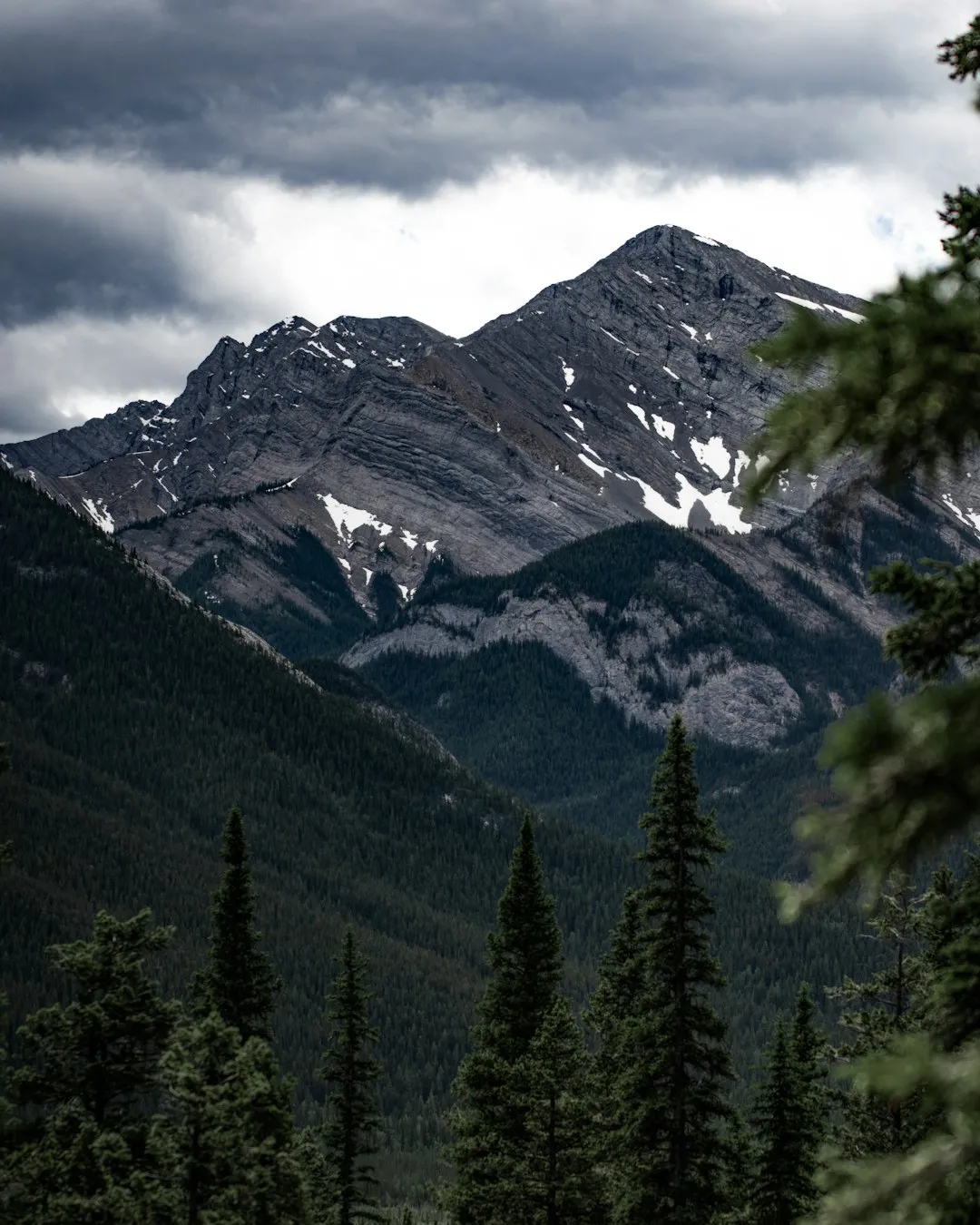
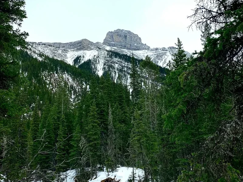
The Kananaskis Highline Trail is a quintessential Canadian Rockies experience, a high-alpine traverse that showcases the raw beauty and grandeur of the landscape. Unlike many valley-bottom trails, the Highline stays at or near the treeline for significant portions, offering continuous, sweeping vistas. The journey begins with a steady ascent, gradually revealing the scale of the surrounding peaks. As you progress, the trail winds through vast alpine meadows carpeted with wildflowers in the summer months, offering a stark contrast to the imposing rock faces and glaciers that dominate the skyline. The route is punctuated by several high passes, each providing a new, awe-inspiring perspective of the Kananaskis Range.
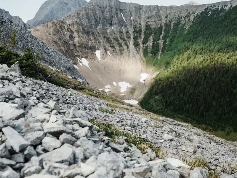
The trail's challenging nature stems from its significant elevation gains and descents, often over rugged terrain. Hikers will encounter scree slopes, rocky sections, and potentially snow patches even in mid-summer, especially on the higher passes. The remoteness of the trail means that self-sufficiency is paramount. While the trail is well-marked, the wilderness is vast, and weather can change with alarming speed in the mountains. The reward for this effort is an intimate connection with a wild and untamed landscape, where wildlife sightings—such as bighorn sheep, mountain goats, and even bears—are not uncommon. The sense of solitude and immersion in nature is profound, making it a truly memorable trek for those who undertake it.
The Highline Trail is a testament to the wild spirit of Kananaskis Country. It’s a place where the sheer scale of the mountains humbles you, the vibrant alpine flora delights you, and the crisp mountain air invigorates you. This is not a walk in the park; it's an expedition into the heart of the Rockies, designed for those who seek adventure and are prepared to earn their views.
History and Cultural Context
The Kananaskis Highline Trail, like much of the Canadian Rockies, has a rich history intertwined with Indigenous peoples, early explorers, and the development of resource industries and tourism. For millennia, the Stoney Nakoda First Nations and other Indigenous groups utilized these lands for hunting, gathering, and seasonal migration. The passes and valleys served as vital routes, and the mountains held deep spiritual significance. Evidence of their presence can be found in ancient tipi rings and traditional land use sites, though much of this history is preserved through oral traditions and archaeological research.
European exploration of the Kananaskis region began in earnest in the late 19th and early 20th centuries. Surveyors, geologists, and adventurers were drawn to the rugged beauty and potential resources of the area. The development of trails, including those that form the basis of the Highline Trail, was often driven by the need to access mineral deposits, establish forestry operations, or simply to explore and map the vast wilderness. Early trails were often rough, following game trails or the paths of least resistance, and were maintained by park wardens and dedicated volunteers.
The establishment of Kananaskis Country as a provincial park in the 1970s marked a significant shift towards conservation and recreational use. The Highline Trail, as it is known today, evolved from a network of older routes, with improvements and connections made over time to create a more defined and accessible, albeit still challenging, hiking experience. The trail’s name itself, "Highline," reflects its characteristic route along the high ridges and alpine zones, a testament to the vision of those who sought to connect these elevated landscapes. The ongoing management of the trail by Alberta Parks aims to balance recreational access with the preservation of the fragile alpine environment and its ecological and cultural heritage.
Seasonal Highlights and Weather Reality
The Kananaskis Highline Trail is a summer and early autumn trek. The primary hiking season typically runs from late May or early June through to October, with the peak season for wildflowers and stable weather occurring from July to September.
Late Spring (May-June): While the lower elevations may be clear of snow, the Highline Trail and its passes are often still snow-covered. Avalanche risk can persist in early spring. This period is generally not recommended for the Highline Trail unless you possess advanced snow travel and navigation skills. Hwy 40 typically opens by June 15th, providing access to Highwood Pass.
Summer (July-August): This is the prime season. Alpine meadows burst into vibrant colour with a spectacular display of wildflowers, including Indian paintbrush, lupine, columbine, and glacier lilies. Wildlife is active, and the days are long, offering ample time for hiking. However, summer also brings the possibility of afternoon thunderstorms, which can develop rapidly and pose a significant hazard in exposed alpine terrain. Temperatures can range from cool mornings and evenings to warm afternoons, but it's essential to be prepared for all conditions.
Early Autumn (September-October): The landscape transforms with the changing colours of the subalpine larch trees, which turn a brilliant gold. The crowds thin out, and the air is crisp and clear. However, snow can begin to fall at higher elevations, and daytime temperatures drop. By mid-October, the trail can become impassable due to snow, and Hwy 40 closes on December 1st.
Weather: Mountain weather is notoriously unpredictable. Be prepared for sun, rain, wind, and even snow, sometimes all in the same day. Temperatures can fluctuate significantly, especially at higher elevations. Always check the forecast before you go and be ready to turn back if conditions deteriorate.
Recommended Itinerary
2-Day Kananaskis Highline Trail Itinerary
Day 1: Highwood Pass Trailhead to Northover Ridge Campground
- Distance: 15.0 km
- Elevation Gain: 800 m
- Time: 6–8 hours
- Start at Highwood Pass Trailhead (50.604418, -115.163561)
- Follow the Highwood Trail initially, then ascend towards the Highwood Pass
- The trail climbs steadily through subalpine forest before breaking out into alpine meadows
- Pass numerous small tarns and enjoy expansive views of the surrounding peaks
- Cross the Highwood Pass (approx. 2300 m)
- Descend into the valley towards Northover Ridge Campground
- This day is characterised by significant elevation gain and the transition into the high alpine environment
- Set up camp at Northover Ridge Campground (reservations essential)
Day 2: Northover Ridge Campground to Highwood Pass Trailhead (via Northover Ridge)
- Distance: 30.0 km
- Elevation Gain: 700 m (cumulative, with ups and downs)
- Time: 8–10 hours
- Begin by ascending towards Northover Ridge
- Traverse the spectacular Northover Ridge, offering continuous panoramic views
- Descend from the ridge, passing several alpine lakes and meadows
- The trail can be rugged and exposed in sections
- Continue the descent back towards the Highwood Pass area
- Rejoin the Highwood Trail for the final section back to the trailhead
- This is a long and demanding day, requiring stamina and good navigation skills
- The highlight is the ridge traverse, offering some of the most iconic views in Kananaskis
3-Day Kananaskis Highline Trail Itinerary (More Relaxed Pace)
Day 1: Highwood Pass Trailhead to Northover Ridge Campground
- Distance: 15.0 km
- Elevation Gain: 800 m
- Time: 6–8 hours
- Same as Day 1 of the 2-day itinerary. Allows for a more leisurely start and acclimatisation.
Day 2: Northover Ridge Campground to Little Elbow Campground
- Distance: 18.0 km
- Elevation Gain: 400 m (cumulative, with ups and downs)
- Time: 6–8 hours
- From Northover Ridge Campground, continue along the Highline Trail
- The trail traverses alpine meadows and passes several lakes
- Enjoy the expansive views from the high country
- Begin a gradual descent towards the Little Elbow River valley
- Arrive at Little Elbow Campground (reservations essential)
- This day offers a more moderate hiking experience, allowing more time to appreciate the alpine scenery and potentially explore side areas
Day 3: Little Elbow Campground to Highwood Pass Trailhead (via Little Elbow Trail)
- Distance: 27.0 km
- Elevation Gain: 300 m (cumulative, with ups and downs)
- Time: 7–9 hours
- Follow the Little Elbow Trail, which generally follows the river valley
- The trail is less challenging than the previous days, with more gradual ascents and descents
- Pass through forests and open meadows
- The final section may involve some road walking or connecting trails back to Highwood Pass
- This day provides a less strenuous conclusion to the trek, focusing on the valley floor and lower elevations
Important Notes:
- Reservations for campgrounds are mandatory and should be made well in advance, especially for weekends and holidays.
- Hwy 40 (Kananaskis Trail) closes annually from December 1st to June 15th. Check Alberta Parks for exact dates.
- The Kananaskis Conservation Pass is required for all vehicles entering Kananaskis Country.
- Bear spray is highly recommended and should be carried and readily accessible.
- Water sources are generally plentiful, but treatment is advised.
- Weather can change rapidly; always be prepared for cold, wet, and windy conditions.
Planning and Bookings
Book Your Trip
Everything you need to plan your journey
Accommodation
Find places to stay near Kananaskis
Flights
Search flights to Kananaskis
Essential Preparation
The Kananaskis Highline Trail is a serious undertaking that requires meticulous planning. Given its challenging nature and remote location, thorough preparation is crucial for a safe and enjoyable experience. Start by assessing your fitness level; this trail involves significant elevation gain and long days, so a good level of cardiovascular fitness and leg strength is essential. Familiarise yourself with map reading and navigation skills, as mobile phone service is unreliable. Research current trail conditions and weather forecasts immediately before your departure. The closest major city with comprehensive services is Calgary, approximately a 1.5-hour drive away. Kananaskis Village offers some amenities, but for extensive gear purchases or specialised services, Calgary is the better option. Ensure you have obtained the Kananaskis Conservation Pass, which is mandatory for all vehicles entering Kananaskis Country. Parking at Highwood Pass is limited, so arriving early, especially on weekends, is advisable.
Trail Accommodation
The Kananaskis Highline Trail features designated backcountry campgrounds. These are not serviced huts but rather designated camping areas with basic facilities. Reservations are mandatory for all backcountry campgrounds in Kananaskis Country and can be made through the Alberta Parks reservation system. It is highly recommended to book these well in advance, particularly for weekend trips or during the peak summer season, as they fill up quickly.
Campground Facilities:
- Designated tent pads or camping areas
- Pit toilets (outhouses)
- Bear-proof food storage lockers or poles
- Fire rings (check for fire bans before planning to use them)
- No running water; water must be sourced from nearby streams or lakes and treated
- No electricity or charging facilities
- No showers or washrooms
What's NOT Provided:
- Food or cooking supplies
- Sleeping bags, sleeping pads, or tents
- Cooking equipment (stoves, pots, utensils)
- First aid supplies
- Navigation tools
Seasonal Availability: Campgrounds are typically open from mid-June to mid-September, depending on snow conditions and park management decisions. Always check the Alberta Parks website for the most up-to-date opening and closing dates.
Costs: Backcountry camping fees apply and vary. Expect approximately CAD $20-30 per night per person. These fees are payable through the Alberta Parks reservation system.
Required Gear
- Backpack: A comfortable, well-fitting backpack (50-70 litre capacity) with a rain cover.
- Tent: A lightweight, durable, and waterproof backpacking tent suitable for mountain conditions.
- Sleeping Bag: A 3-season sleeping bag rated to at least -5°C to -10°C, as nights can be cold even in summer.
- Sleeping Pad: For insulation and comfort.
- Hiking Boots: Sturdy, waterproof, broken-in hiking boots with good ankle support.
- Waterproof Jacket and Trousers: Essential for protection against rain and wind.
- Warm Layers: Fleece or down jacket, thermal base layers (merino wool or synthetic), warm hat, and gloves.
- Navigation Tools: Map of the Kananaskis Highline Trail, compass, and a GPS device or smartphone with downloaded offline maps.
- Headlamp or Torch: With extra batteries.
- First Aid Kit: Comprehensive kit including blister treatment, pain relievers, bandages, antiseptic wipes, and any personal medications.
- Bear Spray: Mandatory and easily accessible. Know how to use it.
- Trekking Poles: Highly recommended for stability on uneven terrain and to reduce strain on knees.
What to Bring
- Food: Lightweight, high-calorie backpacking meals, snacks (trail mix, energy bars, dried fruit), and sufficient food for the duration of your trip, plus an extra day's supply in case of delays.
- Water Treatment: Water filter, purification tablets, or a UV steriliser. Do not drink untreated water.
- Cooking System: Lightweight backpacking stove, fuel, pot, mug, bowl, and eating utensils.
- Toiletries: Biodegradable soap, toothbrush, toothpaste, toilet paper, trowel (for digging catholes if away from designated toilets), hand sanitiser.
- Sun Protection: High SPF sunscreen, sunglasses, wide-brimmed hat or cap.
- Insect Repellent: Especially important during summer months to ward off mosquitoes and black flies.
- Repair Kit: Duct tape, cordage, safety pins, multi-tool.
- Personal Items: Camera, power bank for electronics, book, identification, cash.
- Trash Bags: To pack out all your waste.
Permits

To hike and camp on the Kananaskis Highline Trail, you will need to secure a Kananaskis Conservation Pass and make reservations for backcountry campgrounds. These are managed by Alberta Parks and are essential for accessing and staying in the area.
Kananaskis Conservation Pass:
- This pass is required for all vehicles entering Kananaskis Country.
- It can be purchased online through the Alberta Parks website or at select information centres.
- There are daily and annual options available.
- Failure to display a valid pass can result in fines.
Backcountry Camping Reservations:
- Reservations are mandatory for all designated backcountry campgrounds, including Northover Ridge Campground and Little Elbow Campground.
- Bookings can be made online via the Alberta Parks reservation portal.
- It is highly recommended to book as far in advance as possible, especially for popular routes and weekends, as sites are limited and fill up quickly.
- The reservation system typically opens in early spring for the summer season.
- You will need to specify your dates of stay and the campgrounds you intend to use.
Permit Costs:
- Kananaskis Conservation Pass: Daily passes are approximately CAD $15 per vehicle, with annual passes available for CAD $90.
- Backcountry Camping Fees: Approximately CAD $20-30 per person, per night.
Important Considerations:
- Always check the official Alberta Parks website for the most current information on passes, reservation procedures, fees, and any specific regulations for Kananaskis Country.
- Be aware of any seasonal closures or restrictions that may affect access to the trail or campgrounds.
- Ensure you have printed copies or digital access to your reservations and pass.
Other Activities in the Area
Kananaskis Country offers a wealth of activities for outdoor enthusiasts, allowing you to extend your stay and explore the region further:
- Day Hiking: Numerous well-maintained day hiking trails branch off from the main Highline Trail or are accessible from the Highwood Pass area. Popular options include the Ptarmigan Cirque Trail, Chester Lake Trail, and Rawson Lake Trail, offering stunning alpine scenery without the commitment of an overnight trip.
- Mountaineering and Scrambling: For experienced climbers, Kananaskis offers numerous peaks and challenging scrambles. Peaks like Mount Sarrail, Mount Kidd, and Mount Allan provide technical routes for those with the necessary skills and equipment.
- Wildlife Viewing: Kananaskis is home to a diverse array of wildlife, including bighorn sheep, mountain goats, elk, deer, and black bears. Highwood Pass and the alpine meadows along the Highline Trail are excellent places for spotting these animals. Always maintain a safe distance and never feed wildlife.
- Photography: The dramatic mountain landscapes, turquoise lakes, and vibrant wildflowers provide endless opportunities for stunning photography. Sunrise and sunset often offer the most dramatic light.
- Cycling: The Highwood Trail itself is a gravel road and can be cycled, though it is a strenuous climb. Other designated cycling routes are available throughout Kananaskis Country.
- Fishing: Several lakes and streams in the area are stocked with trout, offering opportunities for anglers. A provincial fishing license is required.
- Scenic Drives: The drive along Highway 40 (Kananaskis Trail) itself is incredibly scenic, with numerous pull-offs offering spectacular views of the surrounding mountains.
Safety and Conditions
Pre-Trip Safety Checks:
- Weather Forecast: Always check the most up-to-date mountain weather forecast for Kananaskis Country from Environment Canada or a reliable source like 511 Alberta. Be prepared for rapid changes, including thunderstorms, high winds, rain, and snow, even in summer.
- Trail Conditions: Consult the Alberta Parks website for any trail alerts, closures, or advisories. Snow can linger on high passes well into July, and early snow can occur in September.
- Bear Safety: Kananaskis Country is bear country. Carry bear spray, know how to use it, and keep it readily accessible. Hike in groups, make noise, and be aware of your surroundings. Store all food and scented items properly in bear-proof containers or lockers at campgrounds.
- Water Sources: While water is generally available from streams and lakes, it must be treated to prevent waterborne illnesses. Carry a reliable water filter or purification tablets.
- Navigation: The Highline Trail is marked, but it is a wilderness route. Carry a map and compass, and know how to use them. A GPS device or smartphone with downloaded offline maps is also highly recommended.
- Communication: Mobile phone service is unreliable in the backcountry. Consider carrying a satellite communication device (e.g., SPOT, inReach) for emergencies.
- Emergency Contacts: Inform someone of your hiking plans, including your route, expected return time, and who to contact if you do not check in.
On-Trail Hazards:
- Exposure: The trail traverses alpine terrain, meaning you will be exposed to the elements. Hypothermia is a risk, even in summer, due to wind chill and sudden weather changes. Dress in layers and carry extra warm clothing.
- Scree and Rocky Terrain: Sections of the trail can be steep and covered in loose rock (scree). Trekking poles can help with stability and reduce the impact on your knees.
- River Crossings: While most crossings on the Highline Trail are managed with bridges or culverts, be aware that high water levels after heavy rain or snowmelt can make crossings hazardous.
- Wildlife Encounters: Besides bears, you may encounter other large animals like elk or bighorn sheep. Maintain a safe distance and do not approach them.
- Altitude: The trail reaches elevations over 2300 metres. Be aware of the symptoms of altitude sickness and descend if you experience them.
Emergency Procedures: In case of an emergency, stay calm. If you have a satellite communication device, use it to call for help. Otherwise, if possible, send one person to seek assistance while others stay with the injured party. Know the emergency contact numbers for Alberta Parks or local search and rescue.
Side Trips and Points of Interest
Highwood Pass: The highest paved road in Canada, reaching an elevation of 2,230 metres. The pass itself offers stunning panoramic views and is the starting point for many hikes, including the Highline Trail. The surrounding alpine meadows are spectacular in summer.
Northover Ridge: The highlight of the Highline Trail, this dramatic ridge offers continuous, breathtaking views of the surrounding peaks, glaciers, and valleys. The traverse along the ridge is exposed and requires careful footing, but the vistas are unparalleled.
Little Elbow Campground Area: This area provides access to the Little Elbow Trail and offers a different perspective of the Kananaskis landscape, often with more forested sections and river valley views.
Alpine Lakes: The Highline Trail passes by numerous small alpine lakes and tarns, many of which are crystal clear and reflect the surrounding mountains. These offer beautiful spots for rest and photography.
Wildflowers: During the summer months (July-August), the alpine meadows along the Highline Trail are ablaze with colour. Expect to see a vibrant display of wildflowers, including Indian paintbrush, lupine, columbine, and glacier lilies.
Wildlife Viewing: Keep an eye out for bighorn sheep and mountain goats often seen grazing on the high slopes. Marmots and pikas are common in the rocky areas. Bears are also present, so always be bear-aware.
Glacier Views: From the higher sections of the trail, particularly along Northover Ridge, you can get impressive views of glaciers clinging to the mountain peaks, a stark reminder of the region's glacial past.
Leave No Trace
The Kananaskis Highline Trail traverses a fragile alpine environment. Adhering to Leave No Trace principles is paramount to preserving its beauty and ecological integrity for future generations. These principles are not merely guidelines; they are essential practices for responsible wilderness travel.
Your responsibility as a hiker:
- Plan Ahead and Prepare: Understand the regulations, know your route, and be prepared for all weather conditions. This includes obtaining necessary passes and making campground reservations well in advance.
- Travel and Camp on Durable Surfaces: Stick to designated trails and campsites. Avoid walking on fragile vegetation, especially in alpine meadows where plants are slow to recover. Camp only in designated campgrounds.
- Dispose of Waste Properly: Pack out everything you pack in, including all food scraps, wrappers, and toilet paper. Use designated outhouses at campgrounds. If away from facilities, dig catholes at least 70 metres from water sources, trails, and campsites.
- Leave What You Find: Do not remove natural objects such as rocks, plants, or flowers. Leave them for others to enjoy and for the ecosystem to thrive.
- Minimize Campfire Impacts: Use established fire rings where permitted and when fire bans are not in effect. Keep fires small and ensure they are completely extinguished. Consider using a backpacking stove instead of a campfire to minimise impact.
- Respect Wildlife: Observe wildlife from a distance. Never feed animals, as this can harm their health, alter their natural behaviours, and put you at risk. Store food securely.
- Be Considerate of Other Visitors: Respect the solitude of the wilderness. Keep noise levels down, yield to other hikers, and be courteous.
By following these principles, you help ensure that the Kananaskis Highline Trail remains a wild and beautiful place for everyone to experience.