Kalalau Trail - The Jewel of the Na Pali Coast
The Kalalau Trail is widely regarded as one of the most beautiful, yet most demanding, coastal treks on the planet. Stretching 17.7 kilometres along the rugged North Shore of Kauai, Hawaii, this historic footpath provides the only land access to the world-renowned Na Pali Coast. The trail is a masterclass in dramatic topography, winding through five lush valleys, skirting the edges of sheer sea cliffs that drop hundreds of metres into the churning Pacific Ocean, and traversing narrow ridges that offer panoramic views of emerald-green "cathedral" spires. This is not merely a hike; it is a pilgrimage into a landscape that feels prehistoric, where the raw power of volcanic erosion meets the relentless energy of the sea. For those who possess the physical stamina and mental fortitude to complete the journey, the reward is the pristine Kalalau Beach—a secluded paradise of golden sand, towering waterfalls, and ancient sea caves that remains untouched by modern infrastructure.
- Distance: 17.7 km one-way (35.4 km return)
- Duration: 2–5 days (recommended)
- Season: May to September (drier season; winter brings dangerous swells and mud)
- Camping (mandatory permit): Hanakoa Valley (6.5 km) and Kalalau Beach (17.7 km)
- Highest point: Approximately 245 metres above sea level (multiple ascents and descents)
- Total Elevation Gain: Over 1,524 metres across the full return journey
- Difficulty: Very Challenging (technical terrain, narrow ledges, and significant exposure)
Overview
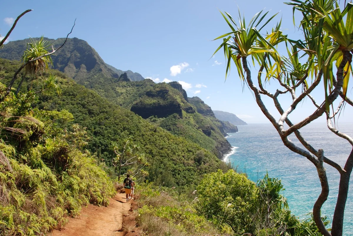
The Kalalau Trail is a legendary route that tests the limits of even the most experienced backpackers. While the total distance of 17.7 kilometres might seem modest to some, the reality of the terrain tells a different story. The trail is a constant series of switchbacks, steep ascents, and knee-jarring descents. There is very little flat ground; you are either climbing out of a valley or descending into one. The path is often narrow, composed of slippery red clay, loose volcanic rock, or crumbling scree. In sections like the infamous "Crawlers Ledge" at the 11-kilometre mark, the trail narrows to a mere foot-width with a vertical drop into the ocean on one side and a solid rock wall on the other. This is a high-stakes environment where concentration is as vital as physical fitness.
The journey begins at Ke'e Beach, at the very end of Highway 560. The first 3.2 kilometres to Hanakapi'ai Valley are accessible to day hikers with a reservation, making this section the most crowded. However, once you cross the Hanakapi'ai Stream and begin the ascent toward Space Rock, the crowds vanish. From this point forward, a valid camping permit is required, and the trail transforms into a true wilderness experience. You will traverse the Hoolulu and Waiahuakua Valleys, moving through dense tropical rainforests where the air is thick with humidity and the scent of wild ginger and guava. The middle section of the trail, particularly around Hanakoa Valley, is often the muddiest and most technically taxing due to the dense canopy and frequent localized rain showers.
The final stretch into Kalalau Valley is a visual crescendo. As you emerge from the forest onto the exposed ridges of the "Red Dirt" section, the full scale of the Na Pali Coast is revealed. The fluted ridges, known as "pali" in Hawaiian, rise nearly 1,000 metres from the sea, their sharp edges softened by a carpet of vibrant green vegetation. The descent into Kalalau Beach is a steep, dusty scramble that eventually levels out into a coastal forest of Java plum and ironwood trees. Reaching the beach feels like stepping back in time; with no roads, no cell service, and no permanent structures, it is one of the few places on Earth where the modern world feels truly distant. The sheer scale of the cliffs surrounding the beach creates a natural amphitheatre that hums with the sound of falling water and crashing waves.
History and Cultural Context
The Kalalau Trail follows the path of an ancient Hawaiian route that connected coastal communities for centuries. Long before European contact, the valleys of the Na Pali Coast were home to thousands of Native Hawaiians who lived in self-sustaining communities. These residents were master agriculturists, transforming the valley floors into intricate systems of "lo'i" (taro patches) irrigated by the abundant mountain streams. The trail was the vital artery that allowed for trade and social connection between the isolated valleys of Hanakapi'ai, Hanakoa, and Kalalau. Evidence of this history is still visible today in the form of stone terraces, house sites, and agricultural walls that have been reclaimed by the jungle.
Kalalau Valley, the largest of these settlements, was inhabited until the early 20th century. It was a place of refuge and spiritual significance. One of the most famous stories associated with the area is that of Koolau the Leper. In the late 1800s, when the Hawaiian government began forcibly relocating people with leprosy to the colony on Molokai, Koolau and his family fled to the inaccessible reaches of Kalalau. He successfully resisted capture by government forces for years, using his knowledge of the rugged terrain to remain hidden. His story remains a powerful symbol of resistance and connection to the land. By the 1920s, the last permanent residents had left the valley, but the cultural footprint remains deep. The entire Na Pali Coast is considered a "wahi pana" (sacred place), and hikers are encouraged to travel with respect for the ancestors who once called these cliffs home.
In the 1960s and 70s, the trail saw a different kind of inhabitant as members of the counter-culture movement sought out the isolation of Kalalau. This led to issues with over-use and environmental degradation, eventually prompting the State of Hawaii to implement the strict permit system that exists today. Modern management by the Department of Land and Natural Resources (DLNR) focuses on balancing the high demand for this bucket-list experience with the critical need to preserve the archaeological sites and fragile ecosystem of the Hāʻena State Park and the Na Pali Coast State Wilderness Park.
Want more background? Read extended notes on history and cultural context → Learn more
Seasonal Highlights and Weather Reality
Weather is the single most important factor in determining the safety and success of a Kalalau trek. Kauai is one of the wettest places on Earth, and the North Shore receives the brunt of the moisture brought by the prevailing trade winds. The trail can transform from a dry, dusty path to a treacherous mud-slide within minutes of a tropical downpour.
Summer (May to September): This is the prime season for hiking the Kalalau Trail. The weather is generally drier, the trail is more stable, and the ocean is calmer. During these months, the sea at Kalalau Beach often recedes to reveal expansive sand flats and accessible sea caves. However, heat and humidity are at their peak. Temperatures can reach 30°C with high humidity, making the steep climbs feel significantly more exhausting. Sun exposure on the ridges is intense, and hikers must be diligent about hydration.
Winter (October to April): This season brings significant challenges. The North Shore of Kauai experiences massive winter swells, with waves often reaching 6 to 10 metres in height. These swells can wash away large sections of the beach at Kalalau, making camping difficult and rendering the sea caves inaccessible. More importantly, winter is the rainy season. Heavy rain leads to flash flooding in the many streams you must cross. Hanakapi'ai Stream, in particular, is notorious for becoming impassable and dangerous during rain events. The trail becomes extremely slippery, and the risk of landslides increases. Hiking during a heavy rain event is strongly discouraged and often results in trail closures.
Regardless of the season, hikers must be prepared for "micro-climates." It may be sunny at the trailhead in Ha'ena but pouring rain in Hanakoa Valley. Always check the local marine and mountain forecasts, but be prepared for the unpredictable nature of the Pacific.
Recommended Itinerary
3-Day Kalalau Trail Itinerary (Standard)
Day 1: Ke'e Beach to Hanakoa Valley
- Distance: 9.7 km
- Elevation gain: ~610 m
- Time: 5–7 hours
- Start early (before 8:00 AM) to avoid the midday heat on the first ascent
- Steep 3.2 km climb and descent to Hanakapi'ai Stream
- Cross Hanakapi'ai Stream (use caution; do not cross if water is high)
- Ascend "Space Rock" for the first major view of the coastline
- Traverse Hoolulu and Waiahuakua Valleys through dense forest
- Arrive at Hanakoa Valley campsite
- Hanakoa offers a shaded, jungle environment with a nearby stream and a 0.8 km side trail to Hanakoa Falls
- This is a good "halfway" point to break up the journey and acclimatise to the humidity
Day 2: Hanakoa Valley to Kalalau Beach
- Distance: 8 km
- Elevation gain: ~450 m
- Time: 4–6 hours
- Depart Hanakoa and enter the most exposed section of the trail
- Navigate "Crawlers Ledge" (Mile 7 / 11.2 km)—take your time and maintain three points of contact
- Cross the "Red Dirt" ridges where the trail is often dry and crumbly
- Descend into Kalalau Valley, passing the 11-mile marker
- Follow the trail through the coastal forest to the beach
- Set up camp in the designated area behind the beach (near the waterfall for water access)
- Spend the afternoon exploring the sea caves or relaxing on the sand
Day 3: Kalalau Beach to Ke'e Beach (The Long Haul)
- Distance: 17.7 km
- Elevation gain: ~1,524 m (cumulative)
- Time: 8–12 hours
- A very early start (dawn) is essential if completing the return in one day
- The return journey feels harder as you must climb back up the steep ridges you descended
- Ensure you have refilled all water at the Kalalau waterfall before departing
- Monitor energy levels; if exhausted, consider an extra night at Hanakoa (if your permit allows)
- Finish at Ke'e Beach and take the shuttle back to your vehicle
Important Notes:
- Permits are required for any travel beyond Hanakapi'ai Valley
- The trail is an "out and back" route; there are no loops
- Emergency evacuations are by helicopter only and are extremely expensive
- Stream crossings are the most dangerous part of the trail during rain
- Cell phone service is non-existent after the first 2 kilometres
Planning and Bookings
Book Your Trip
Everything you need to plan your journey
Accommodation
Find places to stay near Lihue, Kauai
Flights
Search flights to Lihue, Kauai
Essential Preparation
The Kalalau Trail is not a beginner's hike. It requires a high level of cardiovascular fitness, leg strength, and balance. Preparation should begin months in advance, focusing on hill climbing with a weighted pack. Because the trail is so remote, you must be entirely self-sufficient. There are no facilities to purchase food or supplies once you leave the trailhead.
Logistically, you must coordinate three things: your camping permit, your Hāʻena State Park entry/parking, and your flights to Lihue (LIH). Most hikers stay in the towns of Hanalei or Princeville the night before starting. Be aware that Highway 560 is narrow and includes several one-lane bridges; allow extra time for travel. Parking at the trailhead is strictly limited and requires a separate reservation from the camping permit. Most hikers find it easier to use the North Shore Shuttle, which departs from various locations in Princeville and Hanalei.
Trail Accommodation
There are no huts, lodges, or permanent shelters on the Kalalau Trail. This is a primitive wilderness camping experience. You must bring your own tent or lightweight shelter.
Campsite Locations:
- Hanakoa Valley: Located at the 9.7 km mark. This is a forested site on old agricultural terraces. It is damp, shaded, and can be buggy, but it provides essential shelter if you cannot make it to the beach in one day. Facilities include a composting toilet and a small roofed shelter (for emergency use/cooking, not sleeping).
- Kalalau Beach: The primary destination at the end of the 17.7 km trail. Camping is permitted in the forest area immediately behind the beach. Do not camp directly on the sand as high tides and swells can be dangerous. Facilities include composting toilets located at both ends of the camping area.
Facilities Provided:
- Composting toilets (bring your own toilet paper)
- Natural water sources (streams and waterfalls—must be treated)
What is NOT Provided:
- Potable water
- Trash cans (you must pack out all rubbish)
- Bedding or shelters
- Emergency communication devices
Required Gear
- Hiking Boots: High-quality, waterproof boots with aggressive tread are essential. The mud is slick, and the rocks are sharp. Do not attempt this in sneakers or sandals.
- Backpack: A 50–65L pack with a proper suspension system and rain cover.
- Tent/Shelter: A lightweight, waterproof tent. A footprint is recommended due to the abrasive volcanic soil.
- Sleeping System: A lightweight sleeping bag or quilt (rated to 10–15°C) and a sleeping pad for insulation from the damp ground.
- Water Filter: A high-quality filter (like a Sawyer Squeeze or Katadyn BeFree) or purification tablets. Leptospirosis is present in all Hawaiian freshwater; never drink untreated stream water.
- Trekking Poles: Highly recommended for stability on slippery descents and during stream crossings.
- Headlamp: With extra batteries. The jungle gets dark very quickly once the sun sets.
- First Aid Kit: Include blister care (moleskin/Leukotape), antiseptic wipes, and any personal medications.
What to Bring
- Food: Lightweight, calorie-dense meals for the duration of your trip (dehydrated meals, nuts, energy bars). Bring 20% more than you think you need in case of weather delays.
- Water Storage: Capacity to carry at least 3 litres of water at a time. The stretch between Hanakoa and Kalalau is hot and dry.
- Clothing: Moisture-wicking base layers (merino or synthetic), a lightweight rain jacket, and extra socks. Avoid cotton, which stays wet and causes chafing.
- Sun Protection: SPF 50+ sunscreen, a wide-brimmed hat, and UV-rated sunglasses.
- Toiletries: Biodegradable soap, toothbrush, toothpaste, and a small trowel (though toilets are provided, emergencies happen).
- Insect Repellent: Mosquitoes can be intense in the valleys, especially after rain.
- Dry Bags: To keep your sleeping bag and electronics dry during rain or stream crossings.
Permits
Permits for the Kalalau Trail are among the most sought-after in the United States. They are issued by the Hawaii Department of Land and Natural Resources (DLNR) and are mandatory for anyone proceeding past Hanakapi'ai Valley, whether you intend to camp or just hike for the day.
Booking Process:
- Permits are released 90 days in advance on a rolling basis.
- They typically go on sale at 12:00 AM Hawaii Standard Time (HST).
- During peak season, permits often sell out within minutes of being released.
- You must book through the official DLNR online reservation system.
- The permit covers both the trail access and camping at Hanakoa or Kalalau.
Costs:
- Hawaii Residents: US$25 per person, per night.
- Non-Residents: US$35 per person, per night.
- Maximum stay is 5 nights.
Parking and Shuttle: Even with a camping permit, you must still arrange your entry into Hāʻena State Park. If you wish to park a vehicle at the trailhead overnight, you must secure one of the very limited overnight parking spots through the GoHaena website. These are separate from the camping permit. If parking is unavailable, you must book a seat on the North Shore Shuttle. Do not attempt to park on the side of the road outside the park; you will be ticketed and towed.
Other Activities in the Area
Kauai's North Shore offers numerous ways to experience the Na Pali Coast and the surrounding tropical landscape:
- Na Pali Boat Tours: If you cannot get a permit or prefer not to hike, a catamaran or zodiac tour from Hanalei or Port Allen is the best way to see the cliffs from the water. Many tours include snorkelling at Nu'alolo Kai.
- Helicopter Tours: For a truly breathtaking perspective, a "doors-off" helicopter tour provides views of the interior canyons and waterfalls (like Manawaiopuna Falls, featured in Jurassic Park) that are inaccessible by foot.
- Limahuli Garden and Preserve: Located right next to the trailhead, this botanical garden offers a look at native Hawaiian plants and ancient archaeological sites in a stunning valley setting.
- Hanalei Bay: After your hike, relax at one of the world's most beautiful beaches. The town of Hanalei offers excellent dining, surf shops, and a laid-back atmosphere.
- Snorkelling at Tunnels Beach (Makua): One of the best snorkelling spots on the island, featuring a complex reef system and abundant sea life, located just a few kilometres from the Kalalau trailhead.
Safety and Conditions
The "Most Dangerous" Reputation: The Kalalau Trail is frequently cited as one of the most dangerous hikes in the world. This is primarily due to three factors: flash floods, extreme exposure, and falling. Between 1970 and 2010, over 80 people died at Hanakapi'ai Beach alone, mostly due to powerful rip currents. On the trail itself, the dangers are more technical.
Stream Crossings: There are several major stream crossings (Hanakapi'ai, Hoolulu, Waiahuakua, and Hanakoa). During heavy rain, these streams can turn into raging torrents within minutes. If the water is brown and moving fast, or if you can hear boulders rolling on the stream bed, do not cross. Wait for the water to recede, which usually happens within a few hours after the rain stops. Many hikers have been swept away and killed attempting to cross Hanakapi'ai Stream during a flood.
Crawlers Ledge: Located at the 11.2 km mark, this is a section of narrow trail on a sheer rock face. While the rock is generally solid (basalt), it can be slippery when wet. If you have a severe fear of heights, this section will be extremely challenging. Maintain focus, keep your pack weight centred, and move slowly. In high winds, this section becomes significantly more hazardous.
Leptospirosis: This is a bacterial disease found in tropical freshwater worldwide. It enters the body through cuts or mucous membranes. Never swim in pools with open wounds, and never drink the water without boiling or filtering it with a high-quality filter. Symptoms include high fever, headache, and muscle aches.
Heat and Dehydration: The combination of intense tropical sun and high humidity can lead to rapid dehydration and heat exhaustion. There is very little shade on the ridges. Start your hiking days as early as possible and carry more water than you think you need for the exposed sections.
Side Trips and Points of Interest
Hanakapi'ai Falls: A popular 3.2 km (one-way) detour from Hanakapi'ai Beach. The trail leads deep into the valley to a spectacular 91-metre waterfall that plunges into a deep, cold pool. The trail is often very muddy and requires multiple stream crossings, but the sight of the falls framed by towering green walls is unforgettable.
Hanakoa Falls: A shorter detour (about 0.8 km) from the Hanakoa campsite. This multi-tiered waterfall is less visited than Hanakapi'ai and offers a more serene, secluded experience. It is a great place to rinse off the trail dust before settling in for the night.
Big Kalalau Valley: Once you reach the beach, the trail continues into the back of the valley. Exploring the old agricultural terraces and finding the hidden pools in the Kalalau Stream is a highlight for those staying multiple nights. The valley is immense, and the scale of the cliffs from the valley floor is humbling.
The Sea Caves: At the far end of Kalalau Beach (during summer months when the sand is present), you can walk into several large sea caves. One cave features a freshwater "shower" dripping from the ceiling. Be extremely careful of falling rocks and never enter the caves if the swell is high.
Leave No Trace
The Na Pali Coast is a fragile ecosystem and a significant archaeological site. With thousands of people attempting this hike every year, the cumulative impact is enormous. Adhering to Leave No Trace principles is not just a suggestion; it is a requirement for the survival of the trail.
Key Principles for Kalalau:
- Pack it in, Pack it out: This includes everything. Orange peels, nut shells, and especially used toilet paper. There is no trash service in the wilderness. If you see trash left by others, please help by packing it out.
- Respect Archaeological Sites: Do not move stones, climb on walls, or enter marked sensitive areas. These are gravesites and homes of the ancestors of the Hawaiian people.
- Proper Waste Disposal: Use the composting toilets provided at Hanakoa and Kalalau. If you must go between sites, dig a "cathole" at least 15–20 cm deep and at least 60 metres away from any water source.
- No Campfires: Fires are strictly prohibited. Use a lightweight backpacking stove for cooking. Fires damage the soil and pose a massive risk to the dry ridges.
- Protect the Water: Do not use soap (even biodegradable) directly in the streams. Carry water 60 metres away from the source to wash yourself or your dishes.
- Don't Feed Wildlife: This includes the feral goats and cats. Feeding them disrupts their natural behaviour and can lead to increased erosion and damage to native plants.