Julier Pass to Piz Surgonda: A Swiss Alpine Challenge
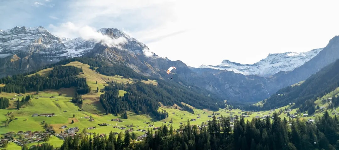
The Julier Pass to Piz Surgonda hike is a demanding yet incredibly rewarding day walk situated in the heart of the Swiss Alps, offering a spectacular immersion into high-altitude alpine scenery. This route is not for the faint of heart, combining significant elevation gain with rugged terrain to deliver an experience that tests physical endurance and rewards with breathtaking panoramic views. Starting from the historic Julier Pass, a vital trans-Alpine route for centuries, the trail ascends steeply towards the summit of Piz Surgonda, a prominent peak that stands sentinel over the Engadin valley. The journey traverses diverse landscapes, from alpine meadows dotted with wildflowers in summer to rocky scree slopes and exposed ridges, culminating in a summit vista that encompasses a vast swathe of the surrounding mountain ranges, including iconic peaks of the Bernina Alps.
- Distance: 12.5 km one-way
- Elevation Gain: 1200 m
- Duration: 6–8 hours
- Difficulty: Challenging
- Best Time: July to September
- Highest Point: Piz Surgonda (approx. 3,000 m)
- Starting Point: Julier Pass (2,284 m)
- Ending Point: Descends towards the Engadin valley, typically ending near a transport link.
Overview
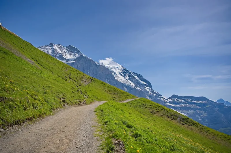
This challenging ascent from Julier Pass to Piz Surgonda is a quintessential alpine adventure, designed for experienced hikers seeking a substantial day's challenge with unparalleled rewards. The route begins at the Julier Pass, a historically significant mountain pass that has served as a crucial link between the Engadin valley and the rest of Switzerland for over two millennia. The pass itself, at 2,284 metres, is already a high-altitude starting point, offering initial views of the rugged landscape that lies ahead. From here, the trail embarks on a relentless, steep climb, gaining over 1,200 metres in elevation to reach the summit of Piz Surgonda. This ascent is a true test of stamina, winding through varied terrain that shifts from open alpine pastures, vibrant with wildflowers during the short summer months, to increasingly rocky and scree-covered slopes as you gain altitude.
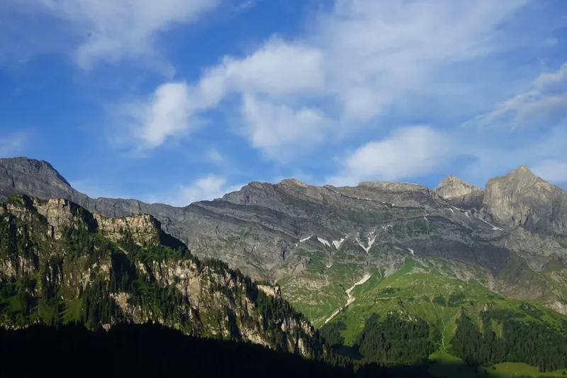
The higher you climb, the more dramatic the scenery becomes. The air thins, and the scale of the surrounding mountain ranges becomes apparent. You'll traverse sections that require careful footwork and a good head for heights, particularly as you approach the summit ridge. The summit of Piz Surgonda, standing at approximately 3,000 metres, offers a truly spectacular 360-degree panorama. On a clear day, the views stretch across the Engadin valley, revealing the chain of lakes that define its beauty, and extending to the majestic peaks of the Bernina massif, including Piz Bernina and Piz Morteratsch. The sense of accomplishment upon reaching the summit is immense, amplified by the sheer grandeur of the alpine world laid out before you. The descent typically follows a similar path or a variation that leads back towards accessible transport links in the valley below, offering a different perspective on the terrain you conquered.
This hike is best undertaken during the summer months, typically from July to September, when the snow has melted from the higher reaches of the trail, and the weather is generally more stable. However, alpine weather is notoriously unpredictable, and hikers must be prepared for rapid changes, including sudden storms, strong winds, and temperature drops, even in mid-summer. The Julier Pass to Piz Surgonda hike is a serious undertaking that demands a good level of fitness, robust hiking experience, and appropriate gear, but for those who meet its demands, it offers an unforgettable encounter with the raw beauty of the Swiss Alps.
History and Cultural Context
The Julier Pass (Julierpass in German) is steeped in history, having been a vital artery for trade, travel, and military movements for centuries. Its strategic importance is evident from Roman times, when it served as a key route connecting the Rhone Valley with the Engadin and further into Italy. The pass was particularly crucial for the transport of goods, including salt, wine, and textiles, between the northern and southern sides of the Alps. The Romans likely established a rudimentary track, which was later improved and maintained by various rulers and communities over the ensuing centuries. The pass's name is believed to derive from the Roman emperor Julius Caesar, though concrete evidence is scarce, it points to its long-standing significance.
During the Middle Ages and into the early modern period, the Julier Pass remained a critical link for the transport of goods and people. It was part of the network of routes that facilitated the economic and cultural exchange between the Alpine regions. The pass also played a role in military conflicts, with various powers vying for control of this strategic high-altitude crossing. The construction of more modern roads in the 19th and 20th centuries, including the paved road that exists today, has made the pass more accessible, but it retains its historical charm and significance.
The Engadin valley itself, which the hike overlooks, has a rich cultural heritage. The Romansh language, one of Switzerland's four national languages, is still spoken here, a testament to the region's ancient linguistic roots. The valley has also been a favoured destination for artists, writers, and royalty for centuries, drawn by its dramatic landscapes and pristine natural beauty. The ascent to Piz Surgonda, while a modern-day hiking challenge, traverses terrain that has been known and used by humans for millennia, connecting the present-day hiker to a deep and enduring history of human endeavour in the Alps.
Seasonal Highlights and Weather Reality
The optimal season for hiking the Julier Pass to Piz Surgonda is during the summer months, typically from July to September. During this period, the snow has generally receded from the higher elevations, making the trail accessible and safer for hikers. The alpine meadows are usually in full bloom, offering a vibrant display of wildflowers, and the days are longer, providing ample daylight for the strenuous ascent and descent.
July: This month often marks the full opening of the higher trails. Wildflowers are abundant, and the weather can be warm and sunny, though afternoon thunderstorms are increasingly common. The landscape is lush and green.
August: Similar to July, August offers good hiking conditions. The wildflowers may begin to fade slightly, but the overall scenery remains spectacular. This is a popular month for hiking, so expect more people on the trails, especially on weekends.
September: This month can offer some of the most stable weather, with clearer skies and fewer thunderstorms. The autumn colours begin to appear in the lower valleys, adding a different dimension to the scenery. However, temperatures start to drop, and there is an increased risk of early snowfalls at higher altitudes, especially towards the end of the month. The days are also shorter.
Weather Reality: It is crucial to understand that alpine weather is highly unpredictable. Even during the peak summer months, conditions can change rapidly. Hikers must be prepared for:
- Sudden Storms: Thunderstorms can develop quickly in the afternoons, bringing heavy rain, lightning, and strong winds.
- Temperature Fluctuations: Temperatures can drop significantly with altitude and changes in weather. Even on a warm day, the summit can be cold and windy.
- Snow: Early or late season snow can make the trail impassable or dangerous, even if the pass itself is clear.
- Wind: Strong winds are common at higher elevations and can make exposed sections challenging and increase the risk of hypothermia.
Always check the weather forecast immediately before setting out and be prepared to turn back if conditions deteriorate.
Recommended Itinerary
Julier Pass to Piz Surgonda: A Challenging Day Hike
Early Morning: Julier Pass (2,284 m) - Start of the Ascent
- Time: 7:00 AM - 8:00 AM
- Activity: Arrive at Julier Pass. Ensure you have all your gear organised and have had a substantial breakfast. Check the weather forecast one last time. Begin the hike by following the marked trail heading towards Piz Surgonda. The initial section may involve traversing open alpine meadows or following a well-defined path that begins to steepen.
- Key Waypoints: Julier Pass village/parking area, initial trail markers.
Morning: Steep Ascent through Alpine Meadows
- Time: 8:00 AM - 11:00 AM
- Distance: Approximately 4-5 km
- Elevation Gain: 600-700 m
- Activity: The trail becomes significantly steeper as you leave the immediate vicinity of the pass. You will be climbing through beautiful alpine meadows, which, depending on the season, will be carpeted with wildflowers. The path is likely to be rocky and uneven in places, requiring concentration and a steady pace. Take short breaks to hydrate and admire the expanding views of the Engadin valley below.
- Key Waypoints: Transition from pastureland to rockier terrain, potential small streams for water collection (treatment recommended).
Midday: Rocky Terrain and Ridge Approaches
- Time: 11:00 AM - 1:00 PM
- Distance: Approximately 3-4 km
- Elevation Gain: 400-500 m
- Activity: The terrain becomes more rugged and scree-covered. You will be navigating steeper slopes, possibly with some scrambling sections. The path may be less distinct in places, relying on cairns or trail markers. The air will be noticeably thinner, and the wind can pick up. This section requires good balance and sure-footedness.
- Key Waypoints: Transition to scree slopes, exposed sections, potential for encountering snow patches early or late in the season.
Afternoon: Summit Push and Panoramic Views
- Time: 1:00 PM - 2:30 PM
- Distance: Approximately 1-2 km
- Elevation Gain: 100-200 m
- Activity: The final push to the summit of Piz Surgonda. This section is often the most exposed and can involve navigating rocky outcrops. Upon reaching the summit (approx. 3,000 m), take ample time to rest, refuel, and soak in the breathtaking 360-degree views. Identify surrounding peaks and the Engadin lakes.
- Key Waypoints: Summit cairn/marker of Piz Surgonda.
Late Afternoon: Descent and Return to Transport
- Time: 2:30 PM - 6:30 PM
- Distance: Approximately 5-6 km
- Elevation Loss: 1200 m
- Activity: Begin the descent. This will likely retrace your steps or follow a slightly different route down the mountain. The descent can be as challenging as the ascent, particularly on the knees, and requires careful footing on loose scree and rocky sections. Aim to reach the Julier Pass road or a nearby bus stop before dusk.
- Key Waypoints: Return to Julier Pass road, potential bus stops.
Important Notes:
- This is a strenuous hike requiring excellent physical fitness and hiking experience.
- Carry sufficient water and food, as there are no facilities on the trail.
- Be prepared for rapidly changing weather conditions.
- Wear sturdy, broken-in hiking boots and dress in layers.
- Inform someone of your hiking plans and expected return time.
Planning and Bookings
Book Your Trip
Everything you need to plan your journey
Accommodation
Find places to stay near St. Moritz
Flights
Search flights to St. Moritz
Essential Preparation
The Julier Pass to Piz Surgonda hike is a challenging day walk that requires thorough preparation. Given its remote alpine location and significant elevation gain, fitness is paramount. Hikers should be comfortable with sustained uphill climbs and descents over several hours. Prior experience with mountain hiking, including navigating uneven terrain and dealing with variable weather, is highly recommended. Base town information is crucial for logistics; the nearest major hub is St. Moritz, a well-known resort town in the Engadin valley. St. Moritz offers a wide range of accommodation, from luxury hotels to more budget-friendly guesthouses, as well as excellent transport links. Access to Julier Pass itself is primarily via public transport (buses from St. Moritz) or by car. Parking is available at Julier Pass, but it can be limited, especially during peak season. It is advisable to check public transport schedules in advance and plan your journey to the trailhead. The road to Julier Pass is paved and generally well-maintained, but can be subject to closures due to snow in winter and spring, and potentially due to weather events at other times. Always verify road conditions before travelling.
Trail Accommodation
This is a day hike requiring no overnight accommodation. Hikers will start and finish their journey within a single day, returning to their base accommodation in the Engadin valley or continuing their travels.
Required Gear
- Sturdy Hiking Boots: Waterproof, with good ankle support and excellent grip. Essential for navigating rocky and scree-covered terrain.
- Waterproof and Windproof Outerwear: A high-quality waterproof jacket and trousers are non-negotiable due to the unpredictable alpine weather.
- Warm Layers: Multiple layers of synthetic or merino wool clothing (base layer, mid-layer fleece or insulated jacket) are crucial for adapting to temperature changes. A warm hat and gloves are essential, even in summer.
- Navigation Tools: A detailed topographic map of the area, a compass, and a GPS device or smartphone with offline maps are vital. Trail markers can be sparse in some sections.
- Head Torch: With fresh batteries, in case of unexpected delays or an early start/late finish.
- First-Aid Kit: Comprehensive kit including blister treatment, pain relievers, bandages, antiseptic wipes, and any personal medications.
- Sun Protection: High SPF sunscreen, sunglasses, and a wide-brimmed hat or cap. The sun's intensity is significantly higher at altitude.
- Backpack: A comfortable daypack (30-40 litres) to carry all essentials.
What to Bring
- Food: High-energy snacks and a packed lunch. There are no food services on the trail. Consider items like energy bars, nuts, dried fruit, sandwiches, and chocolate.
- Water: At least 2-3 litres of water per person. Water sources may be available along the lower parts of the trail, but purification (filter or tablets) is strongly recommended.
- Toiletries: Small personal items, including toilet paper and hand sanitiser.
- Emergency Shelter: A lightweight emergency bivy bag or space blanket.
- Trekking Poles: Highly recommended for stability on ascents and descents, and to reduce strain on knees.
- Mobile Phone: Fully charged, for emergencies. Note that mobile signal can be intermittent in the mountains.
- Cash: For potential bus fares or small purchases if needed.
Permits
No specific permits are required for hiking the Julier Pass to Piz Surgonda trail. As this is a public hiking route within the Swiss Alps and not part of a national park with strict access controls like some other famous trails, general access is free. However, it is always advisable to check for any local advisories or temporary restrictions that might be in place due to weather conditions, maintenance, or other unforeseen circumstances. Information can usually be found through local tourism offices or national park websites if applicable to the specific region.
Other Activities in the Area
The Engadin valley, with St. Moritz as its jewel, offers a wealth of activities beyond the Julier Pass to Piz Surgonda hike, catering to a wide range of interests:
- Lake Exploration: St. Moritz, Silvaplana, and Sils lakes offer opportunities for sailing, windsurfing, paddleboarding, and scenic boat trips. The lakeside promenades are perfect for leisurely strolls.
- Mountain Biking: The region boasts an extensive network of mountain biking trails, from gentle valley routes to challenging downhill tracks. Bike rental is readily available in St. Moritz and surrounding villages.
- Cable Cars and Gondolas: Numerous lifts provide access to higher altitudes for panoramic views, easier walks, and access to mountain restaurants. Popular options include the Corviglia, Diavolezza, and Lagalb cable cars.
- Museums and Culture: Explore the Engadin Museum in St. Moritz to learn about the region's unique history and culture, including the Romansh language and traditions.
- Wellness and Spas: St. Moritz is renowned for its luxury spas and wellness centres, offering a perfect way to relax and rejuvenate after a day of hiking.
- Winter Sports (Seasonal): During winter, the Engadin transforms into a world-class destination for skiing, snowboarding, cross-country skiing, and winter hiking.
- Scenic Drives: The roads through the Engadin, including the Julier Pass itself, offer spectacular driving experiences with numerous viewpoints.
Safety and Conditions
Pre-Trip Checks:
- Weather Forecast: Always check the most up-to-date mountain weather forecast for the Julier Pass and Piz Surgonda region immediately before your hike. Websites like MeteoSwiss or local alpine club forecasts are reliable sources. Be prepared for rapid changes.
- Trail Conditions: While this is a popular route, check with local tourist information offices or mountain guides for any specific trail advisories, especially regarding snow cover early or late in the season, or any temporary closures.
- Route Familiarisation: Study your map and GPS route beforehand. Understand the key landmarks, potential hazards, and bailout points.
On the Trail Hazards:
- Altitude: Piz Surgonda is approximately 3,000 metres. Be aware of the symptoms of altitude sickness (headache, nausea, dizziness). Ascend gradually, stay hydrated, and descend if symptoms worsen.
- Terrain: The trail involves steep ascents and descents, loose scree, and rocky sections. Proper footwear and careful foot placement are essential to prevent slips and falls.
- Weather: Alpine weather can change dramatically and without warning. Be prepared for sudden drops in temperature, strong winds, heavy rain, fog, and even snow. Hypothermia is a risk even in summer if you become wet and cold.
- Navigation: While the trail is generally marked, visibility can be severely reduced in fog or cloud. Relying solely on trail markers can be risky. Always carry and know how to use your map and compass/GPS.
- Isolation: Although a day hike, you will be in a remote alpine environment. Mobile phone reception can be unreliable. Inform someone of your hiking plans, your expected return time, and your route. Consider carrying a personal locator beacon (PLB) for emergencies.
- Sun Exposure: The sun's rays are much stronger at high altitudes. Protect yourself from sunburn and heatstroke.
Emergency Procedures:
- In case of emergency, call the Swiss emergency number: 144 (ambulance) or 112 (general European emergency number).
- If you encounter someone injured, do not move them unless they are in immediate danger. Provide first aid and call for professional help.
- If you are lost, stay calm, try to retrace your steps to a known point, or stay put and signal for help if possible.
Side Trips and Points of Interest
Julier Pass Historical Markers: As you begin your hike, take a moment to appreciate the historical significance of Julier Pass itself. Look for any interpretive signs or historical markers that detail its long history as a trade route and a passage through the Alps. The pass has been a vital link for centuries, and its landscape bears the subtle imprint of this long human history.
Alpine Flora and Fauna: The lower slopes of the trail, particularly in July and August, are a haven for alpine wildflowers. Keep an eye out for species like gentians, edelweiss (though rare), alpine roses, and various saxifrages. If you are quiet and observant, you might also spot marmots whistling their alarm calls, chamois grazing on steep slopes, or various alpine birds.
Panoramic Viewpoints: The entire ascent offers increasingly spectacular viewpoints. As you gain altitude, the Engadin valley unfolds below, revealing the chain of lakes (Lake St. Moritz, Lake Silvaplana, Lake Sils) and the charming villages nestled within. Each significant gain in elevation provides a new perspective and a rewarding vista.
Summit of Piz Surgonda: The ultimate point of interest is the summit itself. At approximately 3,000 metres, it offers an unparalleled 360-degree panorama. On a clear day, you can identify numerous prominent peaks of the Bernina Alps, including Piz Bernina (the highest peak in the Eastern Alps), Piz Morteratsch, and the Piz Palü massif. The vastness of the alpine landscape from this vantage point is truly awe-inspiring.
Geological Features: Observe the varied geological formations along the trail, from the glacial moraines and scree slopes to the exposed rock faces. These features tell the story of the region's glacial past and ongoing geological processes.
Leave No Trace
The Julier Pass to Piz Surgonda hike traverses a sensitive alpine environment. Adhering to Leave No Trace principles is crucial to preserve its natural beauty and ecological integrity for future visitors and for the health of the ecosystem itself.
- Plan Ahead and Prepare: Understand the trail, weather, and your own capabilities. Pack appropriately to avoid needing to leave anything behind or impacting the environment.
- Travel and Camp on Durable Surfaces: Stick to the marked trail at all times. Avoid cutting switchbacks, as this causes erosion and damages fragile vegetation. When taking breaks, choose established spots rather than creating new ones.
- Dispose of Waste Properly: Pack out everything you pack in. This includes all food scraps, wrappers, and any other litter. Use designated toilet facilities where available, or if not, dig a cathole at least 60 metres away from water sources, trails, and campsites, and bury human waste. Pack out used toilet paper.
- Leave What You Find: Do not take rocks, plants, or any other natural objects. Leave them for others to enjoy and for the ecosystem to thrive.
- Minimise Campfire Impacts: Campfires are generally not permitted on this day hike, and are highly discouraged in alpine environments due to their lasting impact. If you must use a stove, ensure it is a lightweight, portable stove and use it on a durable surface.
- Respect Wildlife: Observe wildlife from a distance. Do not feed animals, as this can disrupt their natural behaviours and diets, and can be harmful to their health.
- Be Considerate of Other Visitors: Keep noise levels down, yield to uphill hikers, and be courteous to fellow trail users.
By following these principles, you help ensure that the stunning alpine landscapes of the Engadin remain pristine and enjoyable for generations to come.