Juan de Fuca Marine Trail - Vancouver Island's Rugged Coastal Odyssey
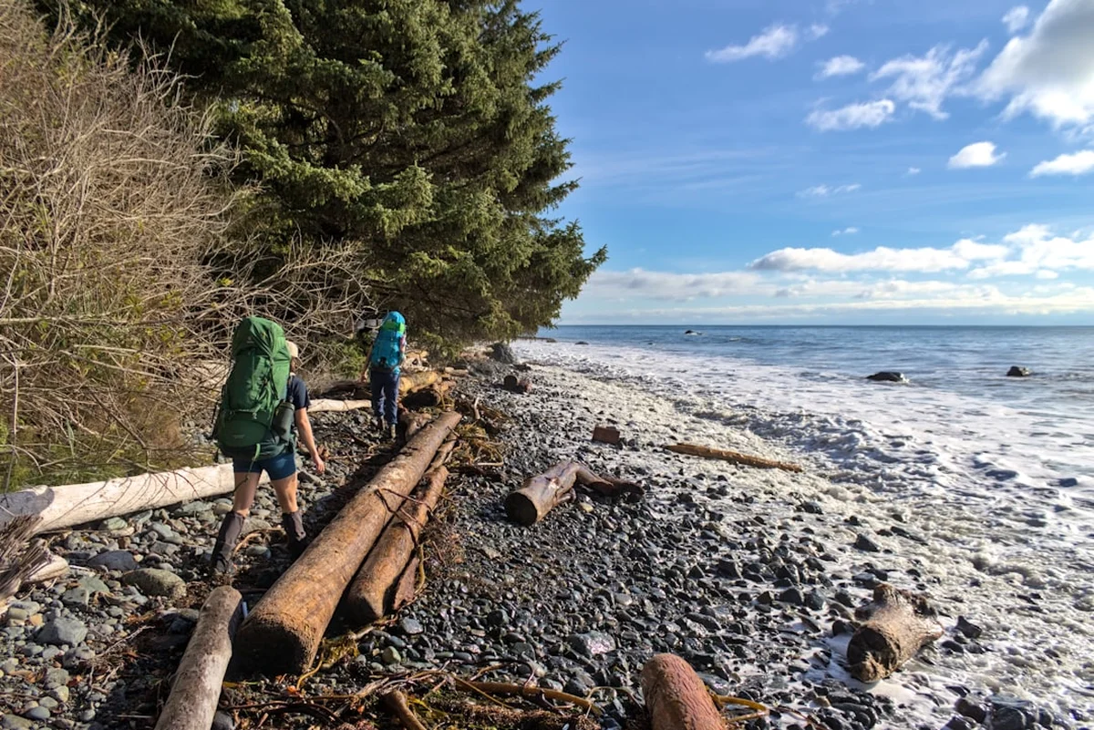
The Juan de Fuca Marine Trail is a world-class coastal trekking experience stretching 47 kilometres along the southwestern shores of Vancouver Island, British Columbia. Carved through ancient temperate rainforests and tracing the jagged edge of the Pacific Ocean, this trail offers a raw, unscripted encounter with the Canadian wilderness. Unlike its more famous and highly regulated neighbour, the West Coast Trail, the Juan de Fuca Marine Trail provides a more accessible but equally demanding challenge, featuring steep climbs over muddy headlands, balancing acts across slippery logs, and breathtaking traverses of pebble beaches and sandstone shelves. It is a journey through a landscape defined by the relentless power of the sea, where the mist of the Pacific meets the emerald canopy of Sitka spruce and Western red cedar.
- Distance: 47.0 km one-way
- Duration: 4–6 days
- Season: May to September (accessible year-round, but winter conditions are extreme)
- Accommodation: Backcountry beach and forest campsites (no huts)
- Highest point: Approximately 150 metres (multiple steep ascents and descents)
- Difficulty: Moderate to Strenuous (due to mud, roots, and elevation changes)
- Direction: Can be hiked in either direction (China Beach to Botanical Beach or vice versa)
Overview
The Juan de Fuca Marine Trail is often described as the "wilder, younger sibling" of the West Coast Trail. While it shares the same dramatic coastline and challenging terrain, it offers a distinct experience characterised by its flexibility and ruggedness. The trail is part of the Juan de Fuca Provincial Park, established in 1994 to protect this sensitive coastal ecosystem and provide a recreational legacy for the Commonwealth Games. It serves as a sanctuary for a diverse array of wildlife, from bald eagles circling the thermals to grey whales migrating just offshore and black bears foraging in the intertidal zones.
The terrain is notoriously deceptive. While the maximum elevation rarely exceeds 150 metres above sea level, the trail is a constant series of "ups and downs" as it navigates the deep ravines and high headlands that characterise the coast. Hikers must contend with a complex network of exposed roots, deep mud pits that can swallow a boot whole, and slippery boardwalks that require constant focus. The weather is a primary protagonist in any Juan de Fuca story; the region is part of a temperate rainforest that receives significant rainfall even in the summer months. When the sun breaks through the coastal fog, the landscape is transformed into a shimmering paradise of turquoise water and deep green forest. When the rain falls, the trail becomes a test of endurance and gear, where the smell of damp cedar and the roar of the surf create an atmosphere of profound isolation.
One of the most unique aspects of the trail is the transition between forest and beach. Hikers will spend hours navigating the dense, moss-draped interior before descending steep wooden ladders or muddy switchbacks to emerge onto expansive beaches. These beaches—ranging from the fine sands of Mystic Beach to the surge-carved sandstone of Botanical Beach—serve as both campsites and thoroughfares. However, the ocean is a powerful force here, and many sections of the beach are impassable at high tide. Success on the Juan de Fuca Marine Trail requires a keen understanding of the tide tables and a deep respect for the volatile nature of the Pacific Northwest coast.
History and Cultural Context
The Juan de Fuca Marine Trail traverses the traditional territories of the Pacheedaht, Scia'new (Beecher Bay), and T'Sou-ke First Nations. For thousands of years, these coastal peoples have lived in harmony with this land, utilizing the rich marine resources and the vast forests for sustenance, medicine, and spiritual practice. The trail itself follows portions of ancient travel routes used by Indigenous communities to move between seasonal villages and harvesting sites. To the First Nations, this coastline is not just a recreational path but a living cultural landscape, filled with oral histories and ancestral connections that predate European arrival by millennia.
The maritime history of the region is equally dramatic and often tragic. The waters off the Juan de Fuca Strait are part of the "Graveyard of the Pacific," a stretch of coastline notorious for its treacherous reefs, unpredictable currents, and dense fog. Hundreds of ships have met their end along these shores over the past two centuries. The trail provides glimpses into this past, with names like "Shipwreck Point" serving as somber reminders of the vessels lost to the sea. In the late 19th and early 20th centuries, telegraph lines were strung along this coast to provide a communication link for shipwreck survivors, and parts of the modern trail follow the old "lifesaving" paths cleared by early settlers and lighthouse keepers.
The formal creation of the Juan de Fuca Marine Trail as a continuous hiking route was a collaborative effort between the British Columbia government, local communities, and outdoor enthusiasts. It was officially opened in 1994 as part of the Commonwealth Nature Legacy, ensuring that this spectacular stretch of Vancouver Island's coastline would remain protected from industrial development and accessible to the public. Today, the trail stands as a testament to the enduring allure of the wild coast and the ongoing importance of preserving both natural biodiversity and Indigenous heritage.
Want more background? Read extended notes on history and cultural context → Learn more
Seasonal Highlights and Weather Reality
The Juan de Fuca Marine Trail is technically open year-round, but the experience varies dramatically depending on the month. The "prime" season is from May to September, when the weather is most stable and the trail is at its driest. However, "dry" is a relative term on Vancouver Island; hikers should be prepared for rain and mud regardless of the forecast.
Spring (May to June): This is a period of vibrant growth. The forest is a brilliant shade of lime green as new needles emerge on the hemlocks and firs. Wildflowers begin to bloom in the coastal meadows, and the birdlife is exceptionally active. Trail conditions can be very muddy during this time as the winter rains linger in the soil. Temperatures are cool, typically ranging from 8°C to 15°C.
Summer (July to August): These are the busiest and driest months. The coastal fog, known locally as "June Gloom" (which often persists into July), frequently rolls in during the morning and clears by mid-afternoon. This is the best time for spotting whales from the shore and enjoying the sunset from the beach campsites. Temperatures are mild, rarely exceeding 22°C due to the cooling influence of the ocean.
Autumn (September to October): September can be one of the most beautiful months on the trail, with crisp air and fewer crowds. However, by October, the frequency of Pacific storms increases significantly. These storms bring heavy rain and high winds, making beach camping difficult and forest travel hazardous due to falling branches.
Winter (November to April): Only experienced coastal hikers should attempt the trail in winter. The region receives massive amounts of precipitation, and the trail becomes a series of deep mud bogs and swollen creek crossings. High tides and winter storm surges can make many beach sections completely impassable and extremely dangerous. Daylight hours are short, and hypothermia is a constant risk in the damp, cold environment.
Recommended Itinerary
5-Day Juan de Fuca Trail Itinerary (North to South)
Day 1: Botanical Beach to Payzant Creek
- Distance: 7 km
- Elevation gain: 150 m
- Time: 3–4 hours
- Start at the Botanical Beach trailhead near Port Renfrew.
- Explore the famous tide pools at Botanical Beach (check tide tables for low tide).
- The trail enters the forest, navigating through massive Sitka spruce and Western hemlock.
- Relatively moderate terrain compared to later sections, but expect roots and some mud.
- Arrive at Payzant Creek campsite, a forested site located above a scenic creek.
- This short day allows for a slow start and plenty of time to admire the geological wonders of the shoreline.
Day 2: Payzant Creek to Sombrio Beach
- Distance: 13 km
- Elevation gain: 350 m
- Time: 5–7 hours
- A more demanding day with significant elevation changes as the trail crosses several deep ravines.
- Pass through the Little Kuitshe Creek campsite (an alternative stopping point).
- The trail offers occasional glimpses of the ocean through the dense canopy.
- Descend onto the cobblestones of Sombrio Beach, one of the most popular spots on the trail.
- Explore the "hidden" waterfall in a narrow slot canyon at the east end of the beach.
- Camp on the beach and enjoy the sound of the surf and the sight of surfers catching waves.
Day 3: Sombrio Beach to Chin Beach
- Distance: 8 km
- Elevation gain: 400 m
- Time: 4–6 hours
- Do not be fooled by the short distance; this is one of the most difficult sections of the trail.
- The trail climbs steeply out of Sombrio and stays high on the headlands.
- Expect "The Mud" – deep sections of the trail that require careful navigation.
- Cross the spectacular Loss Creek suspension bridge, hanging high above the canyon floor.
- Descend a series of steep switchbacks to Chin Beach.
- Chin Beach is a beautiful, long pebble beach with several designated camping areas and a sea cave.
Day 4: Chin Beach to Bear Beach
- Distance: 11 km
- Elevation gain: 450 m
- Time: 6–8 hours
- This is the most strenuous section of the entire trail, often referred to as the "crux."
- The trail involves constant, steep ascents and descents as it crosses numerous ravines.
- Footing is often difficult due to slippery roots and loose soil.
- Pass through the "Doctor's Cabin" area (historic site).
- Arrive at Bear Beach, which offers multiple camping areas spread across a long stretch of sand and gravel.
- Bear Beach is known for its stunning views of the Olympic Mountains across the strait in Washington State.
Day 5: Bear Beach to China Beach (Trailhead)
- Distance: 8 km
- Elevation gain: 250 m
- Time: 3–5 hours
- The final stretch involves a climb out of Bear Beach followed by a traverse of the forest.
- Pass the Mystic Beach junction and descend the stairs to Mystic Beach to see the iconic waterfall falling directly onto the sand.
- Cross the final suspension bridge over Pete Wolfe Creek.
- The trail widens and becomes easier as you approach the China Beach day-use area and trailhead.
- Finish the journey and arrange for a shuttle or transport back to Victoria or Port Renfrew.
Important Notes:
- Tide tables are mandatory; several beach sections are impassable at high tide.
- The trail can be hiked in 4 days by strong hikers, but 5 days allows for a better pace.
- Water must be treated at all campsites.
- Bear caches are provided at all designated campsites; use them for all food and scented items.
- The West Coast Trail Express shuttle provides seasonal transport between trailheads.
Planning and Bookings
Book Your Trip
Everything you need to plan your journey
Accommodation
Find places to stay near Victoria
Flights
Search flights to Victoria
Essential Preparation
The Juan de Fuca Marine Trail requires a high level of physical fitness and mental preparedness. While it does not require the mandatory orientation session of the West Coast Trail, it is no less dangerous for the unprepared. Hikers must be comfortable navigating slippery, uneven terrain while carrying a full multi-day pack. Coordination of transport is the most critical logistical hurdle. Most hikers park at one end and use the West Coast Trail Express shuttle to reach their starting trailhead. Victoria is the primary hub for supplies, gear rentals, and pre-hike accommodation.
Before setting foot on the trail, you must study the tide tables for the specific dates of your hike. Several sections, particularly between Bear Beach and Chin Beach, and around Sombrio, have "tide problems" where the trail is cut off by the rising ocean. Attempting to bypass these sections during a high tide can result in being trapped against cliffs or swept away by surge. Always have a backup plan and be prepared to wait for the tide to recede.
Trail Accommodation
There are no huts or roofed accommodations on the Juan de Fuca Marine Trail. All overnight stays are at designated backcountry campsites. These sites are a mix of forest-based clearings and beach camping areas.
Campsite Locations:
- Mystic Beach (Beach camping)
- Bear Beach (Beach and forest camping)
- Chin Beach (Beach and forest camping)
- Sombrio Beach (East, Centre, and West beach camping)
- Little Kuitshe Creek (Forest camping)
- Payzant Creek (Forest camping)
Facilities Provided:
- Pit toilets (bring your own toilet paper)
- Metal bear-proof food lockers (caches)
- Designated tent pads in forest sites; open camping on beaches
- Access to creek water (must be treated)
What is NOT Provided:
- Potable water
- Trash cans (Pack it in, pack it out)
- Firewood (Fires are only permitted on beaches below the high-tide line, and only when no fire bans are in place)
- Cell service or emergency phones
Costs: Backcountry camping fees are approximately $10.00 per person, per night. These must be paid via the BC Parks West Coast Trail/Juan de Fuca registration system online before you arrive.
Required Gear
- Sturdy hiking boots - Waterproof with excellent ankle support and deep lugs for mud.
- Gaiters - Essential for keeping mud and debris out of your boots.
- Waterproof jacket and trousers - High-quality breathable shells (Gore-Tex or similar) are mandatory.
- Backpack - 50–70L with a waterproof liner or high-quality rain cover.
- Tide Table - A printed copy of the current Port Renfrew tide table is a safety requirement.
- Tent - A lightweight, 3-season waterproof tent with a full fly.
- Sleeping system - A sleeping bag rated to at least 0°C and a sleeping pad for insulation from the damp ground.
- Trekking poles - Highly recommended for stability on slippery roots and during creek crossings.
- Navigation - Topographic map and compass (GPS is a useful backup, but canopy cover can be thick).
What to Bring
- Food - Lightweight, high-calorie meals for the duration of your trip, plus one extra day of emergency rations.
- Water treatment - A high-quality filter (hollow fibre or ceramic) or chemical treatment (tabs/drops).
- Stove and fuel - Lightweight canister or liquid fuel stove (no cooking facilities on trail).
- Bear-resistant food storage - While caches are provided, a dry bag for your food is necessary to keep it organised and dry inside the locker.
- First aid kit - Including blister care (moleskin/Leukotape), antiseptic, and any personal medications.
- Headlamp - With extra batteries.
- Sun protection - Sunscreen and sunglasses for exposed beach sections.
- Clothing layers - Merino wool or synthetic base layers (no cotton), a fleece or down mid-layer, and extra socks.
- Repair kit - Duct tape, multi-tool, and sleeping pad patches.
Permits
Unlike the West Coast Trail, the Juan de Fuca Marine Trail does not have a limited entry quota or a complex reservation system for start dates. However, all overnight hikers are required to purchase a Backcountry Camping Permit through the BC Parks website. This permit acts as your registration and ensures that the park receives the necessary funding for trail maintenance and facility upkeep.
Permit Process:
- Visit the BC Parks Reservation Service website.
- Select "Backcountry" and then "Juan de Fuca."
- Permits can be purchased up to two weeks in advance of your arrival date, or on the day of your hike.
- You must print two copies of your permit: one to carry with you and one to place in the dashboard of your vehicle if parking at a trailhead.
- The cost is $10.00 per adult per night and $5.00 per child (ages 6–15) per night.
Important Considerations:
- The permit does not guarantee a specific tent pad or campsite; sites are available on a first-come, first-served basis.
- During peak summer weekends, popular sites like Sombrio Beach and Mystic Beach can become very crowded.
- Keep your permit accessible, as park rangers frequently patrol the trail and campsites to check for valid registration.
- If you are starting your hike from a trailhead that has a self-registration station (though these are being phased out in favour of online booking), ensure you have exact cash if you haven't booked online.
Other Activities in the Area
The southwestern coast of Vancouver Island is a hub for outdoor adventure and coastal culture. Consider these activities before or after your trek:
- Botanical Beach Tide Pooling: Even if you aren't hiking the full trail, a visit to the sandstone tide pools at low tide is essential. You can see sea urchins, anemones, and sea stars in crystal-clear natural aquariums.
- Surfing at Sombrio Beach: Sombrio is a legendary local surf spot. If you have the energy, you can watch the locals tackle the rugged Pacific breaks.
- Port Renfrew "Tall Tree Capital": Visit the nearby Avatar Grove to see "Canada's Gnarliest Tree" and other ancient Western red cedars. The Big Tree tour is a great way to see the inland giants.
- Whale Watching: Several operators in Victoria and Sooke offer tours to see orcas, humpbacks, and grey whales in the Juan de Fuca Strait.
- Sooke Potholes Provincial Park: A series of unique geological rock pools along the Sooke River, perfect for a refreshing freshwater swim after days of salt and sand.
- Dining in Victoria: Reward your efforts with a meal at one of Victoria's world-class restaurants, many of which focus on locally sourced seafood and island produce.
Safety and Conditions
Tide Awareness: This is the single most important safety factor on the Juan de Fuca Marine Trail. Several sections of the beach are completely cut off at tides above 2.5 or 3.0 metres. You must carry a tide table and know how to read it. If you reach a "tide problem" area and the water is too high, do not attempt to scramble around cliffs. Wait for the tide to drop. Rogue waves and surge can occur at any time, especially during stormy weather.
Wildlife Encounters: The trail is home to black bears, cougars, and wolves. While attacks are extremely rare, encounters are common. Always store food in the provided bear caches. Never cook or eat inside your tent. Carry bear spray in an accessible location (not inside your pack) and know how to use it. If you encounter a bear, stay calm, make yourself look large, and back away slowly while speaking in a firm voice.
Terrain Hazards: The trail is famous for its mud and roots. Slipping is the most common cause of injury. Trekking poles provide essential stability. Be particularly careful on boardwalks and log crossings, which become incredibly slick when wet. Many of the "stairs" on the trail are actually steep ladders or notched logs that require both hands to navigate safely.
Hypothermia: Even in summer, the combination of rain, wind, and cool temperatures can lead to hypothermia. Always have a set of dry clothes sealed in a waterproof bag. If you get wet, change into dry layers as soon as you reach camp. Recognise the signs of hypothermia: shivering, confusion, and loss of motor skills.
Emergency Communication: Cell phone reception is non-existent on most of the trail, though you may occasionally pick up a signal from US towers across the strait (watch for roaming charges). Carrying a satellite communication device (like a Garmin inReach or Zoleo) is highly recommended for summoning help in an emergency.
Side Trips and Points of Interest
The Sombrio Hidden Waterfall: Located at the eastern end of Sombrio Beach, a small creek flows out of a narrow opening in the cliffs. If you follow this creek inland for just a few dozen metres, you enter a spectacular moss-covered slot canyon with a tall waterfall plunging into a shallow pool. It is one of the most photographed spots on the island and feels like a scene from a fantasy novel.
Mystic Beach Waterfall: At the southern end of the trail, Mystic Beach features a waterfall that drops from the high cliffs directly onto the beach. At high tide, the water falls straight into the ocean. It is a stunning sight and a perfect place for a final trail photo.
Loss Creek Suspension Bridge: This engineering marvel spans a deep, forested canyon. Standing in the middle of the bridge offers a unique perspective on the height of the coastal canopy and the ruggedness of the terrain you are traversing.
Providence Cove: A secluded and beautiful cove located between Little Kuitshe and Sombrio. It is a wonderful place for a quiet lunch break and offers excellent opportunities for beachcombing and spotting sea birds.
Leave No Trace
The Juan de Fuca Marine Trail passes through a sensitive coastal ecosystem that is under constant pressure from high visitor numbers. Practising Leave No Trace principles is essential to ensure the trail remains beautiful and functional for everyone.
Key Principles for the Coast:
- Pack it in, Pack it out: There are no trash cans on the trail. This includes food scraps, orange peels, and hygiene products. Take everything back to the trailhead.
- Respect the Caches: Use the bear-proof lockers for all food, toiletries, and trash. This prevents wildlife from becoming habituated to human food, which usually results in the animal being destroyed.
- Stay on the Trail: Avoid cutting switchbacks or creating new paths through the forest. This prevents erosion and protects the delicate mosses and ferns.
- Beach Fires: Only have fires on the beach below the high-tide line. Use small pieces of driftwood and ensure the fire is completely extinguished with water (not sand) before you leave. Never have fires in the forest or during a fire ban.
- Waste Management: Use the provided pit toilets. If you are caught between sites, dig a "cathole" at least 20 centimetres deep and at least 60 metres away from water sources and the trail. Pack out your toilet paper.
- Leave What You Find: Do not remove shells, rocks, or plants from the park. Leave the "treasures" for others to discover.