Morocco — Marrakech
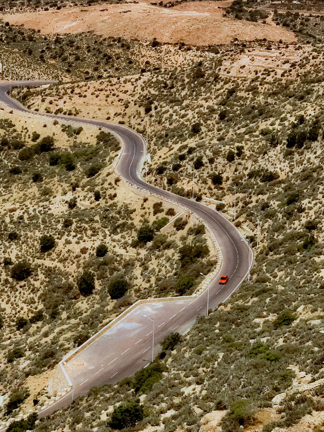
Ascend North Africa's highest peak on the Jebel Toubkal Ascent, a demanding 41.8km route through Morocco's High Atlas Mountains. This 2-3 day trek from Imlil offers rugged alpine terrain, dramatic panoramas, and a glimpse into Berber culture. Expect challenging ascents and scree slopes as you traverse this pristine wilderness to the summit.
Distance: 41.8 km
Elevation Gain: 2574 m
Difficulty: Challenging
Duration: 2-3 days
The Jebel Toubkal Ascent is a challenging yet immensely rewarding mountain trek, culminating in the summit of North Africa's highest peak. Located in the High Atlas Mountains of Morocco, this route offers a dramatic introduction to high-altitude trekking, blending rugged mountain scenery with Berber culture. The ascent typically begins from the village of Imlil, a picturesque mountain settlement that serves as the gateway to the Toubkal massif. The trail winds through traditional Berber villages, past terraced fields, and into stark, arid landscapes that gradually give way to scree slopes and rocky ascents as you gain elevation. The journey is often undertaken over two to three days, allowing for acclimatisation and a more enjoyable experience of the mountain's grandeur. While the climb is physically demanding, particularly the final push to the summit, it is accessible to reasonably fit hikers with proper preparation and guidance. The panoramic views from the summit, stretching across the Atlas Mountains and into the Sahara Desert on a clear day, are an unforgettable reward for the effort expended.
The Jebel Toubkal Ascent is a classic mountain expedition that offers a taste of high-altitude trekking without requiring extreme technical skills. The route is well-trodden, particularly during the peak seasons, and is supported by a network of mountain refuges and local guides. The journey typically starts in Imlil, a vibrant Berber village nestled in the Ait Mizane Valley, at an elevation of around 1,740 metres. From Imlil, the trail ascends through a series of valleys and passes, offering glimpses into the traditional way of life in the High Atlas. The landscape is characterised by its dramatic contrasts: fertile valleys dotted with walnut trees and small villages give way to barren, rocky slopes and vast scree fields as the altitude increases.
The ascent is usually broken down into stages. Day one often involves trekking from Imlil to a refuge or gite located at a higher altitude, such as the Toubkal Refuge (Neltner Hut) or the CAF (Club Alpin Français) Refuge, typically around 3,207 metres. This day is crucial for acclimatisation, allowing the body to adjust to the thinning air. The trek itself is not overly technical, but the steady, sustained climb can be taxing. The scenery on this day is often spectacular, with views of the surrounding peaks and deep valleys.
The summit day is the most demanding. Starting in the pre-dawn darkness, hikers make their way up steep scree and boulder-strewn slopes towards the summit plateau. The final approach to the 4,167-metre peak is a scramble over loose rocks, but the path is generally clear. The reward for reaching the summit is immense: a breathtaking 360-degree panorama that can, on a clear day, extend to the Sahara Desert and the Atlantic Ocean. The descent follows the same route, often returning to Imlil on the third day, or to a lower-lying gite for a final night before returning to Marrakech.
The cultural aspect of the Toubkal trek is as significant as the physical challenge. Interacting with local Berber guides and muleteers, experiencing their hospitality, and observing their traditional way of life adds a rich dimension to the journey. The mountain is considered sacred by the local population, and the summit is a place of pilgrimage for many.
The High Atlas Mountains have been inhabited for millennia, with Berber communities establishing a unique way of life deeply connected to the land. These mountain dwellers, known as Amazigh, have a rich history of agriculture, pastoralism, and trade, utilising the valleys and passes of the Atlas range for centuries. The routes that now form the basis of the Toubkal trek were historically used by local people for seasonal migration, trade, and as pilgrimage routes.
Jebel Toubkal itself, known locally as "Adrar n'Dern" (Mountain of Mountains), has long held spiritual significance. Its imposing presence and the challenging nature of its ascent have made it a place of reverence. While not a site of major historical events in the same vein as ancient cities, its importance lies in its enduring role as a natural landmark and a spiritual destination for the indigenous Berber people.
The formalisation of the Toubkal ascent as a trekking destination for international visitors began in the mid-20th century. As mountaineering and adventure tourism grew, the High Atlas, with Toubkal as its crown jewel, became an increasingly popular destination. The establishment of mountain refuges, such as the CAF Refuge and the Toubkal Refuge (Neltner Hut), facilitated easier access and overnight stays, making the summit more attainable for a wider range of trekkers. These refuges were often built and maintained by mountaineering clubs and local authorities, aiming to support tourism while respecting the mountain's environment and cultural heritage.
Today, the trek is a significant source of income for the local Berber communities, with many villagers working as guides, muleteers, and in the hospitality sector. The cultural exchange between trekkers and locals is a vital part of the experience, offering insights into a way of life that has remained remarkably consistent for generations, despite the increasing influx of visitors.
The Jebel Toubkal Ascent is best undertaken during specific periods to ensure favourable weather conditions and a safer trekking experience. The mountain's altitude means that weather can change rapidly and dramatically, regardless of the season.
Spring (April to May): This is an excellent time to climb Toubkal. The snow has largely melted from the main trekking routes, although patches may remain at higher elevations, particularly on north-facing slopes. The weather is generally mild, with sunny days and cool nights. Wildflowers begin to bloom in the valleys, adding colour to the landscape. However, there is still a possibility of late snowfalls or storms, especially in early April. Temperatures can range from around 10-20°C in the valleys during the day to near freezing at higher altitudes at night.
Summer (June to August): While technically possible, summer is generally not the preferred season for climbing Toubkal. The days can be very hot, especially in the lower valleys, making the ascent more strenuous. The higher altitudes can still be pleasant, but the heat in Imlil and the lower sections can be intense. Water sources may also be scarcer during the driest months. However, if you are prepared for the heat, summer offers the most stable weather with the lowest chance of snow or ice.
Autumn (September to October): This is another prime season for the Toubkal ascent. The intense heat of summer has subsided, and the weather is typically stable and clear. The autumn colours in the valleys can be beautiful, and the air is crisp and fresh. Temperatures are similar to spring, with pleasant days and cold nights at altitude. This period offers excellent visibility for summit views.
Winter (November to March): Climbing Toubkal in winter requires significant mountaineering experience, specialised equipment (ice axe, crampons, warm clothing), and knowledge of avalanche safety. The mountain is often covered in deep snow, and conditions can be extremely harsh, with freezing temperatures, strong winds, and blizzards. While it offers a challenging adventure for experienced winter climbers, it is not recommended for casual trekkers or those new to high-altitude environments. The refuges are usually open but may have limited services.
Weather Considerations: Regardless of the season, always be prepared for rapid changes. High winds, sudden storms, and significant temperature drops can occur at any time. The summit plateau is exposed and can be very cold and windy, even on a sunny day.
Day 1: Imlil (1,740 m) to Toubkal Refuge (3,207 m)
Day 2: Toubkal Refuge (3,207 m) to Jebel Toubkal Summit (4,167 m) and return to Imlil (1,740 m)
Day 1: Imlil (1,740 m) to Tacheddirt (2,300 m) or Ouanesk (2,000 m)
Day 2: Tacheddirt/Ouanesk to Toubkal Refuge (3,207 m) via Tizi n'Tamatert (2,279 m)
Day 3: Toubkal Refuge (3,207 m) to Jebel Toubkal Summit (4,167 m) and return to Imlil (1,740 m)
Important Notes:
The Jebel Toubkal Ascent is a serious mountain trek that requires careful planning. The closest major city is Marrakech, which serves as the primary gateway for international travellers. From Marrakech, you will need to arrange transport to Imlil, the starting point of the trek. This can be done via grand taxi (shared taxis) or a pre-booked private transfer. The journey takes approximately 1.5 to 2 hours and involves winding mountain roads. Parking is available in Imlil, usually for a small fee.
It is advisable to spend at least one night in Marrakech before heading to Imlil to adjust to the climate and prepare your gear. In Imlil, you can finalise arrangements with your guide and muleteers if you have booked them in advance. Registration at the Bureau des Guides in Imlil is often required, especially if you are hiring a local guide.
Fitness is paramount. While the Toubkal trek is not technically difficult, the sustained ascents and the altitude can be challenging. Aim to be in good cardiovascular condition, with experience in hiking and carrying a day pack. Training should include regular aerobic exercise and hikes with elevation gain.
Accommodation on the Jebel Toubkal trek typically consists of mountain refuges and traditional Berber gites.
Toubkal Refuge (Neltner Hut):
CAF (Club Alpin Français) Refuge:
Berber Gites:
This is a multi-day hike requiring overnight accommodation in mountain refuges or gites.
For the standard Jebel Toubkal ascent, formal permits are generally not required for independent trekkers or those accompanied by a licensed guide. However, it is mandatory to register your trek and hire a licensed mountain guide if you are not part of an organised tour. This is for safety reasons and to support the local economy.
Registration and Guides:
Refuge Bookings: While not a permit, booking accommodation at the Toubkal Refuge or CAF Refuge in advance is crucial, especially during the peak trekking seasons (April-May and September-October). These bookings can often be made through your guide or tour operator.
National Park Fees: There are no specific national park entrance fees for trekking in the Toubkal region for day hikers or those staying in refuges. However, the costs associated with hiring guides and mules, and paying for refuge accommodation, contribute to the local economy and park management indirectly.
Winter Ascents: For winter ascents requiring technical equipment like ice axes and crampons, additional considerations may apply, and it is imperative to have a highly experienced guide who is proficient in winter mountaineering.

Detailed route notes, maps, logistics & tips for the Jebel Toubkal Ascent (PDF).

Precisely traced GPX for the Jebel Toubkal Ascent, ready for your GPS or favourite mapping app.
Beyond the Jebel Toubkal ascent, the High Atlas Mountains offer a wealth of activities and experiences:
Altitude Sickness (Acute Mountain Sickness - AMS): This is the primary concern on the Toubkal ascent. Symptoms include headache, nausea, dizziness, and fatigue. The best prevention is gradual ascent and acclimatisation. The 3-day itinerary is strongly recommended to allow your body to adjust. If symptoms worsen, descend immediately.
Weather: Mountain weather is unpredictable. Be prepared for rapid changes, including strong winds, rain, snow, and significant temperature drops, even in summer. Always check the forecast before you go and be ready to turn back if conditions deteriorate.
Guides and Registration: Hiring a licensed local guide is essential for safety and navigation. Registering your trek at the Bureau des Guides in Imlil ensures that authorities are aware of your plans.
Terrain: The trails can be steep, rocky, and covered in scree, especially on the final ascent to the summit. Sturdy hiking boots and trekking poles are highly recommended.
Water: Carry sufficient water and use a water filter or purification tablets. Dehydration can exacerbate altitude sickness.
Communication: Mobile phone signal is unreliable in the mountains. Consider carrying a satellite messenger or Personal Locator Beacon (PLB) for emergencies.
Health: Ensure you are up-to-date with vaccinations and carry a personal first-aid kit. Consult your doctor about altitude sickness medication (e.g., Diamox) if you are concerned.
Respect Local Customs: Dress modestly when passing through villages, and be respectful of local traditions and religious sites.
Sidi Chamharouch: A significant pilgrimage site for Muslims, marked by a white-domed marabout perched on a rocky outcrop. It is a sacred place, and visitors are expected to show respect. The shrine itself is not accessible to non-Muslims, but the surrounding area offers a unique cultural insight and a good resting point on the ascent to the refuge.
Aroumd (Aremd) Village: This traditional Berber village, located at 1,945 metres, is a picturesque stop on the way from Imlil. It is known for its distinctive terraced fields, stone houses, and the ancient mosque. Exploring Aroumd provides a glimpse into the daily life of the mountain communities.
Tizi n'Tamatert Pass: If taking the 3-day itinerary via Tacheddirt, you will cross this pass at 2,279 metres. It offers expansive views of the surrounding valleys and peaks, and is a good spot for a break and photos.
Summit Views: The primary "point of interest" is, of course, the summit of Jebel Toubkal itself. On a clear day, the panoramic views are breathtaking, stretching across the High Atlas range, the plains of Marrakech, and potentially as far as the Sahara Desert and the Atlantic Ocean. The feeling of accomplishment upon reaching the highest point in North Africa is immense.
The Toubkal Massif: The entire area surrounding Toubkal is a region of dramatic geological formations, deep valleys, and rugged peaks, offering a visually stunning landscape throughout the trek.
The Jebel Toubkal region is a fragile mountain ecosystem that relies on responsible tourism to maintain its natural beauty and cultural integrity. Adhering to Leave No Trace principles is crucial for preserving this environment for future generations.
Plan Ahead and Prepare: Understand the conditions, hire licensed guides, and pack appropriately. This minimises risks and environmental impact.
Travel and Camp on Durable Surfaces: Stick to established trails and designated camping areas (if applicable, though most trekkers use refuges). Avoid walking on fragile vegetation, especially in the valleys and around water sources.
Dispose of Waste Properly: Pack out everything you pack in, including all food scraps, wrappers, and toilet paper. Use the designated toilets at refuges. If wild camping, dig catholes at least 60 metres away from water sources, trails, and campsites.
Leave What You Find: Do not take rocks, plants, or cultural artefacts. Respect the natural and cultural heritage of the area.
Minimise Campfire Impacts: Campfires are generally not permitted or advisable in the High Atlas due to the risk of wildfires and the scarcity of firewood. Use a stove for cooking.
Respect Wildlife: Observe wildlife from a distance and do not feed any animals. This includes stray dogs in villages and any wild animals you might encounter.
Be Considerate of Other Visitors: Keep noise levels down, especially in refuges and villages. Yield to ascending hikers on narrow trails. Respect local customs and traditions.
By following these principles, you contribute to the sustainability of trekking in the High Atlas and ensure a positive experience for both yourself and the local communities.