Jebel Sahro Trek - The Volcanic Heart of the Anti-Atlas
The Jebel Sahro Trek is Morocco’s most compelling desert mountain adventure—a 70-kilometre journey through a surreal landscape of volcanic plugs, deep gorges, and high-altitude plateaus. Situated between the snow-capped High Atlas Mountains and the vast sands of the Sahara, the Jebel Sahro (also spelled Djebel Saghro) offers a stark, lunar beauty that feels entirely removed from the modern world. This is the ancestral home of the Ait Atta tribe, a resilient nomadic people who have navigated these rugged basalt ridges for centuries. Unlike the lush valleys of the north, the Sahro is a land of dramatic geological upheaval, where ancient magma chambers have been weathered into towering monoliths and hidden oases provide life-sustaining water to isolated settlements. Travelling through this region is not merely a physical challenge; it is an immersion into a landscape defined by silence, scale, and the enduring traditions of the Berber nomads.
- Distance: 70.0 km (variable depending on route)
- Duration: 5–7 days
- Season: October to April (avoiding the extreme heat of summer)
- Accommodation: Gites d’étape, nomadic campsites, and wild camping
- Highest point: Tizi n’Ouarg or Kouaouch Summit (2,592 m)
- Difficulty: Moderate (requires good stamina and comfort with rocky terrain)
- Direction: Typically North to South (Tagdilte to N’Kob)
Overview
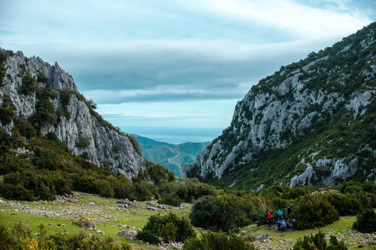
The Jebel Sahro is often described as Morocco’s "Wild West." This volcanic massif, part of the Anti-Atlas range, was formed millions of years ago through intense tectonic activity and subsequent erosion. The result is a landscape that defies easy description: vast mesas that resemble the American Southwest, jagged black peaks that look like charred ruins, and deep, narrow canyons where oleander and almond trees thrive against the odds. The trek is a masterclass in geological diversity. One day you may be crossing a high, windswept plateau where the only signs of life are the low-slung black wool tents of the Ait Atta; the next, you are descending into a lush canyon where a hidden spring creates a vibrant green ribbon of date palms and barley fields.
The physical rhythm of the Jebel Sahro trek is demanding but deeply rewarding. The terrain is predominantly rocky, with paths consisting of loose scree, ancient mule tracks, and dry riverbeds (wadis). While the elevation gains are not as extreme as those found in the High Atlas, the constant "up and down" nature of the ridges—combined with the dry, desert air—requires a steady pace and careful hydration. The trek typically begins in the village of Tagdilte on the northern slopes and concludes in the palm groves of N’Kob to the south. This trajectory allows hikers to witness the transition from the high mountain pastures to the pre-Saharan architecture of the southern valleys, where the famous "kasbahs" (fortified houses) dominate the skyline.
What sets the Jebel Sahro apart from other Moroccan treks is the profound sense of solitude. While Mount Toubkal attracts thousands of climbers, the Sahro remains relatively quiet. You are more likely to encounter a shepherd tending a flock of goats or a nomadic family moving their camp than a crowd of tourists. This isolation preserves the authenticity of the experience. The hospitality of the local people is legendary; it is common to be invited for mint tea in a nomad tent, providing a rare window into a way of life that has remained largely unchanged for generations. In the Sahro, the landscape and the culture are inseparable, creating a trekking experience that is as much about human connection as it is about natural beauty.
Geologically, the massif is a treasure trove. The "dykes" (vertical walls of igneous rock) and "plugs" (the hardened remains of volcanic vents) create a skyline of impossible shapes. The most famous of these are the twin towers of Bab n’Ali, which stand like sentinels over the southern approaches. For those with an interest in photography, the play of light on the dark basalt and red sandstone at sunrise and sunset is nothing short of spectacular. The Jebel Sahro is not just a walk; it is a journey through deep time and living history.
History and Cultural Context
The history of the Jebel Sahro is inextricably linked to the Ait Atta, one of Morocco’s most powerful and historic Berber (Amazigh) tribal confederations. For centuries, the Ait Atta controlled the vast territories between the Draa Valley and the Tafilalt, managing a complex system of transhumance. Every year, they moved their livestock from the scorching desert plains in the summer to the high mountain pastures of the Atlas, and back again in the winter. The Jebel Sahro served as their winter stronghold, a rugged sanctuary where their herds could find grazing land even when the surrounding plains were parched. This nomadic lifestyle continues today, though many families have now settled in villages like N’Kob and Tagdilte.
The Jebel Sahro also holds a significant place in modern Moroccan history as the site of one of the last great stands against French colonial rule. In 1933, the Ait Atta, led by the legendary chieftain Assou oubasslam, retreated to the heights of Jebel Bougafer to resist the advancing French military. Despite being heavily outnumbered and facing aerial bombardment, the tribesmen and their families held out for weeks in the rocky crags, using their intimate knowledge of the terrain to repel ground assaults. The Battle of Bougafer remains a symbol of Moroccan resistance and tribal pride. Hikers can still see the remains of stone fortifications and spent shell casings on the slopes of Bougafer, a sobering reminder of the conflict that took place in this now-peaceful landscape.
Culturally, the region is a bastion of Amazigh traditions. The language spoken is Tashelhit, and the social structure remains rooted in tribal lineages. The architecture of the region is also distinct; the southern edge of the Sahro is famous for its "Tighremts"—multi-storey fortified granaries and dwellings built from pisé (rammed earth). These structures, with their ornate brickwork and tapering towers, were designed for both defence and communal storage. Walking through the Sahro is an opportunity to witness the resilience of a culture that has adapted to one of the harshest environments on Earth. The respect for the land, the importance of water rights, and the code of hospitality are all deeply ingrained in the daily life of the people you will meet along the trail.
Want more background? Read extended notes on history and cultural context → Learn more
Seasonal Highlights and Weather Reality
Timing is everything when planning a trek in the Jebel Sahro. Because of its proximity to the Sahara, the region experiences extreme temperature fluctuations. The trekking season is strictly limited to the cooler months, as the summer heat can be life-threatening for those exerting themselves on the trail.
Autumn (October to November): This is arguably the best time to visit. The intense heat of summer has faded, but the days remain warm and the skies are typically crystal clear. Daytime temperatures usually hover between 20°C and 25°C, while nights begin to get chilly, often dropping to 5°C or 10°C. The landscape is at its driest, but the visibility for photography is exceptional.
Winter (December to February): Winter offers a different kind of beauty. The air is crisp and the light is soft. However, walkers must be prepared for cold temperatures. While daytime highs can reach 15°C to 18°C in the sun, night-time temperatures frequently drop below freezing, especially at higher camps like Almou n’Ouarg. Snow is possible on the highest peaks, such as Kouaouch, though it rarely lingers long on the trails. This is the quietest time on the track, offering maximum solitude.
Spring (March to April): Spring brings a burst of life to the Sahro. This is the time of the almond blossoms in the lower valleys, and the occasional rain shower can trigger a brief but beautiful flowering of desert plants. The nomadic families are often on the move during this period, making for fascinating cultural encounters. Temperatures begin to rise, with April seeing daytime highs of 28°C. By late May, the heat becomes too intense for comfortable trekking.
Summer (May to September): Trekking is not recommended during these months. Temperatures in the canyons can exceed 40°C, and water sources become extremely scarce. Most local guides and muleteers move to the High Atlas during this time to escape the heat.
Recommended Itinerary
6-Day Jebel Sahro Traverse
Day 1: Tagdilte to Almou n’Ouarg
- Distance: 12 km
- Elevation gain: 800 m
- Time: 5–6 hours
- Start in the village of Tagdilte (1,650 m) on the northern edge of the massif
- Gradual ascent through rocky foothills and ancient volcanic debris
- Climb toward the Tizi n’Ouarg pass, offering the first expansive views of the High Atlas to the north
- Camp or stay in a basic gite at Almou n’Ouarg (2,250 m), a high-altitude pasture used by nomads
- The air is noticeably thinner and cooler here; evening temperatures drop quickly
Day 2: Almou n’Ouarg to Igli via Kouaouch
- Distance: 14 km
- Elevation gain: 400 m (to summit), 700 m descent
- Time: 6–7 hours
- Ascent to the summit of Jebel Kouaouch (2,592 m), the highest point of the trek
- 360-degree views encompassing the M’Goun massif and the distant sands of the Sahara
- Descent through a surreal landscape of weathered rock "mushrooms" and sandstone towers
- Arrive at the small nomadic settlement of Igli (1,700 m), nestled among spectacular rock formations
- Igli is one of the most photogenic spots on the trail, especially at sunset
Day 3: Igli to Bab n’Ali
- Distance: 13 km
- Elevation loss: 400 m
- Time: 5–6 hours
- Follow the Afourer River through a series of narrow, winding gorges
- Pass through small oases where local families tend to tiny plots of vegetables
- The landscape opens up to reveal the massive basalt towers of Bab n’Ali (Ali’s Gate)
- Camp near the base of these iconic twin monoliths
- Explore the nearby waterfalls (seasonal) and the dramatic rock architecture
Day 4: Bab n’Ali to Assaka n’Ait Ouzzine
- Distance: 12 km
- Elevation: Various ups and downs through ridges
- Time: 5 hours
- Cross the plateau of Tadaout n’Tabour, characterised by its flat-topped mesas
- Descend into the valley of the Ait Ouzzine tribe
- Observe the transition from volcanic rock to the red earth architecture of the southern slopes
- Stay in a traditional village gite in Assaka, experiencing local Berber hospitality
- Opportunity to see traditional irrigation systems (khettaras) in action
Day 5: Assaka to Tifdassine
- Distance: 10 km
- Elevation gain: 300 m
- Time: 4–5 hours
- Walk through a series of almond and fig groves
- Cross the Tizi n’Tifdassine pass, providing views back toward the heart of the Sahro
- Descend into a wide valley dotted with oleander bushes
- Camp near the village of Tifdassine, a quiet settlement far from the main tourist routes
- Final night under the spectacular desert stars
Day 6: Tifdassine to N’Kob
- Distance: 9 km
- Elevation loss: 400 m
- Time: 3–4 hours
- Easy descent toward the palm groves of N’Kob
- The trail joins a wider track used by local vehicles and mules
- Enter N’Kob, famous for its 45 historic kasbahs
- Celebrate the completion of the trek with a traditional tagine in a restored kasbah
- Afternoon transfer back to Ouarzazate or onward to the Draa Valley
Important Notes:
- The itinerary is flexible; many groups choose to spend an extra day at Igli or Bab n’Ali for exploration
- Mules are used to carry heavy gear, allowing hikers to walk with only a daypack
- Water sources are limited; always carry at least 3 litres of water per day
- The sun is intense even in winter; high-factor sunscreen and a wide-brimmed hat are essential
- Respect local customs by asking permission before taking photos of people
Planning and Bookings
Book Your Trip
Everything you need to plan your journey
Accommodation
Find places to stay near Ouarzazate
Flights
Search flights to Ouarzazate
Essential Preparation
Planning a trek in the Jebel Sahro requires more logistical coordination than a standard European hike. The most important decision is whether to go independently or with an organised group. While experienced navigators can do it alone, hiring a local guide and muleteer is highly recommended. Not only does this support the local economy, but it also ensures safety in a region where trails are often faint and water sources are hidden. Most treks are organised out of Ouarzazate, which is the primary gateway to the region. You should spend at least one night in Ouarzazate to meet your guide, check your gear, and purchase supplies.
Physical fitness is important. While the Sahro is not an alpine climb, the terrain is consistently rocky and uneven. You should be comfortable walking 6–7 hours a day for several consecutive days. Training on hills or using a stair machine will help prepare your legs for the constant elevation changes. Additionally, ensure you have a basic understanding of Moroccan cultural etiquette, particularly regarding dress (modest clothing is preferred) and social interactions in remote villages.
Trail Accommodation
Accommodation in the Jebel Sahro is a mix of wild camping and "Gites d’étape" (village guesthouses). There are no luxury hotels on the trail itself, so a spirit of adventure is required.
Gites d’étape: These are simple, family-run guesthouses in villages like Tagdilte, Assaka, and N’Kob. They typically offer communal sleeping areas (carpets and thin mattresses on the floor), shared squat toilets, and a basic shower (sometimes with hot water, but don't count on it). They provide an excellent opportunity to eat home-cooked Moroccan food and interact with local families.
Camping: Most trekkers spend several nights in tents. If you are with a guided group, the muleteers will set up a mess tent for meals and individual sleeping tents. Wild camping is permitted throughout the massif, but it is best to camp near established nomadic sites or water sources. You will need a high-quality 3-season sleeping bag, as temperatures at night can be very cold.
Nomad Tents: Occasionally, hikers may be invited to stay near or within a nomadic encampment. These are the traditional black tents made from goat and camel hair. While basic, they offer incredible protection against the wind and an unforgettable cultural experience.
Required Gear
- Trekking boots: Sturdy, well-broken-in boots with good ankle support are non-negotiable. The terrain is very rocky and "sharp."
- Sleeping bag: A 3-season bag with a comfort rating of 0°C to -5°C is essential for winter and shoulder season treks.
- Trekking poles: Highly recommended to save your knees on the steep, loose descents and to provide stability on rocky paths.
- Layers: A moisture-wicking base layer, a fleece mid-layer, and a lightweight down jacket for cold evenings.
- Waterproof shell: While rain is rare, the wind can be biting on the ridges; a good windproof/waterproof jacket is vital.
- Head torch: Essential for navigating camps and gites at night, as electricity is often non-existent or unreliable.
- Daypack: A 25–35 litre pack for your water, snacks, camera, and extra layers.
What to Bring
- Water treatment: Purification tablets or a filter (e.g., Sawyer Squeeze) are necessary for treating water from wells or springs.
- Sun protection: High-SPF sunscreen, lip balm with SPF, and a wide-brimmed hat. The desert sun is relentless.
- First aid kit: Include blister pads (Compeed), rehydration salts (ORS), ibuprofen, and any personal medications.
- Snacks: High-energy bars, nuts, and dried fruit. While meals are provided on guided treks, extra calories are always welcome.
- Toiletries: Biodegradable soap, wet wipes (for "dry showers"), and a small towel.
- Power bank: To keep your phone and camera charged, as there are no charging points on the trail.
- Cash: Small denominations of Moroccan Dirhams (MAD) for tipping guides/muleteers and buying small items in villages.
Permits
Currently, there are no formal permits required by the Moroccan government to hike in the Jebel Sahro. Unlike some national parks in other countries, the massif is open land. However, there are several informal "permits" and registrations that are part of a responsible trek.
Local Registration: If you are hiring a guide, they will typically handle the necessary notifications to the local authorities (Gendarmerie) in Ouarzazate or the trailhead villages. This is a safety measure so that officials know who is in the mountains in case of an emergency. If you are trekking independently, it is wise to leave your itinerary with your hotel in Ouarzazate or the local authorities in Tagdilte.
Guide Certification: Ensure your guide is officially licensed by the Moroccan Ministry of Tourism. Licensed guides carry a professional ID card and have undergone rigorous training at the mountain guide school in Tabant. Using a licensed guide ensures a higher standard of safety and environmental knowledge.
Costs: While there is no permit fee, you should budget for the following daily costs (approximate):
- Licensed Guide: 400–600 MAD per day
- Mule and Muleteer: 150–200 MAD per day
- Gite d’étape (half board): 150–250 MAD per night
- Food supplies: 100–150 MAD per day
Insurance: It is mandatory to have travel insurance that specifically covers "trekking" or "hiking" up to 3,000 metres. Ensure your policy includes emergency helicopter evacuation, although such services are extremely limited in Morocco and usually coordinated through the military.
Other Activities in the Area
The region surrounding the Jebel Sahro is rich in history and natural beauty. Consider these additions to your itinerary:
- Ouarzazate Film Studios: Known as the "Hollywood of Africa," Ouarzazate is home to Atlas Studios. You can tour the sets of famous films like Gladiator, Kingdom of Heaven, and Game of Thrones.
- Ait Benhaddou: A UNESCO World Heritage site, this ancient ksar (fortified village) is one of the most iconic examples of Moroccan earthen architecture. It is located about 30 kilometres from Ouarzazate.
- Draa Valley: South of N’Kob lies the Draa Valley, a massive palm grove stretching toward the Sahara. It is home to hundreds of kasbahs and the famous pottery village of Tamegroute.
- Skoura Oasis: A lush "Palmeraie" near Ouarzazate, perfect for a relaxing day of walking through gardens and visiting the beautifully restored Kasbah Amridil.
- Dades Gorge and Todra Gorge: Located to the north of the Sahro, these spectacular limestone canyons offer world-class rock climbing and shorter day hikes.
Safety and Conditions
Navigation: The Jebel Sahro is a labyrinth of mule tracks. While some are well-defined, others disappear into rocky plateaus or dry riverbeds. GPS is useful, but a local guide’s knowledge of the terrain and water sources is invaluable. Do not rely solely on mobile phone apps, as signal is non-existent in the heart of the massif.
Hydration and Heat: Dehydration is the most common safety issue. The air is incredibly dry, and you will lose moisture through respiration and perspiration without even realising it. Aim to drink at least 3–4 litres of water a day. Heat exhaustion can occur even in the shoulder seasons; if you feel dizzy or nauseous, stop in the shade immediately and hydrate.
Flash Floods: While the Sahro is an arid region, heavy rain in the High Atlas can cause sudden flash floods in the canyons (wadis) of the Sahro. If the sky looks dark upstream or if it begins to rain, move to higher ground immediately. Never camp in the bottom of a dry riverbed.
Wildlife: Scorpions and vipers exist in the Sahro but are rarely seen during the cooler trekking months. As a precaution, always shake out your boots in the morning and avoid sticking your hands into dark rock crevices. The most common "dangerous" animals are the large, protective dogs kept by nomadic shepherds; always give them a wide berth and wait for the shepherd to signal it is safe to pass.
Emergency Contacts: Ensure you have the contact details for the Gendarmerie Royale in Ouarzazate and N’Kob. Carry a satellite communication device (like a Garmin inReach) if you are travelling without a guide.
Side Trips and Points of Interest
Bab n’Ali: These twin basalt towers are the most famous landmark in the Jebel Sahro. Legend says they are named after a local hero, Ali, who used the towers as a gateway to defend the valley. The area around the towers is a maze of smaller rock formations and hidden caves. A short scramble to the base of the towers provides a perspective on their immense scale.
Jebel Bougafer: For history buffs, a detour to the site of the 1933 battle is a must. The slopes are still littered with the remains of the conflict. It is a place of great solemnity and offers some of the most rugged terrain in the entire massif. A local guide can point out the specific positions held by the Ait Atta resistance.
The Valley of Birds: Near the village of Igli, there is a hidden valley known for its birdlife. Depending on the season, you may spot Bonelli’s eagles, Lanner falcons, and various species of wheatears. The silence of the Sahro makes birdwatching a particularly rewarding experience.
Nomadic Encampments: While not a "site" in the traditional sense, visiting a nomadic camp is a highlight for many. If invited, remember to remove your shoes before entering the tent and accept the first three glasses of tea as a gesture of respect. Small gifts like school supplies for children or bags of flour/sugar are often appreciated, but avoid giving money directly to children.
Leave No Trace
The Jebel Sahro is a fragile desert ecosystem where decomposition happens very slowly. With increasing numbers of trekkers, it is vital to follow Leave No Trace principles to preserve this landscape for the Ait Atta and future visitors.
Waste Management: Pack out everything you pack in. This includes fruit peels, nut shells, and cigarette butts. In the dry desert air, an orange peel can take years to decompose. For human waste, use the toilets in gites whenever possible. If you must go on the trail, dig a "cathole" at least 15–20 centimetres deep and at least 60 metres away from any water source or dry riverbed. Pack out your toilet paper in a sealed plastic bag.
Water Conservation: Water is the most precious resource in the Sahro. Never wash yourself or your clothes directly in a spring or well. Collect water in a container and move at least 30 metres away to wash. Use biodegradable soap sparingly.
Respecting Heritage: Do not remove any fossils, stones, or historical artefacts (like shell casings from Bougafer). Leave them where they are for others to discover. Similarly, do not deface rocks with graffiti or "stack" stones into cairns where they aren't needed for navigation.
Fire: Wood is extremely scarce in the Sahro and is needed by local nomads for cooking. Do not build campfires. Use a lightweight gas or multi-fuel stove for all your cooking needs.