Janapar Trail - The Footprint of the Caucasus
The Janapar Trail is a remarkable long-distance hiking route that traverses the rugged and soul-stirring landscapes of the Lesser Caucasus mountains. Stretching approximately 289 kilometres, this multi-day journey offers an unparalleled immersion into a region where ancient history, vibrant village culture, and raw natural beauty converge. The name "Janapar" translates simply to "path" or "journey" in Armenian, a fitting title for a trail that serves as a literal and metaphorical bridge between remote mountain communities and centuries-old architectural wonders. Unlike many modern trails that bypass human settlements, the Janapar Trail is intentionally designed to lead walkers through the heart of rural life, connecting a series of high-altitude villages, medieval monasteries, and dramatic limestone canyons.
The route is marked by a distinctive symbol—a blue and white footprint—which guides hikers through a diverse tapestry of ecosystems. From the dense, humid forests of the north to the arid, sun-drenched ridges of the south, the trail demands physical resilience and an adventurous spirit. With a total elevation gain of approximately 11,000 metres, it is a challenging undertaking that rewards the persistent traveller with views of jagged peaks, hidden waterfalls, and some of the most significant cultural monuments in the Caucasus region. This is not merely a walk; it is an odyssey through a landscape that has remained largely unchanged for generations, offering a rare glimpse into a world where hospitality is a sacred duty and the mountains are a way of life.
- Distance: 289.0 km total
- Duration: 12–14 days
- Difficulty: Moderate to Challenging (due to elevation and navigation)
- Total Elevation Gain: 11,000 m
- Highest Point: Approximately 2,300 m
- Best Time: June to September
- Trailhead: Vank (Northern Section)
- End Point: Hadrut (Southern Section)
Overview
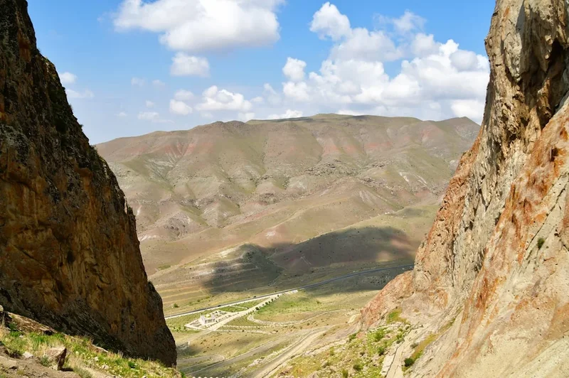
The Janapar Trail is a masterclass in geographical diversity. The northern sections are defined by the lush, emerald-green canopy of the Mrav Mountains, where ancient oak and hornbeam forests provide shade for hikers as they navigate steep ridgelines. As the trail progresses southward, the landscape shifts dramatically into the limestone karst topography of the Hunot Canyon and the rolling, vineyard-covered hills of the southern districts. This transition is one of the trail's most captivating features, ensuring that no two days of walking feel the same. The route is divided into manageable daily stages, typically ranging from 15 to 25 kilometres, each ending in a village where the tradition of the "homestay" provides the primary form of accommodation.
Physically, the trail is classified as moderate, but this label can be deceptive. While the paths are generally well-trodden, the sheer volume of vertical gain and loss—averaging nearly 1,000 metres of ascent per day—requires a high level of cardiovascular fitness and sturdy knees. The terrain varies from wide dirt tracks used by local shepherds to narrow, overgrown single-track paths that cling to the sides of steep valleys. Navigation can be a challenge; while the blue footprint markers are present, they can be sparse in certain sections, making a GPS device or a reliable offline mapping application an absolute necessity for any independent hiker.
What truly sets the Janapar Trail apart is its cultural depth. The trail was conceived not just as a recreational asset, but as a means of sustainable economic development for remote mountain villages. By walking the Janapar, you are participating in a living history. You will encounter shepherds tending their flocks of fat-tailed sheep, women gathering wild herbs for "jingalov hats" (a traditional herb-filled flatbread), and village elders who are often eager to share a glass of mulberry vodka and a story. The trail passes through the shadows of some of the world's oldest Christian architecture, including the monasteries of Dadivank and Gtichavank, which stand as silent sentinels over the valleys they have occupied for over a millennium.
History and Cultural Context
The Janapar Trail is a relatively modern creation that follows ancient footsteps. It was officially established in 2002 by Raffi Kojian, an Armenian-American writer and explorer who recognised the potential for a world-class trekking route that could connect the region's disparate historical sites. Kojian's vision was to create a "Caucasus version" of the Appalachian Trail or the Camino de Santiago, focusing on the unique hospitality and heritage of the Armenian highlands. Before the trail was formalised, many of these paths were used exclusively by local villagers, shepherds, and monks moving between mountain outposts.
The cultural context of the trail is deeply intertwined with the history of the Armenian people in the Caucasus. The region has been a crossroads of empires for millennia, from the Urartians and Persians to the Romans, Byzantines, and Mongols. This complex history is etched into the landscape. Hikers will encounter "khachkars"—intricately carved stone crosses—scattered across the mountainsides, often marking ancient graves or commemorating significant events. These stones are unique to Armenian culture and are recognised by UNESCO as Intangible Cultural Heritage. The monasteries along the route, such as Dadivank (founded in the 1st century and rebuilt in the 12th), are masterpieces of medieval architecture, featuring delicate stone carvings and frescoes that have survived centuries of conflict and neglect.
The trail also reflects the resilience of the local population. The villages you pass through have weathered significant geopolitical shifts, yet the core values of the mountain people remain steadfast. Hospitality, or "hyurasirutyun," is the cornerstone of the Janapar experience. It is common for hikers to be invited into homes for coffee or a full meal, even by those who have very little to give. Understanding this cultural backdrop—the pride in the land, the deep religious roots, and the enduring spirit of the community—is essential for anyone wishing to truly experience the Janapar Trail.
Want more background? Read extended notes on history and cultural context → Learn more
Seasonal Highlights and Weather Reality
The window for hiking the Janapar Trail is relatively narrow due to the high-altitude nature of the Caucasus mountains. The primary season runs from June to September, when the weather is generally warm and dry, and the high passes are free of snow.
Spring (April to May): While the lower valleys begin to bloom with wildflowers and the air is crisp, spring is a difficult time for the full trail. Snow often lingers on the higher ridges until late May, and the spring melt can turn mountain streams into impassable torrents. However, the lower sections near Shushi and Hadrut can be beautiful for day hikes during this period.
Summer (June to August): This is the peak season. June is particularly spectacular, as the alpine meadows are carpeted in vibrant flora. Daytime temperatures in the mountains typically range from 20°C to 28°C, though it can feel much hotter in the exposed southern sections. Thunderstorms are common in the late afternoon, often bringing sudden, heavy downpours and a rapid drop in temperature. Hikers should be prepared for intense sun at high altitudes and carry ample water.
Autumn (September to October): September is arguably the best month for the Janapar Trail. The heat of summer has dissipated, the air is exceptionally clear, and the forests begin to turn brilliant shades of gold and crimson. This is also the harvest season, meaning hikers will find an abundance of fresh fruit, walnuts, and grapes in the villages. By mid-October, the first snows usually arrive on the peaks, and many homestays begin to close for the winter.
Winter (November to March): The Janapar Trail is not recommended for hiking during the winter months. Heavy snowfall, sub-zero temperatures, and the risk of avalanches make the route dangerous for all but the most experienced winter mountaineers. Many of the remote villages become inaccessible by road, and the trail markers are buried under deep snow.
Recommended Itinerary
14-Day Janapar Trail Full Traverse
Day 1: Vank to Kolatak
- Distance: 18 km
- Elevation Gain: 750 m
- Time: 6–7 hours
- Start at the historic Gandzasar Monastery above Vank
- Descend through dense forest into the Kolatak Valley
- Visit the ruins of the 13th-century Hakobavank Monastery
- Arrive in Kolatak village for your first homestay experience
Day 2: Kolatak to Kachaghakaberd
- Distance: 15 km
- Elevation Gain: 900 m
- Time: 7–8 hours
- A steep, challenging climb toward the "Magpie's Fortress" (Kachaghakaberd)
- The fortress sits atop a sheer limestone cliff with 360-degree views
- Camp near the base of the fortress or return to a nearby mountain hut
- This is one of the most iconic viewpoints on the entire trail
Day 3: Kachaghakaberd to Tsaghkashat
- Distance: 16 km
- Elevation Gain: 600 m
- Time: 6 hours
- Traverse high ridgelines with views of the Mrav range
- Descend into the village of Tsaghkashat
- Explore the local village life and traditional stone architecture
Day 4: Tsaghkashat to Karintak
- Distance: 22 km
- Elevation Gain: 1,100 m
- Time: 8–9 hours
- A long, demanding day crossing the Patara Valley
- Pass through remote shepherd summer camps (jailoos)
- Arrive in Karintak, situated directly beneath the towering cliffs of Shushi
Day 5: Karintak to Shushi
- Distance: 5 km
- Elevation Gain: 400 m
- Time: 2–3 hours
- A short but steep climb up the "Janapar" path into the historic city of Shushi
- Rest day or afternoon exploration of the Shushi Fortress and Ghazanchetsots Cathedral
- Visit the Hunot Canyon viewpoints from the city walls
Day 6: Shushi to Avetaranots
- Distance: 24 km
- Elevation Gain: 850 m
- Time: 8–9 hours
- Descend into the spectacular Hunot Canyon
- Pass the "Umbrellas" (Zontikner) waterfall, a natural mossy canopy
- Long walk through oak forests to the ancient village of Avetaranots
Day 7: Avetaranots to Azokh
- Distance: 26 km
- Elevation Gain: 950 m
- Time: 9–10 hours
- The longest day of the trail, requiring an early start
- Traverse the rolling hills of the Varanda district
- Arrive in Azokh, home to the famous Azokh Cave, a significant prehistoric site
Day 8: Azokh to Shekher
- Distance: 18 km
- Elevation Gain: 700 m
- Time: 6–7 hours
- Walk through agricultural lands and small orchards
- Gentle climbs compared to previous days
- Stay in the hospitable village of Shekher
Day 9: Shekher to Karmir Shuka
- Distance: 12 km
- Elevation Gain: 300 m
- Time: 4 hours
- A shorter day allowing for recovery
- Pass through the "Red Market" (Karmir Shuka), a local commercial hub
- Opportunity to restock basic supplies
Day 10: Karmir Shuka to Togh
- Distance: 18 km
- Elevation Gain: 800 m
- Time: 7 hours
- Enter the southern wine-growing region
- Climb toward the historic village of Togh, once a seat of Armenian meliks (princes)
- Visit the ruins of the Melikian Palace
Day 11: Togh to Gtichavank
- Distance: 10 km
- Elevation Gain: 600 m
- Time: 4–5 hours
- A dedicated climb to the Gtichavank Monastery, perched on a forested mountain
- Spectacular views of the southern plains toward the Araks River
- Camp near the monastery for a true wilderness experience
Day 12: Gtichavank to Hadrut
- Distance: 20 km
- Elevation Gain: 500 m
- Time: 7–8 hours
- The final descent into the regional centre of Hadrut
- Pass through the village of Tuymi and ancient silk-road paths
- Celebrate the completion of the trail in Hadrut
Important Notes:
- Distances and times are estimates and can vary based on weather and fitness
- Water sources are generally available in villages but scarce on high ridges
- Homestays should be arranged a day in advance where possible
- The trail can be walked in either direction, but North to South is traditional
Planning and Bookings
Book Your Trip
Everything you need to plan your journey
Accommodation
Find places to stay near Stepanakert
Flights
Search flights to Stepanakert
Essential Preparation
Preparation for the Janapar Trail begins long before you reach the trailhead. Because the trail is remote and lacks the infrastructure of European routes, self-sufficiency is key. Most hikers fly into Zvartnots International Airport (EVN) in Yerevan, Armenia. From Yerevan, you will need to arrange transport to Stepanakert, and then onward to Vank. While public buses (marshrutkas) exist, they can be infrequent; hiring a private taxi or 4x4 is often the most reliable way to reach the start of the trail.
Physical fitness is paramount. You should be comfortable walking 20 kilometres a day with a 12–15 kg pack for multiple consecutive days. Training should include significant hill work. Additionally, basic knowledge of Armenian or Russian is incredibly helpful, as English is rarely spoken in the remote mountain villages. Carrying a small phrasebook or having a translation app with offline capabilities will greatly enhance your experience and ease logistical hurdles.
Trail Accommodation
The Janapar Trail is famous for its village homestays. This is not a trail of hotels or formal hostels. Instead, you will stay in the spare rooms of local families. This provides a unique cultural window but requires a flexible mindset. In most villages, there are no "official" signs; you simply ask for the "Janapar house" or look for the blue footprint on a gate.
Homestay Facilities:
- Private or shared rooms with basic beds and linens
- Home-cooked breakfast and dinner (usually included in the price)
- Access to a shared bathroom (often basic, sometimes an outdoor latrine)
- Hot water is common but not guaranteed in every village
- Cost: Typically 10,000–15,000 AMD (approx. €20–30) per night including meals
Camping: Camping is permitted almost anywhere along the trail. This is a great option for those on a budget or those who prefer solitude. However, you must be prepared for curious livestock and the occasional shepherd dog. If camping near a village, it is polite to ask a local for permission first.
Required Gear
- Footwear: Sturdy, waterproof hiking boots with excellent ankle support are non-negotiable. The limestone can be sharp, and the descents are often loose and slippery.
- Navigation: A dedicated GPS device or a smartphone with the Janapar Trail GPX files loaded into an offline map (like Gaia GPS or Maps.me). Paper maps are difficult to find and often outdated.
- Backpack: A 50–65 litre pack with a high-quality suspension system and a waterproof rain cover.
- Clothing: A versatile layering system. Include moisture-wicking base layers, a fleece or down mid-layer for cold nights, and a high-quality Gore-Tex shell for the frequent afternoon storms.
- Sun Protection: High-SPF sunscreen, a wide-brimmed hat, and UV-rated sunglasses. The Caucasian sun is intense at 2,000 metres.
- First Aid: A comprehensive kit including blister treatment (Compeed), rehydration salts, broad-spectrum antibiotics, and any personal medications.
What to Bring
- Water Treatment: A reliable filter (like a Sawyer Squeeze) or purification tablets. While village water is usually safe, mountain streams can be contaminated by livestock.
- Power: A high-capacity power bank (20,000 mAh) to keep your navigation devices charged, as electricity in villages can be intermittent.
- Food: While homestays provide breakfast and dinner, you must carry your own trail lunches and snacks. High-energy items like nuts, dried fruit, and chocolate are essential. You can restock basic items (bread, cheese, tinned fish) in larger villages like Shushi or Karmir Shuka.
- Cash: Sufficient Armenian Dram (AMD) for the entire trip. There are no ATMs in the mountain villages. Only Stepanakert and Shushi have reliable banking facilities.
- Gifts: Small tokens of appreciation for your hosts (stickers for children, postcards from your home country, or high-quality coffee) are always well-received.
Permits
The permit situation for the Janapar Trail is subject to the prevailing political climate of the region. Historically, hikers were required to obtain a visa/entry permit for the region, which could be collected in Yerevan or at the border. As of the current period, it is critical to check the latest travel advisories from your national government and local authorities before planning a trip.
Standard Procedures (when accessible):
- Registration: Hikers often need to register their itinerary with the local tourism board or Ministry of Foreign Affairs upon arrival. This is for safety and search-and-rescue purposes.
- Border Zones: Certain sections of the trail may pass near sensitive border areas. It is vital to stay strictly on the marked path and avoid wandering into restricted zones, which are often marked with signs or guarded by checkpoints.
- Documentation: Always carry your passport and a printed copy of your entry permit/visa. You may be asked to present these at various checkpoints along the route.
- Fees: The entry permit fee is generally modest (approx. €5–10), but it must be paid in local currency.
Because the Janapar Trail traverses a region with complex geopolitical status, hikers should be aware that access can change with very little notice. Always verify that the specific districts you plan to visit are open to international travellers.
Other Activities in the Area
The region surrounding the Janapar Trail is rich with cultural and natural attractions that are worth exploring if you have extra time:
- Gandzasar Monastery: Located near the trailhead in Vank, this 13th-century masterpiece is the most important ecclesiastical centre in the region. Its intricate stone carvings and stunning mountain backdrop make it a must-visit.
- The "Umbrellas" Waterfall: Located in the Hunot Canyon near Shushi, this natural wonder features a moss-covered rock formation that creates a literal umbrella of falling water. It is a popular spot for a refreshing dip.
- Shushi City Exploration: Spend a day wandering the historic streets of Shushi. Visit the local carpet museum, the dramatic city walls, and the iconic white-stone Ghazanchetsots Cathedral.
- Azokh Cave: For those interested in archaeology, this cave system has yielded Neanderthal remains and is one of the oldest sites of human habitation in Eurasia.
- Wine Tasting in Togh: The southern part of the trail passes through ancient vineyards. Some local families in Togh still produce wine using traditional "karas" (clay amphorae) buried in the ground.
- Stepanakert Market: Visit the central market in the regional capital to see the incredible variety of local produce, spices, and the famous "jingalov hats" being made fresh.
Safety and Conditions
Terrain and Navigation: The Janapar Trail is not a manicured park path. It is a wild mountain route. Hikers must be prepared for overgrown sections, fallen trees, and paths that may have been washed away by landslides. Never hike alone if possible, and always inform your previous night's host of your intended destination for the day. If the trail markers disappear, do not push forward blindly; backtrack to the last known marker and consult your GPS.
Shepherd Dogs: One of the most significant safety concerns on the Janapar Trail is the Caucasian Shepherd dogs (Gampr). These are large, powerful animals bred to protect flocks from wolves and bears. They are extremely territorial. If you encounter a flock, stay calm, do not run, and keep your distance. Usually, the shepherd will be nearby and will call the dogs off. Carrying trekking poles can help keep a defensive barrier, but never use them to strike a dog unless absolutely necessary.
Water and Hygiene: Giardia and other waterborne pathogens are a risk. Always treat water from streams or village taps unless you are certain of its source. Practice good hand hygiene, especially when staying in homestays where facilities may be basic.
Weather Extremes: Hypothermia is a genuine risk, even in summer, if you are caught in a high-altitude storm without proper gear. Conversely, heatstroke is a danger in the exposed southern sections. Monitor your hydration levels and salt intake constantly.
Political Sensitivity: The region is a sensitive area. Avoid discussing politics with locals unless they initiate the conversation, and be respectful of local customs and traditions. Avoid photographing military installations, checkpoints, or personnel, as this can lead to detention and questioning.
Side Trips and Points of Interest
Kachaghakaberd (Magpie's Fortress): While technically on the main route, many hikers treat the final climb to the fortress as a side trip. The ascent involves some light scrambling and is not for those with a fear of heights. However, the view from the top—where you can see for tens of kilometres in every direction—is arguably the finest in the Caucasus.
Dadivank Monastery: Located in the northern reaches, this monastery complex is a sprawling village of stone. It includes a cathedral, several chapels, a bell tower, and ancient monastic cells. The frescoes inside the main church are some of the best-preserved examples of medieval Armenian art. It requires a significant detour or a dedicated day trip from Vank, but it is the spiritual heart of the region.
The Great Sycamore (Skhtorashen): Near the village of Skhtorashen, you can visit a 2,000-year-old plane tree. It is so large that the hollow trunk can accommodate dozens of people. It is a sacred site for locals and a testament to the ancient nature of the landscape.
Hunot Canyon Bottom: Most hikers view the canyon from the Shushi cliffs, but descending to the riverbed offers a completely different perspective. The towering limestone walls rise hundreds of metres above you, and the microclimate at the bottom is cool and lush, even in the height of summer.
Leave No Trace
The Janapar Trail passes through pristine wilderness and traditional agricultural lands. It is our responsibility to ensure that our presence does not degrade these environments or the lives of the people who inhabit them.
Core Principles for the Janapar:
- Pack it in, Pack it out: There is no waste management system in the mountains. Every piece of plastic, foil, or paper you bring must be carried back to a major town for disposal.
- Respect the Khachkars: These ancient stone crosses are sacred. Never climb on them, deface them, or remove any fragments of stone.
- Manage Human Waste: If you are camping, bury human waste at least 15–20 cm deep and at least 60 metres away from any water source. Pack out your used toilet paper.
- Fire Safety: Avoid building campfires. The dry grass in summer is highly flammable. Use a lightweight camping stove for cooking.
- Wildlife and Livestock: Do not feed or harass any animals. Remember that the livestock you see are the primary livelihood for the local people.
- Stay on the Path: To prevent erosion and protect rare alpine flora, stay on the established trail as much as possible.