Iztaccíhuatl Summit Route - Climbing the Sleeping Woman
Iztaccíhuatl, Mexico’s third-highest peak standing at 5,230 metres, is more than just a mountain; it is a cultural icon, a geological marvel, and a formidable high-altitude challenge. Known affectionately as "La Mujer Dormida" (The Sleeping Woman) due to its distinctive silhouette resembling a reclining female figure, this dormant volcano offers one of the most rewarding mountaineering experiences in North America. Located within the Izta-Popo Zoquiapan National Park, the summit route—primarily the "Ruta de los Portillos"—takes climbers across the "knees," "belly," and "breasts" of the mountain, culminating at the "head" or the highest point, El Pecho. Unlike its twin neighbour, the active and restricted Popocatépetl, Iztaccíhuatl remains open to those with the physical stamina and technical preparation to navigate its thinning air and volcanic terrain.
The journey is a profound transition through ecological zones, beginning in high-altitude alpine grasslands (zacatonal) and ascending into a stark, lunar landscape of volcanic scree, rock ribs, and remnant glaciers. While not technically a vertical rock climb, the route demands respect for its extreme altitude, unpredictable weather, and the physical toll of gaining 1,800 metres of elevation over a relatively short horizontal distance. For many, Iztaccíhuatl serves as the ultimate training ground for higher peaks like Pico de Orizaba or the Himalayas, providing a rigorous test of acclimatisation and endurance within a few hours' drive of the sprawling metropolis of Mexico City. To stand on the summit ridge as the sun rises over the smoking crater of Popocatépetl is to witness one of the great spectacles of the natural world.
- Distance: 14.0 km return
- Duration: 2–3 days (recommended for acclimatisation)
- Season: November to March (dry season; stable weather)
- Accommodation: Refugio Grupo de los Cien (high-altitude hut) or high-altitude camping
- Highest point: El Pecho (5,230 m)
- Difficulty: Very Challenging (high altitude, steep scree, potential ice/snow)
- Direction: Out-and-back from La Joya trailhead
Overview
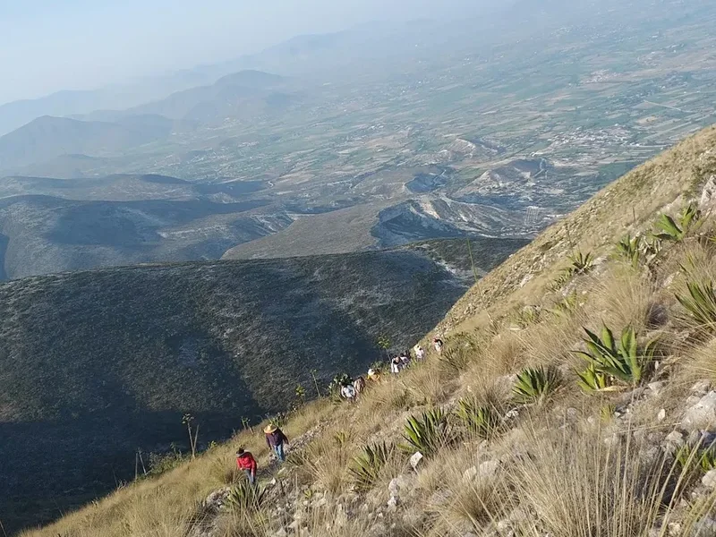
The Iztaccíhuatl Summit Route is a masterclass in high-altitude endurance. The mountain is a massive volcanic complex stretching north to south, and the standard route follows the ridgeline that forms the "body" of the woman. The climb is traditionally broken down into stages named after the "Portillos" (mountain passes) that mark the ascent. Each Portillo offers a psychological milestone and a physical transition, moving from the relatively gentle slopes of the lower mountain to the oxygen-depleted ridges of the upper massif. The terrain is notoriously varied; climbers will encounter dusty trails, loose volcanic scree that feels like walking on marbles, solid rock scrambling, and, depending on the season, firm snow or ice on the Ayoloco glacier remnants.
What sets Iztaccíhuatl apart is its proximity to Mexico City and Puebla, yet it feels worlds away from urban life. The sheer scale of the mountain is deceptive. From the trailhead at La Joya (3,950 m), the summit looks attainable, but the "false summits" of the various body parts—the Feet, the Knees, and the Belly—can be mentally taxing. The "Knees" (Las Rodillas) represent a significant hurdle, involving a steep scramble that brings climbers onto the high ridge. From here, the route traverses the "Belly" (La Panza), a high-altitude plateau that often requires crossing snowfields before the final push to the "Breast" (El Pecho), the true summit. The views throughout the climb are unparalleled, offering a 360-degree panorama of the Trans-Mexican Volcanic Belt, with the perfectly conical, ash-spewing Popocatépetl dominating the southern horizon.
Physical preparation is non-negotiable. The air at 5,000 metres contains roughly half the oxygen available at sea level, making every step a conscious effort of will. While the route is often completed as a "marathon" single-day push by elite local runners, the standard and safer approach involves a multi-day itinerary to allow the body to adjust to the thinning atmosphere. This usually involves a night at the trailhead or the high-altitude refuge, Grupo de los Cien. The mountain is a place of extremes: blistering equatorial sun during the day and bone-chilling sub-zero temperatures at night. Success on Iztaccíhuatl is not measured by speed, but by a disciplined pace, proper hydration, and a keen awareness of one’s own physiological limits in the "death zone" of high altitude.
History and Cultural Context
The history of Iztaccíhuatl is inextricably linked to the mythology of the Aztec people and the pre-Hispanic civilisations of the Valley of Mexico. The name itself is derived from the Nahuatl words "iztac" (white) and "cihuatl" (woman), referring to the snow-capped peaks that resemble a woman covered in a white shroud. According to the most famous legend, Iztaccíhuatl was a princess who fell in love with Popocatépetl, one of her father’s warriors. The king sent Popocatépetl to war in Oaxaca, promising him his daughter’s hand if he returned victorious. However, a rival suitor sent a false message back to the princess claiming that Popocatépetl had died in battle. Stricken with grief, Iztaccíhuatl died of a broken heart. When Popocatépetl returned to find his beloved dead, he carried her body to the mountains, knelt beside her, and took up a torch to watch over her forever. The gods, moved by their tragedy, covered them in snow and turned them into mountains. Popocatépetl remains active, his eruptions symbolising his eternal rage and the fire of his torch, while Iztaccíhuatl remains peaceful and dormant.
Archaeological evidence suggests that the mountain was a site of significant religious ritual long before the arrival of the Spanish. High-altitude shrines have been discovered on the slopes of Iztaccíhuatl, where priests would make offerings to Tlaloc, the god of rain, and other deities associated with water and fertility. The mountains were seen as the source of life-giving water for the valleys below, and their snowy peaks were considered sacred ground. Even today, local communities maintain a deep spiritual connection to the mountain, and it is not uncommon to see small offerings or "ofrendas" left at various points along the trail.
In the modern era, Iztaccíhuatl became a cornerstone of Mexican mountaineering. The first recorded ascent in the modern style occurred in the late 19th century, though it is almost certain that indigenous people reached high elevations centuries earlier. The establishment of the Izta-Popo Zoquiapan National Park in 1935—one of Mexico’s oldest protected areas—marked a commitment to preserving the ecological and cultural integrity of the volcanoes. Today, the mountain serves as a vital classroom for the Mexican Alpine Club and thousands of independent climbers who seek to test their mettle against one of the great peaks of the Americas.
Want more background? Read extended notes on history and cultural context → Learn more
Seasonal Highlights and Weather Reality
The climbing season on Iztaccíhuatl is dictated by the Mexican tropical wet and dry cycles. The "High Season" runs from November to March, coinciding with the dry winter months. During this window, the weather is generally stable, with clear blue skies and minimal precipitation. This provides the best conditions for summit attempts, as the volcanic scree is often frozen and more stable, and the risk of being caught in a high-altitude thunderstorm is significantly lower. However, this is also the coldest time of year; temperatures at the summit can easily drop to -10°C or -15°C, exacerbated by high winds that sweep across the exposed ridges.
The "Rainy Season" (May to September) presents a different set of challenges. While the lower slopes become lush and green, the upper mountain is frequently shrouded in cloud. Afternoon thunderstorms are common and extremely dangerous on the exposed ridges due to lightning risk. Snowfall can occur at any time of year at these altitudes, but during the rainy season, it is often heavy and wet, making the scree slopes treacherous and increasing the effort required for every step. Visibility can drop to near zero within minutes, making navigation difficult for those unfamiliar with the route's landmarks.
The shoulder months of April and October can be excellent but unpredictable. April often brings the warmest temperatures but can also see increased haze and dust from the valleys. October marks the transition out of the rainy season; the mountain is often at its most beautiful, with fresh snow on the peaks and wildflowers in the lower meadows, but climbers must be prepared for lingering storms. Regardless of the season, the "mountain weather" rule applies: conditions can change with startling rapidity. A clear morning is no guarantee of a clear afternoon, and climbers should always aim to be off the summit and descending by midday to avoid the most volatile weather patterns.
Recommended Itinerary
3-Day Acclimatisation Itinerary
Day 1: Mexico City to La Joya Trailhead
- Distance: 2 km (exploratory)
- Elevation gain: 100 m
- Time: 1–2 hours
- Depart Mexico City early morning for Amecameca to register and buy supplies
- Drive to Paso de Cortés and then to La Joya trailhead (3,950 m)
- Set up camp at La Joya or stay in a nearby lodge
- Short "acclimatisation walk" to the first Portillo to test gear and breathing
- Focus on hydration and slow movement to allow the body to adjust to the 4,000 m mark
- Early dinner and rest; sleep is often difficult on the first night at altitude
Day 2: La Joya to Refugio Grupo de los Cien
- Distance: 4 km
- Elevation gain: 770 m
- Time: 3–5 hours
- Steady ascent from La Joya through the first, second, and third Portillos
- The trail moves from alpine grass to rocky volcanic terrain
- Pass "Boca del Tiburón" (Shark's Mouth) rock formation
- Arrive at Refugio Grupo de los Cien (4,720 m) by early afternoon
- The refuge is basic and unheated; focus on staying warm and melting snow for water if necessary
- Rest and prepare gear for the midnight or 2:00 AM summit push
- This day is short in distance but the elevation gain is significant and felt in every breath
Day 3: Summit Push and Descent to La Joya
- Distance: 8 km return
- Elevation: 510 m gain to summit, 1,280 m total descent
- Time: 8–12 hours
- Alpine start (01:00–03:00) to reach the summit by sunrise
- Steep scramble up "Las Rodillas" (The Knees) to reach the main ridge
- Traverse the "Panza" (Belly) glacier/snowfield—crampons often required here
- Final ascent to "El Pecho" (The Breast) at 5,230 m
- Celebrate the summit with views of Popocatépetl and the surrounding valleys
- Careful descent back to the refuge, then continue all the way down to La Joya
- Return to Amecameca for a celebratory meal before heading back to Mexico City
Important Notes:
- The "Refugio Grupo de los Cien" is often crowded and noisy; many climbers prefer high-altitude camping nearby
- Water is not available on the mountain; you must carry all you need or melt snow (if present)
- The descent is notoriously hard on the knees due to the loose scree; trekking poles are essential
- Always check the status of Popocatépetl; if volcanic activity is high, certain areas may be closed
- Acclimatisation is the single most important factor for success; do not rush the ascent
Planning and Bookings
Book Your Trip
Everything you need to plan your journey
Accommodation
Find places to stay near Mexico City
Flights
Search flights to Mexico City
Essential Preparation
Climbing Iztaccíhuatl requires a combination of physical fitness, logistical coordination, and altitude management. You should be in excellent cardiovascular shape, as the lack of oxygen will amplify any fitness deficiencies. It is highly recommended to spend at least 2–3 days at moderate altitude (2,200 m to 3,000 m) in Mexico City or Puebla before attempting the climb. Many successful climbers include a "warm-up" hike at Nevado de Toluca (4,680 m) or Ajusco (3,900 m) in the week prior to their Iztaccíhuatl attempt.
Logistically, the town of Amecameca is your primary hub. Here, you must visit the National Park office to pay your entry fees and register your climb. The office is located in the main plaza. You can also buy last-minute supplies, including water, high-energy snacks, and basic hardware. From Amecameca, you will need to arrange transport to Paso de Cortés and then to the La Joya trailhead. While some people drive rental cars, the road from Paso de Cortés to La Joya can be rough; a high-clearance vehicle is recommended, though not always strictly necessary in the dry season.
Trail Accommodation
Accommodation on the mountain is limited and primitive, reflecting the rugged nature of the climb. There are two main options for staying overnight on the route.
Refugio Grupo de los Cien:
- Located at approximately 4,720 metres
- A basic metal hut with wooden platforms for sleeping
- Capacity: Approximately 15–20 people (often overcrowded on weekends)
- Facilities: None. No water, no heat, no toilets, no trash disposal
- Cost: Included in your park permit, but it operates on a first-come, first-served basis
- Note: The hut is notoriously cold and can be very loud with climbers preparing for alpine starts
High-Altitude Camping:
- Permitted at the La Joya trailhead and in designated areas near the refuge
- Requires a high-quality 4-season tent capable of withstanding high winds
- Offers more privacy and better sleep than the refuge, provided you have the right gear
- You must be prepared to carry the extra weight of the tent and sleeping system
What is NOT provided: There are no lodges, commercial huts, or food services once you leave Paso de Cortés. You are entirely self-sufficient. There is no reliable water source on the mountain; you must carry 4–6 litres of water per person for a two-day trip.
Required Gear
- Mountaineering boots - Stiff-soled, waterproof, and insulated. Trail runners are insufficient for the upper mountain
- Crampons and Ice Axe - Essential for the "Panza" and summit ridge, especially if there is frozen snow or ice
- Helmet - Recommended for the scramble up Las Rodillas due to potential rockfall from other climbers
- Layered Clothing System - Wicking base layer, insulating fleece/down mid-layer, and a waterproof/windproof hardshell
- Gloves - A thin liner pair and a heavy, waterproof outer pair
- Headlamp - With extra batteries; the summit push begins in total darkness
- Trekking Poles - Crucial for stability on the steep, loose volcanic scree during the descent
- Backpack - 40–50L capacity to carry gear, water, and food
- Sleeping Bag - Rated to at least -10°C or -15°C comfort level
What to Bring
- Water - 3 litres per day minimum. There are no streams or taps on the route
- High-Calorie Food - Energy gels, nuts, chocolate, and dehydrated meals. Appetite often decreases at altitude, so bring food you actually enjoy eating
- Sun Protection - High SPF sunscreen, lip balm with SPF, and Category 4 sunglasses (glacier glasses) to prevent snow blindness
- First Aid Kit - Including blister care, ibuprofen (for altitude headaches), and any personal medications
- Emergency Bivvy - A lightweight emergency shelter in case of an unplanned night on the mountain
- Navigation - GPS with offline maps and a physical map/compass as backup
- Toiletries - Biodegradable toilet paper and "wag bags" for human waste (carrying out waste is highly encouraged)
- Personal ID and Park Permit - Keep these in a waterproof bag
Permits

Access to Iztaccíhuatl is regulated by the Izta-Popo Zoquiapan National Park authorities (CONANP). Every climber is required to obtain a permit and register their itinerary before heading to the trailhead. This is not just a legal requirement but a vital safety measure, as it allows rangers to know who is on the mountain in case of an emergency or volcanic escalation.
Permit Process:
- Visit the National Park Office in Amecameca (located on the south side of the main plaza)
- Office hours are generally 9:00 AM to 4:00 PM, but it is wise to arrive early
- You will need to provide your name, nationality, age, and an emergency contact number
- Pay the park entrance fee (approximately 50–60 MXN per person, per day)
- You will receive a wristband or a paper permit; keep this accessible as rangers often check them at Paso de Cortés or La Joya
- If the office is closed, you may sometimes pay at the Paso de Cortés visitor centre, but this is less reliable
Important Considerations:
- Volcanic Activity: Popocatépetl is an active volcano. If the "Volcanic Traffic Light" (Semáforo de Alerta Volcánica) is at Yellow Phase 3 or Red, access to Iztaccíhuatl may be restricted or closed entirely. Check the CENAPRED website for daily updates
- Group Size: While there is no strict limit on group size, solo climbing is discouraged for those without extensive high-altitude experience
- Guides: While not legally mandatory for experienced mountaineers, hiring a certified local guide is highly recommended for those unfamiliar with the route or the effects of extreme altitude
Other Activities in the Area
The region surrounding the volcanoes offers a wealth of cultural and natural attractions that are perfect for pre-climb preparation or post-climb recovery:
- Amecameca Market: A vibrant traditional market where you can sample local delicacies like cecina (cured beef), blue corn tortillas, and fresh mountain cheeses. It is an excellent place to experience the local culture of the "Estado de México."
- Paso de Cortés: The high mountain pass between the two volcanoes. Even if you aren't climbing, the visitor centre offers historical exhibits and spectacular views of both peaks. It is named after Hernán Cortés, who passed through here in 1519 on his way to Tenochtitlan.
- Hacienda Panoaya: Located near Amecameca, this historic hacienda was the childhood home of the famous Mexican poet Sor Juana Inés de la Cruz. It features a museum, a labyrinth, and views of the volcanoes.
- Sacromonte: A church built on a hill in Amecameca that offers a peaceful retreat and panoramic views of the town and the mountains. It is a site of significant local pilgrimage.
- Nevado de Toluca: A few hours' drive away, this extinct volcano features two stunning turquoise lakes inside its crater. It is a popular spot for high-altitude hiking and acclimatisation.
Safety and Conditions
Altitude Sickness (AMS): Acute Mountain Sickness is the most common and serious threat on Iztaccíhuatl. Symptoms include headache, nausea, dizziness, and fatigue. The only cure for AMS is descent. If symptoms persist or worsen into HAPE (High Altitude Pulmonary Edema) or HACE (High Altitude Cerebral Edema), it is a life-threatening emergency. Never ignore a headache at 4,500 metres; communicate openly with your partners and be prepared to turn back.
Weather and Exposure: The ridge of Iztaccíhuatl is extremely exposed. High winds can make the "Panza" traverse dangerous, and lightning is a lethal threat during the rainy season. Hypothermia can occur even in summer if you become wet or exhausted. Always carry sufficient layers and a windproof shell. If a storm approaches, descend immediately; do not attempt to "wait it out" on the high ridge.
Volcanic Hazards: While Iztaccíhuatl is dormant, its neighbour Popocatépetl is very much alive. Ash falls can occur, which can irritate the lungs and eyes. More importantly, major eruptions can lead to the closure of the entire park. Always heed the warnings of the park rangers and CENAPRED. If you hear loud explosions from "Popo," stay calm but remain vigilant of the wind direction and ash clouds.
Navigation: The trail is generally well-marked with cairns and paint splashes, but in heavy fog or snow, it is easy to lose the route, especially on the scree slopes between the Portillos. A GPS with a pre-loaded track is a vital safety tool. Avoid taking "shortcuts" down the steep gullies, as these often lead to technical cliffs or unstable terrain.
Rescue Services: Mountain rescue in Mexico is primarily performed by volunteer groups like the "Socorro Alpino de México." Response times can be long due to the rugged terrain. Carrying a satellite communication device (like a Garmin inReach) is highly recommended, as mobile phone signal is spotty and unreliable on the upper mountain.
Side Trips and Points of Interest
El Solitario: A prominent rock spire located near the second Portillo. It is a popular spot for a short break and offers a unique perspective on the lower slopes of the mountain. For experienced rock climbers, there are several established routes on its volcanic walls.
The Ayoloco Glacier: Once a massive ice field, the Ayoloco has retreated significantly due to climate change. However, the remaining ice and permanent snowfields near the "Belly" are a stark reminder of the mountain's glacial history. Crossing these sections requires care and often the use of crampons in the early morning when the snow is frozen hard.
Boca del Tiburón: A distinctive rock formation between the third Portillo and the refuge that looks like the gaping maw of a shark. It is a classic photo opportunity and serves as a key navigational landmark during the ascent.
The "Feet" (Los Pies): For those with extra time and energy, a detour to the southern end of the mountain leads to the "Feet." This area is less visited than the main summit route and offers a more solitary experience with different views of the surrounding volcanic landscape.
Leave No Trace

The high-altitude environment of Iztaccíhuatl is extremely fragile. At 4,000+ metres, the growing season is short, and the soil is thin. Human impact can last for decades. As a UNESCO-recognised biosphere reserve, it is our collective responsibility to protect this landscape.
Core Principles for Iztaccíhuatl:
- Pack it in, Pack it out: This includes all trash, food scraps, and even organic waste like orange peels, which do not decompose at these altitudes.
- Human Waste: There are no toilets on the mountain. Use "wag bags" to carry out solid human waste. If you must go, bury it at least 20 cm deep and at least 100 metres from any trail or potential water source, and pack out your toilet paper.
- Stay on the Trail: Avoid creating "social trails" on the scree slopes, as this accelerates erosion and destroys the limited alpine vegetation.
- No Fires: Wood is scarce and fires are strictly prohibited. Use a lightweight camping stove for cooking.
- Respect Wildlife: You may see high-altitude rabbits (teporingos) or birds of prey. Observe them from a distance and never feed them.
- Leave What You Find: Do not take rocks, plants, or archaeological fragments. Leave the mountain as you found it for the next climber.