Iztaccihuatl Ascent - The Sleeping Woman
The Iztaccihuatl Ascent is a challenging mountain trek in Mexico, leading to the summit of the third-highest peak in the country. Known as "La Mujer Dormida" (The Sleeping Woman) due to its distinctive snow-capped silhouette resembling a reclining female figure, Iztaccihuatl offers a formidable alpine experience. This route is not for the faint of heart, demanding significant physical fitness, acclimatisation, and proper mountaineering gear. The ascent typically takes 2-3 days, involving high altitudes, potential for extreme weather, and technical sections. The journey traverses varied terrain, from volcanic scree and rock to permanent snowfields and glaciers, culminating in a breathtaking summit vista that stretches across the Mexican plateau.
- Distance: 14.0 km (one-way to summit and return to base camp)
- Elevation Gain: 1800 m
- Duration: 2-3 days
- Difficulty: Very Challenging
- Best Time: October to March (dry season)
- Highest point: 5,230 m
- Closest City: Puebla
- Trailhead Access: La Joya
- Permits: Required for national park entry
Overview
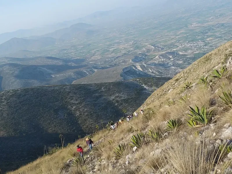
The ascent of Iztaccihuatl is a serious undertaking, often considered a stepping stone for those aspiring to climb higher peaks like Orizaba. The mountain's name derives from the Nahuatl words "iztac" (white) and "cihuatl" (woman), perfectly describing its snow-covered appearance. The trek begins at La Joya, a high-altitude starting point that immediately immerses climbers in the alpine environment. The initial stages involve navigating volcanic scree and rocky paths, gradually gaining elevation towards the mountain's flanks.
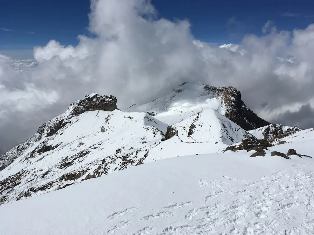
As altitude increases, the terrain transitions to more challenging surfaces, including steep slopes and, depending on conditions, snow and ice. The route often involves traversing glaciers, which necessitates the use of crampons and ice axes. Key landmarks include the "Saddle" (a significant col between the "head" and "chest" of the sleeping woman), the "Breasts" (two prominent peaks), and finally, the summit itself. The air thins considerably at these altitudes, making acclimatisation a critical factor for success and safety. The panoramic views from the summit are spectacular, offering a sweeping vista of the surrounding volcanoes, including Popocatépetl, and the vast Mexican landscape below.
The dry season, from October to March, offers the most favourable conditions, with colder temperatures but significantly less precipitation and clearer skies. However, even during this period, weather can change rapidly, and snowstorms are possible. The mountain is part of the Izta-Popo Zoquiapan National Park, a protected area that safeguards its unique volcanic and alpine ecosystems.
History and Cultural Context
Iztaccihuatl, like its neighbour Popocatépetl, holds deep cultural and mythological significance for the indigenous peoples of Mexico. According to Aztec legend, the mountain is the petrified form of a princess named Iztaccihuatl, who fell in love with a warrior named Popocatépetl. When Popocatépetl was sent to war, a rival falsely reported his death. Grief-stricken, Iztaccihuatl died of a broken heart. The gods, moved by their tragic love story, transformed them into volcanoes. Iztaccihuatl became the sleeping woman, forever watching over her beloved Popocatépetl, who became the smoking volcano.
The mountain has been a sacred site for centuries, with evidence of pre-Hispanic rituals and offerings found in the surrounding areas. Early explorers and climbers began attempting ascents in the late 19th and early 20th centuries. The first documented ascent is often attributed to American explorers in the 1880s, though indigenous peoples likely traversed its slopes much earlier for spiritual or practical reasons. The establishment of the Izta-Popo Zoquiapan National Park in 1935 aimed to preserve the natural beauty and ecological importance of these iconic volcanoes, including Iztaccihuatl.
Today, Iztaccihuatl remains a popular destination for experienced mountaineers and adventurers seeking a challenging climb and a connection to Mexico's rich natural and cultural heritage. The legends and the imposing presence of the mountain continue to inspire awe and respect.
Seasonal Highlights and Weather Reality
The best time to attempt the Iztaccihuatl Ascent is during the dry season, which generally runs from October to March. During these months, the weather is typically colder but more stable, with less rainfall and a higher probability of clear skies, offering excellent visibility from the summit.
October to March (Dry Season): This period offers the most favourable conditions for climbing. Temperatures can drop significantly, especially at higher altitudes and during the night, often falling below freezing Celsius. Snowfall is possible, and the mountain's glaciers and snowfields are more reliable. Days are shorter, with sunrise around 7:00 AM and sunset around 6:00 PM. While generally clear, unexpected storms can still occur, bringing strong winds and heavy snow.
April to September (Wet Season): This season is characterised by higher temperatures and a significantly increased chance of rainfall, often in the form of afternoon thunderstorms. These storms can bring lightning, heavy rain, and rapid temperature drops, making climbing conditions hazardous and significantly reducing visibility. Glaciers may be more exposed and potentially less stable. While ascents are still possible, they require greater flexibility and a higher tolerance for adverse weather. The risk of encountering difficult or dangerous conditions is substantially higher.
Regardless of the season, Iztaccihuatl is a high-altitude mountain, and weather can change with extreme rapidity. Climbers must be prepared for all conditions, including strong winds, freezing temperatures, and sudden storms, even during the dry season.
Recommended Itinerary
2-Day Iztaccihuatl Ascent (High Acclimatisation Assumed)
Day 1: La Joya (3,900 m) to High Camp (approx. 4,700 m)
- Morning: Arrive at La Joya trailhead. Final gear check and begin ascent.
- Late Morning/Midday: Traverse volcanic scree and rocky terrain, gradually gaining altitude. Pass through the "Paso de Cortés" viewpoint area.
- Afternoon: Reach the "Saddle" (Portillo), a significant col. Continue towards a suitable high camp location, often near the base of the main glacial ascent.
- Evening: Set up camp. Rest and hydrate. Early dinner.
- Key Waypoints: La Joya trailhead, Paso de Cortés, The Saddle (Portillo).
- Focus: Gradual ascent, acclimatisation, establishing a high camp.
Day 2: High Camp (approx. 4,700 m) to Summit (5,230 m) and Descent to La Joya
- Very Early Morning (e.g., 1:00 AM - 3:00 AM): Begin summit push.
- Pre-Dawn: Ascend steep snow and ice slopes using crampons and ice axe. Navigate glacial features.
- Sunrise: Reach the "Breasts" (Los Pechos), two prominent peaks. Continue towards the summit.
- Morning: Summit Iztaccihuatl (5,230 m). Enjoy panoramic views.
- Mid-Morning: Begin descent. This is often as challenging as the ascent, especially on snow and scree.
- Afternoon: Descend back to La Joya trailhead.
- Key Waypoints: High Camp, The Breasts (Los Pechos), Summit.
- Focus: Summit attempt, technical glacier travel, safe descent.
3-Day Iztaccihuatl Ascent (Recommended for Better Acclimatisation)
Day 1: Puebla to La Joya (3,900 m) and Hike to Lower Camp (approx. 4,300 m)
- Morning: Travel from Puebla to Amecameca, then hire transport to La Joya.
- Afternoon: Begin ascent from La Joya, hiking to a lower camp location. This allows for better acclimatisation than pushing directly to high camp on day one.
- Evening: Set up camp, rest, hydrate.
- Key Waypoints: La Joya trailhead, established lower camp site.
- Focus: Travel, initial acclimatisation, establishing a base camp.
Day 2: Lower Camp (approx. 4,300 m) to High Camp (approx. 4,700 m)
- Morning: Break camp and continue ascent towards the higher camp.
- Midday/Afternoon: Reach the high camp location, often near the base of the main glacial ascent.
- Evening: Set up camp, rest, hydrate. Prepare gear for summit push.
- Key Waypoints: Lower Camp, The Saddle (Portillo), High Camp.
- Focus: Continued acclimatisation, reaching high camp.
Day 3: High Camp (approx. 4,700 m) to Summit (5,230 m) and Descent to La Joya
- Very Early Morning (e.g., 1:00 AM - 3:00 AM): Begin summit push.
- Pre-Dawn: Ascend steep snow and ice slopes using crampons and ice axe. Navigate glacial features.
- Sunrise: Reach the "Breasts" (Los Pechos), two prominent peaks. Continue towards the summit.
- Morning: Summit Iztaccihuatl (5,230 m). Enjoy panoramic views.
- Mid-Morning: Begin descent. This is often as challenging as the ascent, especially on snow and scree.
- Afternoon: Descend back to La Joya trailhead.
- Key Waypoints: High Camp, The Breasts (Los Pechos), Summit.
- Focus: Summit attempt, technical glacier travel, safe descent.
Important Notes:
- This itinerary assumes good acclimatisation. If arriving from sea level, consider spending a day or two in Puebla (2,135 m) or Mexico City (2,240 m) beforehand.
- Hiring a local guide is highly recommended for safety and navigation, especially for glacier travel.
- Weather can change rapidly; be prepared for cold, wind, and snow.
- Carry sufficient water and high-energy food.
- This is a strenuous climb; assess your fitness honestly.
Planning and Bookings
Book Your Trip
Everything you need to plan your journey
Accommodation
Find places to stay near Puebla
Flights
Search flights to Puebla
Essential Preparation
The Iztaccihuatl Ascent requires meticulous planning due to its high altitude and challenging nature. Prior to arrival, ensure you have secured all necessary permits for Izta-Popo Zoquiapan National Park. It is crucial to arrange transportation from Puebla to Amecameca, and then to the La Joya trailhead. Taxis or 'colectivos' (shared taxis) are common options from Amecameca. Driving your own vehicle is possible, but the road can be rough, and parking at La Joya may be limited. A significant part of essential preparation involves acclimatisation. Spending at least 2-3 days at moderate altitudes (e.g., Puebla or Mexico City) before starting the ascent is highly recommended to reduce the risk of altitude sickness. Hiring a certified local guide is strongly advised, particularly for glacier travel and summit attempts, as they possess invaluable knowledge of the mountain, weather patterns, and safety protocols.
Trail Accommodation
This is a mountain track requiring overnight accommodation. There are no formal lodges or established campsites with facilities along the route. Climbers typically use alpine tents for overnight stays at designated or suitable high-altitude locations.
Accommodation Type: Alpine Tents
Location: Typically established at two main levels:
- Lower Camp: Around 4,300 metres, often situated in a more sheltered area after the initial scree slopes.
- High Camp: Around 4,700 metres, usually located near the base of the main glacial ascent, often referred to as "El Portillo" or a similar high saddle area.
Booking Requirements: No formal booking system exists for these wild camping spots. Climbers select suitable locations based on availability and conditions. However, entry into the national park requires a permit, which should be obtained in advance.
Facilities Provided: None. Climbers must be entirely self-sufficient.
What's NOT Provided: All camping equipment, food, water, cooking facilities, toilets, shelter, or any amenities. Climbers must carry everything needed for survival.
Seasonal Availability: Tents can be used year-round, but conditions vary drastically. The dry season (October-March) offers more stable weather for camping, while the wet season (April-September) presents significant challenges with rain and thunderstorms.
Costs: The primary cost associated with accommodation is the national park entry permit and potentially the cost of hiring camping gear if you do not own it.
Required Gear
- Mountaineering Boots: Sturdy, waterproof, insulated boots suitable for snow and ice travel. Must be compatible with crampons.
- Crampons: Steel crampons with 10-12 points, suitable for glacier travel and steep snow slopes.
- Ice Axe: A technical ice axe for self-arrest and general mountaineering use.
- Helmet: A climbing helmet is essential for protection against rockfall and icefall, especially on steeper sections.
- Harness: A climbing harness for glacier travel and potential rope work.
- Trekking Poles: Adjustable, sturdy trekking poles with snow baskets to aid balance and reduce strain on ascents and descents.
- Headlamp: A powerful headlamp with spare batteries is crucial for pre-dawn starts and navigating in low light.
- Navigation Tools: GPS device or smartphone with offline maps, compass, and a detailed map of the route.
- First Aid Kit: Comprehensive kit including blister treatment, pain relievers, bandages, antiseptic wipes, and any personal medications.
- Sun Protection: High SPF sunscreen (50+), lip balm with SPF, sunglasses (Category 3 or 4), and a wide-brimmed hat or cap.
- Waterproof Outerwear: High-quality waterproof and breathable jacket and trousers (e.g., Gore-Tex) with taped seams.
- Warm Layers: Multiple insulating layers including a fleece jacket, down or synthetic insulated jacket, and thermal base layers (merino wool or synthetic).
- Gloves: Warm, waterproof gloves or mittens, and thinner liner gloves.
- Beanie/Hat: Warm hat that covers the ears.
What to Bring
- Food: High-energy, lightweight food for 2-3 days. This includes breakfast items (oatmeal, energy bars), lunches (sandwiches, wraps, dried fruit, nuts), and dinners (dehydrated meals, pasta, rice). Pack extra for emergencies.
- Water Bottles/Hydration Reservoir: At least 3-4 litres capacity per person. Insulated bottles are recommended in cold weather to prevent freezing.
- Water Treatment: Water filter or purification tablets, as stream water may not be potable.
- Toiletries: Biodegradable soap, toothbrush, toothpaste, toilet paper, hand sanitiser, and any personal hygiene items.
- Sleeping Bag: A 4-season sleeping bag rated to at least -15°C to -20°C for comfort at high altitudes.
- Sleeping Pad: An insulated sleeping pad for warmth and comfort.
- Tent: A robust, 4-season mountaineering tent capable of withstanding strong winds and snow.
- Cooking Gear: Lightweight camping stove, fuel, cooking pot, utensils, mug, and lighter/matches.
- Duct Tape and Repair Kit: For emergency repairs to gear.
- Trash Bags: To pack out all waste.
- Personal Items: Camera, power bank for electronics, book or journal.
Permits
Entry into the Izta-Popo Zoquiapan National Park, which encompasses Iztaccihuatl, requires a permit. This permit is essential for all visitors, including climbers and guides. It is typically obtained from the park authorities or designated entry points. It is advisable to confirm the current permit requirements and fees well in advance of your trip, as these can change.
Where to Obtain Permits:
- Park Entrance Stations: Permits can often be purchased directly at the park's main entrance or at ranger stations near the trailhead.
- Online: In some cases, permits may be available for purchase online through official government or park websites. It is recommended to check the official CONANP (Comisión Nacional de Áreas Naturales Protegidas) website for the most up-to-date information on permit acquisition.
Permit Costs:
- The cost of the permit varies but is generally a modest fee per person per day. Expect costs to be in the range of 50-100 Mexican Pesos (MXN) per person, per day.
- Prices can differ for Mexican nationals and foreign visitors.
Important Considerations:
- Advance Purchase: While sometimes available on-site, purchasing permits in advance can save time and ensure entry, especially during peak seasons.
- Guide Requirements: While not always a strict permit requirement, hiring a certified guide is highly recommended and often mandatory for certain routes or if you lack experience. Guides will usually assist with permit acquisition.
- Park Regulations: Familiarise yourself with the park's regulations regarding camping, waste disposal, and environmental protection.
- Popocatépetl Proximity: Note that Popocatépetl is an active volcano, and its activity levels can affect access to the region. Always check current volcanic activity reports from CENAPRED (Centro Nacional de Prevención de Desastres) before your trip.
Other Activities in the Area
While the Iztaccihuatl Ascent is the primary draw, the surrounding region offers several other attractions and activities:
- Popocatépetl National Park: Explore the lower slopes and viewpoints of the active volcano Popocatépetl. While summiting Popocatépetl is generally prohibited due to its volcanic activity, designated viewpoints offer spectacular, albeit distant, perspectives.
- Amecameca: This charming town serves as a gateway to the volcanoes and offers a glimpse into traditional Mexican life. Visit its local markets, historic churches, and enjoy regional cuisine.
- Puebla City: A UNESCO World Heritage site, Puebla is renowned for its colonial architecture, vibrant Talavera pottery, and world-famous cuisine (mole poblano, chiles en nogada). It's an excellent base for acclimatisation and cultural exploration.
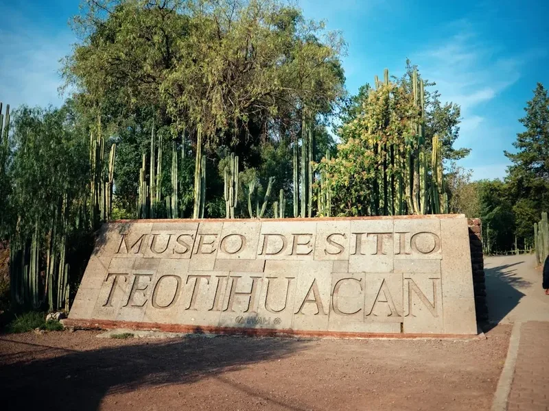
- Cholula: Famous for the Great Pyramid of Cholula, the largest pyramid in the world by volume, topped by a colonial church. It's a fascinating archaeological and historical site.
- Hiking and Trekking: Beyond Iztaccihuatl, numerous other trails exist within the national park and surrounding Sierra Nevada mountains, offering opportunities for day hikes and multi-day treks through diverse landscapes.
- Cultural Tourism: Engage with local communities, learn about indigenous traditions, and experience the rich cultural tapestry of the region.
Safety and Conditions
Altitude Sickness: This is the most significant risk. Symptoms include headache, nausea, dizziness, and fatigue. Ascend slowly, stay well-hydrated, avoid alcohol and strenuous activity on arrival, and consider medication like Diamox (acetazolamide) after consulting a doctor. If symptoms worsen, descend immediately.
Weather: Mountain weather is unpredictable. Be prepared for rapid changes, including strong winds, freezing temperatures, snow, and thunderstorms, even in the dry season. Always check the forecast before departing and be ready to turn back if conditions deteriorate.
Glacier Travel: The upper sections of Iztaccihuatl involve glacier travel. This requires proper equipment (crampons, ice axe, helmet, harness) and knowledge of glacier safety, including crevasse awareness and self-arrest techniques. Hiring a certified guide is strongly recommended for this section.
Rockfall and Icefall: Be aware of potential rock and icefall, especially on steep slopes and during warmer parts of the day. Wearing a helmet is mandatory.
Volcanic Activity: While Iztaccihuatl is considered dormant, Popocatépetl is active. Monitor reports from CENAPRED regarding volcanic activity, as ashfall or seismic events could impact the region.
Navigation: Trails can be indistinct, especially in snow or fog. Carry reliable navigation tools and know how to use them. A guide is invaluable for route-finding.
Communication: Mobile phone signal is unreliable at high altitudes. Consider carrying a personal locator beacon (PLB) or satellite messenger for emergencies.
Physical Fitness: This is a demanding climb. Ensure you have excellent cardiovascular fitness and strength, and have practiced with your gear.
Emergency Contacts: Have emergency contact numbers readily available, including local rescue services and your guide's contact information.
Side Trips and Points of Interest
The Saddle (El Portillo): This significant col is a major landmark on the route, often serving as a transition point between the initial scree slopes and the glacial ascent. It offers a dramatic change in scenery and a good spot for a brief rest and acclimatisation check before the more technical climbing begins. Views from the saddle can be expansive, providing a sense of the scale of the surrounding volcanic landscape.
The Breasts (Los Pechos): These are two prominent, often snow-covered peaks that form part of the "sleeping woman's" anatomy. Reaching Los Pechos is a significant milestone on the summit push, and they offer a challenging but rewarding section of the climb. The views from this altitude are increasingly spectacular.
Summit Views: The ultimate point of interest is the summit itself. On a clear day, the panoramic views are breathtaking. Climbers can see the vast Mexican plateau, the imposing silhouette of Popocatépetl, and numerous other volcanoes and mountain ranges stretching into the distance. It's a moment of immense accomplishment and visual reward.
Glacial Features: The glaciers on Iztaccihuatl, though receding, offer a unique alpine environment. Observing the ice formations, crevasses (with caution), and the sheer power of glacial ice adds an educational and awe-inspiring dimension to the climb.
La Joya Trailhead Area: Even the starting point at La Joya offers a sense of the high-altitude environment. The landscape is stark and beautiful, with hardy alpine vegetation and dramatic volcanic rock formations. It's a good place to appreciate the scale of the mountain before beginning the ascent.
Leave No Trace
The Izta-Popo Zoquiapan National Park is a fragile ecosystem that requires careful stewardship. Adhering to Leave No Trace principles is paramount to preserving its natural beauty and ecological integrity for future generations.
Plan Ahead and Prepare: Research the route, understand the risks, and be prepared for all conditions. Ensure you have the correct gear and sufficient food and water. Hiring a guide is part of responsible preparation.
Travel and Camp on Durable Surfaces: Stick to established trails where they exist. When camping, choose established sites or durable surfaces like rock or scree, avoiding fragile vegetation. Minimise your impact by camping at least 70 metres away from water sources.
Dispose of Waste Properly: Pack it in, pack it out. This includes all food scraps, wrappers, toilet paper, and any other refuse. Use designated toilets where available, or practice proper cathole digging techniques (at least 15 cm deep and 200 metres from water, camp, and trails) for human waste, and pack out toilet paper.
Leave What You Find: Do not remove or disturb natural objects, rocks, or plants. Respect cultural and historical sites; do not deface them.
Minimise Campfire Impacts: Campfires are generally discouraged or prohibited in high-altitude national parks due to the risk of environmental damage and the scarcity of fuel. Use a lightweight stove for cooking.
Respect Wildlife: Observe wildlife from a distance. Never feed animals, as it disrupts their natural behaviours and diets. Store food securely to prevent attracting animals.
Be Considerate of Other Visitors: Maintain a respectful distance from other groups. Keep noise levels down, especially during early morning and late evening hours. Yield to others on the trail.