Trilha do Itacolomi - The Stone Sentinel of Ouro Preto
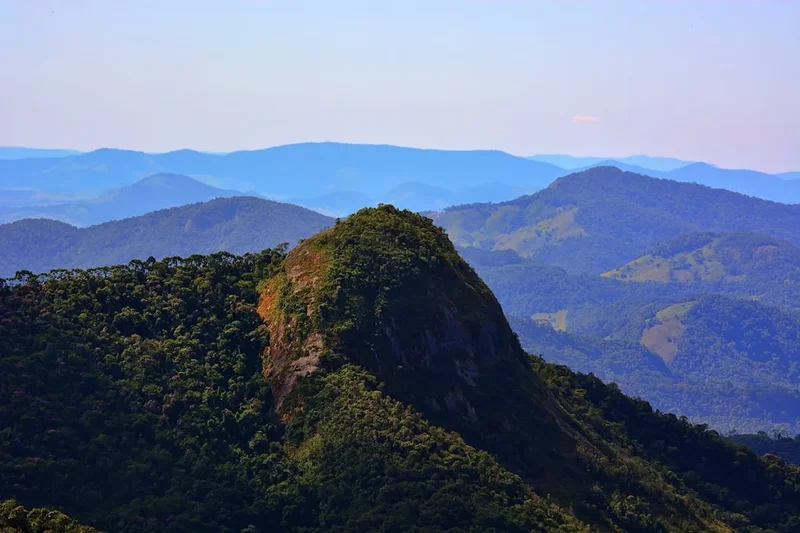
The Trilha do Itacolomi is the definitive trekking experience in the heart of Minas Gerais, leading adventurers to the summit of the iconic Pico do Itacolomi. Rising 1,772 metres above sea level, this majestic rock formation served as a vital navigational landmark for colonial bandeirantes and gold seekers during the 18th century. The journey begins within the protected confines of the Itacolomi State Park, a sprawling sanctuary of Atlantic Forest and high-altitude grasslands (campos de altitude). Hikers traverse a landscape where history and geology collide, moving from lush, shaded valleys to wind-swept ridges that offer some of the most profound panoramic views in Brazil. This is more than a physical ascent; it is a pilgrimage through the heritage of the Iron Quadrangle, demanding endurance while rewarding the spirit with an unparalleled perspective of the UNESCO World Heritage city of Ouro Preto nestled far below.
- Distance: 11.0 km return
- Duration: 5–7 hours
- Season: May–August (Dry season; provides the clearest views and safest trail conditions)
- Huts: No overnight huts on trail; day walk only
- Highest point: Pico do Itacolomi (1,772 m)
- Daily walkers: Restricted by Park capacity (registration required at entrance)
- Direction: Out-and-back route from the Park headquarters
Overview
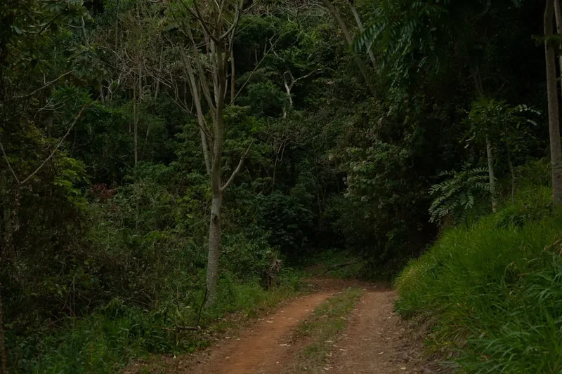
The Trilha do Itacolomi is a masterclass in elevation and ecological transition. Starting from the historic Fazenda do Manso, the trail begins as a wide, well-defined track that lures walkers into a steady rhythm. The initial phase winds through regenerating forest, where the air is heavy with the scent of damp earth and the calls of tropical birdlife. As the gradient sharpens, the dense canopy begins to thin, giving way to the unique "campos rupestres"—stony fields—characterised by hardy shrubs, vibrant orchids, and bromeliads that cling to the quartzite substrate. This shift in flora signals your arrival into the high-country, where the sun becomes more intense and the horizon begins to expand.
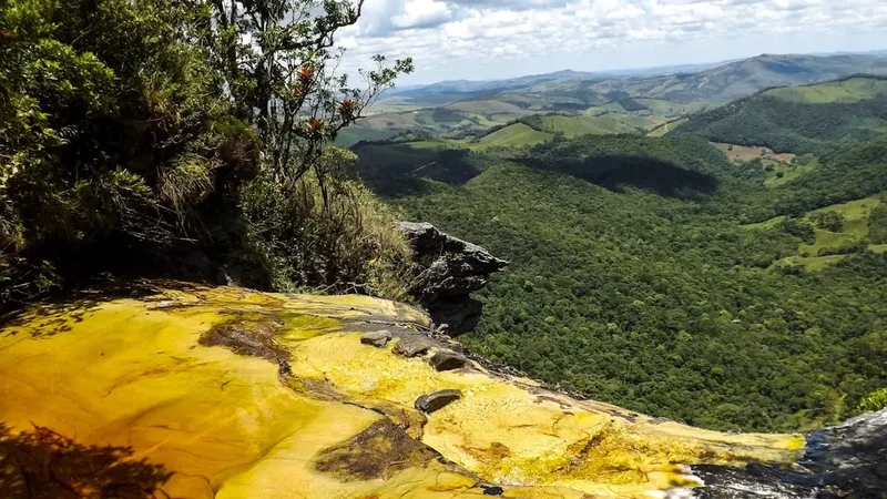
The trail's primary challenge lies in its consistent vertical gain. Hikers must ascend approximately 600 metres over the course of the trek, with the final approach to the "filhote" (the smaller rock formation next to the main peak) requiring careful footing over uneven, rocky terrain. The path is a physical dialogue with the mountain; long, lung-burning stretches are punctuated by natural balconies that offer views of the Serra do Caraça in the distance. The final push to the base of the main peak is a dramatic scramble that rewards the persistent with a 360-degree theatre of the Minas Gerais landscape. On a clear day, the jagged ridges of the Espinhaço Mountains stretch out like a frozen sea of stone.
What sets this trail apart is its profound sense of isolation despite its proximity to the bustling streets of Ouro Preto. Within an hour of walking, the sounds of the city are replaced by the whistling of the wind through the grass and the occasional screech of a hawk. The scale of the "Pedra Menino" (the smaller peak) against the massive "Pico" creates a silhouette that is unmistakable and hauntingly beautiful. This is a journey that tests your cardiovascular fitness but provides a deep, quiet satisfaction that only comes from standing atop a landmark that has guided human movement for over three centuries.
History and Cultural Context
The name "Itacolomi" is derived from the Tupi language, meaning "stone child" (ita: stone; colomi: child). This refers to the distinct geological feature where a smaller rock appears to be sitting beside the larger peak, appearing like a child at its parent's side. For the indigenous peoples of the region, these peaks held spiritual significance long before European arrival. However, it was during the Brazilian Gold Rush of the 1700s that the peak took on its most famous role. As explorers pushed inland from the coast in search of precious metals, the Pico do Itacolomi served as a "Farol dos Bandeirantes" (Bandeirantes' Lighthouse), a permanent, unmissable beacon that guided them toward the rich deposits of Vila Rica (now Ouro Preto).
The trail itself passes through the historic grounds of the Itacolomi State Park, which was once home to the Fazenda do Manso. This estate played a significant role in the agricultural support of the mining region. Today, the park serves as a vital bridge between the colonial past and environmental preservation. Walking these paths, you are following in the footsteps of poets, rebels of the Inconfidência Mineira, and naturalists like Saint-Hilaire and Spix and Martius, who explored these mountains in the 19th century to document the incredible biodiversity of the Brazilian interior. The peak is a silent witness to the rise and fall of the gold era, standing unchanged as the world below transformed from a colonial outpost into a cultural capital.
Want more background? Read extended notes on history and cultural context → Learn more
Seasonal Highlights and Weather Reality
The climate in the Serra do Espinhaço is defined by two distinct seasons: the wet and the dry. Understanding these cycles is critical for a successful and enjoyable hike to the summit. During the peak summer months (December to March), the region experiences heavy tropical rainfall. While the landscape becomes vibrantly green, the trail can become slippery, and the risk of lightning strikes on the exposed ridges makes summiting dangerous. Fog is also a frequent visitor during the wet season, often completely obscuring the very views hikers work so hard to see.
The "Golden Window" for the Trilha do Itacolomi is the dry season, spanning from May to August. During this period, the humidity drops, and the sky takes on a deep, crystalline blue hue. The temperatures are cooler, making the 600-metre climb much more manageable. However, hikers should be prepared for significant temperature swings; while it may be 25°C at the park entrance, the wind chill at the 1,772-metre summit can make it feel significantly colder. Early morning starts in June or July might even see a thin layer of frost on the high-altitude grasses.
Spring (September to November) offers a unique spectacle as the "campos rupestres" burst into bloom. This is the best time for botany enthusiasts to see rare orchids and "sempre-vivas" (everlasting flowers) in their natural habitat. However, this transition period can bring "veranicos" (unseasonably hot dry spells) or sudden afternoon thunderstorms. Regardless of the season, the weather at the peak can change in minutes; a clear sky can rapidly fill with clouds rolling in from the valley, making it essential to carry layers and waterproof gear at all times.
Recommended Itinerary
Full-Day Pico do Itacolomi Ascent
08:30 – 09:00: Arrival and Registration
- Arrive at the Itacolomi State Park main entrance near Ouro Preto.
- Complete mandatory registration and pay the entrance fee.
- Brief visit to the Visitor Centre to check the latest weather report and trail conditions.
- Ensure you have at least 2–3 litres of water, as there are no reliable sources once you begin the main ascent.
09:00 – 10:30: The Forest Ascent
- Distance: ~3 km
- The trail begins at the Fazenda do Manso, following a steady uphill gradient.
- Walk through pockets of Atlantic Forest, keeping an eye out for masked titi monkeys and diverse bird species.
- The path is wide here, allowing for easy side-by-side walking and conversation.
- This section is shaded, providing a cool environment to warm up your legs before the exposed sections begin.
10:30 – 12:00: The High Grasslands (Campos de Altitude)
- Distance: ~2.5 km
- The canopy disappears as you emerge into the high-altitude grasslands.
- The Pico do Itacolomi finally comes into full view, appearing as a massive, dark monolith against the sky.
- The terrain becomes rockier and more uneven underfoot.
- Take a break at one of the natural viewpoints to look back toward Ouro Preto and Mariana; the colonial churches appear like tiny white dots in the valley.
12:00 – 13:00: The Summit Push
- The final 500 metres involve a steeper scramble over quartzite rocks.
- Reach the base of the "Pedra Menino" for a spectacular photo opportunity with the main peak looming behind.
- Find a sheltered spot for lunch while soaking in the 360-degree views of the Iron Quadrangle.
- The sense of achievement here is immense, standing at 1,772 metres with the wind whipping across the ridge.
13:00 – 15:30: The Descent
- Distance: 5.5 km
- Retrace your steps back down the mountain.
- Be mindful of your knees on the rocky sections; the descent can be more taxing on the joints than the climb.
- The afternoon light creates a different atmosphere, casting long shadows across the valleys and highlighting the golden hues of the dry grass.
- Arrive back at the Park headquarters for sign-out and a well-earned rest at the picnic area.
Planning and Bookings
Book Your Trip
Everything you need to plan your journey
Accommodation
Find places to stay near Ouro Preto
Flights
Search flights to Ouro Preto
Essential Preparation
Unlike the multi-day Great Walks of New Zealand, the Trilha do Itacolomi does not require months of planning for hut bookings, but logistical preparation is still key to a smooth experience. The trail is located within a State Park, meaning access is strictly controlled by operating hours. It is highly recommended to stay in Ouro Preto the night before to ensure an early start, as the park usually opens at 08:00 and hikers are often discouraged from starting the summit trek after 11:00 to ensure they return before sunset.
Ouro Preto is a world-class tourist destination with accommodation ranging from historic "pousadas" in colonial mansions to modern hostels. The city has ample supermarkets and pharmacies for supplies, but specialized hiking gear is harder to find; ensure your boots and technical clothing are sorted before arriving in the region.
Trail Accommodation
There is no accommodation on the trail itself. The Trilha do Itacolomi is managed as a day-use area to protect the fragile high-altitude ecosystem.
Park Facilities (at the entrance):
- Visitor Centre with historical and ecological exhibits
- Clean toilets and changing areas
- Picnic tables and designated barbecue areas
- Parking for private vehicles and tour buses
- Small snack bar (check seasonal opening hours)
- No charging facilities or WiFi beyond the headquarters area
Required Gear
- Hiking boots: Essential. The terrain is rocky and uneven; ankle support and a "lugged" sole for grip are non-negotiable.
- Sun protection: The trail is highly exposed once you leave the forest. High-SPF sunscreen, a wide-brimmed hat, and UV-rated sunglasses are vital.
- Waterproof shell: Even in the dry season, mountain weather is unpredictable. A lightweight rain jacket doubles as a windbreaker at the summit.
- Daypack: 20-30L capacity with a comfortable harness system to carry your water, food, and layers.
- Hydration: At least 2.5 litres of water per person. There are no taps on the mountain.
What to Bring
- Nutritious lunch and high-energy snacks: Think nuts, dried fruit, and sandwiches. No food is available on the trail.
- Personal First Aid: Blister plasters, antiseptic wipes, and any personal medications.
- Warm layer: A fleece or lightweight down jacket for the summit, where temperatures are significantly lower.
- Power bank: Cold and GPS usage can drain phone batteries quickly; ensure you have a backup for navigation and photos.
- Camera/Smartphone: The views are some of the most photographed in Minas Gerais.
- Small amount of cash: For park entry fees and snacks at the visitor centre (card machines can be temperamental in the mountains).
Permits
Access to the Trilha do Itacolomi is governed by the regulations of the IEF (Instituto Estadual de Florestas). While you don't need to compete in a global lottery like the Milford Track, there are specific requirements to keep in mind.
Entry Process:
- Individual hikers must register at the park entrance gate upon arrival.
- An entrance fee is charged (currently approximately R$20-R$40, but prices are subject to change; check the official IEF website).
- For large groups or educational visits, it is recommended to contact the Park administration at least 7 days in advance.
- Guided tours are not mandatory but are highly recommended for those unfamiliar with mountain navigation or those wanting a deeper historical insight.
Park Rules:
- Strict "Leave No Trace" policy in effect.
- Pets are not allowed within the State Park to protect local wildlife.
- Alcohol and smoking are prohibited on the trail.
- Camping is strictly forbidden within the park boundaries except in specifically designated (and rare) administrative circumstances.
Other Activities in the Area
Ouro Preto and the Itacolomi State Park offer a wealth of experiences beyond the main summit trek:
- Historic Centre of Ouro Preto: Explore the steep cobblestone streets of this UNESCO site. Visit the Church of Saint Francis of Assisi, featuring masterpieces by Aleijadinho, the "Michelangelo of Brazil."
- Minas de Passagem: Descend into one of the world's largest gold mines open to the public, located between Ouro Preto and Mariana. A vintage cable car takes you deep into the crystalline galleries.
- Fazenda do Manso: Visit the historic farmhouse near the park entrance to learn about the colonial tea production and agricultural history of the region.
- Mariana: Take the tourist steam train (Trem da Vale) from Ouro Preto to the neighboring city of Mariana, the first capital of Minas Gerais.
- Lagoa da Pavuna: A shorter, easier walk within the park leads to this tranquil lake, perfect for birdwatching and a relaxed afternoon.
Safety and Conditions
Pre-Departure Checks:
- Always inform your accommodation or a friend of your expected return time.
- Check the local weather forecast specifically for "Ouro Preto - Serra" as valley weather differs from the peaks.
- Ensure your footwear is in good condition; the quartzite rocks can be extremely sharp and slippery when wet.
Mountain Hazards: The primary risks on Itacolomi are dehydration, heat exhaustion, and sudden weather shifts. The trail is exceptionally exposed for the final 3 kilometres. If you see dark clouds gathering or hear thunder, abandon the summit attempt immediately and descend below the tree line. Lightning is a genuine threat on the high-altitude ridges of Minas Gerais.
Wildlife: While generally shy, the park is home to pumas and maned wolves. Stay on the marked trail and avoid hiking alone if possible. Snake encounters (such as the jararaca) are possible; watch where you step, especially in the rocky "campos rupestres."
Emergency Contacts: Mobile signal is patchy but often available at the summit. Save the local Fire Department (Bombeiros - 193) and Park Administration numbers before you depart.
Side Trips and Points of Interest
The "Filhote" Base: For many, the base of the smaller peak (the child) is the highlight. The rock formations here are jagged and dramatic, providing a perfect foreground for photos of the massive main peak. The geology here is fascinating, with ripples in the stone showing where this land was once an ancient seabed millions of years ago.
Morro do Cachorro: A lesser-visited viewpoint along the trail that offers a different perspective of the Ouro Preto valley. It requires a short detour but is often much quieter than the main summit path.
Orchid Gullies: In the transition zone between the forest and the grasslands, there are several small, damp gullies where wild orchids thrive. In the spring, these areas become a micro-paradise for macro-photography.
Leave No Trace
The Itacolomi State Park is a sanctuary for endemic species that exist nowhere else on Earth. The "campos rupestres" are particularly fragile; a single footstep off-trail can crush plants that have taken years to grow in the nutrient-poor soil.
Your responsibility as a walker:
- Carry out all rubbish. This includes organic waste like banana skins or orange peels, which do not belong in this high-altitude ecosystem and can harm local fauna.
- Stay on the marked path. Braided trails lead to severe erosion, especially during the rainy season.
- Do not pick flowers or collect rocks. Everything in the park is protected by law.
- Respect the silence. Loud music or shouting disturbs the nesting birds and the experience of other hikers.
- Use the toilets at the Visitor Centre before starting. If you must go on the trail, follow "cat hole" procedures at least 60 metres from any dry riverbeds.