
Inca Trail - The Sacred Path to Machu Picchu
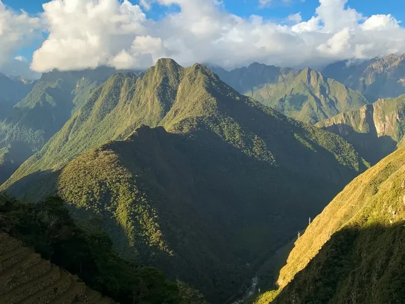
The Inca Trail (Camino Inca) is arguably the most famous hiking route in the world, a 43-kilometre journey through the heart of the Peruvian Andes that culminates at the majestic Sun Gate overlooking Machu Picchu. This is not merely a trek; it is a pilgrimage through time, traversing the same stone-paved paths laid by the Inca Empire over five centuries ago. The route winds through a staggering diversity of Andean environments, from the high-altitude alpine tundra of the "puna" to the lush, orchid-filled cloud forests of the Amazon basin. Along the way, hikers encounter numerous archaeological sites—fortresses, granaries, and ritual centres—that are inaccessible by any other means, offering a profound connection to the Tahuantinsuyo civilisation. The physical challenge of crossing high mountain passes, including the notorious Dead Woman's Pass at 4,215 metres, is rewarded by the unparalleled sensation of walking into the "Lost City of the Incas" at dawn, a moment that remains a pinnacle of travel for adventurers globally.
- Distance: 43.0 km one-way
- Duration: 4 days / 3 nights
- Season: May to September (Dry season; trail is closed in February for maintenance)
- Accommodation: Designated campsites (tents provided by organised tours)
- Highest point: Warmiwañusca / Dead Woman's Pass (4,215 m)
- Daily capacity: 500 people (including approximately 200 hikers and 300 staff)
- Direction: One-way from KM 82 to Machu Picchu
Overview
The Classic Inca Trail is a masterclass in ancient engineering and landscape integration. Unlike modern roads that seek the path of least resistance, the Inca road system (Qhapaq Ñan) was designed to connect spiritual landmarks, administrative centres, and agricultural terraces with a directness that often defies the verticality of the Andes. The 43-kilometre route is characterised by its original stone paving, steep staircases, and tunnels carved directly into the granite mountainside. For the modern hiker, the experience is one of constant transition. You begin in the relatively dry, cactus-strewn valley of the Urubamba River and ascend into the thin air of the high cordillera, where the peaks of the Vilcabamba range, such as Salkantay and Veronica, dominate the horizon with their glaciated summits.
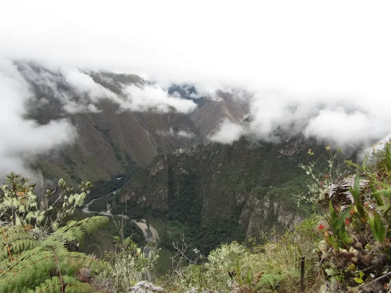
The middle section of the trail is a descent into the "Ceja de Selva" or the "eyebrow of the jungle." Here, the climate becomes humid, and the vegetation transforms into a dense tapestry of ferns, bromeliads, and over 250 species of orchids. This cloud forest environment is home to rare wildlife, including the spectacled bear and the vibrant Andean cock-of-the-rock. The trail's difficulty is rated as moderate to strenuous, primarily due to the altitude and the relentless "Inca flats"—a local euphemism for the undulating, steep stone steps that test the endurance of even the fittest walkers. However, the pace is traditionally managed by expert local guides, allowing for a deep immersion in the history and ecology of the region.
Because the trail is strictly regulated by the Peruvian government, it offers a structured and supported experience. You do not carry your own camping gear or food; instead, a team of Quechua porters—the true heroes of the trail—carries the equipment and prepares gourmet meals at each campsite. This support allows hikers to focus on the spiritual and physical journey, culminating in the final morning's walk to Inti Punku (the Sun Gate). As the morning mist clears to reveal the citadel of Machu Picchu below, the four days of exertion dissolve into a sense of profound achievement. It is a journey that combines physical rigour, archaeological wonder, and natural beauty in a way that few other places on Earth can replicate.
History and Cultural Context
The Inca Trail was part of a vast network of roads known as the Qhapaq Ñan, which stretched over 30,000 kilometres across the Incan Empire, from modern-day Colombia down to Chile and Argentina. The specific section leading to Machu Picchu was likely a royal and religious road, used by the Sapa Inca (the Emperor) and his entourage, as well as pilgrims visiting the sacred sites that line the route. Built during the height of the Inca Empire in the 15th century, the trail was abandoned during the Spanish Conquest in the 1530s. Because the Spanish never found this specific route or Machu Picchu itself, the trail remained largely intact, protected by the encroaching cloud forest for centuries.
The cultural significance of the trail is deeply tied to the Incan concept of "Ayni" (reciprocity) and their reverence for the "Apus" (mountain spirits). Every ruin along the way—from the agricultural terraces of Llactapata to the ceremonial baths of Phuyupatamarca—was positioned with astronomical and spiritual precision. The trail was "rediscovered" by the outside world following Hiram Bingham's 1911 expedition, though local families had known of the ruins for generations. Today, the trail is managed as a UNESCO World Heritage site, and the presence of the Quechua-speaking porters, many of whom are descendants of the original builders, provides a living link to the Incan past. Their knowledge of the land, the medicinal plants, and the ancient stories ensures that the trail remains a vibrant cultural corridor rather than just a museum of stone.
Want more background? Read extended notes on history and cultural context → Learn more
Seasonal Highlights and Weather Reality
The weather on the Inca Trail is dictated by the Andean seasons, which are divided into the dry season and the wet season. Because of the varied altitudes, hikers should be prepared for four seasons in a single day, regardless of when they travel.
Dry Season (May to September): This is the most popular time to hike. Days are typically clear and sunny with deep blue skies, providing the best visibility for mountain panoramas and photography. However, this is also the coldest time of year. While daytime temperatures can reach a pleasant 20°C, night-time temperatures at the higher campsites (like Pacaymayo) can drop below freezing (0°C to -5°C). June and July are the peak months, requiring bookings many months in advance.
Shoulder Seasons (April and October/November): These months offer a balance between the crowds of the dry season and the rains of the wet season. April is particularly beautiful as the landscape is still lush and green from the summer rains, and the orchids are in full bloom. October and November see an increase in rain showers, but the temperatures are slightly warmer than in mid-winter.
Wet Season (December to March): Rainfall is frequent and can be heavy, often leading to muddy trails and obscured views. However, the trail is less crowded, and the flora is at its most vibrant. Note that the Inca Trail is closed every February for essential maintenance and conservation work, although Machu Picchu remains open via train access. Hiking in the wet season requires high-quality waterproof gear and a resilient attitude toward damp conditions.
Recommended Itinerary
4-Day Inca Trail Itinerary
Day 1: Cusco to Wayllabamba
- Distance: 12 km
- Elevation gain: 300 m
- Time: 5–6 hours
- Early morning transfer from Cusco to KM 82 (Piscacucho), the official start point
- Pass through the first checkpoint and cross the Urubamba River
- Relatively flat warm-up walk alongside the river with views of the snow-capped Mount Veronica
- Visit the archaeological site of Llactapata (Patallacta), an ancient agricultural and urban centre
- Continue through the Cusichaca Valley to the village of Wayllabamba (3,000 m)
- First night of camping; a gentle introduction to the trail's terrain
Day 2: Wayllabamba to Pacaymayo (The Challenge)
- Distance: 11 km
- Elevation gain: 1,200 m
- Time: 6–7 hours
- The most physically demanding day, involving a long, steady ascent
- Climb through the "Llulluchapampa" zone, transitioning from forest to high Andean grassland
- Reach the summit of Warmiwañusca (Dead Woman's Pass) at 4,215 m, the highest point of the trek
- Spectacular views of the Vilcanota and Vilcabamba mountain ranges
- Steep descent on stone steps into the Pacaymayo Valley
- Arrive at Pacaymayo campsite (3,600 m) for a well-earned rest
- Temperatures here can be significantly colder than the previous night
Day 3: Pacaymayo to Wiñay Wayna (The Scenic Route)
- Distance: 16 km
- Elevation: 400 m gain, 1,000 m descent
- Time: 8–9 hours
- A long but incredibly rewarding day visiting multiple archaeological sites
- Ascend to the second pass (3,950 m) and visit the circular ruins of Runkurakay
- Descend to the "Town Above the Clouds," Sayacmarca, via a narrow stone staircase
- Enter the cloud forest and pass through an original Incan tunnel
- Reach the third pass and the ruins of Phuyupatamarca (Town in the Clouds), offering views of the Salkantay massif
- A long descent through dense forest to the spectacular terraces of Intipata
- Arrive at Wiñay Wayna campsite (2,650 m), the final camp before Machu Picchu
Day 4: Wiñay Wayna to Machu Picchu
- Distance: 5 km
- Elevation: Minimal gain, mostly descent
- Time: 2 hours (plus 2–3 hours exploring the citadel)
- Pre-dawn start (approx. 4:30 AM) to reach the Sun Gate for sunrise
- Final stretch of trail through lush forest with glimpses of the Urubamba River far below
- Climb the "Gringo Killer" steps—50 nearly vertical stone stairs—to reach Inti Punku (the Sun Gate)
- First panoramic view of Machu Picchu as the sun rises over the peaks
- Descent into the citadel for a guided tour of the main sectors (Temple of the Sun, Intihuatana, etc.)
- Afternoon bus to Aguas Calientes and return train to Ollantaytambo/Cusco
- The culmination of the journey, where the physical effort meets historical awe
Important Notes:
- Itineraries may vary slightly depending on the campsite assignments provided by the Ministry of Culture
- Walking poles with rubber tips are highly recommended for the steep descents
- Hydration is critical, especially on Day 2; porters provide boiled water at meal times
- The trail is a series of steep ascents and descents; there is very little "flat" walking
- Always keep your passport accessible, as it is required at multiple checkpoints
Planning and Bookings
Book Your Trip
Everything you need to plan your journey
Accommodation
Find places to stay near Cusco
Flights
Search flights to Cusco
Essential Preparation
The most critical aspect of planning an Inca Trail trek is the booking timeline. Due to strict government regulations, only 500 permits are issued per day, and these often sell out six to eight months in advance for the peak dry season (May–August). You cannot hike the Inca Trail independently; you must book through an authorised tour operator who will provide the guide, porters, and permits. When choosing an operator, prioritise those with ethical treatment policies for porters and high safety standards.
Physical preparation is equally vital. While you don't need to be an elite athlete, a good level of cardiovascular fitness and leg strength will significantly enhance your enjoyment. Training should include hiking with a small pack and, ideally, climbing stairs to prepare for the thousands of stone steps. Most importantly, you must plan for acclimatisation. Spend at least two to three days in Cusco (3,400 m) or the Sacred Valley before starting the trek to allow your body to adjust to the altitude and minimise the risk of altitude sickness.
Trail Accommodation
Accommodation on the Inca Trail consists exclusively of designated campsites managed by the Peruvian Ministry of Culture. There are no hotels or permanent lodges on the trail itself.
Hut and Camp Facilities:
- Tents: High-quality, four-season tents are provided by your tour operator (usually two people per four-person tent for extra space)
- Sleeping Mats: Basic foam mats are usually provided, but many hikers choose to rent or bring an inflatable mattress for better insulation and comfort
- Dining Tents: Large communal tents where meals are served, equipped with tables and stools
- Toilets: Most campsites have basic public toilet blocks (squat or sit-down), though many operators also provide private chemical toilet tents for their groups
- Water: Porters collect and boil water from local streams for drinking and basic washing (warm water is often provided in small basins in the morning)
- No electricity: There are no charging points at the campsites; bring portable power banks
What is NOT Provided:
- Sleeping bags (can be rented from operators in Cusco)
- Pillows and personal bedding
- Showers (some campsites have cold-water showers, but they are rarely used due to the temperature)
- Toilet paper and personal toiletries
- WiFi or mobile signal (connectivity is non-existent for most of the route)
Required Gear
- Hiking boots: Waterproof, well-broken-in, with excellent ankle support for uneven stone steps
- Daypack: 25–35L capacity with a rain cover to carry your daily essentials (water, snacks, layers)
- Waterproof jacket: A high-quality breathable shell (Gore-Tex or similar) is essential for sudden Andean downpours
- Insulating layers: A down jacket or heavy fleece for cold nights at high-altitude camps
- Walking poles: Must have rubber tips to protect the ancient Incan stonework (mandatory)
- Headlamp: Essential for navigating the campsite at night and for the pre-dawn start on Day 4
- Sun protection: High SPF sunscreen, lip balm with SPF, and a wide-brimmed hat
- Personal First Aid Kit: Including blister pads (Compeed), rehydration salts, and any personal medications
What to Bring
- Original Passport: You cannot enter the trail or Machu Picchu without the physical passport used for your booking
- Water storage: A 2–3 litre bladder (Camelbak) or reusable bottles; avoid single-use plastic bottles
- Snacks: Energy bars, nuts, dried fruit, and coca candies (helpful for altitude)
- Toiletries: Biodegradable soap, wet wipes (for "trail showers"), hand sanitiser, and a small towel
- Clothing: Moisture-wicking base layers, trekking trousers (convertible ones are great), and several pairs of high-quality wool hiking socks
- Cash: Small denominations of Peruvian Soles for tipping porters and guides, and for buying snacks or water from local villagers on Day 1
- Portable Power Bank: To keep your camera and phone charged for the duration of the trek
- Insect repellent: Essential for the lower-altitude cloud forest sections where biting midges are common
Permits
The permit system for the Inca Trail is one of the most rigid in the world, designed to preserve the archaeological integrity of the route and prevent overcrowding. Permits are released by the Peruvian Ministry of Culture once a year, typically in October or November for the following calendar year. Because the 500 daily spots include guides and porters, only about 200 permits are available for tourists each day.
Booking strategy:
- Book 6–8 months in advance if you plan to hike during the peak months of May, June, July, or August
- Provide your tour operator with accurate passport details; permits are non-refundable and non-transferable. If you renew your passport after booking, you must bring both the old and new passports on the trail
- Check the availability of permits through your chosen operator's website or the official government portal before making travel arrangements
- Be flexible with your start dates; having a 2–3 day window increases your chances of securing a permit
Costs and Regulations:
- Permit fees are included in the total price of your tour package, which typically ranges from US$600 to US$900 depending on the level of service and group size
- The permit covers entry to the Inca Trail and the Machu Picchu citadel (Circuit 5 is the standard for Inca Trail hikers)
- Children and students (under 25 with a valid University ID) may be eligible for a small discount, which must be processed at the time of booking
- The trail is closed every February for maintenance; no permits are issued for this month
Other Activities in the Area
The region surrounding Cusco and the Sacred Valley offers a wealth of cultural and adventurous experiences to complement your trek:
- Explore Cusco: Spend time in the historic centre, visiting the Qorikancha (Temple of the Sun), the Cathedral, and the bohemian neighbourhood of San Blas.
- Sacred Valley Tour: Visit the massive Incan fortresses of Ollantaytambo and Pisac, and the colourful traditional market in Pisac village.
- Maras and Moray: See the ancient salt evaporation ponds of Maras and the mysterious circular agricultural terraces of Moray, which served as an Incan laboratory.
- Rainbow Mountain (Vinicunca): A popular but challenging day trip to see the multi-coloured mineral stripes of the high Andes (5,000 m+).
- Sacsayhuamán: The monumental fortress overlooking Cusco, famous for its massive stones fitted together with incredible precision.
- Cooking Classes: Learn to make traditional Peruvian dishes like ceviche, lomo saltado, and causa in one of Cusco's many culinary schools.
- White Water Rafting: Experience the rapids of the Urubamba River for an adrenaline-filled day in the Sacred Valley.
Safety and Conditions
Altitude Sickness (Soroche): This is the primary safety concern on the Inca Trail. With the highest point at 4,215 metres, most hikers will feel some effects of the altitude. Symptoms include headache, nausea, fatigue, and shortness of breath. To mitigate this: acclimatise in Cusco for 48–72 hours, stay hydrated, avoid alcohol and heavy meals before the trek, and consider drinking coca tea (a traditional local remedy). If symptoms become severe (persistent vomiting, confusion, or difficulty breathing), you must descend immediately.
Physical Terrain: The trail consists of thousands of uneven stone steps. These can be slippery when wet and punishing on the knees during long descents. Use walking poles to reduce impact and maintain balance. Be mindful of "porter traffic"—always step to the mountain side of the trail (not the cliff side) to let porters pass safely.
Weather Extremes: Hypothermia is a risk at the high passes if you become wet and cold. Always keep your waterproof layers and a warm hat in your daypack. Conversely, the Andean sun is exceptionally strong; heat exhaustion and severe sunburn can occur even on cloudy days. Apply high-factor sunscreen and wear a hat.
Water and Food Safety: Only drink water that has been boiled or treated by your trekking team. Avoid eating raw vegetables or unpeeled fruit unless provided by your tour operator. Hand hygiene is critical; use sanitiser before every meal to prevent gastrointestinal issues.
Emergency Evacuation: There are no roads on the Inca Trail. In the event of a serious injury or illness, evacuation is typically done by stretcher to the nearest point with helicopter or rail access. Ensure your travel insurance specifically covers high-altitude trekking up to 4,500 metres and emergency medical evacuation.
Side Trips and Points of Interest
Llactapata (Patallacta): Encountered on Day 1, this is the first major archaeological site. It was an important urban and agricultural centre that supported Machu Picchu. The view from the trail above the ruins reveals the sophisticated terrace system used by the Incas to grow crops at different microclimates.
Runkurakay: A small, circular ruin located on the ascent to the second pass. Its unique shape suggests it may have served as a "tambo" (resting place) for chasquis (Incan messengers) and a lookout point over the valley below.
Sayacmarca: Perched on a protected cliff edge, this "Inaccessible Town" is reached by a steep stone staircase. It features narrow streets, ritual baths, and a complex water system, offering a glimpse into the defensive and ceremonial architecture of the Incas.
Phuyupatamarca: Known as the "Town in the Clouds," this site is one of the best-preserved on the trail. It contains six ceremonial baths and a large platform that offers a 360-degree view of the surrounding peaks, including the back of Machu Picchu mountain.
Wiñay Wayna: Often considered the most beautiful site after Machu Picchu, these ruins are built into a steep hillside overlooking the Urubamba River. The name means "Forever Young" in Quechua, referring to the orchids that grow nearby. The site features a magnificent series of agricultural terraces and a cluster of urban buildings.
Inti Punku (The Sun Gate): The final landmark before reaching the citadel. For centuries, this was the main entrance to Machu Picchu. Standing here at dawn provides the iconic first view of the ruins, framed by the surrounding peaks of Huayna Picchu and Machu Picchu Mountain.
Leave No Trace
The Inca Trail is a fragile archaeological and biological corridor. With thousands of people traversing the route each year, strict adherence to Leave No Trace principles is essential to ensure its survival for future generations. The Peruvian government has implemented several measures, such as banning single-use plastics, but the responsibility ultimately lies with the individual hiker.
Your responsibility as a walker:
- Carry out all trash, including organic waste like fruit peels, which do not decompose quickly in the high-altitude environment
- Use the provided toilet facilities at campsites and lunch spots; never leave human waste or toilet paper near the trail or ruins
- Stay on the designated stone path; cutting switchbacks causes erosion and damages the ancient stonework
- Do not touch or lean on the archaeological walls; the oils from human skin can degrade the stone over time
- Respect the wildlife; do not feed animals or pick flowers, especially the rare orchids found in the cloud forest
- Use biodegradable soaps and detergents if you must wash, and ensure you are at least 30 metres away from any water source
- Minimise noise pollution to respect both the wildlife and the spiritual experience of other hikers
By walking with respect and mindfulness, you contribute to the ongoing conservation of this world-class heritage site. Leave only footprints, and take only memories and photographs.