Ihlara Valley Trail - The Monastic Canyon of Cappadocia
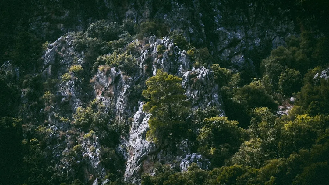
The Ihlara Valley Trail is a breathtaking 14-kilometre journey through a deep, verdant gorge carved into the volcanic landscape of central Anatolia. Unlike the arid, fairy-chimney-dotted plains typically associated with Cappadocia, Ihlara offers a lush microclimate defined by the winding Melendiz River and towering canyon walls that reach heights of up to 100 metres. This is not merely a nature walk; it is a pilgrimage through one of the world's most significant historical landscapes. Between the 4th and 14th centuries, the valley served as a secluded sanctuary for Byzantine monks, who carved thousands of dwellings and over 100 churches directly into the soft volcanic tuff. Today, the trail allows walkers to step back in time, moving between ancient frescoes and riverside tea houses, all while surrounded by the sound of rushing water and the shade of pistachio and walnut trees. It is a moderate day walk that combines geological wonder with profound cultural heritage, offering a serene alternative to the more crowded tourist hubs of the region.
- Distance: 14.0 km point-to-point
- Duration: 4–5 hours (excluding church exploration time)
- Season: Best in Spring (April–May) and Autumn (September–October)
- Elevation Gain: Approximately 200 m (mostly flat with stairs at entry/exit)
- Difficulty: Moderate (due to distance and uneven terrain)
- Highest Point: 1,220 m (at the canyon rim)
- Trailhead: Ihlara Village (South) or the Main Entrance (360 steps)
- End Point: Selime Monastery (North)
Overview
The Ihlara Valley (Ihlara Vadisi) is a geological anomaly in the heart of Turkey. Formed millions of years ago by the eruption of Mount Hasan, a nearby stratovolcano, the region was covered in thick layers of volcanic ash and lava. Over millennia, the Melendiz River eroded these soft tuff layers, creating a steep-sided canyon that stretches for roughly 16 kilometres from Ihlara Village to Selime. The result is a sheltered oasis that remains significantly cooler and greener than the surrounding Anatolian plateau. The valley's unique topography made it an ideal hiding place for early Christians fleeing Roman persecution and, later, a centre for monastic life during the Byzantine Empire. The sheer density of rock-cut architecture is staggering; it is estimated that at one point, over 80,000 people lived within the canyon's walls.
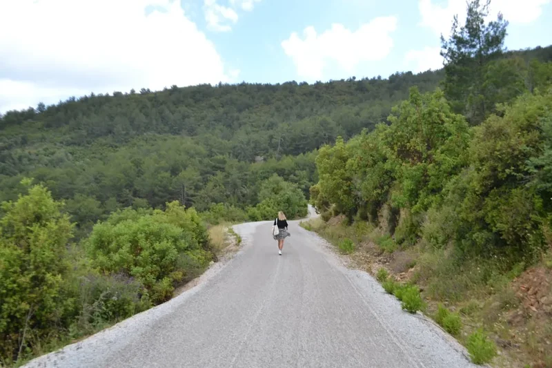
Walking the Ihlara Valley Trail is an exercise in sensory immersion. The path follows the river closely, often crossing small wooden bridges and navigating narrow sections where the canyon walls seem to lean inward. The vegetation is surprisingly diverse, featuring wild olive trees, poplars, and dense thickets of reeds that provide a habitat for a variety of birdlife, including kingfishers and golden orioles. The trail is generally well-marked, but the terrain can be rocky and muddy in sections, particularly after rain. Most walkers choose to complete the 14-kilometre stretch from Ihlara Village to Selime, though shorter loops are possible by entering at the main tourist gate (the "360 steps") and exiting at Belisırma village. However, to truly appreciate the scale of the monastic settlements and the changing character of the canyon, the full point-to-point route is highly recommended.
The experience is punctuated by the opportunity to explore the "Cave Churches of Ihlara." These are not mere ruins; many contain vibrant, though weathered, frescoes depicting biblical scenes in styles ranging from primitive "iconoclastic" designs to sophisticated Byzantine artistry. The transition from the quiet, forested southern end of the valley to the dramatic, cathedral-like rock formations of Selime in the north provides a narrative arc to the walk that few other trails can match. Whether you are a history enthusiast, a birdwatcher, or simply a hiker looking for a unique landscape, Ihlara Valley delivers a world-class experience in a relatively compact timeframe.
History and Cultural Context
The history of the Ihlara Valley is inextricably linked to the rise of Christianity in Anatolia. In the 4th century, Saint Gregory of Nazianzus, one of the Cappadocian Fathers, established a monastic community in the region. He advocated for a life of quiet contemplation and communal prayer, and the secluded Ihlara Valley provided the perfect environment for such a lifestyle. The soft volcanic rock allowed monks to easily excavate living quarters, refectories, and churches, creating a subterranean and cliff-side civilisation that remained largely invisible from the plateau above. This seclusion was vital during periods of Arab raids in the 7th and 8th centuries, as the valley served as a natural fortress.
The churches of Ihlara are unique because they represent a bridge between different artistic and theological eras. During the Iconoclastic period (726–843 AD), when the depiction of religious figures was banned, many churches were decorated with simple geometric patterns and symbolic crosses. After the ban was lifted, the "Golden Age" of Byzantine art saw the walls covered in elaborate frescoes. Unlike the churches in the Göreme Open Air Museum, which often show a unified "court style" from Constantinople, the Ihlara churches display a more provincial, diverse range of influences, including Syrian and Egyptian (Coptic) artistic elements. This suggests that the valley was a melting pot of Eastern Christian traditions.
As the Seljuk Turks moved into Anatolia in the 11th century, the valley underwent another cultural shift. Remarkably, evidence suggests that Christians and Muslims lived in relative harmony in the region for centuries. Some churches, such as the Kirkdamaltı Church (St. George), contain frescoes depicting Seljuk administrators alongside Christian saints, a rare testament to the multicultural history of the area. The monastic communities eventually declined following the population exchange between Greece and Turkey in 1923, leaving behind the silent, hauntingly beautiful rock-cut structures that hikers explore today. The valley is now protected as a first-degree archaeological and natural site, ensuring that its dual legacy as a sanctuary of faith and a masterpiece of nature is preserved.
Want more background? Read extended notes on history and cultural context → Learn more
Seasonal Highlights and Weather Reality
The Ihlara Valley experiences a continental climate, but its depth creates a sheltered environment that can differ significantly from the nearby cities of Aksaray or Nevşehir. Choosing the right time to visit is crucial for both comfort and the quality of the scenery.
Spring (April to May): This is arguably the best time to walk the trail. The Melendiz River is at its highest volume due to snowmelt from Mount Hasan, and the valley floor is a carpet of wildflowers. The temperatures are mild, typically ranging from 15°C to 22°C, making the 14-kilometre distance feel manageable. The birdlife is most active during this period, and the fresh green leaves of the poplar trees provide a vibrant contrast to the red and grey canyon walls.
Autumn (September to October): Another excellent window for hiking. The summer heat has dissipated, and the valley takes on a golden hue as the fruit trees and poplars change colour. This is harvest season in the region, and you may see local villagers gathering walnuts or grapes near the Belisırma section. Daytime temperatures are pleasant, though evenings can become quite crisp. The river is lower and calmer, making the riverside paths easier to navigate.
Summer (June to August): While the valley is cooler than the surrounding plains, it can still reach 30°C or higher. The sun reflects off the canyon walls, creating pockets of intense heat. If hiking in summer, it is essential to start at dawn and carry significant amounts of water. The advantage of summer is the lush, full canopy of trees which provides ample shade along much of the riverbank. However, this is also the peak tourist season, and the central section near the main entrance can become crowded.
Winter (November to March): Winter brings a stark, quiet beauty to Ihlara. Snow is common, and the sight of white-capped canyon walls against the dark river is spectacular. However, the trail can be treacherous; the 360 steps at the main entrance often ice over, and the riverside paths can become extremely muddy or flooded. Many of the riverside tea houses close during this period. Only experienced hikers with proper waterproof gear and traction aids should attempt the full trail in mid-winter.
Recommended Itinerary
Ihlara Valley Day Walk Itinerary
Early Morning: Arrival and Ihlara Village Start
- Start at the southern trailhead in Ihlara Village (Ihlara Kasabası).
- Avoid the main tourist entrance if you want to walk the full 14 km.
- The first 2 km are the most peaceful, winding through local orchards and small vegetable plots.
- Visit the Kokar Church (Fragrant Church) early on; it features 9th-century frescoes and a unique cruciform plan.
- The path here is narrow and follows the left bank of the river (looking downstream).
Mid-Morning: The Church Cluster and Main Entrance
- Reach the main entrance area (where the 360 steps descend from the rim).
- This section contains the highest density of accessible churches.
- Explore Ağaçaltı Church (Church under the Trees), famous for its vibrant blue and white frescoes of the Daniel in the Lions' Den.
- Visit Sümbüllü Church (Hyacinth Church), which has a beautiful facade carved into the cliff.
- Cross the river to see Yılanlı Church (Church of the Snakes), known for its dramatic depictions of sinners in the afterlife.
- Expect more foot traffic in this 3-km stretch as day-trippers descend from the stairs.
Midday: Belisırma Village Lunch Break
- Arrive at Belisırma village, roughly 7 km from the start.
- This is the only point in the canyon where cars can reach the river level.
- Enjoy a traditional Turkish lunch at one of the riverside restaurants. Many have tables set on wooden platforms directly over the rushing water.
- Try the local trout (alabalık) or a "güveç" (stew cooked in a clay pot).
- Rest and refill water supplies; the next section is more rugged and has fewer facilities.
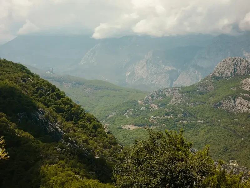
Afternoon: The Wild Northern Canyon
- Continue north from Belisırma toward Selime.
- The canyon widens, and the vegetation becomes slightly more sparse, revealing the massive scale of the cliffs.
- This 7-km section is much quieter, as most tourists end their walk at Belisırma.
- Pass the Kirkdamaltı Church (St. George), located high on the cliffside with a steep climb to reach it.
- The trail becomes more undulating here, with some short climbs away from the river to bypass narrow sections.
Late Afternoon: Selime Monastery Finale
- The trail concludes at the village of Selime.
- The "grand finale" is the Selime Monastery, the largest religious structure in Cappadocia.
- This massive complex is carved into a "fairy chimney" hill and includes a cathedral-sized church, a kitchen with a massive chimney, and stables.
- Climb through the interconnected tunnels and chambers for panoramic views of the valley you just traversed.
- Finish the walk and catch a dolmuş (minibus) or pre-arranged taxi back to Aksaray or your base in Cappadocia.
Important Notes:
- The trail is point-to-point; ensure you have transport arranged at Selime or know the minibus schedule.
- Wear sturdy hiking shoes; the path is often muddy, rocky, or slippery near the river.
- The Museum Pass Turkey is valid for the valley entrance and Selime Monastery.
- Allow at least 6 hours if you plan to explore every church thoroughly.
Planning and Bookings
Book Your Trip
Everything you need to plan your journey
Accommodation
Find places to stay near Aksaray
Flights
Search flights to Aksaray
Essential Preparation
The Ihlara Valley is located in the Aksaray Province, approximately 80 kilometres from the popular tourist centre of Göreme. While many people visit as part of an organised "Green Tour," these tours usually only walk a 3-4 km section. To do the full 14 km, you must plan independently. The nearest major city is Aksaray, but most hikers base themselves in the smaller, more atmospheric town of Güzelyurt (15 km away) or in the central Cappadocian towns like Göreme, Uçhisar, or Ürgüp.
Fitness requirements are moderate. While the trail is mostly flat as it follows the river, the total distance of 14 km on uneven ground can be tiring. Furthermore, entering or exiting via the main gate involves a steep climb of 360 steps. Ensure you have downloaded offline maps (such as Maps.me or Gaia GPS), as mobile signal can be intermittent at the bottom of the canyon.
Trail Accommodation
This is a day hike requiring no overnight accommodation within the valley itself. Camping is strictly prohibited inside the Ihlara Valley archaeological site to protect the historical structures and the natural environment.
Nearby Options:
- Ihlara Village: Several small, family-run guesthouses (pansiyons) offer basic but comfortable rooms. This is the best place to stay if you want to start the hike at sunrise.
- Belisırma: Limited accommodation, mostly focused on daytime dining, but a few small pensions exist.
- Selime: A few guesthouses are located near the monastery, convenient for those finishing late.
- Güzelyurt: Located a 20-minute drive away, this town offers beautiful "stone house" hotels and a more authentic, less touristy experience than central Cappadocia.
- Aksaray: A large city with standard business hotels, located about 40 km from the trailhead.
Required Gear
- Hiking shoes or boots: Essential. The trail involves river crossings, muddy banks, and rocky sections. Sandals are not recommended for the full 14 km.
- Sun protection: A wide-brimmed hat, high-SPF sunscreen, and sunglasses. Even in the shade, the UV levels in Anatolia are high.
- Lightweight layers: Breathable clothing for the heat, but a light windbreaker or fleece for the cooler morning start or if the wind picks up in the canyon.
- Small daypack: 15–25L to carry water, snacks, and a first aid kit.
- Trekking poles: Optional, but helpful for the uneven riverside sections and the steep climb at Selime.
- Head torch: Useful if you plan to explore the deeper, unlit corners of the cave churches or the Selime Monastery tunnels.
What to Bring
- Water: At least 2 litres per person. While there are restaurants in Belisırma, the stretches before and after can be hot and dry.
- Snacks: Energy bars, nuts, or dried fruit. There are no shops between the villages.
- Cash (Turkish Lira): Essential for the entrance fee (if you don't have a Museum Pass), riverside tea, and lunch in Belisırma. Many small vendors do not accept cards.
- Museum Pass Turkey: If you are visiting multiple sites in Cappadocia, this pass is highly cost-effective and covers Ihlara and Selime.
- Toilet paper and hand sanitiser: Public toilets at the entrance and in Belisırma may not always be fully stocked.
- Camera: With extra batteries. The frescoes and the Selime Monastery are incredibly photogenic.
Permits
No specific wilderness permits or hiking registrations are required to walk the Ihlara Valley. However, because the entire valley is a protected archaeological site and open-air museum, an entrance fee is mandatory. As of 2024, the entrance fee is approximately 15 Euros (payable in Turkish Lira), but prices are subject to frequent change due to local inflation.
Key Permit Information:
- Museum Pass: The "Museum Pass Cappadocia" or the "Museum Pass Turkey" covers the entrance to Ihlara Valley and the Selime Monastery. This is highly recommended as it allows you to bypass ticket lines.
- Operating Hours: The valley officially opens at 08:00 and closes around 19:00 in summer (17:00 in winter). You must be out of the ticketed areas by closing time.
- Ticket Validity: Your ticket is usually valid for a single entry. If you exit at Belisırma and wish to re-enter the ticketed path toward Selime, keep your ticket stub handy, although the northern section is often less strictly monitored.
- Group Size: There are no limits on group sizes for independent hikers.
Logistics and Transport:
- Getting There: From Aksaray, "Ihlara" dolmuşes run regularly. From Göreme, you will likely need to take a bus to Nevşehir, then a bus to Aksaray, and then a dolmuş to Ihlara. Alternatively, renting a car for the day is the most efficient option.
- The Return: If you leave your car at the Ihlara Village end, you can find taxis in Selime to drive you back (approx. 15-20 minutes). Negotiate the price beforehand.
Other Activities in the Area
The Ihlara Valley is located in a region rich with geological and historical wonders. Consider these nearby attractions to complement your hike:
- Selime Monastery: Even if you don't do the full hike, this rock-cut cathedral is a must-see. It is the largest of its kind in Cappadocia and served as a major religious centre and a stopover for silk road caravans.
- Güzelyurt (Gelveri): A charming town known for its "Monastery Valley" (Manastır Vadisi), which is like a smaller, quieter version of Ihlara. It also features the Church of St. Gregory, a beautiful 4th-century building converted into a mosque.
- Derinkuyu Underground City: Located about 50 km away, this is the deepest excavated underground city in Turkey, once capable of housing 20,000 people. It is a fascinating contrast to the "above-ground" caves of Ihlara.
- Mount Hasan (Hasan Dağı): For experienced mountaineers, this dormant volcano (3,268 m) offers a challenging climb with spectacular views over the Anatolian plateau and the Ihlara canyon.
- Narlıgöl Crater Lake: A stunning heart-shaped volcanic lake with thermal springs, located about 30 minutes from Ihlara. It is a peaceful spot for a picnic or a quick dip in the hot springs.
Safety and Conditions
Terrain Hazards:
- Slippery Rocks: The path frequently crosses the Melendiz River via wooden bridges or stepping stones. These can be extremely slippery when wet. Take care on the muddy banks.
- Rockfall: The canyon walls are made of volcanic tuff, which is prone to erosion. While major collapses are rare, be mindful after heavy rain or during high winds. Avoid lingering directly under overhanging cliffs.
- The 360 Steps: The main entrance staircase is steep and can be exhausting in the heat. Pace yourself and use the handrails.
Environmental Hazards:
- Heat Exhaustion: The Anatolian sun is intense. Drink plenty of water, wear a hat, and try to complete the most exposed sections of the trail before midday.
- Flash Floods: While rare, heavy thunderstorms can cause the Melendiz River to rise rapidly. If heavy rain is forecast, avoid the narrowest sections of the canyon.
- Wildlife: You may encounter small snakes or scorpions. Most are harmless, but it is wise to avoid sticking your hands into dark rock crevices or thick undergrowth.
General Safety:
- Navigation: The trail is generally easy to follow (just keep the river next to you), but some sections have multiple social paths. When in doubt, stay closer to the river.
- Communication: Mobile reception is poor at the bottom of the canyon. Inform your hotel or a friend of your expected return time.
- Emergency Services: The emergency number in Turkey is 112. However, getting a rescue team into the deeper parts of the canyon can take time.
Side Trips and Points of Interest
Ağaçaltı Church (Church under the Trees): Located near the main entrance, this is one of the most famous churches in the valley. Its frescoes are remarkably well-preserved, featuring a distinct blue background that is rare in the region. The central dome depicts the Ascension of Christ, and the walls show scenes from the life of Mary and the Magi.
Yılanlı Church (Church of the Snakes): This church is named after a fresco depicting four female sinners being bitten by snakes in hell. It is a fascinating example of the "didactic" nature of Byzantine art, intended to teach moral lessons to the monastic community. The church also contains images of the Last Judgement and the Crucifixion.
Sümbüllü Church (Hyacinth Church): This church is notable for its two-story facade and its sophisticated architectural details, including carved columns and arches that mimic traditional stone masonry. It was likely part of a larger monastery complex that included a refectory and sleeping quarters.
Kirkdamaltı Church (St. George): Located in the quieter northern section near Belisırma, this church is perched high on the cliff. It is historically significant because of an inscription mentioning the Seljuk Sultan Mesud II, proving that the Christian community continued to flourish under Turkish rule in the 13th century.
The Riverside Tea Houses: Between the main entrance and Belisırma, several enterprising locals have set up small tea gardens. Sitting on a "köşk" (a raised wooden platform with cushions) in the middle of the river while sipping hot Turkish tea is an essential Ihlara experience. It provides a moment of profound tranquility amidst the hike.
Selime Cathedral: At the very end of the trail, the Selime Monastery complex features a massive "cathedral" carved into the rock. The scale is immense, with towering pillars and a high vaulted ceiling. It is easy to imagine the chanting of monks echoing through these stone halls a thousand years ago.
Leave No Trace
The Ihlara Valley is a fragile ecosystem and a priceless historical archive. With thousands of visitors each year, the cumulative impact can be devastating if Leave No Trace principles are not followed. The frescoes, in particular, are extremely sensitive to human touch and environmental changes.
Guidelines for Responsible Hiking:
- Do Not Touch the Frescoes: The oils from human skin cause rapid degradation of the ancient pigments. Never touch, lean against, or scratch the painted surfaces.
- No Flash Photography: In many of the churches, flash photography is strictly prohibited as the intense light can fade the colours over time. Respect all posted signs.
- Pack Out All Trash: There are bins at the main entrances and in the villages, but none along the trail itself. Carry a small bag for your fruit peels, wrappers, and tissues.
- Stay on the Path: To prevent erosion and protect the valley's flora, avoid taking shortcuts up the canyon walls or through the reed beds.
- Respect the Water: The Melendiz River is the lifeblood of the valley. Do not use soaps or detergents in the river, and avoid disturbing the nesting birds along the banks.
- No Graffiti: Carving names into the soft volcanic rock is an act of vandalism that destroys history. Leave the rocks as you found them.