
Iezer-Papusa Ridge Trek
The Iezer-Papusa Ridge Trek is a challenging and rewarding mountain traverse located in the heart of Romania's Southern Carpathians, specifically within the Bucegi Mountains. This route offers a spectacular journey through dramatic alpine landscapes, characterized by rugged limestone ridges, vast glacial cirques, and panoramic vistas that stretch across the Romanian countryside. It is a trek that demands good physical condition, navigational skills, and a respect for the unpredictable mountain weather. The trail winds its way along high-altitude ridges, offering a true sense of wilderness and isolation, far from the more frequented tourist paths. This trek is an ideal choice for experienced hikers seeking an authentic mountain adventure in a less-explored European range.
- Distance: 35.0 km
- Duration: 2-3 days
- Season: July–September (summer months), dry conditions
- Difficulty: Challenging
- Highest point: Approximately 2,300 metres
- Closest City: Campulung
- Trailhead Access: Nearest Airport: Bucharest (OTP). From Bucharest, take a bus or rent a car to Campulung (approx. 3-4 hours). From Campulung, arrange a taxi or local transport to the Elena Refuge area, the typical starting point. Limited parking available.
- Coordinates: 45.4012, 25.0715
Overview
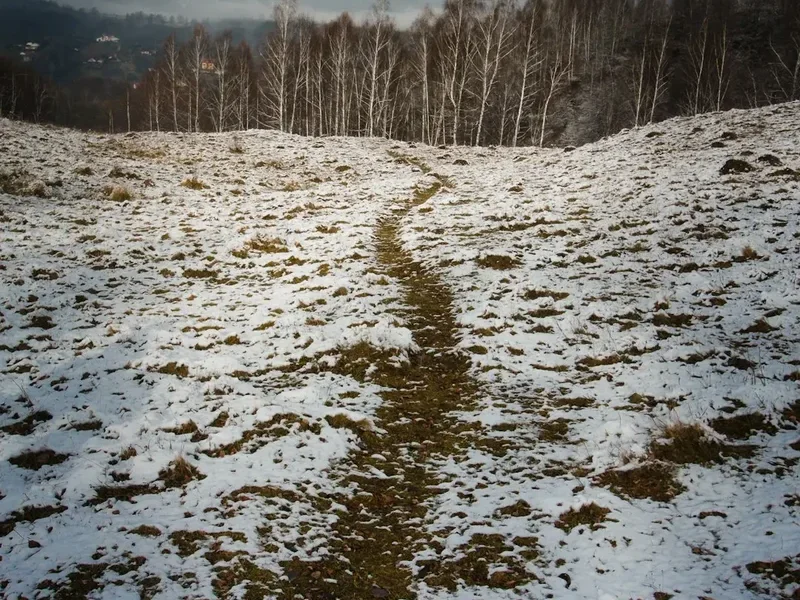
The Iezer-Papusa Ridge Trek is a demanding but immensely satisfying route that showcases the raw beauty of the Southern Carpathians. Unlike many well-trodden European trails, this trek offers a genuine sense of exploration and solitude. The journey typically begins near the Elena Refuge, a common access point for high-altitude routes in the region. From here, the trail ascends steeply, quickly gaining elevation and immersing the hiker in a subalpine environment that gradually transitions into stark, rocky alpine terrain.
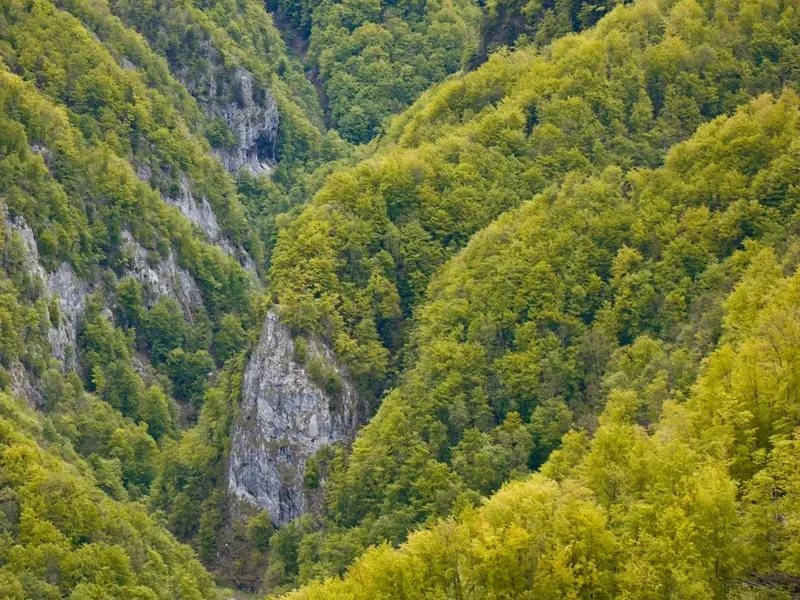
The core of the trek lies in traversing the Iezer and Papusa ridges. These are not gentle, rolling hills but rather exposed, often narrow limestone formations that require careful footing and a head for heights. The views from these ridges are breathtaking, offering sweeping panoramas of the surrounding mountain massifs, deep glacial valleys, and, on clear days, the distant plains of Wallachia. The landscape is sculpted by ancient glaciers, evident in the U-shaped valleys, cirques, and moraines that dot the terrain. The vegetation changes dramatically with altitude, from dense coniferous forests at lower elevations to alpine meadows dotted with hardy wildflowers in summer, and finally to barren rock and scree at the highest points.
The trek is best undertaken over two to three days, allowing ample time to appreciate the scenery and manage the challenging ascents and descents. Accommodation options are limited, often relying on basic mountain huts or bivouacking, which adds to the wild character of the experience. The weather in the Bucegi Mountains can be highly variable, with sudden storms, strong winds, and significant temperature drops even in mid-summer. Therefore, thorough preparation and a flexible itinerary are crucial for a safe and enjoyable trek. This route is a true test of endurance and a celebration of wild, untamed mountain landscapes.
History and Cultural Context
The Bucegi Mountains, and the Iezer-Papusa ridge in particular, have a long history of human interaction, though not in the same way as more accessible mountain ranges. For centuries, these mountains served as a natural boundary and a source of resources for the communities living in the valleys below. Shepherds have grazed their flocks in the alpine meadows during the summer months for generations, following ancient transhumance routes that have largely disappeared with modern agricultural practices. These shepherds, hardy and self-sufficient, were the true pioneers of these high-altitude paths.
The development of formal hiking trails in the Bucegi Mountains gained momentum in the late 19th and early 20th centuries, coinciding with the rise of mountaineering and tourism in Europe. Early explorers and naturalists were drawn to the dramatic geological formations and the unique flora and fauna of the range. The construction of mountain huts, often by local mountaineering clubs or forestry services, began to make these remote areas more accessible to a wider audience. The Elena Refuge, a common starting point for this trek, is a testament to this era of mountain infrastructure development, providing a basic shelter for those venturing into the higher reaches.
The Iezer-Papusa ridge itself, with its rugged and exposed nature, has historically been a more challenging objective, often tackled by experienced climbers and hikers. Its remoteness and the demanding terrain meant it was less frequented than the more accessible peaks and plateaus of the Bucegi. However, its dramatic beauty and the sense of wildness it offers have made it increasingly popular among those seeking a more adventurous and less commercialised mountain experience in Romania. The cultural context of the region is deeply rooted in rural traditions, with the mountains playing a significant role in folklore and local identity, often depicted as mystical or even dangerous places.
Seasonal Highlights and Weather Reality
The optimal period for undertaking the Iezer-Papusa Ridge Trek is during the summer months, from July to September. During this time, the weather is generally more stable, and the snow has typically receded from the higher passes and ridges, making the trails passable and safer.
Summer (July–September): This is the prime season. Days are longer, offering more daylight hours for hiking. The alpine meadows are often carpeted with wildflowers, creating a vibrant and colourful landscape. Temperatures are generally mild during the day, but can still drop significantly at night, especially at higher altitudes. This is also the period when mountain huts are most likely to be open and staffed, offering basic accommodation. However, summer in the Carpathians is also prone to sudden thunderstorms, which can develop rapidly in the afternoons. These storms can bring heavy rain, strong winds, lightning, and even hail, making exposed ridge sections extremely dangerous. Hikers must be prepared for all types of weather, including cold snaps and fog, even in July and August.
Late Spring (June): While possible, June can still see lingering snow at higher elevations, particularly on north-facing slopes and in shaded gullies. Some trails might be impassable or require snow gear and advanced navigation skills. The Elena Refuge might not yet be fully operational, and water sources could still be frozen or unreliable.
Autumn (October): Early October can still offer good hiking conditions with crisp air and beautiful autumn colours in the forests. However, the weather becomes increasingly unpredictable, with a higher chance of early snowfalls, frost, and freezing temperatures. Daylight hours decrease significantly, and mountain huts may begin to close for the season. By late October, the conditions can quickly become winter-like, making the ridge trek highly inadvisable for unprepared hikers.
Winter (November–May): The Iezer-Papusa Ridge Trek is strictly a summer activity. Attempting it during winter requires advanced mountaineering skills, specialised equipment (ice axe, crampons, avalanche safety gear), and extensive experience in winter navigation and survival. The ridges are often covered in deep snow and ice, and avalanche risk is a serious concern. The Elena Refuge is typically closed and unheated during winter.
Recommended Itinerary
2-Day Iezer-Papusa Ridge Trek Itinerary
Day 1: Elena Refuge to Iezer Hut (or bivouac site)
- Distance: Approximately 12-15 km
- Elevation gain: Approximately 1,000-1,200 m
- Time: 6-8 hours
- Start at the Elena Refuge area (approx. 1,600 m).
- Ascend through mixed forest, gradually transitioning to alpine meadows.
- Follow marked trails (often red or blue stripes) towards the Iezer peak area.
- The terrain becomes increasingly rocky and exposed as you approach the ridge.
- Reach the vicinity of Iezer Hut (a basic shelter, often unstaffed) or find a suitable bivouac spot near the summit of Iezerul Mare (approx. 2,300 m).
- Enjoy sunset views from this high vantage point.
- This day focuses on gaining significant altitude and reaching the high alpine zone.
Day 2: Iezer Hut to Papusa Peak and descent to Campulung access road
- Distance: Approximately 20-23 km
- Elevation gain: Approximately 300-400 m (along the ridge), then significant descent
- Time: 8-10 hours
- Early start to traverse the Iezer-Papusa ridge.
- Follow the red stripe marking along the exposed limestone ridge.
- Navigate carefully across rocky sections, scree slopes, and narrow crests.
- Pass over Papusa Peak (approx. 2,300 m).
- The ridge offers continuous panoramic views.
- Begin the long descent from the ridge towards the lower slopes.
- The descent route will vary depending on the exact path taken, but will eventually lead towards access roads or trails that connect back towards Campulung or a nearby village.
- Aim to reach a point where you can arrange transport back to Campulung.
- This is the most challenging day, involving a long ridge traverse and a substantial descent.
Alternative 3-Day Itinerary (for a more relaxed pace)
Day 1: Elena Refuge to a high bivouac site below Iezer Peak
- Distance: Approximately 10-12 km
- Elevation gain: Approximately 800-1,000 m
- Time: 5-7 hours
- Focus on a steady ascent through forests and meadows, reaching a comfortable altitude for camping.
- Allows more time for photography and enjoying the scenery.
Day 2: Iezer Peak, traverse to Papusa Peak, and descend to a lower bivouac/hut
- Distance: Approximately 15-18 km
- Elevation gain: Along ridge, then descent
- Time: 7-9 hours
- Traverse the main ridge, enjoying the high-altitude environment.
- Descend to a more sheltered location for the night, perhaps closer to a water source.
Day 3: Descend to Campulung access road
- Distance: Approximately 10-15 km
- Elevation loss: Significant
- Time: 4-6 hours
- A shorter final day focused on the descent and return to civilisation.
Important Notes:
- This trek is challenging and requires good physical fitness and navigational skills.
- Weather can change rapidly; always check forecasts and be prepared for adverse conditions.
- Accommodation is basic: Iezer Hut is a simple shelter, and bivouacking is common. Carry a tent or emergency bivvy.
- Water sources can be scarce at higher altitudes; carry sufficient water or a reliable purification method.
- Markings can be infrequent or faded in places; a map, compass, and GPS device are essential.
- Inform someone of your itinerary and expected return time.
Planning and Bookings
Book Your Trip
Everything you need to plan your journey
Accommodation
Find places to stay near Campulung
Flights
Search flights to Campulung
Essential Preparation
The Iezer-Papusa Ridge Trek is a serious undertaking that requires meticulous planning. Unlike more developed trails, this route offers minimal infrastructure and relies heavily on the hiker's self-sufficiency. The closest major city providing comprehensive services is Campulung. From Campulung, arranging transport to the trailhead near Elena Refuge is crucial. This typically involves hiring a local taxi or arranging a private transfer, as public transport options to remote trailheads are often limited or non-existent. It is advisable to book this transport in advance, especially if travelling during peak season. Ensure you have a reliable way to communicate with your transport provider for pick-up, as mobile signal can be intermittent in the mountains.
Given the challenging nature of the trek and the potential for unpredictable weather, it is highly recommended to build in at least one buffer day into your itinerary. This allows for flexibility in case of weather delays, unexpected trail conditions, or simply a need for a slower pace. Familiarise yourself with the route using detailed topographic maps and GPS data. Informing a trusted contact about your exact route, expected duration, and check-in times is a critical safety measure.
Trail Accommodation
Accommodation on the Iezer-Papusa Ridge Trek is extremely basic and often requires self-sufficiency. The primary points of reference are:
Elena Refuge: This is typically the starting point for the trek. It is a mountain refuge that may offer very rudimentary shelter, but it is often unstaffed and its facilities can be minimal or non-existent. It's best to consider it as a starting point rather than a reliable accommodation option.
Iezer Hut: Located at a high altitude, near the Iezer peak, this is a basic mountain shelter. It is often unstaffed and may consist of little more than a roof and four walls. It provides protection from the elements but offers no amenities such as beds, cooking facilities, or running water. Hikers should expect to sleep on the floor and bring their own sleeping mat and bag.
Bivouacking: Due to the limited availability and basic nature of huts, bivouacking (camping in a tent or emergency bivvy bag) is a common and often necessary option. There are designated or suitable wild camping spots at higher altitudes, particularly in the alpine meadows below the main ridges. It is essential to carry a lightweight, robust tent or a high-quality emergency bivvy bag, along with a warm sleeping bag and mat.
Booking Requirements: No advance booking is typically required for the Iezer Hut or for bivouacking. However, it is advisable to check with local mountaineering clubs or information centres in Campulung for the most up-to-date information on hut status and any local regulations regarding camping.
Facilities Provided: Basic shelter from wind and rain (at huts). Access to natural water sources (streams, snowmelt) which must be treated.
What's NOT Provided: Food, cooking equipment, sleeping gear, water treatment, electricity, toilets, heating, or any other amenities.
Seasonal Availability: Huts and suitable bivouac sites are generally accessible from July to September. Outside these months, snow cover can make access difficult or impossible.
Costs: If the Iezer Hut is usable, there may be a small voluntary contribution requested by local clubs, but it is generally free to use. Bivouacking is free.
Required Gear
- Sturdy hiking boots: Waterproof, with good ankle support and well broken-in.
- Waterproof and windproof jacket: Gore-Tex or similar, with taped seams. Essential for protection against sudden storms.
- Waterproof overtrousers: Full-length zips are beneficial for ease of use.
- Warm layers: Fleece or down jacket, thermal base layers (merino wool or synthetic).
- Hat and gloves: Even in summer, temperatures can drop significantly at altitude.
- Sleeping bag: Rated for at least 0°C comfort, preferably lower, for high-altitude nights.
- Sleeping mat: For insulation and comfort if bivouacking or using basic huts.
- Backpack: 45-65 litre capacity, with a rain cover.
- Head torch: With spare batteries. Essential for early starts, late finishes, or navigating huts.
- First-aid kit: Comprehensive, including blister treatment, pain relievers, antiseptic wipes, bandages, and any personal medications.
- Navigation tools: Topographic map of the area, compass, and a GPS device or smartphone with offline maps and a power bank.
- Sun protection: High SPF sunscreen, sunglasses, and a wide-brimmed hat.
- Trekking poles: Highly recommended for stability on steep ascents and descents, and for reducing strain on knees.
What to Bring
- Food: Sufficient high-energy, lightweight food for 2-3 days (breakfasts, lunches, dinners, snacks). No food is available on the trail.
- Water bottles or hydration reservoir: Capacity of at least 2-3 litres per person.
- Water purification method: Filter, purification tablets, or UV steriliser. Natural water sources must be treated.
- Cooking equipment (if bivouacking): Lightweight stove, fuel, pot, mug, spoon/spork, lighter/matches.
- Toiletries: Biodegradable soap, toothbrush, toothpaste, toilet paper, hand sanitiser. Pack out all waste.
- Emergency bivvy bag or lightweight tent: For overnight stays.
- Personal Locator Beacon (PLB) or satellite messenger: Highly recommended for remote areas with no mobile signal.
- Duct tape and cordage: For repairs.
- Small trowel: For burying human waste if not using designated facilities (pack out toilet paper).
- Camera and spare batteries/power bank.
- Cash: For potential transport or small purchases in Campulung.
Permits
For the Iezer-Papusa Ridge Trek, formal permits are generally not required for hiking or bivouacking in the Bucegi Mountains, as it is largely considered a wilderness area accessible to the public. However, it is always prudent to check for any local regulations or changes in access rules before your trip. Information can often be obtained from the nearest National Park authority or mountaineering club in Campulung.
National Park Regulations: While specific permits for hiking are uncommon, visitors are expected to adhere to general National Park rules. These typically include:
- Staying on marked trails where they exist to minimise environmental impact.
- Proper disposal of waste – pack out everything you pack in.
- Respecting wildlife and not feeding animals.
- Campfires are often restricted or prohibited in sensitive alpine areas; check local guidelines.
- Respecting any designated camping areas or restrictions.
Hut Usage: As mentioned, the Iezer Hut is a basic shelter and does not operate on a booking system. It is available on a first-come, first-served basis. If you plan to use it, be prepared for the possibility that it may already be occupied or in poor condition.
Bivouacking: Wild camping or bivouacking is generally tolerated in designated areas away from the main trails and huts, provided it is done responsibly and with minimal impact. It is advisable to camp in areas that have been previously used for camping, if possible, and to ensure you leave no trace of your presence.
Transport to Trailhead: While not a permit, arranging transport to the Elena Refuge area is a critical logistical step. This often involves private hire, and it's wise to confirm arrangements and costs well in advance.
Recommendation: Before your trip, it is highly recommended to contact the nearest tourist information centre or a local mountaineering club in Campulung. They can provide the most current information regarding trail conditions, any specific regulations, and advice on local transport and safety.
Other Activities in the Area
While the Iezer-Papusa Ridge Trek is the primary draw, the region around Campulung and the Bucegi Mountains offers several other activities for those looking to extend their stay or explore further:
- Exploring Campulung: The town itself has historical significance, with remnants of its past as a medieval capital. Visit the Princely Court (Curtea Domnească), the Old Princely Church (Biserica Domnească), and wander through the charming old town centre.
- Day Hikes in the Bucegi Mountains: Numerous other trails exist within the Bucegi range, offering varying levels of difficulty. Popular options include hikes to the Sphinx and Babele rock formations (accessible via cable car from Busteni, though this is a different part of the range), or exploring the Piatra Craiului National Park, known for its dramatic limestone ridge.
- Sinaia and Peles Castle: A scenic drive or train journey can take you to Sinaia, a beautiful mountain resort town famous for the stunning Peles Castle, a former royal residence and one of Romania's most impressive palaces.
- Transfagarasan Highway (seasonal): If travelling during the summer months when it is open (typically July-October), the Transfagarasan Highway is one of the most spectacular mountain roads in the world, offering breathtaking views and engineering marvels. It is accessible from the southern side of the Carpathians, though a significant detour from Campulung.
- Local Cuisine: Enjoy traditional Romanian food in local restaurants and inns. Sample dishes like sarmale (cabbage rolls), mămăligă (polenta), and various grilled meats, often accompanied by local wines or țuică (plum brandy).
- Caving: The Bucegi region has several cave systems, though access and guided tours may vary. Research local options if interested in subterranean exploration.
Safety and Conditions
Pre-Departure Checks:
- Weather Forecast: Always check the most up-to-date mountain weather forecast for the Bucegi Mountains before and during your trek. Websites like Mețeo România or specific mountaineering forecast sites are invaluable. Be aware that forecasts can change rapidly.
- Trail Conditions: Consult with local mountaineering clubs or park authorities in Campulung for the latest information on trail conditions, snow levels, and any potential hazards.
- Emergency Contacts: Ensure you have the emergency numbers for Romanian mountain rescue (Salvamont) programmed into your phone, though signal is unlikely to be available on the ridge.
- Inform Someone: Leave a detailed itinerary with a trusted friend or family member, including your planned route, expected return time, and emergency contact information.
Ridge Exposure and Weather: The Iezer-Papusa ridge is highly exposed. Sudden storms, including thunderstorms, high winds, and heavy rain or hail, are common, especially in the afternoons during summer. Hypothermia is a significant risk, even in summer, due to wind chill and wet conditions. If a storm approaches, descend from the ridge immediately and seek shelter in a valley or a more protected area. Do not attempt to traverse the ridge during lightning storms.
Navigation: While some sections may be marked (e.g., red stripes), markings can be infrequent, faded, or absent in places. Relying solely on trail markings is not advisable. A good topographic map, a compass, and a GPS device or smartphone with offline maps are essential. Familiarise yourself with the route and key landmarks before you start.
Water Sources: Water is generally available from streams and snowmelt at higher altitudes, but it must be treated before consumption. Carry a reliable water filter or purification tablets. In dry periods, water sources can become scarce, so carry sufficient water capacity.
Physical Demands: This trek is physically demanding, involving significant elevation gain and loss, and often requires scrambling over rocky terrain. Ensure you are adequately fit and have practiced with your gear before undertaking the trek.
Wildlife: While large predators like bears are present in the Carpathians, encounters on the high ridges are rare. However, be aware of your surroundings and store food properly if bivouacking. The main concern is often smaller wildlife and insects.
Communication: Mobile phone signal is unreliable to non-existent on the ridge. Consider carrying a Personal Locator Beacon (PLB) or a satellite messenger for emergencies.
Side Trips and Points of Interest
Iezerul Mare Peak: The highest point on the trek, often considered the start of the main ridge traverse. Reaching this summit offers a sense of accomplishment and provides the first expansive panoramic views of the surrounding mountain landscape. It's a crucial waypoint for orientation.
Papusa Peak: The other significant peak along the ridge. The traverse between Iezerul Mare and Papusa is the most exposed and visually dramatic section of the trek. The views from Papusa are equally stunning, offering a different perspective on the vastness of the Bucegi Mountains.
Glacial Cirques and Valleys: As you ascend and descend, you will pass through or overlook ancient glacial cirques and U-shaped valleys. These geological features are a testament to the powerful forces that shaped the landscape over millennia and offer excellent opportunities for photography and appreciating the scale of the mountains.
Alpine Flora and Fauna: During the summer months, the alpine meadows are often adorned with a variety of wildflowers. Keep an eye out for hardy alpine plants adapted to the harsh conditions. While less common at these altitudes, you might spot chamois or other mountain wildlife. The birdlife can also be interesting, with species adapted to high-mountain environments.
Panoramic Vistas: The entire ridge offers continuous, breathtaking panoramic views. On clear days, you can see far across the Bucegi massif, the Piatra Craiului Mountains, and potentially even the distant plains of Wallachia. The changing light throughout the day, especially at sunrise and sunset, can create spectacular photographic opportunities.
The Elena Refuge Area: Even before reaching the main ridge, the area around the Elena Refuge offers a glimpse into the subalpine environment, with forests and meadows that transition into the more rugged terrain above. It serves as a good acclimatisation point and a place to prepare for the ascent.
Leave No Trace
The Iezer-Papusa Ridge Trek traverses a wild and relatively untouched mountain environment. Adhering to Leave No Trace principles is paramount to preserving its natural beauty and ecological integrity for future generations. As you are likely to be in remote areas with minimal infrastructure, your personal responsibility is amplified.
Plan Ahead and Prepare: Understand the terrain, weather, and potential hazards. Carry appropriate gear and sufficient food and water. Inform someone of your plans.
Travel and Camp on Durable Surfaces: Stick to established trails where they exist. If bivouacking, choose established or previously used sites. Avoid setting up camp on fragile alpine meadows or near water sources. Camp at least 70 metres away from lakes and streams.
Dispose of Waste Properly: Pack out everything you pack in, including all food scraps, wrappers, and any other litter. Human waste should be disposed of properly: dig a cathole at least 15-20 cm deep and 70 metres away from water, camp, and trails. Pack out used toilet paper. If using huts, follow any posted instructions for waste disposal.
Leave What You Find: Do not disturb or remove any natural objects, plants, or historical artefacts. Take only photographs and memories.
Minimise Campfire Impacts: Campfires are generally discouraged in alpine environments due to their impact on vegetation and the risk of wildfires. If permitted and absolutely necessary, use a lightweight stove for cooking. If a campfire is permitted, keep it small, use existing fire rings, and ensure it is completely extinguished before leaving.
Respect Wildlife: Observe wildlife from a distance. Never feed animals, as this can disrupt their natural behaviours and diets, and can be harmful to their health. Store food securely to prevent attracting animals.
Be Considerate of Other Visitors: While this trek offers solitude, you may encounter other hikers. Keep noise levels down, yield to others on narrow trails, and maintain a respectful distance. The goal is to enjoy the wilderness without negatively impacting it or the experience of others.