Ice Lakes Basin Trail
The Ice Lakes Basin Trail is a challenging and rewarding day hike located in the San Juan Mountains of Colorado, USA. This trail offers a spectacular alpine experience, leading hikers through diverse terrain to a series of stunning, glacially-carved lakes nestled within a dramatic basin. Known for its vibrant blue waters, rugged peaks, and high-altitude environment, the Ice Lakes Basin Trail is a must-do for experienced hikers seeking breathtaking scenery and a true taste of the Colorado Rockies.
- Distance: 11.9 km (round trip)
- Elevation Gain: 914 m
- Duration: 5–7 hours
- Difficulty: Challenging
- Best Time: July to September
- Closest City: Silverton, Colorado
- Trailhead Access: High-clearance 4WD vehicle recommended for the final approach.
Overview
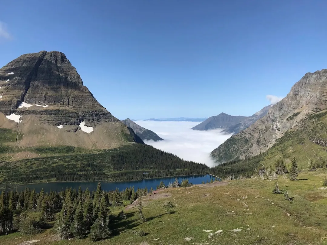
The Ice Lakes Basin Trail is a quintessential Colorado alpine hike, renowned for its dramatic elevation gain and the unparalleled beauty of its destination. The journey begins with a steady ascent through dense evergreen forests, gradually opening up to subalpine meadows dotted with wildflowers during the summer months. As you climb, the views expand, offering glimpses of the surrounding peaks and valleys of the San Juan Mountains.
The trail's character shifts significantly as you gain altitude. The initial forest section gives way to more exposed slopes, where the landscape becomes increasingly rugged and rocky. The final push to the basin involves navigating steep, scree-covered sections and rocky steps, demanding good physical fitness and sure footing. However, the effort is handsomely rewarded upon reaching the Ice Lakes themselves.
The basin is home to several distinct lakes, with the most famous being the vibrant, almost impossibly blue Ice Lake. This striking colour is a result of glacial silt suspended in the water, reflecting the sky and creating a mesmerising spectacle. Adjacent to Ice Lake is Island Lake, another beautiful alpine tarn, and further exploration can lead to other smaller, unnamed lakes and tarns within the basin. The surrounding peaks, including Vermillion Peak and Fuller Peak, provide a dramatic, jagged backdrop, creating a truly awe-inspiring alpine amphitheatre.
This hike is best undertaken during the summer and early autumn months when snow has melted from the higher elevations, and the weather is generally more stable. However, mountain weather can change rapidly, and hikers should always be prepared for sudden storms, including hail and snow, even in July and August. The high altitude also means that conditions can be cool, even on sunny days.
History and Cultural Context
The San Juan Mountains, where the Ice Lakes Basin Trail is located, have a rich history deeply intertwined with mining and indigenous peoples. For centuries, the Ute people utilized these mountains for hunting and seasonal migration, their lives intrinsically connected to the land's natural resources.
The latter half of the 19th century saw a significant influx of prospectors and miners drawn by the promise of silver and gold. The area around Silverton, the closest city to the trailhead, boomed during this era, with numerous mines established in the surrounding peaks. While the Ice Lakes Basin itself may not have been a primary mining site due to its remote and rugged nature, the trails and access roads in the region often originated from or were influenced by the mining industry's infrastructure development.
The transformation of these rugged mountain paths into designated hiking trails reflects a shift in human interaction with the San Juans, from resource extraction to recreation and conservation. The preservation of areas like the Ice Lakes Basin as accessible, yet wild, natural spaces is a testament to the growing appreciation for the ecological and aesthetic value of these high-altitude environments. The trail's current form is a result of ongoing efforts by land management agencies and volunteer groups to maintain and improve access while minimising environmental impact.
Seasonal Highlights and Weather Reality
The Ice Lakes Basin Trail is a highly seasonal hike, with its accessibility and beauty dictated by the harsh mountain climate.
Summer (July to September): This is the prime season for hiking the Ice Lakes Basin Trail. By July, most of the snow has typically melted from the trail, revealing the vibrant alpine meadows bursting with wildflowers. The lakes are at their most stunning, with their characteristic brilliant blue hue. The weather is generally more stable, with longer daylight hours. However, afternoon thunderstorms are common in the Rockies during summer, so starting early is crucial. Temperatures can range from cool in the mornings to pleasantly warm in the midday sun, but always be prepared for rapid changes.
Late Spring (June): While some hardy hikers may attempt the trail in June, it is generally still too early. Significant snowpack often lingers at higher elevations, making the trail difficult to follow and potentially dangerous, especially on the steeper sections and around the lakes. Ice can persist on the lakes well into July.
Autumn (October): As autumn approaches, the wildflowers fade, and the landscape begins to transform. The aspen trees in the lower elevations may turn golden, offering beautiful colours. However, the weather becomes increasingly unpredictable. Snowfall can occur at any time, and the trail can become hazardous. Daylight hours shorten, and temperatures drop significantly. By late October, the trail is often impassable due to snow.
Winter (November to May): The Ice Lakes Basin Trail is completely inaccessible and dangerous during the winter months due to heavy snowfall, avalanche risk, and extreme cold. It is strictly a summer and early autumn hike.
Weather Considerations: Regardless of the season, mountain weather is notoriously fickle. Be prepared for all conditions: sunshine, wind, rain, hail, and even snow. Afternoon thunderstorms are a significant hazard, often bringing lightning and rapidly deteriorating visibility. Always check the forecast before you go and be willing to turn back if conditions worsen.
Recommended Itinerary
Ice Lakes Basin Trail - Day Hike Itinerary
Early Morning (Approx. 6:00 AM - 7:00 AM): Departure from Silverton
- Drive from Silverton towards the trailhead.
- The final approach via County Road 7/Forest Road 585 is rough and requires a high-clearance 4WD vehicle. Allow ample time for this section.
- Arrive at the trailhead parking area. Parking is limited and fills quickly, especially on weekends.
Morning (Approx. 7:00 AM - 11:00 AM): Ascent through Forest and Meadows
- Begin the hike from the trailhead (elevation approx. 3,350 m).
- The initial 3.2 km of the trail climbs steadily through dense evergreen forest.
- The trail then emerges into subalpine meadows, offering the first expansive views.
- Continue climbing, passing by smaller tarns and enjoying the changing vegetation.
- The gradient becomes steeper as you approach the basin.
Midday (Approx. 11:00 AM - 1:00 PM): Reaching the Lakes and Lunch
- Arrive at the junction for Ice Lake and Island Lake.
- Continue the steep ascent to Ice Lake (elevation approx. 3,870 m).
- Spend time admiring the vibrant blue waters of Ice Lake and the surrounding peaks.
- Explore Island Lake, located a short distance away.
- Enjoy your packed lunch with panoramic views of the basin.
Afternoon (Approx. 1:00 PM - 4:00 PM): Descent and Return to Trailhead
- Begin the descent back down the trail.
- Exercise caution on the steep and rocky sections, especially during the descent.
- Continue through the meadows and forest.
- Arrive back at the trailhead parking area.
Late Afternoon (Approx. 4:00 PM onwards): Return to Silverton
- Drive back to Silverton.
- Allow for potential delays on the rough access road.
Important Notes:
- This is a challenging day hike due to the significant elevation gain and high altitude.
- Start as early as possible to avoid afternoon thunderstorms and to allow ample time for the hike.
- Carry plenty of water and high-energy snacks.
- Be prepared for rapidly changing weather conditions.
- The trailhead parking is very limited; arrive early or consider a weekday hike.
Planning and Bookings
Book Your Trip
Everything you need to plan your journey
Accommodation
Find places to stay near Silverton
Flights
Search flights to Silverton
Essential Preparation
The Ice Lakes Basin Trail is a demanding hike that requires careful planning and preparation. Given its challenging nature and remote location, ensuring you are physically prepared and have the necessary logistics in place is paramount. The closest major town is Silverton, Colorado, which offers basic amenities, lodging, and dining options. Durango, approximately 1.5 hours away, has a larger airport (Durango-La Plata County Airport - DRO) and more extensive services.
Fitness: This hike involves a significant elevation gain of 914 metres over a relatively short distance, reaching an altitude of nearly 3,900 metres. Hikers should have a good level of cardiovascular fitness and be accustomed to hiking on steep, uneven terrain. Acclimatisation to high altitude is highly recommended; spending a day or two in Silverton or a similar altitude before tackling the hike can significantly reduce the risk of altitude sickness.
Logistics: Access to the trailhead is via County Road 7/Forest Road 585, which is a rough, unpaved road. A high-clearance 4WD vehicle is strongly recommended, and in some conditions, may be essential. Standard passenger cars are not suitable for this road. Ensure your vehicle is in good condition and you are comfortable driving on challenging off-road terrain. Parking at the trailhead is extremely limited and can fill up by early morning, especially on weekends and holidays. Arriving very early is advised.
Base Town: Silverton, Colorado, is the most convenient base. It offers a range of accommodation from historic hotels to motels and campgrounds. It also has restaurants, grocery stores, and outdoor gear shops. However, services are more limited than in larger cities.
Trail Accommodation
This is a day hike requiring no overnight accommodation. Hikers typically start from Silverton or a nearby area and complete the trail within a single day.
Required Gear
- Sturdy Hiking Boots: Waterproof, broken-in hiking boots with good ankle support are essential for navigating the rocky and uneven terrain.
- Backpack: A comfortable daypack (20-35 litres) to carry essentials.
- Layered Clothing: Due to the high altitude and potential for rapid weather changes, bring multiple layers. This includes a moisture-wicking base layer, an insulating mid-layer (fleece or down jacket), and a waterproof and windproof outer shell.
- Rain Gear: A waterproof jacket and trousers are crucial, as mountain storms can appear quickly.
- Navigation Tools: A map of the area, a compass, and a GPS device or smartphone with downloaded offline maps are highly recommended. While the trail is generally well-marked, visibility can be poor in fog or storms.
- Headlamp or Flashlight: With extra batteries, in case of an early start or late finish.
- Sun Protection: High SPF sunscreen, sunglasses, and a wide-brimmed hat are vital due to the intense sun at high altitudes.
- First-Aid Kit: Comprehensive kit including blister treatment, pain relievers, antiseptic wipes, bandages, and any personal medications.
- Trekking Poles: Highly recommended for stability on steep ascents and descents, and to reduce strain on knees.
What to Bring
- Water: Carry at least 2-3 litres of water per person. Water sources are available along the trail, but purification (filter or tablets) is essential if you plan to refill.
- Food: High-energy snacks and a substantial lunch are necessary. Examples include trail mix, energy bars, sandwiches, fruit, and jerky.
- Water Treatment: A water filter or purification tablets are recommended if you plan to drink from natural sources.
- Toiletries: Biodegradable toilet paper, hand sanitiser, and a small trowel for digging catholes if you need to go off-trail (pack out all toilet paper).
- Insect Repellent: Especially important during summer months for mosquitoes and biting flies.
- Emergency Shelter: A lightweight emergency blanket or bivvy sack can be a lifesaver in unexpected situations.
- Whistle: For signalling in emergencies.
- Camera: To capture the stunning scenery.
- Cash: For potential small purchases or donations if applicable.
Permits
Currently, no permits are required for day hiking on the Ice Lakes Basin Trail. However, it is always advisable to check with the relevant land management agency (e.g., the U.S. Forest Service) for any last-minute changes or specific regulations, especially regarding overnight camping if that were to be considered (though this is a day hike). While no permits are needed, it is good practice to register your hike at the trailhead if a registration box is available. This helps authorities track visitor numbers and provides valuable information in case of an emergency.
Important Considerations:
- Parking: As mentioned, parking at the trailhead is extremely limited. Arrive very early, ideally before sunrise, to secure a spot. If the lot is full, you may need to find alternative parking further down the road and walk to the trailhead, adding significant time and distance to your day.
- Vehicle Requirements: Ensure your vehicle is suitable for the rough access road. A high-clearance 4WD is strongly recommended.
- Group Size: While not strictly regulated for day hikes, it's generally good practice to hike in small groups for safety and to minimise impact on the environment.
Other Activities in the Area
The San Juan Mountains surrounding Silverton offer a wealth of activities for outdoor enthusiasts:
- Hiking: Numerous other trails exist in the region, ranging from easy valley walks to challenging multi-day treks. Consider the nearby Molas Pass area or trails leading to other high-altitude lakes.
- Jeeping and Off-Roading: The extensive network of old mining roads provides excellent opportunities for exploring the backcountry in a 4WD vehicle.
- Mountain Biking: Trails around Silverton cater to various skill levels, offering thrilling descents and scenic rides.
- Via Ferrata: For the adventurous, the San Juan Mountains offer some of the highest via ferratas in the United States, providing a unique climbing experience with incredible views.
- Historic Silverton: Explore the charming Victorian-era town, visit the Silverton Railroad Museum, and learn about the area's rich mining history.
- Molas Pass: A scenic mountain pass offering stunning vistas and access to hiking trails, located a short drive from Silverton.
- Durango & Silverton Narrow Gauge Railroad: A historic steam train that travels between Durango and Silverton, offering a scenic and nostalgic journey through the mountains.
Safety and Conditions
Altitude Sickness: The Ice Lakes Basin is at a high elevation (trailhead ~3,350m, lakes ~3,870m). Symptoms of altitude sickness can include headache, nausea, dizziness, and fatigue. Acclimatise properly by spending time at moderate altitudes before hiking. If symptoms worsen, descend immediately.
Weather: Mountain weather is unpredictable. Afternoon thunderstorms are common in summer and can bring lightning, heavy rain, hail, and rapidly dropping temperatures. Start your hike early in the morning to avoid the worst of the afternoon storms. Be prepared to turn back if the weather deteriorates.
Trail Conditions: The trail can be steep, rocky, and exposed in sections. Snow can linger into July, and ice can be present even in summer at higher elevations. Wear sturdy footwear and be cautious on descents. The final approach road to the trailhead is rough and requires a high-clearance 4WD vehicle.
Water: Carry sufficient water (at least 2-3 litres per person). While water sources are available, always treat water from natural sources before drinking to prevent illness.
Wildlife: Be aware of potential wildlife encounters, including marmots, pikas, and possibly larger mammals like deer or elk. Maintain a safe distance and never feed wild animals.
Navigation: While the trail is generally well-marked, visibility can be poor in fog or storms. Carry a map, compass, and GPS device or smartphone with offline maps. Inform someone of your hiking plans, including your expected return time.
Emergency: Cell phone service is unreliable to non-existent in the basin and on much of the trail. Consider carrying a personal locator beacon (PLB) or satellite messenger for emergencies.
Side Trips and Points of Interest
Ice Lake: The primary destination, famous for its incredibly vibrant blue colour. The lake sits at approximately 3,870 metres (3,870 m) and is surrounded by dramatic peaks. The colour is due to fine glacial silt suspended in the water, which reflects sunlight.
Island Lake: Located a short, steep scramble from Ice Lake, Island Lake is another beautiful alpine tarn. It often features a small island in its centre and offers a slightly different perspective of the basin's grandeur.
Unnamed Tarns: As you ascend, you may encounter several smaller, unnamed tarns and pools that add to the alpine scenery. These can be excellent spots for a brief rest and photo opportunities.
Vermillion Peak and Fuller Peak: These prominent peaks dominate the skyline around the basin, offering a rugged and imposing backdrop. While not typically summited as part of this day hike, their presence contributes significantly to the dramatic landscape.
Wildflowers: During the summer months (July and August), the subalpine meadows along the lower and middle sections of the trail are often carpeted with a stunning array of wildflowers, including Indian paintbrush, columbine, lupine, and various alpine daisies.
Glacial Features: The basin itself is a testament to glacial activity, with U-shaped valleys, cirques, and the lakes themselves being direct results of past glaciation. Observing these geological features adds another layer of appreciation to the hike.
Leave No Trace
The Ice Lakes Basin is a fragile alpine environment that requires careful stewardship to preserve its beauty and ecological integrity. Adhering to Leave No Trace principles is essential for all visitors.
- Plan Ahead and Prepare: Research the trail, understand its challenges, and be prepared for all weather conditions. Know the regulations and any specific concerns for the area.
- Travel and Camp on Durable Surfaces: Stay on the marked trail at all times. The vegetation in alpine environments is slow-growing and easily damaged. Avoid cutting switchbacks.
- Dispose of Waste Properly: Pack it in, pack it out. This includes all food scraps, wrappers, and any other trash. Use designated toilets where available, or dig catholes at least 60 m (70 steps) away from water, trails, and campsites. Pack out all toilet paper.
- Leave What You Find: Do not remove or disturb natural objects, rocks, or plants. Take only photographs and memories.
- Minimise Campfire Impacts: Campfires are generally not permitted in alpine areas like Ice Lakes Basin. If allowed in designated areas (which is unlikely for this day hike), use established fire rings and ensure fires are completely extinguished.
- Respect Wildlife: Observe wildlife from a distance. Never feed animals, as it can harm their health, alter their natural behaviours, and expose them to humans. Store food securely.
- Be Considerate of Other Visitors: Respect the experience of others. Keep noise levels down, yield to uphill hikers, and maintain a courteous attitude.
By following these principles, you help ensure that the Ice Lakes Basin remains a pristine and enjoyable destination for generations to come.