Husfjellet Summit Trail - The Queen of Senja
The Husfjellet Summit Trail is widely considered the "Queen" of hiking routes on Senja, Norway’s second-largest island. While the nearby peak of Segla often captures the social media spotlight for its sheer, iconic profile, Husfjellet offers what many locals and seasoned hikers believe to be the superior panoramic experience. This 4.5-kilometre journey (approximately 9 kilometres return) ascends 632 metres from the coastal village of Skaland, culminating in a breathtaking 360-degree vantage point that overlooks the dramatic "Dragon’s Teeth" of the Ersfjord, the deep blue expanse of the Steinfjord, and the jagged, alpine-esque peaks that define the outer coast of Northern Norway. It is a trail that perfectly encapsulates the wild, untamed spirit of the Arctic, where the mountains meet the sea in a violent yet beautiful collision of granite and saltwater.
- Distance: 4.5 km (one-way to summit; 9 km return)
- Duration: 3–5 hours return
- Elevation Gain: 632 m
- Difficulty: Moderate (steep sections, but technically accessible)
- Best Time: June to September (Midnight Sun in June/July)
- Closest City: Tromsø (approx. 3 hours including ferry or 4 hours driving)
- Trailhead: Skaland Church, Senja
Overview
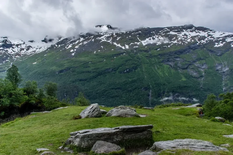
Husfjellet is a masterclass in Arctic topography. Located on the northwestern coast of Senja, the trail serves as a gateway to some of the most photographed landscapes in Scandinavia. Unlike many of the more vertical "scrambles" found in the region, Husfjellet follows a relatively well-defined path that transitions through three distinct ecological zones: the lush, sheltered birch forests of the lower slopes, the marshy alpine plateaus of Sommardalen, and finally, the exposed, wind-swept granite ridges that lead to the summit. This progression provides hikers with a sense of journey and discovery, as the views are gradually revealed rather than being immediate.
The landscape here is defined by the Caledonian orogeny, a mountain-building event that occurred hundreds of millions of years ago. The result is a series of sharp, serrated ridges and deep, U-shaped glacial valleys that have been carved by successive ice ages. From the summit of Husfjellet, the scale of this geological history is laid bare. To the north, the Steinfjord and Ersfjord cut deep into the land, separated by the razor-sharp ridge of Okshornan—famously known as the "Devil’s Jaw" or "Dragon’s Teeth." To the south and west, the Norwegian Sea stretches toward the horizon, its waters often a startling turquoise near the shore, reminiscent of more tropical latitudes despite being well within the Arctic Circle.
What sets Husfjellet apart from its neighbours is the sheer space at the summit. While peaks like Segla or Hesten offer narrow, precarious standing room, Husfjellet provides a broad, plateau-like summit area. This allows hikers to move around, find different angles for photography, and truly soak in the silence of the Arctic wilderness without feeling crowded. It is a place where the air is sharp with the scent of salt and heather, and where the only sound is the occasional cry of a sea eagle or the wind whistling through the granite cracks. For those seeking the definitive Senja hiking experience, Husfjellet is the undisputed crown jewel.
History and Cultural Context
The island of Senja, often described as "Norway in miniature," has a history deeply intertwined with the sea and the rugged mountains that protect its coastal settlements. For centuries, the villages of Skaland and Bergsfjord, which sit at the base of Husfjellet, were isolated outposts of the Norwegian fishing industry. The mountains were not seen as recreational playgrounds but as formidable barriers and landmarks for mariners. Husfjellet itself served as a vital navigational marker for fishermen returning from the treacherous waters of the Norwegian Sea; its distinctive broad profile was easily recognisable from kilometres offshore, guiding boats safely back to the sheltered harbours of the fjords.
The cultural heritage of the region is also shaped by the Sami people, the indigenous inhabitants of northern Scandinavia. Historically, the plateaus around Husfjellet and the Sommardalen valley were used for seasonal reindeer herding. Even today, it is not uncommon to spot reindeer grazing on the high grasses during the summer months, a living link to a nomadic tradition that has existed for millennia. The name "Husfjellet" literally translates to "The House Mountain," likely a reference to its solid, protective shape that looms over the village of Skaland like a roof.
In more recent history, Skaland became known for its graphite mine, one of the oldest and most productive in the world. The industrial heritage of the village provides a stark contrast to the pristine wilderness of the summit. Walking the Husfjellet trail is, in many ways, a walk through these layers of time—from the ancient geological formations to the traditional fishing culture, the industrial era of mining, and the modern-day appreciation of the Arctic as a premier destination for eco-tourism and mountain sports. The trail was famously visited by Queen Sonja of Norway, an avid hiker, which cemented its reputation as the "Queen’s Trail" and brought international attention to the spectacular beauty of Senja’s outer coast.
Want more background? Read extended notes on history and cultural context → Learn more
Seasonal Highlights and Weather Reality
The hiking season on Husfjellet is dictated by the extreme light cycles of the Arctic. Because Senja is located approximately 350 kilometres north of the Arctic Circle, the environmental conditions change dramatically between the seasons, offering vastly different experiences for the hiker.
Summer (June to August): This is the prime hiking window. From late May until late July, the region experiences the Midnight Sun, where the sun never sets below the horizon. Hiking Husfjellet at 11:00 PM or 1:00 AM is a surreal and highly recommended experience; the landscape is bathed in a soft, golden-pink light that lasts for hours, and the temperatures are often more pleasant for physical exertion than during the midday heat. The flora is at its peak, with Arctic wildflowers and lush green mosses lining the lower sections of the trail.
Autumn (September to October): Many locals consider September to be the best month for Husfjellet. The mosquito population disappears, the air becomes crisp and exceptionally clear, and the landscape transforms into a riot of orange, red, and gold as the birch trees and heather prepare for winter. This is also the beginning of the Northern Lights (Aurora Borealis) season. While you wouldn't want to be on the summit in the pitch black, an evening hike can often be rewarded with a celestial display as you descend toward Skaland.
Winter and Spring (November to May): During this period, Husfjellet becomes a serious winter mountaineering or backcountry skiing objective. The trail is buried under deep snow, and the exposed ridges can be extremely dangerous due to cornices and avalanche risk. The "Polar Night" (where the sun does not rise) lasts from late November to mid-January, meaning any excursion requires powerful headlamps and expert navigation. Only those with significant winter experience, avalanche safety training, and proper equipment (crampons, ice axe, or touring skis) should attempt the peak in these months.
Weather Reality: Regardless of the season, the weather on Senja is notoriously fickle. The island sits directly in the path of the Gulf Stream and North Atlantic weather systems. It is common to experience "four seasons in one day." A phenomenon known as havtåke (sea fog) can roll in from the ocean with incredible speed, reducing visibility to a few metres and dropping the temperature by 10 degrees Celsius in minutes. Always check the local forecast on Yr.no before setting out.
Recommended Itinerary
Husfjellet Route Progression
Phase 1: The Forest Ascent (Trailhead to Sommardalen)
- Distance: 1.5 km
- Elevation gain: 250 m
- Time: 45–60 minutes
- The trail begins behind the Skaland Church (Skaland Kirke). Look for the wooden signpost marking the start of the path.
- The initial section winds through a dense forest of silver birch. The path is well-trodden but can be muddy after rain, with many exposed tree roots.
- The gradient is steady and moderate, allowing for a good warm-up. As you gain height, the canopy thins, offering the first glimpses of the Bergsfjord behind you.
- This section is sheltered from the wind, making it the warmest part of the hike.
Phase 2: The Sommardalen Plateau
- Distance: 1 km
- Elevation: Relatively flat with gentle undulations
- Time: 20–30 minutes
- Emerging from the forest, you reach the Sommardalen plateau. This is a wide, marshy area that feels like a hidden hanging valley.
- Wooden planks (spångar) have been laid over the wettest sections to protect the fragile bog ecosystem and keep your boots dry.
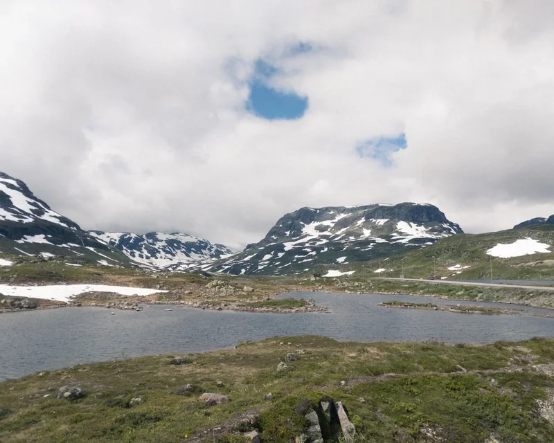
- This is an excellent spot for a short break. To your left, the ridge of Husfjellet begins to loom large. To your right, you can see the path leading toward the lower viewpoint of Sommardalshaugen.
- The views of the Steinfjord start to open up here, providing a taste of the drama to come.
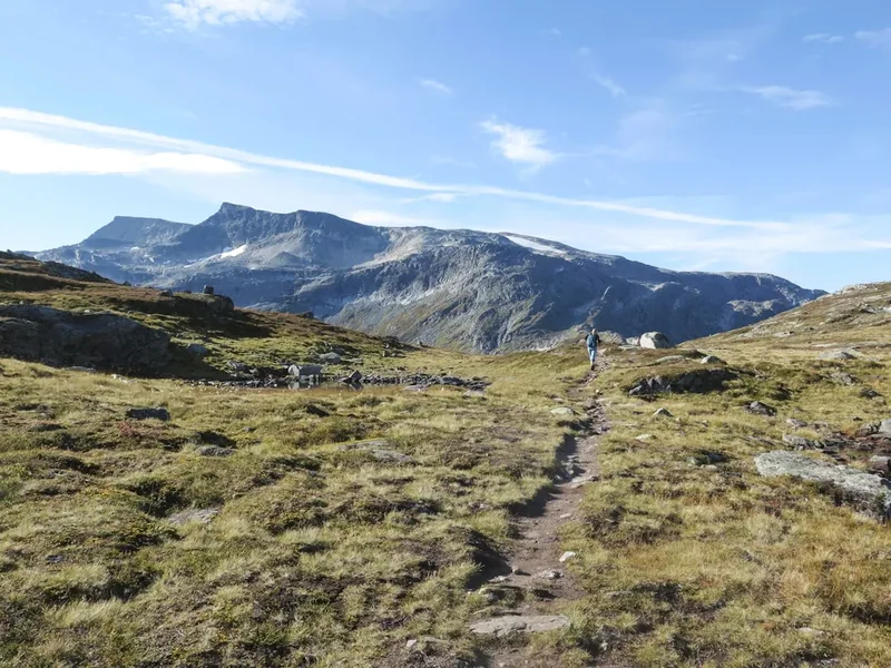
Phase 3: The Ridge Climb
- Distance: 1.2 km
- Elevation gain: 300 m
- Time: 45–75 minutes
- From the plateau, the trail turns sharply upward. This is the most physically demanding part of the hike.
- The path follows the broad spine of the mountain. The terrain changes from grass and mud to rock and scree.
- While the ridge is wide and safe, the drops to the north (toward the Steinfjord) become increasingly sheer. Stay on the marked path to avoid the unstable edges.
- As you climb, the "Dragon’s Teeth" (Okshornan) come into full view across the fjord. The perspective changes with every metre of elevation, making it hard to keep your eyes on the trail.
Phase 4: The Summit Plateau and Viewpoint
- Distance: 0.8 km
- Elevation gain: 82 m
- Time: 20–30 minutes
- The final approach to the summit is a gentle traverse across a rocky plateau. The "true" summit is marked by a large stone cairn (varden).
- Continue past the cairn to the very edge of the seaward cliffs for the most spectacular views. Here, you are suspended 632 metres directly above the Atlantic.
- The 360-degree panorama includes the Ersfjord, the village of Senjahopen, the peak of Segla in the distance, and the endless horizon of the Norwegian Sea.
- Spend at least 30–60 minutes here if the weather allows. The scale of the landscape is difficult to process quickly.
- Return via the same route. The descent is much faster but requires care on the slippery forest sections.
Important Notes:
- The trail is marked with red "T"s on rocks or wooden stakes, though the path is generally obvious.
- There are no water sources on the upper half of the mountain; fill bottles at the streams in the lower forest.
- The summit is highly exposed to wind; even on a warm day in Skaland, it can be freezing at the top.
- Total moving time is usually around 3 hours, but allow 5 hours to include photography and rest stops.
Planning and Bookings
Book Your Trip
Everything you need to plan your journey
Accommodation
Find places to stay near Tromsø
Flights
Search flights to Tromsø
Essential Preparation
Husfjellet is a relatively accessible hike, but its location on the outer coast of Senja requires some logistical planning. Most visitors use Tromsø as their primary gateway. From Tromsø, you have two main options: a long drive via the mainland bridges (approx. 4 hours) or a more scenic route involving the ferry from Brensholmen to Botnhamn (approx. 3 hours total). The ferry is highly recommended as it cuts significant driving time and offers beautiful views of the Kvaløya coastline. Note that the ferry can have long queues in July; arrive at least 45 minutes before departure.
Fitness requirements are moderate. If you can walk for 4–5 hours with a steady incline, you can complete Husfjellet. There is no technical climbing or "scrambling" required, though the final ridge has some exposure that might unnerve those with a severe fear of heights. Ensure you have downloaded offline maps (such as UT.no or Norgeskart), as mobile signal can be intermittent in the deep fjords, though it is generally excellent on the summit itself.
Trail Accommodation
This is a day hike requiring no overnight accommodation on the trail itself. Camping is permitted on the mountain under the Norwegian Allemannsretten (Right to Roam), but finding a flat, non-marshy spot can be challenging. Most hikers stay in the surrounding villages.
Local Options:
- Skaland: The closest village. There are a few guesthouses and apartment rentals available. This is the most convenient base.
- Hamn i Senja: A high-end resort located about 15 minutes' drive from the trailhead. It offers hotel rooms, apartments, a restaurant, and hot tubs overlooking the sea.
- Ersfjordstranda: A famous white-sand beach nearby with a dedicated camping area and the "Gold Toilet" (a world-famous architectural service block). Note that camping here is popular and can be crowded in summer.
- Mefjordvær: A traditional fishing village about 30 minutes away with charming fisherman’s cabins (rorbuer) for rent.
Facilities: There are no toilets, shelters, or rubbish bins on the Husfjellet trail. The nearest public toilets and grocery stores are in Skaland. Ensure you use the facilities before starting your hike.
Required Gear
- Hiking Boots: Waterproof boots with good ankle support are essential. The lower sections are often boggy, and the upper sections are rocky. Trail runners are acceptable in dry conditions but not recommended after rain.
- Layered Clothing: A moisture-wicking base layer (merino wool is best), a warm mid-layer (fleece or light down), and a windproof/waterproof outer shell.
- Trousers: Quick-drying hiking trousers. Avoid jeans, which become heavy and cold when wet.
- Backpack: A 20–30 litre daypack with a rain cover.
- Navigation: A fully charged smartphone with offline maps and a power bank. A physical map and compass are recommended as backups.
- Sun Protection: Sunglasses and sunscreen. The Arctic sun is surprisingly strong, especially when reflecting off the sea and granite.
What to Bring
- Water: At least 1.5–2 litres per person. While there are streams in the forest, the upper mountain is dry.
- Food: High-energy snacks (nuts, chocolate, dried fruit) and a substantial lunch to enjoy at the summit.
- Hot Drink: A thermos of coffee or tea is a Norwegian hiking tradition and very welcome at the wind-swept summit.
- First Aid: A basic kit including blister plasters (Compeed), antiseptic wipes, and a triangular bandage.
- Emergency Whistle: Often built into the chest strap of modern backpacks.
- Trash Bag: To carry out all your waste, including fruit peels and tissues.
Permits
One of the greatest joys of hiking in Norway is the lack of red tape. No permits, fees, or registrations are required to hike Husfjellet. Access is protected by the Friluftsloven (Outdoor Recreation Act), which grants everyone the right to access the countryside, regardless of land ownership.
Key Principles of Access:
- Right to Roam: You can walk anywhere in the "outfield" (uncultivated land) as long as you show respect for nature and landowners.
- Camping: You can pitch a tent for up to two nights in the same spot, provided you are at least 150 metres away from the nearest inhabited house or cabin.
- Parking: There is a designated parking area near the Skaland Church. It is currently free of charge, but this may change as tourism increases. Ensure you do not block local driveways or emergency access roads.
- Organised Groups: If you are leading a large commercial group (10+ people), it is polite to notify the local municipality, though not legally required for a day hike.
While no permit is needed, you are expected to follow the "Norwegian Mountain Code" (Fjellvettreglene), which emphasises self-reliance and safety. The rescue services in Norway are professional but should only be called in genuine emergencies. Being unprepared for the weather is not considered a valid reason for rescue.
Other Activities in the Area
Senja is an island that rewards those who take their time. Beyond Husfjellet, the "Outer Coast" (Yttersida) offers a wealth of experiences:
- The National Scenic Route: Drive the 102-kilometre stretch of road between Gryllefjord and Botnhamn. It is one of Norway’s 18 designated scenic routes, featuring architectural viewpoints like Tungeneset and Bergsbotn.
- Tungeneset Viewpoint: A wooden walkway over the rocks that provides the iconic view of the "Devil’s Jaw" peaks across the water. It is the best place for sunset photography.
- Ersfjordstranda: Visit the white sand beach and see the famous "Gold Toilet." The beach is surrounded by towering peaks and is a popular spot for a (very cold) Arctic swim.
- Sea Kayaking: The Bergsfjord is dotted with dozens of small white-sand islands. Guided kayaking tours from Hamn i Senja allow you to explore these "Arctic Caribbean" waters.
- Fishing: Senja is world-famous for its deep-sea fishing. You can join a charter boat from Mefjordvær or Skaland to catch cod, halibut, and pollock.
- Wildlife Safaris: Boat tours operate out of Andenes (accessible via summer ferry from Gryllefjord) for whale watching, or local tours for sea eagle spotting.
Safety and Conditions
Pre-Departure Checks:
- Check the weather forecast on Yr.no specifically for "Husfjellet." Do not rely on the general forecast for Tromsø.
- Inform someone of your plans and expected return time.
- Ensure your phone is fully charged and you have a backup power source.
- Check for local "Havtåke" (sea fog) warnings. If the peaks are covered in thick, low-lying cloud, the views will be non-existent and navigation becomes difficult.
Terrain Hazards: The Husfjellet trail is not technically difficult, but it has specific hazards. The lower forest section is notoriously slippery when wet; trekking poles are highly recommended for the descent to save your knees and prevent falls. The upper ridge is wide, but the northern face is a vertical drop of several hundred metres. In high winds, stay well away from the edge. Gusts on the summit can be strong enough to knock a person off balance.
The Norwegian Mountain Code (Fjellvettreglene):
- Plan your trip and inform others about the route you have selected.
- Adapt the planned trip according to ability and conditions.
- Pay attention to the weather and avalanche forecasts.
- Be prepared for bad weather and frost, even on short trips.
- Bring the necessary equipment so you can help yourself and others.
- Choose safe routes. Recognise avalanche terrain and unsafe ice.
- Use a map and compass. Always know where you are.
- Don’t be ashamed to turn back.
- Conserve your energy and seek shelter if necessary.
Emergency Contact: In case of a serious accident, dial 112 for the police/rescue coordination centre or 113 for medical emergencies. Note that helicopter rescues are weather-dependent and may not be possible in high winds or thick fog.
Side Trips and Points of Interest
Sommardalshaugen: For those who find the full ascent to Husfjellet too daunting, or for those with extra time, a side trail from the Sommardalen plateau leads to the lower peak of Sommardalshaugen (approx. 300 m). It offers a fantastic view of the Steinfjord with significantly less effort and is a great spot for a picnic if the wind is too high on the main summit.
The "Devil’s Jaw" (Okshornan): While you cannot easily hike to these peaks from Husfjellet, they are the primary visual focus of the summit. These jagged peaks are among the oldest rock formations in Norway, consisting of ancient gneiss that has resisted erosion for millions of years. Seeing them from the height of Husfjellet provides a perspective on their "teeth-like" structure that you cannot get from the road.
Bergsbotn Platform: On your drive back from Skaland toward Senjahopen, stop at the Bergsbotn viewing platform. This 44-metre-long wooden ramp juts out over the mountainside, offering a dizzying view of the Bergsfjord and the village of Skaland where you started your hike. It is a perfect "low-effort, high-reward" stop to complement your day on the mountain.
The Gold Toilet: Located at Ersfjordstranda, this architectural curiosity is worth a quick visit. Clad in gold-coloured aluminium, it is arguably the most famous public toilet in Norway and serves as a testament to the country's investment in making its scenic routes world-class in every detail.
Leave No Trace
The Arctic environment is extremely fragile. The growing season is short, and vegetation that is damaged can take decades to recover. As Husfjellet grows in popularity, it is vital that every hiker adheres to the principles of Leave No Trace to preserve this wilderness for the future.
Specific Guidelines for Husfjellet:
- Stay on the Path: The Sommardalen plateau is particularly susceptible to erosion. Use the provided wooden planks and avoid walking on the sensitive mosses and bogs, which act as vital carbon sinks.
- Waste Management: There are no bins. Pack out every single item of rubbish, including "biodegradable" items like banana skins or orange peels, which do not decompose in the cold Arctic climate and are an eyesore for others.
- Human Waste: If you must go, ensure you are at least 50 metres from any water source or the trail. Bury solid waste in a shallow hole and pack out your toilet paper in a sealed plastic bag.
- Wildlife: Do not disturb the reindeer. If you encounter them, keep your distance and keep dogs on a leash (this is a legal requirement in Norway from April to August).
- Rock Cairns: Do not build new rock cairns. They can mislead other hikers in foggy conditions and disturb the natural aesthetic of the mountain.
- Noise: Respect the silence. Avoid using speakers or shouting; let the sounds of the wind and the sea be the soundtrack to your hike.