Hump Ridge Track - New Zealand's Newest Great Walk
The Hump Ridge Track is a spectacular 61-kilometre loop journey that traverses some of the most diverse and untouched landscapes in the deep south of New Zealand. Located in the rugged Waitutu Forest within Fiordland National Park, this three-day adventure offers a unique blend of sub-alpine wilderness, ancient podocarp rainforest, and dramatic coastal scenery. Recently elevated to "Great Walk" status, the track represents a significant community achievement, having been originally conceived and built by the people of Tuatapere to revitalise their town following the decline of the local timber industry. The route takes walkers from the edge of the Southern Ocean, up onto the limestone tors of the Hump Ridge with panoramic views of Stewart Island and Lake Hauroko, and back down through historic milling sites featuring some of the largest wooden trestle bridges in the Southern Hemisphere. It is a journey through time, ecology, and the sheer resilience of the Southland spirit.
- Distance: 61.0 km loop
- Duration: 3 days / 2 nights
- Season: November–April (Great Walks season; bookings essential)
- Huts: Okaka Lodge and Port Craig Lodge
- Highest point: Okaka Lodge / Hump Ridge (945 m)
- Difficulty: Moderate to Hard (Day 1 involves a significant elevation gain)
- Direction: Clockwise loop starting and finishing at Rarakau Carpark
Overview
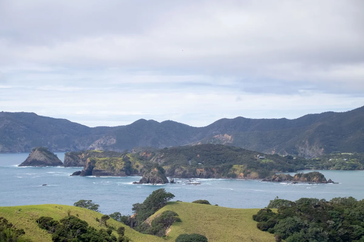
The Hump Ridge Track is often described as a "track of two halves," seamlessly blending the raw power of the sub-alpine environment with the lush, haunting beauty of a coastal rainforest. Unlike many other Great Walks that follow linear valleys or mountain passes, the Hump Ridge is a true loop, providing a constantly changing perspective of the Southland landscape. The journey begins at the Rarakau Carpark, where the air is thick with the scent of salt spray from Te Waewae Bay. From here, the track climbs steadily through varying forest zones—from coastal broadleaf to towering podocarps, and finally into the stunted, moss-draped beech forests of the sub-alpine zone.
The physical challenge of the track is concentrated primarily in the first day, where walkers ascend nearly 900 metres to reach the Okaka Lodge. This climb is rewarded with what many consider the finest views in the South Island. On a clear day, the vista extends across the Foveaux Strait to the jagged peaks of Rakiura/Stewart Island, while to the west, the vast, uninhabited wilderness of Fiordland stretches toward the horizon. The limestone tors that crown the ridge provide a surreal, lunar-like landscape that contrasts sharply with the dense greenery below.
The descent on Day 2 takes walkers back into the heart of the Waitutu Forest, a region of global ecological significance. This is one of the largest remaining areas of unmodified podocarp forest in New Zealand, where Rimu, Miro, and Kahikatea trees have stood for centuries. The track then follows the path of history, utilizing old tramlines and crossing massive wooden viaducts—relics of a bygone era when this forest was the centre of a bustling timber industry. The final day is a long but gentle coastal walk, following the shoreline back to the starting point, allowing walkers to reflect on the immense scale of the terrain they have just conquered. The Hump Ridge Track is not just a walk; it is an immersion into the soul of the deep south.
History and Cultural Context
The history of the Hump Ridge region is a tapestry of Māori heritage, industrial ambition, and community conservation. For Ngāi Tahu, the mana whenua (traditional guardians) of this land, the Waitutu Forest and the surrounding coastline were vital sources of mahinga kai (food gathering). The area provided a wealth of resources, from the sea's bounty to the birds and plants of the forest. The spiritual connection to the land remains strong today, and the track passes through areas that hold deep significance for the local iwi.
In the early 20th century, the region became the site of one of New Zealand's most ambitious industrial undertakings. The Port Craig Timber Company established a massive operation here in the 1920s, aiming to harvest the vast podocarp forests. To transport the timber, an extensive network of tramlines was built, including four enormous wooden viaducts: the Edwin, Lowery, Maurice, and the legendary Percy Burn Viaduct. At 125 metres long and 36 metres high, the Percy Burn remains the largest wooden trestle bridge in the Southern Hemisphere. The settlement at Port Craig was, for a brief time, a thriving town with its own school, post office, and social hall, but the Great Depression and the sheer difficulty of the terrain eventually led to its abandonment in the 1930s. Today, the rusting machinery and the towering viaducts serve as haunting reminders of this industrial past.
The modern Hump Ridge Track was born from a different kind of ambition. In the 1990s, following the closure of the local sawmills, the community of Tuatapere sought a way to reinvent itself. The Tuatapere Hump Ridge Track Trust was formed, and through thousands of hours of volunteer labour and local fundraising, the track was carved out of the wilderness. It opened in 2001 as a private-public partnership, a unique model in New Zealand tramping. Its recent designation as a Great Walk by the Department of Conservation (DOC) is a testament to the track's world-class quality and the enduring dedication of the Tuatapere community.
Want more background? Read extended notes on history and cultural context → Learn more
Seasonal Highlights and Weather Reality
The Hump Ridge Track is located in one of the most weather-exposed regions of New Zealand. The "Roaring Forties"—the powerful westerly winds that circle the Southern Hemisphere—hit this coastline with full force, meaning weather conditions can change with terrifying speed. During the Great Walks season (November to April), the track is at its most accessible, but walkers must still be prepared for four seasons in a single day.
Summer (December to February): This is the most popular time to walk. Days are long, with twilight lasting until nearly 10:00 PM. Temperatures on the coast can be mild (15–20°C), but the ridge can remain chilly and windy. This is also the peak season for sandflies, particularly in the forested and coastal sections. The flora is in full bloom, and the birdlife is most active.
Autumn (March to April): Many experienced trampers prefer this season. The air is often crisper and clearer, providing the best visibility from the Hump Ridge. The sandfly population begins to dwindle, and the forest takes on a golden hue. However, the risk of early autumn storms increases, and temperatures at Okaka Lodge can drop below freezing overnight.
Spring (November): A beautiful but unpredictable time. The forest is lush and vibrant with new growth, and waterfalls are at their most spectacular due to spring rains. Snow can still linger on the higher sections of the ridge, and the track can be particularly muddy in places.
Winter (May to October): Outside the Great Walks season, the track is not managed in the same way. Huts have reduced facilities, and the ridge section can be covered in deep snow and ice. Only experienced alpine trampers with appropriate winter gear (ice axes, crampons) and navigation skills should attempt the track during this time. Avalanche risk is a genuine concern on the steeper sections of the Hump.
Recommended Itinerary
3-Day Hump Ridge Track Itinerary
Day 1: Rarakau Carpark to Okaka Lodge
- Distance: 19 km
- Elevation gain: 900 m
- Time: 7–9 hours
- Start at the Rarakau Carpark, following the coastal track across Bluecliffs Beach
- Cross the Waikoau River via a swing bridge
- Enter the Waitutu Forest and begin the long, steady climb up the Hump Ridge
- Pass through the "Stag Point" viewpoint for your first glimpse of Te Waewae Bay
- The forest transitions from podocarp to silver beech as you gain altitude
- Navigate the limestone tors and boardwalks near the summit
- Arrive at Okaka Lodge (945 m), the highest point on the track
- Enjoy sunset views over Stewart Island and the Southern Ocean
- This is the most physically demanding day of the trek due to the sustained elevation gain
Day 2: Okaka Lodge to Port Craig Lodge
- Distance: 21 km
- Elevation loss: 900 m
- Time: 7–9 hours
- Begin with a descent from the ridge back into the ancient podocarp forest
- Follow the historic tramlines used by the Port Craig Timber Company
- Cross the Edwin Burn Viaduct (the first of the major trestle bridges)
- Cross the Lowery Viaduct
- Cross the magnificent Percy Burn Viaduct (36 m high, 125 m long)
- Cross the Maurice Viaduct
- The track is relatively flat once you reach the tramlines, but the distance is significant
- Arrive at Port Craig Lodge, located near the site of the historic milling town
- Explore the relics of the old town, including the schoolhouse and wharf remains
- Look for Hector's dolphins often seen playing in the surf at Port Craig
Day 3: Port Craig Lodge to Rarakau Carpark
- Distance: 21 km
- Elevation: Mostly flat with minor coastal undulations
- Time: 5–7 hours
- Follow the coastal track through lush broadleaf forest
- Pass through the Blowholes section, where the sea crashes against the rocky shore
- Walk along the pristine sands of Blowholes Beach and Bluecliffs Beach
- The track follows the terrace above the beach for much of the day, offering constant ocean views
- Cross the Waikoau River once more
- Final stretch back to the Rarakau Carpark
- This day is long in distance but easy underfoot, providing a gentle conclusion to the journey
Important Notes:
- The track is a loop and is traditionally walked in a clockwise direction
- Bookings are mandatory for both lodges/huts during the Great Walks season
- Water is available at the lodges, but treatment is recommended
- The climb on Day 1 is steep and requires a good level of cardiovascular fitness
- The viaducts are historic structures; follow all safety signage when crossing
- Pack for all weather conditions, as the ridge is extremely exposed
Planning and Bookings
Book Your Trip
Everything you need to plan your journey
Accommodation
Find places to stay near Tuatapere
Flights
Search flights to Tuatapere
Essential Preparation
Planning for the Hump Ridge Track requires careful coordination, particularly regarding transport and fitness. The track is located in a remote corner of Southland, and the nearest service town is Tuatapere. Most walkers choose to base themselves in Tuatapere the night before starting to ensure an early departure. The Rarakau Carpark is approximately a 30-minute drive from the town centre along a sealed road.
Fitness is a critical component of preparation. While the track is well-maintained, the 900-metre ascent on Day 1 is a significant undertaking, especially with a multi-day pack. Walkers should be comfortable hiking for 8-9 hours on consecutive days. Training on hills and carrying a weighted pack in the weeks leading up to the trip is highly recommended. Additionally, because the track is a loop, you must ensure your vehicle is secure at the carpark or arrange a shuttle service from Tuatapere.
Trail Accommodation
The Hump Ridge Track features two main lodges: Okaka Lodge and Port Craig Lodge. Following its upgrade to a Great Walk, these facilities are managed through a partnership between the Department of Conservation and the Hump Ridge Track Trust. There are options for both "Independent" walkers (staying in bunkrooms) and "Premium" walkers (staying in private rooms with additional amenities).
Hut/Lodge Facilities:
- Bunk beds with mattresses in communal rooms
- Large communal kitchens with gas hobs and basic cooking utensils
- Dining areas with tables and seating
- Flush toilets and solar-powered lighting
- Drying rooms for wet gear (essential in this climate)
- Rainwater collection tanks (boiling or treatment recommended)
- Resident wardens/hosts during the Great Walks season
- Small shop at the lodges selling basic snacks and refreshments
What is NOT Provided:
- Sleeping bags and pillows (must be carried by independent walkers)
- Personal food and meals (unless on a fully guided/catered package)
- Showers (available for premium walkers only; independent walkers have basic wash basins)
- Electricity for charging devices (limited solar power only)
- Rubbish disposal (you must pack out all your own waste)
Booking Requirements:
- Bookings must be made via the official Hump Ridge Track website or the DOC booking system
- The season runs from November to April; spots fill up months in advance
- Costs vary depending on the level of service (Independent vs. Premium)
- Camping is not permitted on the track to protect the fragile environment
Required Gear
- Tramping boots: Sturdy, waterproof boots with good ankle support are essential for the muddy sections and the rocky ridge
- Waterproof jacket: A high-quality, seam-sealed waterproof shell (Gore-Tex or similar) is non-negotiable
- Waterproof overtrousers: Essential for the frequent rain and wind on the ridge
- Warm layers: Merino or synthetic base layers, a fleece or down mid-layer, and a warm hat and gloves
- Tramping pack: 40-60L capacity with a waterproof liner or rain cover
- Sleeping bag: A 3-season sleeping bag (rated to 0°C or lower)
- Head torch: With spare batteries for use in the lodges
- First aid kit: Including blister pads, antiseptic, bandages, and personal medications
- Emergency whistle and survival blanket
What to Bring
- Food: Lightweight, high-energy meals for 3 days (dehydrated meals, porridge, nuts, chocolate)
- Water treatment: Purification tablets or a lightweight filter
- Personal toiletries: Biodegradable soap, toothbrush, toothpaste, and a small travel towel
- Sun protection: SPF 50+ sunscreen, sunglasses, and a sun hat (the alpine sun is fierce)
- Insect repellent: Strong DEET-based repellent for the notorious Southland sandflies
- Rubbish bags: To pack out all waste, including food scraps
- Navigation: A physical map and compass, or a reliable GPS/offline map app
- Power bank: To keep phones/cameras charged for photos
Permits
To walk the Hump Ridge Track during the Great Walks season, you must have a confirmed booking for both Okaka and Port Craig lodges. There is no separate "permit" required beyond your lodge reservation, which serves as your authorisation to be on the track. The booking system is managed by the Tuatapere Hump Ridge Track Trust in conjunction with the Department of Conservation.
Booking Process:
- Reservations typically open in May or June for the following summer season (November–April)
- Bookings are made online through the official Hump Ridge Track website
- You must select your start date and choose between "Independent" or "Premium" packages
- Full payment is required at the time of booking to secure your spot
- Cancellations and date changes are subject to specific fees and notice periods
Costs (Approximate):
- Independent Walker: Approximately NZ$250–$350 for the full 3-day circuit (includes lodge stays)
- Premium/Guided Options: Can range from NZ$600 to over NZ$1,500 depending on catering and private room upgrades
- Children: Reduced rates are often available for younger trampers
Check-in Procedures:
- All walkers must check in at the Hump Ridge Track Office in Tuatapere before heading to the trailhead
- During check-in, you will receive your track briefing, weather updates, and lodge vouchers
- This is also the time to arrange any last-minute shuttle transport or bag storage
Other Activities in the Area
The Southland region offers a wealth of additional experiences for those with extra time before or after their hike:
- Waitutu Jet Boat: For a different perspective of the forest, take a jet boat tour up the Wairaurahiri River. This is New Zealand's steepest boat-navigable river, dropping 180 metres over 27 kilometres of Grade 3 rapids.
- Lake Hauroko: Visit the deepest lake in New Zealand (462 metres). It is a place of immense beauty and Māori legend, with several short walks available near the shore.
- Gemstone Beach: Located near Orepuki, this beach is famous for its semi-precious stones (garnet, jasper, quartz) that wash up in the surf. It is a perfect spot for a relaxing stroll.
- Cosy Nook: A picturesque, rocky fishing cove that looks like it belongs in Cornwall. It offers great photography opportunities and a glimpse into the local fishing culture.
- Invercargill: The southernmost city in New Zealand is about 1.5 hours away. Visit Bill Richardson Transport World or the E Hayes and Sons hardware store to see the legendary "World's Fastest Indian" motorcycle.
- Riverton: Known as the "Riviera of the South," this charming seaside town has excellent cafés and a great local museum (Te Hikoi) detailing the region's history.
Safety and Conditions
The Hump Ridge Track is a serious undertaking in a remote environment. Safety must be your primary concern throughout the journey. The most significant risk on this track is the weather. The Hump Ridge is extremely exposed to the wind and rain coming off the Southern Ocean. Hypothermia is a real danger, even in summer, if you are not properly equipped with waterproof and warm layers.
Track Conditions: While the track is a Great Walk and generally well-maintained, it can become very muddy after heavy rain, particularly in the forested sections of Day 2 and Day 3. The boardwalks on the ridge can be slippery when wet or icy. Always watch your footing, especially on the historic viaducts, which can be daunting for those with a fear of heights.
Communication: Cell phone coverage is non-existent for most of the track. There is limited coverage at the summit of the Hump and near Okaka Lodge, but it should not be relied upon. It is highly recommended to carry a Personal Locator Beacon (PLB), which can be hired from the track office in Tuatapere or from outdoor stores in Invercargill.
Water and Food: Ensure you carry enough water for each day's hike. While there is water at the lodges, there are few reliable sources on the climb up the Hump on Day 1. Always carry at least 2 litres of water. Ensure you have enough high-energy food to sustain you through long days of exertion.
Emergency Procedures: In the event of an injury or emergency, stay where you are and use your PLB. If you are at a lodge, notify the warden immediately. The lodges are equipped with radio communications for emergencies. Always fill out the intentions book at each lodge so the wardens know your planned movements.
Side Trips and Points of Interest
The Hump Ridge Track is rich with small detours and landmarks that add depth to the experience:
The Loop Track (Okaka): Near Okaka Lodge, there is a short loop track that takes you through the limestone tors. This is a must-do at sunset or sunrise, providing 360-degree views of the Southern Ocean, Stewart Island, and the Fiordland mountains. The rock formations are ancient and provide excellent shelter from the wind for photography.
Percy Burn Viaduct: While the track crosses this viaduct, it is worth taking the time to walk down to the stream bed below (where permitted) to appreciate the sheer scale of the engineering. Standing beneath the massive wooden pillars gives you a true sense of the industrial effort required to build this structure in the 1920s.
Port Craig Schoolhouse: The original schoolhouse from the milling days has been preserved and now serves as a DOC hut for those not staying in the main lodge. It contains historical displays and photographs that tell the story of the families who lived in this isolated community.
Sand Hill Point: A short detour on Day 3 takes you to Sand Hill Point, where you can see the remains of the old telegraph line and enjoy views of the rugged coastline. It is a wild, wind-swept place that captures the essence of the Southland coast.
The Blowholes: On the final day, the track passes a series of rocky outcrops where the tide is forced through narrow gaps, creating spectacular plumes of spray. This is most impressive during high tide or after a storm.
Leave No Trace
The Waitutu Forest is a pristine and ecologically sensitive environment. As a walker, you have a responsibility to minimise your impact on this landscape. The Hump Ridge Track Trust and DOC work hard to protect this area, and all visitors are expected to follow the Leave No Trace principles.
Key Responsibilities:
- Plan Ahead and Prepare: Ensure you have the right gear and skills to avoid needing rescue, which puts a strain on local resources.
- Travel and Camp on Durable Surfaces: Stay on the formed track and boardwalks at all times. The sub-alpine vegetation on the ridge is extremely fragile and can take decades to recover from being stepped on.
- Dispose of Waste Properly: Pack out everything you pack in. This includes all food scraps (even biodegradable ones like apple cores, which can attract pests) and all personal hygiene products. Use the toilets provided at the lodges.
- Leave What You Find: Do not remove plants, rocks, or historical artefacts from the milling sites. The viaducts and machinery are part of New Zealand's heritage.
- Minimise Campfire Impacts: Fires are strictly prohibited on the track. Use the gas hobs provided at the lodges for cooking.
- Respect Wildlife: Do not feed the birds, especially the Kea and Kaka. Feeding them human food makes them dependent and can lead to dangerous behaviour.
- Be Considerate of Others: Keep noise levels down in the lodges and on the track to allow everyone to enjoy the sounds of the wilderness.