
Huaytapallana Glacier Trek
The Huaytapallana Glacier Trek is a challenging day walk in the heart of the Peruvian Andes, offering breathtaking glacial landscapes and a true taste of high-altitude trekking. Located near the city of Huancayo, this trek ascends towards the imposing Huaytapallana massif, culminating in views of the receding Huaytapallana Glacier and its surrounding glacial lakes. It's a journey that demands physical resilience and rewards with unparalleled alpine vistas, a stark contrast to the lush valleys below. This trek is a testament to the raw power and beauty of glacial environments, providing an accessible yet demanding adventure for those seeking to explore Peru's high mountain terrain.
- Distance: 12.0 km one-way
- Elevation gain: 800 m
- Duration: 6-8 hours
- Difficulty: Challenging
- Best Time: May to September (dry season)
- Closest City: Huancayo
- Trailhead Access: From Huancayo, take a colectivo (shared taxi) or private taxi to the village of Vilcacoto. From Vilcacoto, hire a local guide and transport (4x4 recommended) to the trailhead near Laguna 513. The road is unpaved and can be rough. Driving time approx. 2-3 hours. Limited parking available. No formal permits required, but hiring a guide is strongly recommended.
- Coordinates: -12.0333, -75.2000
Overview
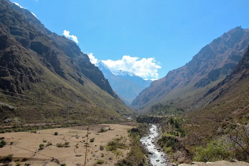
The Huaytapallana Glacier Trek is a significant undertaking, primarily due to its steep elevation gain and the altitude at which it is conducted. The trek begins at a considerable elevation, and the ascent is relentless, pushing walkers towards the snow-capped peaks of the Huaytapallana range. The trail winds through increasingly barren, rocky terrain, offering panoramic views of the surrounding Andean landscape. As you gain altitude, the vegetation thins, giving way to alpine meadows and then to scree slopes and glacial moraines. The air becomes thinner and cooler, a constant reminder of the challenging environment.
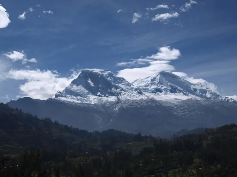
The highlight of the trek is undoubtedly the approach to the Huaytapallana Glacier. While the glacier itself is receding due to climate change, its presence is still awe-inspiring. You will likely encounter glacial lakes, such as Laguna 513, which are often a vibrant turquoise or deep blue, reflecting the surrounding mountains and sky. The sheer scale of the glacial formations, the vastness of the mountain range, and the crisp, clean air create an unforgettable experience. This trek is not for the faint of heart; it requires good physical condition, acclimatisation to altitude, and a respect for the power of nature. The descent can be as challenging as the ascent, requiring careful footing on loose terrain.
The trek is typically undertaken as a day hike, meaning a long and demanding day is involved. The journey to the trailhead itself is an adventure, often requiring a 4x4 vehicle due to the rough, unpaved roads. Hiring a local guide is not only recommended for navigation and safety but also for the invaluable insights they provide into the local culture, geology, and the environmental changes affecting the glacier. The dry season, from May to September, offers the most stable weather conditions, with clear skies and minimal rainfall, making it the ideal time to attempt this challenging yet rewarding trek.
History and Cultural Context
The Huaytapallana mountain range, and the glacier itself, hold significant cultural and spiritual importance for the indigenous communities of the Junín and Huancayo regions. For centuries, these mountains have been revered as sacred Apus (mountain spirits) by the Quechua people. They are considered guardians of the land, sources of water, and vital to the agricultural cycles that sustain local communities. Traditional ceremonies and offerings are often made to these mountain spirits to ensure good harvests, favourable weather, and protection.
The name "Huaytapallana" itself is derived from Quechua, with "Huayta" potentially referring to a type of flower or plant, and "pallana" meaning "to pick" or "to gather." This suggests a historical connection to the gathering of medicinal plants or other resources from the mountain slopes. The presence of glaciers in this region has historically been crucial for providing meltwater for irrigation and drinking water, especially during the dry season. The receding nature of the Huaytapallana Glacier is a visible and poignant reminder of the impacts of climate change on these vital water sources and the traditional ways of life that depend on them.
In more recent history, the Huaytapallana range has become a destination for mountaineers and trekkers drawn by its dramatic landscapes and challenging terrain. While not as internationally renowned as some of Peru's more famous trekking circuits, it offers a more authentic and less crowded experience of the high Andes. The development of tourism in the region, while providing economic opportunities, also brings the challenge of balancing visitor access with the preservation of the fragile environment and the cultural heritage of the local communities. The trek to the glacier is a journey through a landscape that is both geologically spectacular and deeply interwoven with the cultural fabric of the Andean people.
Seasonal Highlights and Weather Reality
The Huaytapallana Glacier Trek is best undertaken during the dry season in the Peruvian Andes, which typically runs from May to September. This period offers the most favourable weather conditions for high-altitude trekking.
Dry Season (May to September): This is the prime trekking season. Days are generally sunny and clear, with minimal rainfall. Temperatures can be cold, especially at night and in the early morning, often dropping below freezing. Daytime temperatures can be pleasant in direct sunlight but can feel cool in the shade or when the wind picks up. The skies are typically a brilliant blue, offering excellent visibility of the surrounding peaks and the glacier. This is the period when the roads to the trailhead are most accessible, although they can still be rough.
Shoulder Seasons (April and October): These months can be transitional. There's a higher chance of encountering some rain or snow showers, but the landscapes can be particularly beautiful with fresh snow dusting the higher peaks. The crowds are also likely to be smaller than during the peak dry season. However, weather can be more unpredictable, and it's essential to check forecasts closely.
Wet Season (November to March): This period is generally not recommended for trekking the Huaytapallana Glacier. Heavy rainfall is common, which can make the unpaved roads to the trailhead impassable, even for 4x4 vehicles. Landslides and rockfalls are more frequent. The trails can become muddy and slippery, and visibility is often poor due to cloud cover and fog. The glaciers and surrounding areas can also be more dangerous due to unstable snowpack and increased avalanche risk.
Weather Reality: Regardless of the season, mountain weather is notoriously unpredictable. Even during the dry season, sudden changes can occur. Expect strong winds, especially at higher elevations, and a significant drop in temperature as soon as the sun sets or if clouds roll in. Altitude sickness is a significant concern, and it's crucial to acclimatise properly before attempting this trek. The thin air, intense sun, and potential for rapid weather shifts mean that preparedness is key.
Recommended Itinerary

Huaytapallana Glacier Trek - Day Hike Itinerary
Early Morning (Approx. 4:00 AM - 5:00 AM): Departure from Huancayo
- Arrange for a taxi or 4x4 transport from Huancayo to Vilcacoto.
- The journey to Vilcacoto typically takes 1-2 hours, depending on road conditions and traffic.
- In Vilcacoto, meet your pre-arranged local guide and secure 4x4 transport to the trailhead.
- The drive from Vilcacoto to the trailhead near Laguna 513 is rough and can take 1-2 hours.
- This early start is crucial to maximise daylight hours and allow ample time for the trek and return journey.
Morning (Approx. 7:00 AM - 8:00 AM): Arrival at Trailhead and Start of Trek
- Arrive at the trailhead, typically located near Laguna 513.
- Brief acclimatisation and final gear check.
- Begin the ascent towards the Huaytapallana Glacier.
- The initial part of the trail may pass through sparse vegetation and rocky terrain.
- Elevation gain is significant from the start.
Late Morning to Midday (Approx. 10:00 AM - 1:00 PM): Ascent and Glacial Views
- Continue climbing, with the landscape becoming increasingly alpine and barren.
- Pass by glacial lakes, such as Laguna 513, which offer stunning reflections and photo opportunities.
- The trail becomes steeper and may involve navigating scree slopes or moraine.
- The Huaytapallana Glacier will become increasingly visible, showcasing its impressive scale and icy formations.
- Take short breaks to hydrate and acclimatise to the altitude.
- Enjoy the panoramic views of the surrounding Andean peaks.
Afternoon (Approx. 1:00 PM - 3:00 PM): Reaching the Glacier/High Point and Lunch
- Reach the closest safe point to the Huaytapallana Glacier or a designated high point offering the best views.
- Enjoy a packed lunch amidst the spectacular glacial scenery.
- Spend time observing the glacier, its crevasses, and the surrounding ice formations.
- Note the signs of glacial retreat and discuss with your guide the environmental changes.
- This is the turnaround point for most day hikers.
Late Afternoon (Approx. 3:00 PM - 6:00 PM): Descent and Return Journey
- Begin the descent back towards the trailhead.
- The descent requires careful footing on loose scree and rocky sections.
- Continue to hydrate and monitor for signs of altitude sickness.
- Arrive back at the trailhead near Laguna 513.
- Meet your waiting 4x4 transport.
- Begin the drive back to Vilcacoto and then to Huancayo.
Evening (Approx. 7:00 PM onwards): Arrival in Huancayo
- Arrive back in Huancayo, tired but exhilarated from the day's adventure.
- Celebrate your accomplishment with a well-deserved meal.
Important Notes:
- This is a challenging day hike requiring excellent physical fitness and acclimatisation to altitude.
- Hiring a local guide is strongly recommended for safety, navigation, and cultural insights.
- 4x4 transport is essential for reaching the trailhead from Vilcacoto.
- Carry plenty of water and high-energy snacks.
- Be prepared for rapidly changing mountain weather.
- Start the trek as early as possible to allow ample time.
Planning and Bookings
Book Your Trip
Everything you need to plan your journey
Accommodation
Find places to stay near Huancayo
Flights
Search flights to Huancayo
Essential Preparation
The Huaytapallana Glacier Trek is a demanding day hike that requires careful planning, especially concerning altitude and logistics. Huancayo is the primary base city, offering a range of accommodation options from budget hostels to mid-range hotels. It's essential to spend at least 2-3 days in Huancayo (or a similar altitude location like Jauja) to acclimatise before attempting the trek. This acclimatisation period is crucial for preventing altitude sickness, which can severely impact your enjoyment and safety. Arrange your transport to the trailhead well in advance. This typically involves a taxi from Huancayo to Vilcacoto, followed by a pre-booked 4x4 vehicle and a local guide from Vilcacoto to the starting point near Laguna 513. The road conditions are often poor, making the 4x4 essential.
Trail Accommodation
This is a day hike requiring no overnight accommodation.
Required Gear
- Sturdy hiking boots: Waterproof and well broken-in, with good ankle support for rocky and uneven terrain.
- Backpack: A daypack (20-30 litres) is sufficient, with a rain cover.
- Layered clothing: Essential for adapting to changing temperatures. Include a moisture-wicking base layer, an insulating mid-layer (fleece or down jacket), and a waterproof and windproof outer shell.
- Warm hat and gloves: Even in the dry season, temperatures can drop significantly at altitude.
- Sun protection: High SPF sunscreen, sunglasses, and a wide-brimmed hat are vital due to the intense sun at high altitudes.
- Head torch: With spare batteries, in case of an early start or late finish.
- First-aid kit: Including blister treatment, pain relievers, antiseptic wipes, and any personal medications.
- Trekking poles: Highly recommended for stability on ascents and descents, especially on scree.
- Navigation: While a guide is recommended, a GPS device or offline map app on your phone can be a useful backup.
What to Bring
- Water: At least 2-3 litres per person. Consider a hydration reservoir or water bottles.
- Water purification: A filter or purification tablets are advisable, although water sources may be scarce at higher elevations.
- Food: High-energy snacks and a packed lunch. Examples include nuts, dried fruit, energy bars, sandwiches, and chocolate.
- Camera: To capture the stunning glacial landscapes.
- Personal items: Toiletries (biodegradable soap, toothbrush, toothpaste), hand sanitiser, and any personal comfort items.
- Identification and emergency contact information.
- Cash: For local transport, guides, and any small purchases.
Permits
Currently, there are no formal permits required for day hikers to access the Huaytapallana Glacier area. However, it is strongly recommended to hire a local guide. Guides are essential for navigating the terrain, understanding the local environment, and ensuring your safety, especially given the altitude and potential for rapid weather changes. They can also assist with arranging the necessary 4x4 transport from Vilcacoto to the trailhead, which is often a prerequisite for accessing the starting point of the trek.
When arranging your trek, it is advisable to confirm with your guide or tour operator about any local community fees or contributions that may be expected, particularly if you are trekking through areas that are important to local indigenous communities. These contributions help support the local economy and the preservation of the natural environment.
Key Considerations:
- Guide Recommendation: While not strictly mandatory, hiring a local guide is highly recommended for safety, navigation, and cultural insights.
- Transport: 4x4 transport from Vilcacoto to the trailhead is often necessary and should be arranged in advance.
- Community Fees: Inquire about any potential local community fees or contributions.
- Environmental Respect: Always practice Leave No Trace principles to preserve the fragile alpine environment.
Other Activities in the Area
While the Huaytapallana Glacier Trek is a significant undertaking, the region around Huancayo offers several other attractions and activities for visitors:
- Laguna 513: This stunning glacial lake is often the starting point or a key landmark on the trek. It's a beautiful spot for photography and enjoying the alpine scenery, even if you don't complete the full glacier trek.
- Huancayo City Exploration: Huancayo itself is a vibrant city with a rich cultural heritage. Visit the Mercado Modelo (Central Market) for local crafts, textiles, and produce. Explore the Plaza de la Constitución and the Cathedral.
- Inca Bridge (Q'eswachaka): Although a significant drive from Huancayo, the Q'eswachaka is the last remaining Inca rope bridge, meticulously maintained by local communities using traditional methods. It's a fascinating cultural experience.
- San Jerónimo de Tunán: A town known for its silversmiths, where you can purchase intricate silver jewellery and handicrafts.
- Pariamarca Archaeological Site: Explore ancient Wanka ruins that offer insights into the pre-Inca history of the region.
- Valle del Mantaro (Mantaro Valley): This fertile valley is the agricultural heartland of the region, dotted with traditional villages, farms, and stunning landscapes. You can explore local crafts, pottery, and agricultural practices.
- Thermal Baths: Several natural hot springs are located in the vicinity of Huancayo, offering a relaxing way to unwind after a day of trekking.
Safety and Conditions
Altitude Sickness (Soroche): This is the primary safety concern. Huancayo is already at a high altitude (approx. 3,271 m), and the trek ascends much higher. Symptoms include headache, nausea, dizziness, and fatigue. Acclimatise properly in Huancayo for 2-3 days before the trek. Ascend slowly, stay hydrated, avoid alcohol and heavy meals, and consider medication like Diamox (consult your doctor). If symptoms worsen, descend immediately.
Weather: Mountain weather can change rapidly. Be prepared for strong winds, sudden temperature drops, and potential precipitation (rain or snow), even during the dry season. Always check the forecast before you go and carry appropriate layered clothing.
Terrain: The trail is challenging, involving steep ascents, loose scree, and rocky sections. Trekking poles are highly recommended for stability. Wear sturdy, broken-in hiking boots.
Navigation: While hiring a guide is strongly advised, ensure you have a reliable map or GPS device as a backup. Trails can be indistinct in places, especially at higher altitudes.
Water: Carry ample water. While streams may be present, water sources at higher elevations can be scarce or contaminated. Use a water filter or purification tablets if you plan to refill.
Transport: The roads to the trailhead are rough and often require a 4x4 vehicle. Ensure your transport is reliable and that your driver is experienced with these conditions.
Communication: Mobile phone signal is likely to be non-existent for most of the trek. Inform someone of your plans, including your expected return time.
Emergency: Carry a well-stocked first-aid kit. In case of a serious emergency, evacuation may be difficult and time-consuming. Your guide will be your primary resource for emergency procedures.
Glacier Safety: Do not attempt to walk on the glacier itself without specialised equipment and expertise. Crevasses can be hidden and dangerous. Stay at a safe distance from the glacier's edge.
Side Trips and Points of Interest
Laguna 513: This is a primary point of interest and often the starting point for the ascent towards the glacier. The lake's vibrant turquoise waters, set against the stark mountain landscape, make it a photographer's dream. It's a perfect spot for a break and to acclimatise before the main ascent.
Huaytapallana Glacier Viewpoints: As you ascend, numerous vantage points offer increasingly spectacular views of the glacier. The trek aims to reach a safe viewpoint close to the glacier's terminus, allowing you to appreciate its scale, ice formations, and the surrounding glacial moraines. Observing the extent of glacial retreat here provides a powerful environmental message.
Alpine Meadows and Rock Formations: The trek passes through diverse alpine environments. You'll encounter hardy alpine flora in the lower sections and dramatic, rugged rock formations as you gain altitude. The stark beauty of the high Andes is a constant companion.
Panoramic Andean Vistas: The higher you climb, the more expansive the views become. On a clear day, you can see for miles across the vast Andean mountain ranges, with snow-capped peaks stretching towards the horizon. These vistas are a significant reward for the strenuous effort.
Potential for Wildlife: While not guaranteed, keep an eye out for high-altitude wildlife such as vicuñas (wild relatives of llamas and alpacas), condors soaring overhead, or various species of Andean birds. Your guide may be able to point out local fauna.
Leave No Trace
The Huaytapallana Glacier Trek traverses a fragile alpine environment that is vital to the local ecosystem and holds cultural significance. Adhering to Leave No Trace principles is paramount to preserving this landscape for future generations and respecting the local communities.
- Plan Ahead and Prepare: Research the trek, understand the conditions, and arrange for a guide and appropriate transport. Acclimatise properly to prevent altitude sickness.
- Travel and Camp on Durable Surfaces: Stick to established trails where they exist. Avoid walking on fragile alpine vegetation, which can take years to recover.
- Dispose of Waste Properly: Pack out everything you pack in, including all food scraps, wrappers, and any other litter. Use designated toilet facilities if available, or dig a cathole at least 60 metres away from water sources, trails, and campsites. Pack out all toilet paper.
- Leave What You Find: Do not remove rocks, plants, or any natural or cultural artifacts. Take only photographs and memories.
- Minimise Campfire Impacts: Campfires are generally not feasible or appropriate for this high-altitude day trek. If camping were an option, use established fire rings and keep fires small.
- Respect Wildlife: Observe wildlife from a distance. Do not feed animals, as it can disrupt their natural behaviours and diets.
- Be Considerate of Other Visitors: Keep noise levels down and yield to other hikers on the trail. Respect the cultural significance of the mountains to local communities.
By following these principles, you help ensure that the beauty and integrity of the Huaytapallana Glacier remain intact.