High Tatras Trail (Tatranská Magistrála) - The Crown of the Carpathians
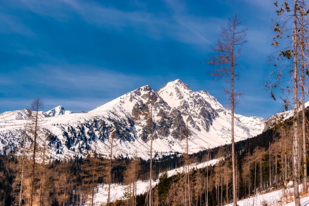
The High Tatras Trail, known locally as the Tatranská Magistrála, is the premier long-distance trekking route in Slovakia, traversing the southern slopes of the highest mountain range in the Carpathian arc. Stretching approximately 70 kilometres from the western reaches of the range at Štrbské Pleso to the eastern edges in the Belianske Tatras, this trail offers an unparalleled alpine experience in what is often described as the "smallest high-mountain range in the world." The route is a masterclass in glacial geography, weaving through jagged granite peaks, deep U-shaped valleys, and over 100 shimmering alpine lakes known as "plesá." Unlike many European alpine routes that rely on cable cars and heavy infrastructure, the High Tatras Trail maintains a rugged, authentic character where supplies are still frequently carried to mountain huts on the backs of legendary porters. This is a journey through a UNESCO Biosphere Reserve, where the air is thin, the granite is ancient, and the landscape demands both physical stamina and deep respect for the volatile mountain weather.
- Distance: 70.0 km point-to-point
- Duration: 5–7 days
- Season: Mid-June to October (strict seasonal closures apply to high-altitude sections)
- Accommodation: Mountain huts (Chaty) and mountain hotels
- Highest point: Sedlo pod Svišťovkou (2,023 m)
- Total Elevation Gain: 4,500 m
- Difficulty: Challenging (requires high fitness and comfort with rocky, technical terrain)
- Direction: Typically walked West to East (Štrbské Pleso to Tatranská Kotlina)
Overview
The High Tatras Trail is not merely a walk; it is a traverse of a geological masterpiece. The High Tatras (Vysoké Tatry) occupy a compact area of only 260 square kilometres, yet they pack the dramatic intensity of the Alps into a much smaller footprint. The Magistrála serves as the arterial route of this range, staying mostly between 1,200 and 2,000 metres in elevation. It provides a continuous link between the range's most iconic valleys, offering hikers a front-row seat to the dramatic transition from dense spruce forests to the dwarf pine zone (kosodrevina) and finally into the stark, wind-swept world of granite scree and alpine meadows.
The terrain is famously demanding. The trail is largely constructed of "granite pavement"—large, hand-placed stones that have formed the path for decades. While this provides a stable surface, it is exceptionally hard on the knees and ankles, requiring sturdy footwear and a steady pace. The ascent to passes like Ostrva or Svišťovka involves steep switchbacks that test the lungs, but the reward is always a panoramic view of the Slovak plains to the south and the jagged, snow-dusted peaks of the "Inner Tatras" to the north. The presence of the Tatra chamois (a unique subspecies of mountain goat) and the Tatra marmot adds a layer of wildness to the experience, as these animals are frequently spotted near the higher passes.
Culturally, the trail is defined by the "Chata" (mountain hut) culture. These are not merely hostels; they are sanctuaries of Slovak mountain tradition. Each hut has its own personality, from the bustling Hrebienok hub to the secluded Chata pri Zelenom Plese, nestled beside a turquoise lake under the towering north face of Malý Kežmarský štít. The logistics of the trail are supported by the town of Poprad, located in the valley below, which serves as the gateway to the range via the "Tatra Electric Railway," a charming narrow-gauge train that connects the various trailhead villages. For those seeking a concentrated dose of alpine drama, the High Tatras Trail is arguably the most rewarding multi-day trek in Central Europe.
History and Cultural Context
The history of the High Tatras Trail is inextricably linked with the birth of European nature conservation. In 1949, the Tatra National Park (TANAP) was established as the first national park in the former Czechoslovakia, and it remains the oldest in modern-day Slovakia. The trail itself, the Magistrála, was conceived and constructed in the 1930s by the Club of Czechoslovak Tourists to create a unified route across the range, connecting existing paths and huts into a single, cohesive journey. This era of trail building was a monumental feat of manual labour, as thousands of granite blocks were moved by hand to create the "pavement" that hikers still walk on today.
A unique and vital part of the trail's cultural heritage is the tradition of the "Horskí nosiči" (mountain porters). Because many of the huts are inaccessible by road, supplies—including food, kegs of beer, and gas canisters—are carried up the steep trails on wooden pack frames. These porters often carry loads exceeding 60 to 80 kilograms, and in some cases, over 100 kilograms. This tradition is so revered that an annual race, the "Sherpa Rallye," is held on these trails. Hikers will frequently encounter these porters on the Magistrála; it is customary to step aside and give them the right of way, as their physical exertion is immense. The huts they supply are the lifeblood of the trail, serving traditional Slovak mountain fare like "Kapustnica" (sauerkraut soup) and "Parené buchty" (steamed jam buns) to weary travellers.
The region also holds deep significance for the local Goral people, highlanders who have lived in the shadow of the Tatras for centuries. Their unique dialect, music, and architecture (particularly in the village of Ždiar at the trail's end) reflect a life shaped by the harsh mountain environment. During the Second World War, these mountains served as a stronghold for partisans resisting occupation, and several monuments along the trail commemorate the bravery of those who fought in the Slovak National Uprising. Today, the High Tatras are a symbol of Slovak national pride, appearing on the national coat of arms and in the national anthem.
Want more background? Read extended notes on history and cultural context → Learn more
Seasonal Highlights and Weather Reality
The High Tatras are a high-altitude environment where winter holds a firm grip for much of the year. Consequently, the hiking season is strictly defined by both weather and park regulations. From 1 November to 14 June, all high-altitude trails and passes are closed to protect the wildlife and ensure hiker safety during the heavy snow season. Attempting the Magistrála during this time is not only illegal but extremely dangerous due to high avalanche risk.
Summer (July and August): This is the peak season. The weather is at its most stable, though afternoon thunderstorms are a frequent and serious hazard. Temperatures in the valleys can reach 25°C, but on the passes, it can drop to 5°C even in midday. This is the best time for spotting chamois and marmots, and all mountain huts are fully operational. However, the trail can be crowded, especially near the hubs of Štrbské Pleso and Hrebienok.
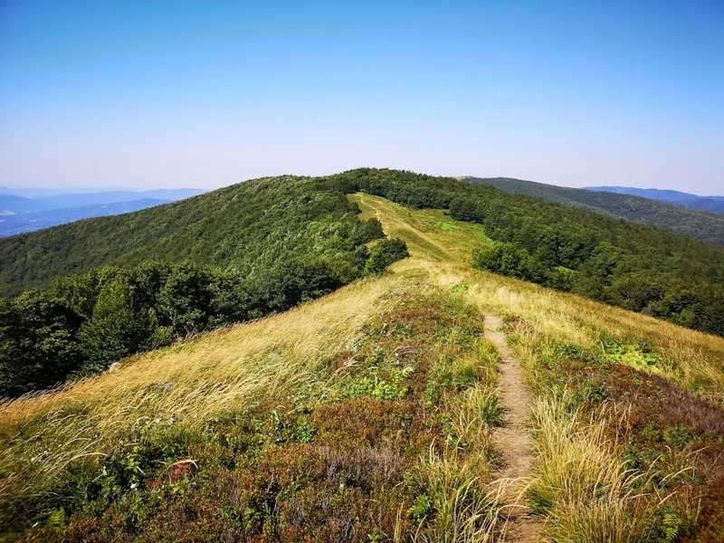
Autumn (September to October): Many experienced hikers consider this the "golden window." The air is crisp and exceptionally clear, providing the best visibility for photography. The crowds of summer dissipate, and the dwarf pines and larch trees begin to turn shades of gold and orange. While the days are shorter and the mornings are frosty, the stability of the weather is often superior to the stormy summer months. Be prepared for the first dustings of snow on the peaks in late September.
Spring (Late June): When the trails first open in mid-June, significant snow patches often remain on the northern slopes and in the high passes (especially Sedlo pod Svišťovkou). Hikers during this period should be comfortable crossing hard-packed snow and may require micro-spikes. The waterfalls are at their most thunderous during the spring melt, and the alpine meadows erupt with wildflowers, including the rare edelweiss and various species of gentian.
Recommended Itinerary
5-Day High Tatras Magistrála Itinerary
Day 1: Štrbské Pleso to Popradské Pleso
- Distance: 5.5 km
- Elevation gain: 250 m
- Time: 1.5–2 hours
- Start at the iconic glacial lake of Štrbské Pleso (1,346 m)
- Follow the red-marked Magistrála trail through a mix of forest and open slopes
- Gentle ascent with views back toward the Low Tatras in the distance
- Arrive at Popradské Pleso, a stunning lake surrounded by the peaks of Mengusovská dolina
- Stay at Horsky Hotel Popradské Pleso or the more rustic Majláthova Chata
- Optional: Visit the Symbolic Cemetery (Symbolický cintorín) nearby, a moving memorial to those who lost their lives in the Tatras
Day 2: Popradské Pleso to Sliezsky Dom
- Distance: 11 km
- Elevation gain: 850 m
- Time: 4.5–5.5 hours
- The first major challenge: a steep, zig-zagging ascent to the Ostrva Pass (1,966 m)
- Breathtaking views from the pass over the Popradské Pleso valley
- Traverse the high-altitude slopes of Končistá and Gerlachovský štít (the highest peak in the range)
- Pass the Batizovské Pleso, a serene lake reflecting the granite walls above
- Descent to Sliezsky Dom (1,670 m), the highest mountain hotel in Slovakia, located at the base of Velická dolina
- The terrain is predominantly the classic "granite pavement," requiring careful footwork
Day 3: Sliezsky Dom to Zamkovského Chata
- Distance: 13 km
- Elevation gain: 400 m
- Time: 5–6 hours
- Descend through the Velická dolina, passing the "Eternal Rain" waterfall
- Traverse toward Hrebienok, a major tourist hub accessible by funicular from Starý Smokovec
- Pass the Obrovský vodopád (Giant Waterfall) and the historic Rainerova Chata (the oldest hut in the Tatras)
- Continue to Zamkovského Chata (1,475 m), nestled in the forest at the mouth of Malá Studená dolina
- This section offers a mix of rocky traverses and lush forest trails, with frequent opportunities for refreshments at various huts
Day 4: Zamkovského Chata to Chata pri Zelenom Plese
- Distance: 10 km
- Elevation gain: 750 m
- Time: 5–6 hours
- Ascend through the Skalnatá dolina to Skalnaté Pleso (1,751 m), located under the massive Lomnický štít
- The most dramatic section: the climb to Sedlo pod Svišťovkou (2,023 m), the highest point on the Magistrála
- Steep descent using fixed chains (in one short section) toward the Green Lake valley
- Arrive at Chata pri Zelenom Plese (1,551 m), widely considered the most beautiful hut location in the range
- The hut sits directly on the shore of a turquoise lake, surrounded by vertical granite walls
Day 5: Chata pri Zelenom Plese to Tatranská Kotlina
- Distance: 14 km
- Elevation gain: 300 m (mostly descent)
- Time: 5–6 hours
- Ascend to Kopské sedlo (1,750 m), the geological border between the granite High Tatras and the limestone Belianske Tatras
- The landscape changes dramatically to lush green ridges and white limestone cliffs
- Long descent through the Monkova dolina toward the village of Ždiar or Tatranská Kotlina
- Pass the entrance to Belianska Cave, the only cave in the Tatras open to the public
- Finish the trek and take a local bus back to Poprad or stay in the traditional village of Ždiar
Important Notes:
- The trail is marked with red signs throughout; follow the "Tatranská Magistrála" markers
- Huts must be booked months in advance, especially for weekend stays in July and August
- Mountain rescue insurance is mandatory in Slovakia (available online for a few Euros per day)
- Water is available at huts, but carry at least 2 litres for the stretches between them
- The "granite pavement" is slippery when wet; trekking poles are highly recommended
Planning and Bookings
Book Your Trip
Everything you need to plan your journey
Accommodation
Find places to stay near Poprad
Flights
Search flights to Poprad
Essential Preparation
The High Tatras Trail requires a combination of physical fitness and logistical foresight. While the total distance of 70 kilometres might seem modest, the cumulative elevation gain and the technical nature of the rocky paths make it a strenuous undertaking. Hikers should be comfortable with long days of 6–8 hours on their feet and have experience navigating steep, rocky terrain. Training should focus on leg strength and cardiovascular endurance, ideally with a weighted pack.
Logistically, the city of Poprad is your primary hub. It features an international airport (Poprad-Tatry), a major train station with direct links to Bratislava and Prague, and numerous outdoor retailers. From Poprad, the Tatra Electric Railway (TEŽ) provides easy access to the trailhead at Štrbské Pleso and the exit points at Starý Smokovec or Tatranská Lomnica. It is highly recommended to spend one night in Poprad or Štrbské Pleso before starting to acclimatise and finalise gear.
Trail Accommodation
Accommodation on the High Tatras Trail consists of a network of mountain huts (Chaty) and a few mountain hotels. These facilities are the only legal places to stay, as wild camping is strictly prohibited within the National Park to protect the fragile ecosystem and avoid attracting brown bears.
Hut Facilities:
- Dormitory-style bunk beds (often in rooms of 4 to 12 people)
- Blankets and pillows are provided, but a lightweight silk liner is usually required for hygiene
- Common dining rooms serving hot meals (breakfast and dinner) and drinks
- Limited shower facilities (often with a small fee for hot water)
- Drying rooms for wet gear and boots
- Electricity for charging devices (though outlets are limited and in high demand)
- No WiFi in most high-altitude huts; mobile signal is intermittent
Booking Requirements:
- Bookings should be made 3–6 months in advance for the peak summer season
- Most huts require booking via email or their specific website booking forms
- A deposit is often required to secure the bed
- Costs range from €25 to €45 per night for a bunk, with half-board (breakfast and dinner) adding another €20–€30
- If a hut is full, they may offer "emergency floor space" (nocľah na karimatke), but this cannot be booked in advance and is only for late arrivals in distress
Required Gear
- Hiking boots - High-cut with stiff soles (Vibram or similar) are essential for the granite pavement
- Trekking poles - Crucial for saving knees on the steep descents and providing balance on uneven rocks
- Waterproof jacket and trousers - High-quality hardshell (Gore-Tex) is mandatory for sudden alpine storms
- Insulating layers - A fleece or lightweight down jacket, even in summer
- Backpack - 35–50L with a good suspension system and rain cover
- Head torch - Essential for huts and in case of late finishes
- First aid kit - Focus on blister care (Compeed), antiseptic, and any personal medications
- Sun protection - High SPF sunscreen, sunglasses (Category 3 or 4), and a wide-brimmed hat
- Navigation - Physical map (1:25,000 scale) and a GPS app with offline maps (e.g., Mapy.cz)
What to Bring
- Cash (Euros) - Many huts do not accept credit cards or have unreliable connections
- Water bottles/bladder - Minimum 2-litre capacity; water can be refilled at huts
- Silk sleeping bag liner - Mandatory for hygiene in hut dormitories
- Personal toiletries - Biodegradable soap, travel towel, and earplugs (essential for dorms)
- High-energy snacks - Nuts, dried fruit, chocolate, and energy bars for between-hut fuel
- Mountain insurance document - Printed or digital copy of your rescue insurance policy
- Mobile phone and power bank - For navigation and emergency calls (18300 is the HZS emergency number)
- Lightweight hut shoes - Crocs or flip-flops to wear inside the huts (boots must be left in the drying room)
Permits
Unlike many North American or Oceanian national parks, the High Tatras do not require a specific "hiking permit" or entry fee for individual walkers. Access to the trails is free. However, there are strict regulatory "permits" in the form of seasonal closures and mandatory requirements that hikers must adhere to.
Seasonal Closure: The most critical regulation is the winter closure. From 1 November to 14 June, all trails above the mountain huts are closed. Walking on the Magistrála during this time is a violation of TANAP rules and can result in heavy fines. The only exceptions are the paths leading directly to the huts that remain open year-round (such as Chata pri Zelenom Plese or Zamkovského Chata), but even these may be closed during extreme weather.
Mountain Rescue Insurance: While not a "permit" in the traditional sense, having mountain rescue insurance is a legal requirement for anyone hiking in the Slovak mountains. If you require assistance from the Horská záchranná služba (HZS) and do not have insurance, you will be billed for the full cost of the rescue, which can run into thousands of Euros (especially if a helicopter is involved). Insurance can be purchased for approximately €1–€2 per day from various Slovak providers or through the Alpenverein.
Group Size and Guides: For standard hiking on marked trails like the Magistrála, no guide is required. However, if you intend to summit peaks off the marked trails (such as Gerlachovský štít), you are legally required to be accompanied by a certified UIAGM mountain guide. Rangers patrol the trails frequently to ensure hikers stay on the marked paths.
Other Activities in the Area
The High Tatras region offers a wealth of experiences beyond the main trekking route:
- Lomnický štít Cable Car: Take the spectacular red cable car from Skalnaté Pleso to the summit of Lomnický štít (2,634 m), the second-highest peak in the range, for views that stretch into Poland and Hungary.
- AquaCity Poprad: A world-class geothermal water park and spa in Poprad, perfect for soaking sore muscles after finishing the trek.
- Belianska Cave: Located near the end of the trail in Tatranská Kotlina, this is the only cave in the High Tatras open to the public, featuring stunning stalactites and underground lakes.
- Traditional Ždiar: Visit the Goral museum in Ždiar to learn about the unique architecture, costumes, and folklore of the mountain people.
- Thermal Park Vrbov: A more rustic and local thermal bath experience located about 20 minutes from Poprad, known for its healing mineral waters.
- Spiš Castle: A UNESCO World Heritage site and one of the largest castle complexes in Central Europe, located about 45 minutes east of Poprad.
Safety and Conditions
Mountain Rescue Service (HZS): The Horská záchranná služba is the professional rescue body in Slovakia. In case of emergency, the national mountain rescue number is 18300. It is highly recommended to download the "HZS" mobile app, which allows you to call for help and sends your exact GPS coordinates to the rescuers.
Weather Hazards: The High Tatras are notorious for rapid weather changes. Afternoon thunderstorms are common in July and August; hikers should aim to be off the high passes (like Ostrva and Svišťovka) by 2:00 PM. Lightning is a significant threat on the exposed granite ridges. If you hear thunder, descend immediately. Snow can fall in any month of the year at elevations above 2,000 metres.
Terrain and Footwear: The "granite pavement" is the defining feature of the trail. These stones become exceptionally slippery when wet. Ankle sprains are the most common injury on the Magistrála. Ensure your boots have deep lugs and provide good lateral support. Trekking poles are not a luxury here; they are essential safety equipment for maintaining balance on the uneven blocks.
Wildlife: The High Tatras are home to a healthy population of brown bears. While they generally avoid humans, encounters can occur, especially in the forested sections near the start and end of the trail. Carry a bear bell or talk loudly when walking through dense vegetation. Never leave food or trash outside the huts, as this habituates bears to human presence.
Hydration and Exposure: The high-altitude sun is intense. Combined with the physical exertion, dehydration and heat exhaustion are real risks. There are few water sources between the huts, so carry at least 2 litres of water. Conversely, hypothermia can occur even in summer if a hiker is caught in a cold rainstorm without adequate layers.
Side Trips and Points of Interest
Rysy (2,503 m): The most popular side trip from the Magistrála. From Popradské Pleso, a blue and then red-marked trail leads to the summit of Rysy, the highest point in Poland and a major peak in Slovakia. The climb takes about 3–4 hours one way and involves some sections with fixed chains. You will pass Chata pod Rysmi, the highest hut in the Tatras, famous for its "panoramic toilet" perched over a precipice.
Kriváň (2,494 m): Slovakia's national mountain, known for its distinctive curved summit. A side trip to Kriváň can be made from Štrbské Pleso. It is a long, demanding day hike (7–9 hours return) but offers perhaps the best views of the Western Tatras. The peak is a symbol of Slovak freedom and is a site of national pilgrimages.
The Symbolic Cemetery (Symbolický cintorín): Located in a pine grove near Popradské Pleso, this is a sanctuary dedicated to the victims of the High Tatras. It features dozens of hand-carved wooden crosses and plaques. It is a place of quiet reflection and a stark reminder of the power of the mountains.
Veľké Hincovo Pleso: The largest and deepest glacial lake in the Slovak High Tatras. It is a 1.5-hour detour from the Magistrála at Popradské Pleso. The lake is often covered in ice until late June and is surrounded by a magnificent cirque of peaks including Mengusovský Volovec.
Waterfalls of the Studený Potok: Near Hrebienok, the trail passes a series of spectacular cascades where the Cold Creek tumbles over giant granite steps. These are some of the most photographed spots in the Tatras and are particularly impressive after heavy rain or during the spring melt.
Leave No Trace
The High Tatras are a fragile alpine environment protected under the strictest level of Slovak law (Level 5 protection). The ecosystem is home to endemic species that exist nowhere else on Earth. As a hiker, you are a guest in this wilderness, and your impact must be zero.
Core Principles for the Tatras:
- Stay on the marked trail: This is the most important rule. Straying from the path tramples rare alpine flora and contributes to soil erosion. In the High Tatras, it is also a legal requirement.
- No wild camping: Camping is strictly forbidden. Use the designated huts. This protects the vegetation and prevents dangerous bear-human interactions.
- Pack out all trash: There are no trash cans on the trails or at the huts (huts have to fly or carry their trash out, so please carry yours back to the valley). This includes organic waste like banana peels or apple cores, which decompose slowly in the cold alpine climate.
- Respect the water: Do not wash yourself or your dishes in the alpine lakes (plesá). These are closed ecosystems with very low nutrient levels; soap and sunscreens can cause irreparable damage to the water chemistry. Swimming is strictly prohibited.
- Do not disturb wildlife: Observe chamois and marmots from a distance. Never feed them. Feeding animals disrupts their natural foraging habits and can make them aggressive or sick.
- Keep it quiet: The mountains are a place of natural sound. Avoid shouting or playing music, which can disturb both wildlife and other hikers seeking solitude.
Useful Links
- Horská záchranná služba (Mountain Rescue Service)
- TANAP - Tatra National Park Official Site
- SHMÚ - Slovak Hydrometeorological Institute (Weather)
- Mapy.cz - Best offline hiking maps for Slovakia
- ZSSK - Slovak Railways (Tatra Electric Railway schedules)
- Vysoké Tatry Region - Official Tourism Portal
- Chata pri Zelenom Plese (Hut Booking)