High Sierra Trail - A Trans-Sierra Masterpiece
The High Sierra Trail (HST) is one of North America's most spectacular high-altitude traverses, stretching 115.2 kilometres across the rugged heart of the Sierra Nevada mountains in California. Unlike the more famous John Muir Trail which runs north-to-south, the High Sierra Trail provides a rare east-to-west (or west-to-east) crossing of the entire mountain range. Starting amidst the ancient giants of the Giant Forest in Sequoia National Park and culminating at the 4,421-metre summit of Mount Whitney—the highest point in the contiguous United States—this journey is a masterclass in ecological transition. Walkers travel from the humid, shaded groves of 2,000-year-old Sequoias, over the jagged granite spine of the Great Western Divide, through the deep glacial trench of the Kern River Canyon, and finally into the stark, oxygen-thin alpine world of the High Sierra crest. It is a route that demands physical resilience, careful planning, and a deep respect for the volatile mountain environment.
- Distance: 115.2 km one-way
- Duration: 6–8 days
- Season: Late July–early September (snow-free window; varies by year)
- Total Elevation Gain: Approximately 4,300 m
- Highest Point: Mount Whitney Summit (4,421 m)
- Difficulty: Very Challenging (sustained high altitude and significant vertical gain)
- Direction: Typically walked West to East (Crescent Meadow to Whitney Portal)
Overview
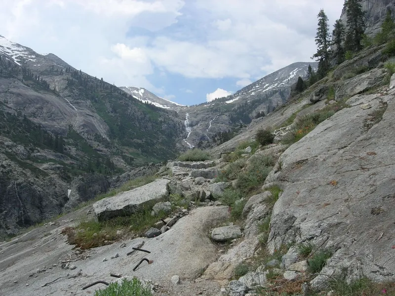
The High Sierra Trail is often described as the "perfect" thru-hike because of its incredible variety and logical progression. Designed and constructed between 1928 and 1932, the trail was specifically engineered to showcase the most dramatic scenery Sequoia National Park has to offer. It does not merely follow the path of least resistance; it is a deliberate piece of landscape architecture that clings to granite cliffs, tunnels through solid rock, and scales massive mountain passes to provide walkers with constant, breathtaking vistas. The journey begins at Crescent Meadow (2,042 m), where the air is thick with the scent of pine and the massive trunks of Sequoia giganteum create a sense of prehistoric scale. As you move eastward, the forest thins, replaced by the dramatic "High Sierra" aesthetic: white granite, sapphire-blue alpine lakes, and jagged skylines.
The physical challenge of the High Sierra Trail is significant. While the trail is well-maintained and engineered for pack animals (meaning gradients are rarely steeper than 10–12%), the sheer volume of climbing and the sustained altitude take a toll. Walkers must cross the Great Western Divide at Kaweah Gap (3,261 m), descend nearly 1,500 metres into the Kern River Canyon, and then climb back out to reach the Whitney Crest. The final push to the summit of Mount Whitney involves a relentless ascent into an environment where oxygen levels are significantly reduced, making every step a conscious effort of will. However, the rewards are unparalleled: the solitude of the Big Arroyo, the therapeutic warmth of the Kern Hot Springs, and the sunrise from the roof of the United States.
Unlike many other trails in the region, the High Sierra Trail offers a sense of profound isolation. Once you cross the Great Western Divide, you are days away from the nearest road. The Kern River Canyon, a massive north-south rift, feels like a world unto itself—a hidden valley of towering ponderosa pines and rushing water. This is a wilderness experience that requires total self-sufficiency, as there are no resupply points or permanent settlements along the route. For those who seek to understand the true scale and majesty of the American West, the High Sierra Trail is an essential pilgrimage.
History and Cultural Context
The High Sierra Trail has a rich history that predates its formal construction. For thousands of years, the Sierra Nevada was home to indigenous peoples, including the Monache (Western Mono) on the western slopes and the Paiute on the eastern side. These groups utilised high mountain passes for trade, exchanging acorns and obsidian across the granite crest. While the modern HST does not follow a single traditional indigenous route, it traverses lands that hold deep spiritual and ancestral significance for these communities.
The modern trail was the brainchild of Stephen Mather, the first director of the National Park Service, and John White, the superintendent of Sequoia National Park. In the 1920s, they envisioned a trail that would allow visitors to cross the entire park from the Giant Forest to Mount Whitney without ever leaving park boundaries. Construction began in 1928, led by skilled trail crews who used dynamite and hand tools to carve the path out of sheer granite walls. One of the most impressive feats of engineering on the trail is the "Hamilton Gorge" section, where the trail is blasted into a vertical cliff face and crosses a dramatic bridge to span a narrow chasm. The trail was completed in 1932, just as the Great Depression was beginning to reshape the American landscape.
The completion of the trail coincided with the growing popularity of the "High Trip" organised by the Sierra Club, which brought hundreds of people into the backcountry to advocate for its protection. Today, the High Sierra Trail stands as a monument to early 20th-century conservation ideals and the belief that wilderness should be accessible to those willing to put in the physical effort to reach it. In 1984, much of the land surrounding the trail was designated as the Sequoia-Kings Canyon Wilderness, ensuring that the pristine character of the landscape would be preserved for future generations.
Want more background? Read extended notes on history and cultural context → Learn more
Seasonal Highlights and Weather Reality
The window for safely walking the High Sierra Trail is relatively narrow due to its high elevation. In a typical year, the trail is buried under several metres of snow from October through June. The "prime" season is generally from mid-July to early September, but this can shift significantly based on the previous winter's snowpack.
Early Season (June to mid-July): During high-snow years, Kaweah Gap and the Whitney Crest may remain impassable without ice axes and crampons well into July. River crossings, particularly in the Big Arroyo and Kern River, can be dangerously high and fast-moving during the peak of the snowmelt. However, this is also when the wildflowers are at their most spectacular and the waterfalls are thundering with power. Mosquitoes are at their peak during this period, often requiring head nets and strong repellent.
Mid-Season (Late July to August): This is the most popular time to hike. The trail is usually clear of snow, river levels have dropped to manageable levels, and the weather is generally stable. However, the Sierra Nevada is famous for its "monsoonal" afternoon thunderstorms. These storms can build rapidly, bringing intense rain, hail, and dangerous lightning. Walkers should aim to be off high passes and exposed ridges by midday to avoid the risk of lightning strikes.
Late Season (September to early October): September offers some of the best walking conditions. The mosquitoes have died off, the thunderstorms are less frequent, and the air is crisp and clear. However, the days are shorter, and night-time temperatures can drop well below freezing. Early autumn snowstorms are a real possibility, and walkers must be prepared for sudden shifts into winter conditions. By mid-October, the high passes are often closed by the first major storms of the season.
Recommended Itinerary
7-Day High Sierra Trail Itinerary
Day 1: Crescent Meadow to Bearpaw Meadow
- Distance: 18.3 km
- Elevation gain: 300 m
- Time: 5–7 hours
- Start at Crescent Meadow trailhead in the Giant Forest
- Walk through ancient Sequoia groves and lush ferns
- Cross Log Meadow and follow the Middle Fork of the Kaweah River
- Steady, gentle climb with views of the Great Western Divide in the distance
- Arrive at Bearpaw Meadow (2,377 m); established wilderness camp with bear boxes and water
- This day serves as an excellent introduction to the trail's gradient and allows for altitude acclimatisation
Day 2: Bearpaw Meadow to Hamilton Lake
- Distance: 6.4 km
- Elevation gain: 450 m
- Time: 3–4 hours
- A shorter day to allow for rest and enjoyment of one of the Sierra's most beautiful lakes
- Cross the dramatic Hamilton Gorge via a steel bridge
- Steep switchbacks lead up to Lower and then Upper Hamilton Lake
- Upper Hamilton Lake (2,510 m) is nestled in a spectacular granite cirque
- Excellent swimming (if you can brave the cold) and photography opportunities
- Campsites are located around the lake with stunning views of Valhalla and Angel Wings
Day 3: Hamilton Lake to Big Arroyo Junction
- Distance: 14.5 km
- Elevation gain: 750 m
- Time: 6–8 hours
- The most dramatic climbing day of the first half
- Ascend the "Hamilton Switchbacks" carved into the cliffside
- Pass the iconic Precipice Lake (3,145 m), made famous by photographer Ansel Adams
- Cross Kaweah Gap (3,261 m), the gateway through the Great Western Divide
- Descend into the vast, glacial basin of the Big Arroyo
- Camp near the historic Big Arroyo Patrol Cabin (2,900 m)
Day 4: Big Arroyo Junction to Kern Hot Springs
- Distance: 21 km
- Elevation loss: 1,100 m
- Time: 7–9 hours
- Cross the Chagoopa Plateau, a high-altitude forested bench
- Long, dusty descent into the Kern River Canyon
- The trail drops steeply via switchbacks to the canyon floor
- Follow the Kern River north to the Kern Hot Springs (2,042 m)
- Soak in the natural hot spring tub next to the rushing river—a highlight of the trip
- Established campsites with bear boxes available
Day 5: Kern Hot Springs to Wallace Creek
- Distance: 22.5 km
- Elevation gain: 950 m
- Time: 8–10 hours
- A long, sustained climb out of the Kern Canyon
- Follow the Kern River through towering pines and granite boulders
- Pass the junction with the John Muir Trail (JMT) and Pacific Crest Trail (PCT)
- Climb steeply up to the Wallace Creek junction (3,170 m)
- Camp near the creek; this is a high-altitude site, so expect cold temperatures
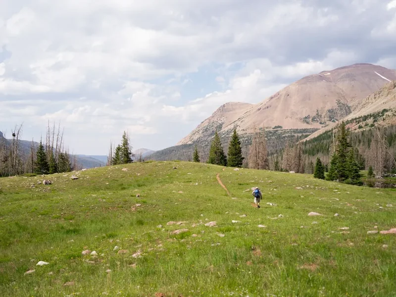
Day 6: Wallace Creek to Guitar Lake
- Distance: 11.5 km
- Elevation gain: 350 m
- Time: 4–5 hours
- A shorter day to prepare for the Whitney summit
- Traverse high alpine meadows with views of the Whitney Crest
- Pass Crabtree Meadow (ranger station and wag bag distribution point)
- Arrive at Guitar Lake (3,500 m), the final staging area for the summit
- No wood fires allowed; very exposed and often windy
- Early night recommended for a pre-dawn summit push
Day 7: Guitar Lake to Whitney Portal via Mount Whitney Summit
- Distance: 21 km
- Elevation: 920 m gain to summit, 1,900 m descent to portal
- Time: 10–14 hours
- Start at 2:00 AM or 3:00 AM to catch sunrise on the summit
- Relentless switchbacks up to Trail Crest (4,168 m)
- Drop packs at the junction and walk the 3 km spur to the summit of Mount Whitney (4,421 m)
- Return to Trail Crest and begin the long, knee-jarring descent of the "99 Switchbacks"
- Pass Trail Camp and Mirror Lake
- Finish at Whitney Portal (2,550 m) for a celebratory burger at the portal store
Important Notes:
- Bear canisters are mandatory for the entire duration of the trip
- Wag bags (human waste disposal bags) are required for the Whitney Zone
- Water can be scarce on the Chagoopa Plateau and the Whitney switchbacks; plan accordingly
- The descent from Trail Crest to Whitney Portal is extremely taxing on the joints
- Shuttle logistics between Crescent Meadow and Whitney Portal are complex and must be organised in advance
Planning and Bookings
Book Your Trip
Everything you need to plan your journey
Accommodation
Find places to stay near Visalia, California
Flights
Search flights to Visalia, California
Essential Preparation
The High Sierra Trail requires meticulous logistical planning, primarily because it is a point-to-point hike with trailheads separated by a five-hour drive. Most walkers choose to leave a vehicle at Whitney Portal (the finish) and use a private shuttle service or a complex series of public buses to reach Crescent Meadow (the start). Alternatively, two groups can start at opposite ends and swap keys in the middle, though this requires perfect coordination. Fitness is paramount; you should be comfortable walking 20 kilometres a day with a 15–20 kg pack at altitudes exceeding 3,000 metres. Acclimatisation is key—spending a night in Visalia or at the Lodgepole Campground before starting can help prevent altitude sickness.
Visalia, California, is the primary gateway city. It offers full services, including gear shops, supermarkets, and hotels. From Visalia, the Sequoia Shuttle provides seasonal transport into the park, though private arrangements are often necessary for the return leg from Lone Pine (the town nearest Whitney Portal) back to the western side of the mountains.
Trail Accommodation
Accommodation on the High Sierra Trail consists almost entirely of wilderness camping. There are no huts in the New Zealand or European sense, with one notable exception. Walkers must be prepared to be fully self-sufficient with their own tent, sleeping bag, and cooking system.
Wilderness Campsites:
- Established sites exist at Bearpaw Meadow, Hamilton Lake, Big Arroyo, Kern Hot Springs, Wallace Creek, and Guitar Lake.
- Most established sites feature communal bear-resistant food lockers (bear boxes), though a portable canister is still legally required.
- Water is generally available from nearby lakes or streams but must be treated.
- Composting toilets are available at Bearpaw Meadow, Crabtree Meadow, and Whitney Portal. Elsewhere, you must bury waste or use wag bags in the Whitney Zone.
Bearpaw High Sierra Camp:
- A seasonal, tent-cabin camp operated by a concessionaire. It provides beds and meals for a high fee.
- Extremely difficult to book; reservations usually happen via a lottery system a year in advance.
- Note: This camp has been closed for several seasons due to maintenance and environmental issues; check current status before planning.
Required Gear
- Bear Canister: An approved hard-sided bear-resistant container is mandatory. Soft bags or "counter-balancing" are not permitted.
- Footwear: Sturdy, well-broken-in hiking boots or trail runners with excellent traction for granite slabs.
- Backpack: 50–70L capacity, fitted correctly to handle the weight of a bear canister and 7 days of food.
- Shelter: A lightweight, 3-season tent capable of withstanding high winds and heavy hail.
- Sleeping System: A sleeping bag rated to at least -5°C. Even in August, alpine temperatures frequently drop below freezing.
- Navigation: Topographic maps (Tom Harrison's HST map is the gold standard) and a GPS/Compass. Do not rely solely on a mobile phone.
- Wag Bags: Specifically required for the Whitney Zone (from Guitar Lake to Whitney Portal). These are often provided at the ranger station but should be carried just in case.
What to Bring
- Food: High-calorie, lightweight meals for 6–8 days. There are no resupply points. Remember that all food, toiletries, and trash must fit inside your bear canister at night.
- Water Treatment: A reliable filter (hollow fibre or ceramic) or chemical treatment (Aquamira/Iodine). Sierra water is generally clear but can carry Giardia.
- Clothing Layers: The "system" approach is essential. Merino base layers, a fleece or "puffy" down jacket for camp, and a high-quality waterproof shell.
- Sun Protection: High-altitude sun is brutal. SPF 50+ sunscreen, polarised sunglasses, and a wide-brimmed hat are non-negotiable.
- First Aid: Focus on blister care (Leukotape/moleskin), electrolyte salts, and Ibuprofen for altitude headaches.
- Stove and Fuel: Lightweight canister stove (Jetboil/PocketRocket). Ensure you have enough fuel for the entire duration, as there is no wood-fire allowed in many high-altitude zones.
Permits
Securing a permit for the High Sierra Trail is a competitive process. Because the trail starts in Sequoia National Park and ends in Inyo National Forest (Mount Whitney), the permit system is managed by Sequoia and Kings Canyon National Parks. You only need one permit for the entire trip, provided your entry point is Crescent Meadow.
The Booking Process:
- Permits are released on Recreation.gov six months in advance on a rolling daily basis. For a mid-August start, you must be online at 7:00 AM PST in mid-February.
- The "Crescent Meadow to Whitney Portal" quota is very small (usually around 20–30 people per day).
- You must specify your entry date, entry trailhead (Crescent Meadow), and your exit trailhead (Whitney Portal).
- A small percentage of permits are held for "walk-up" reservations, which can be claimed at the Lodgepole Visitor Centre starting at 1:00 PM the day before your hike. This is risky for a long thru-hike.
Costs and Regulations:
- Permit fee: Approximately US$15 per permit plus US$5 per person (subject to change).
- You must pick up your physical permit at a ranger station (Lodgepole or Ash Mountain) before starting.
- The permit includes your Mount Whitney summit authorisation; you do not need a separate Whitney lottery permit if you are arriving via the HST.
Other Activities in the Area
The regions surrounding the High Sierra Trail offer world-class attractions for those with extra time:
- General Sherman Tree: Visit the world's largest tree by volume, located just a short drive from the Crescent Meadow trailhead.
- Crystal Cave: Take a guided tour of a spectacular marble cavern in Sequoia National Park (requires separate booking).
- Moro Rock: Climb the 350 steps to the top of this massive granite dome for a panoramic view of the Great Western Divide you are about to cross.
- Alabama Hills: Located near Lone Pine (the finish), these unique rock formations have been the backdrop for hundreds of Hollywood Westerns.
- Manzanar National Historic Site: A sobering and educational visit to the site of a Japanese-American internment camp during WWII, located north of Lone Pine.
- Mount Whitney Fish Hatchery: A beautiful historic building and grounds near Independence, perfect for a relaxing post-hike afternoon.
Safety and Conditions
Altitude Sickness (AMS): This is the primary safety concern on the HST. Much of the trail stays above 3,000 metres, and Mount Whitney reaches 4,421 metres. Symptoms include headache, nausea, and fatigue. The only cure is descent. Walkers should stay hydrated, avoid alcohol, and consider a "climb high, sleep low" strategy where possible. If symptoms progress to confusion or shortness of breath at rest (HAPE/HACE), it is a life-threatening emergency.
Black Bears: Sequoia National Park is home to a large population of American Black Bears. They are highly intelligent and have learned to associate hikers with food. Using a bear canister is not just a rule; it is essential for the bear's survival. A bear that gets human food often becomes aggressive and must be euthanised. Never leave your pack unattended, and keep a clean camp.
Mountain Weather: Afternoon thunderstorms are common. If you see "towering cumulus" clouds (shaped like cauliflower) building by 11:00 AM, expect lightning by 2:00 PM. If caught on a ridge, descend immediately. Avoid standing near lone trees or large bodies of water. Hypothermia can occur even in summer if you get wet and the wind picks up.
River Crossings: In early summer, creeks like Buck Creek or the Big Arroyo can be dangerous. Always unbuckle your waist belt when crossing, wear shoes to protect your feet, and cross at the widest, shallowest point. If in doubt, wait until early morning when the flow is lowest.
Emergency Communication: There is zero mobile phone signal for 95% of the trail. Carrying a satellite messenger (like a Garmin inReach or Zoleo) is highly recommended for summoning help in a medical emergency.
Side Trips and Points of Interest
Precipice Lake: Located just below Kaweah Gap, this lake is famous for its deep teal water and the sheer granite walls that rise directly from its edge. It is often partially frozen well into July. It is widely considered the most beautiful lake in the Sierra and is a mandatory photography stop.
Kern Hot Springs: A natural geothermal spring located on the banks of the Kern River. A small concrete tub has been built to capture the water, which stays at a perfect 38–40°C. It is the ultimate luxury for tired thru-hikers. There is also a "cold plunge" pool in the river for the brave.
Mount Whitney Summit: While technically part of the main route for most HST hikers, the 3 km spur from Trail Crest to the summit is the ultimate "side trip." The summit features a historic stone hut (built in 1909 for Smithsonian researchers) and a register to sign. The views extend across the Owens Valley to the White Mountains in the east and back across the entire Sierra range to the west.
The Chagoopa Plateau: This high-altitude forested bench offers a unique perspective on the Kern River Canyon. It is a place of quiet beauty, with lodgepole pine forests and small meadows that feel untouched by the crowds found elsewhere in the park.
Leave No Trace
The High Sierra is a fragile alpine environment where the growing season is short and the impact of human visitors can last for decades. Adhering to Leave No Trace (LNT) principles is mandatory for all wilderness users.
Key Principles for the HST:
- Dispose of Waste Properly: In the Whitney Zone, you MUST use wag bags to pack out all human waste. In other areas, bury waste in a "cathole" 15–20 cm deep and at least 60 metres from water.
- Respect Water Sources: Never wash dishes or yourself directly in a lake or stream. Carry water 60 metres away and use biodegradable soap sparingly.
- Camp on Durable Surfaces: Use established campsites. Do not expand existing sites or create new ones by clearing vegetation.
- Minimize Campfire Impacts: Fires are prohibited above 3,000 metres and in many other areas due to drought. Use a stove for cooking.
- Leave What You Find: Do not collect rocks, plants, or historical artefacts (like those at the Big Arroyo cabin).
- Keep Wildlife Wild: Never feed marmots, squirrels, or bears. Store all scented items (including toothpaste and lip balm) in your bear canister.