The High Coast Trail (Höga Kustenleden)
The High Coast Trail, or Höga Kustenleden, is a spectacular 128-kilometre hiking route that winds its way through one of Sweden's most geologically unique and visually stunning coastal landscapes. This UNESCO World Heritage site, known for its dramatic cliffs, ancient forests, and archipelago vistas, offers a moderate challenge suitable for most experienced hikers. The trail traverses a region that is still rising from the sea following the last Ice Age, creating a dynamic and ever-changing environment. From the rugged shores of the Baltic Sea to the serene inland forests, the High Coast Trail provides an immersive experience in Sweden's natural beauty and rich cultural heritage.
- Distance: 128.0 km one-way
- Duration: 7–10 days
- Season: May to September
- Difficulty: Moderate
- Highest point: Approximately 200 m (variable due to terrain)
- Accommodation: Huts, cabins, campsites, and hotels along the route
- Closest City: Örnsköldsvik
- Trailhead Access: Örnsköldsvik Airport (OER) is the nearest. Bus 40 from Örnsköldsvik to Hornöberget (start) or taxi. E4 highway access with parking at Hornöberget.
Overview
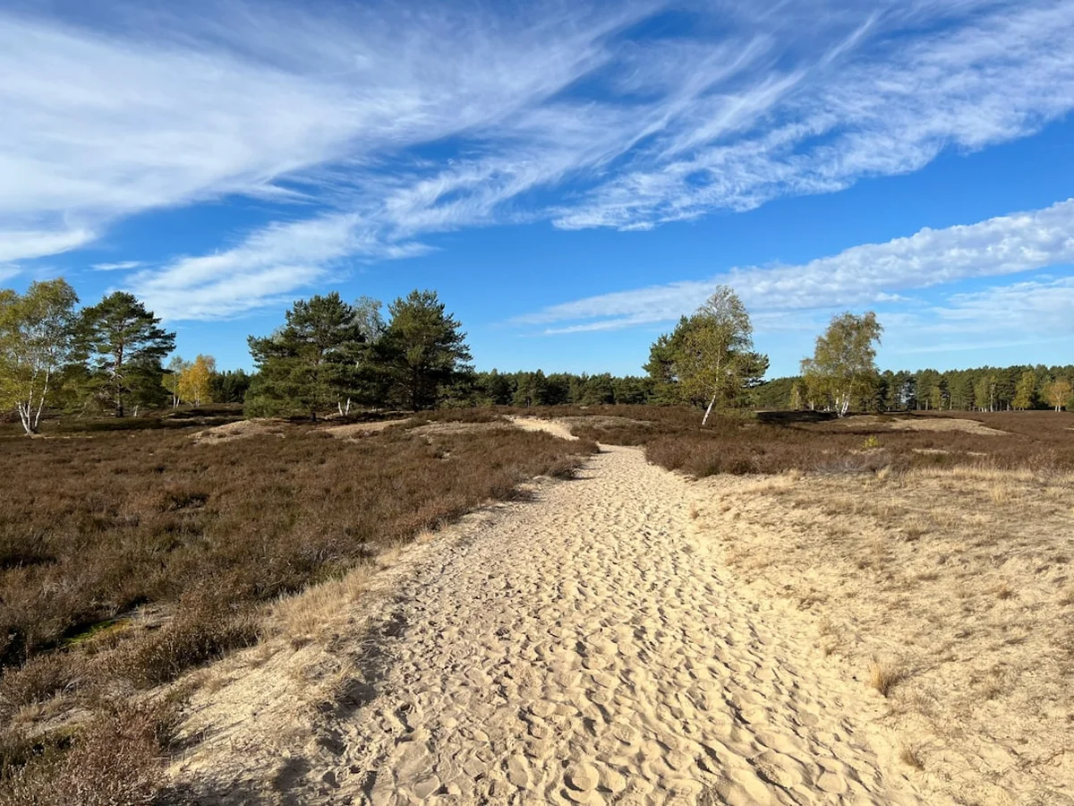
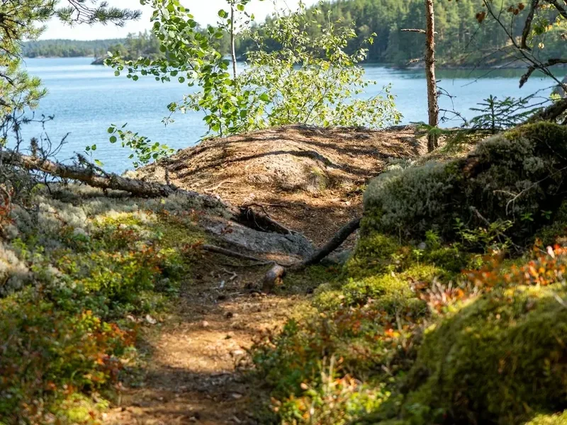
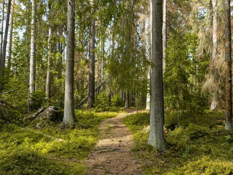
The High Coast Trail is a journey through a landscape shaped by immense geological forces. The land here is still rising at an astonishing rate of 8 mm per year, a phenomenon known as isostatic rebound, which has created dramatic cliffs, deep ravines, and a unique coastal environment. The trail offers a diverse walking experience, from the exposed, windswept shores of the Baltic Sea to the tranquil, ancient forests inland. Hikers will encounter picturesque fishing villages, historic sites, and breathtaking panoramic views that stretch across the archipelago and the Gulf of Bothnia.
The route is well-marked with orange paint strokes on trees and rocks, and signs indicating the trail direction. While the terrain can be rugged in places, with rocky ascents and descents, the overall difficulty is considered moderate. The trail is divided into sections, allowing for flexibility in planning and the possibility of shorter day hikes or multi-day expeditions. The elevation gain is significant but spread out, with no single day presenting an extreme challenge. The highest points are modest, typically around 200 metres above sea level, but the cumulative elevation gain over the entire 128 kilometres is substantial.
The High Coast Trail is more than just a physical challenge; it's an opportunity to connect with nature and history. The region is dotted with remnants of past human activity, from ancient settlements to traditional fishing communities. The trail passes through areas of outstanding natural beauty, including nature reserves and protected landscapes, offering a chance to observe local flora and fauna. The changing seasons bring different colours and moods to the landscape, with spring offering blooming wildflowers, summer providing long, sunny days, and autumn painting the forests in vibrant hues.
History and Cultural Context
The High Coast region has a long and rich history, stretching back thousands of years. Archaeological evidence suggests human settlement in the area since the Stone Age, with findings of ancient burial sites and settlements indicating a continuous human presence. The unique geological phenomenon of land uplift has played a crucial role in shaping the human history of the region. As the land rose from the sea, new areas became available for settlement and agriculture, and the coastline gradually shifted, influencing trade routes and the development of coastal communities.
Historically, the High Coast was an important area for fishing and forestry. Small fishing villages, with their characteristic red wooden houses and drying racks for fish, are still a common sight along the coast. These villages represent a traditional way of life that has been sustained for centuries. The timber industry also played a significant role, with logs floated down rivers to the coast for export. Many of the trails follow old paths used by loggers, fishermen, and farmers.
The designation of the High Coast as a UNESCO World Heritage site in 2000 recognised its outstanding universal value, particularly its unique geological processes and the exceptional coastal landscape that has resulted from land uplift. This recognition has helped to preserve the natural and cultural heritage of the region and promote sustainable tourism. The trail itself often passes through areas that have been protected as nature reserves, safeguarding their ecological integrity and scenic beauty.
Seasonal Highlights and Weather Reality
The High Coast Trail is best experienced from May to September, when the weather is generally most favourable for hiking. Each season offers a distinct experience:
Spring (May to early June): This is a beautiful time to hike as nature awakens. Wildflowers bloom, and the forests begin to turn green. The days are getting longer, and the temperatures are mild, though evenings can still be cool. Snow may linger at higher elevations early in the season, and some sections might still be muddy. Birdlife is abundant as migratory species return.
Summer (mid-June to August): This is the peak hiking season. The days are long, with almost endless daylight in midsummer, allowing for extended hiking hours. Temperatures are typically warm and pleasant, ideal for exploring the coast and forests. However, this is also the time when sandflies can be most prevalent, especially in damp, sheltered areas. The sea can be calm and inviting, and the archipelago is at its most vibrant.
Autumn (September to early October): Autumn offers a spectacular display of colours as the deciduous forests turn shades of red, orange, and yellow. The air is crisp and clear, and the sandfly population usually diminishes. The weather can be more unpredictable, with a higher chance of rain and cooler temperatures, but the fewer crowds and stunning scenery make it a rewarding time to visit. Early snow is possible towards the end of the season.
Weather: The weather on the High Coast can be highly variable, even during the summer months. Coastal areas are exposed to winds from the Baltic Sea, and conditions can change rapidly. Expect sunshine, rain, and wind, sometimes all in the same day. Temperatures can range from 10°C to 25°C in summer. It is essential to be prepared for all types of weather, regardless of the season.
Recommended Itinerary

7-Day High Coast Trail Itinerary (Example)
This itinerary provides a balanced pace, allowing time to enjoy the scenery and explore points of interest. It can be adjusted based on fitness and preferences.
Day 1: Hornöberget to Nordingrå Church (approx. 18 km)
- Start at Hornöberget, a scenic viewpoint with information about the High Coast.
- Hike through varied terrain, including forests and coastal paths.
- Pass by several smaller villages and viewpoints.
- End the day near Nordingrå Church, a historic landmark.
- Accommodation options: Campsite or guesthouse in the Nordingrå area.
Day 2: Nordingrå Church to Ullånger (approx. 20 km)
- Continue through the Nordingrå region, known for its unique geological formations.
- Descend towards the coast and follow sections of the shoreline.
- Pass through charming coastal hamlets.
- Arrive in Ullånger, a larger village with more amenities.
- Accommodation options: Hotel, guesthouse, or campsite in Ullånger.
Day 3: Ullånger to Skuleskogen National Park (approx. 15 km)
- A shorter day, focusing on reaching the renowned Skuleskogen National Park.
- The trail enters the national park, offering dramatic cliff scenery and ancient forests.
- Key features include Slåttdalsskrevan (Slåttdal Ravine), a narrow, impressive gorge.
- Accommodation options: Camping within Skuleskogen National Park (designated areas) or nearby cabins.
Day 4: Exploring Skuleskogen National Park (approx. 10-15 km, flexible)
- Dedicate a full day to exploring the diverse trails within Skuleskogen National Park.
- Hike to viewpoints like Tofvabacken for panoramic views of the archipelago.
- Explore the unique flora and fauna of the park.
- Return to the same accommodation or move to a different point within the park if desired.
Day 5: Skuleskogen National Park to Docksta (approx. 18 km)
- Exit Skuleskogen National Park and continue south.
- The trail may involve some road walking and sections through more open landscapes.
- Pass through smaller communities and enjoy views of the surrounding islands.
- Arrive in Docksta, a village with good amenities.
- Accommodation options: Hotel, guesthouse, or campsite in Docksta.
Day 6: Docksta to Örnsköldsvik (approx. 25 km)
- A longer day, heading towards the main city of Örnsköldsvik.
- The trail may take you through a mix of coastal and inland forest sections.
- Enjoy final views of the High Coast landscape.
- Arrive in Örnsköldsvik, a city with a wide range of accommodation and services.
- Accommodation options: Hotels, hostels, or apartments in Örnsköldsvik.
Day 7: Örnsköldsvik and Departure
- Spend the morning exploring Örnsköldsvik, perhaps visiting the Naturum Höga Kusten (High Coast Nature Centre) or enjoying the city's waterfront.
- Depart from Örnsköldsvik Airport (OER) or continue your journey.
Alternative Itinerary Notes:
- This itinerary can be extended to 10 days for a more relaxed pace or to include more side trips.
- Sections can be hiked as day trips if based in a central location like Ullånger or Docksta.
- Public transport is available along parts of the route, allowing for shorter hikes and flexible end points.
Planning and Bookings
Book Your Trip
Everything you need to plan your journey
Accommodation
Find places to stay near Örnsköldsvik
Flights
Search flights to Örnsköldsvik
Essential Preparation
The High Coast Trail is a well-established route, but preparation is key to a successful and enjoyable hike. Given its moderate difficulty and length, it's suitable for individuals with a reasonable level of fitness and prior hiking experience. The trail is generally well-marked, but carrying a map and compass or GPS device is always recommended, especially for navigating in potentially foggy conditions or exploring side routes.
Fitness: Aim for a good level of cardiovascular fitness. Regular walking, hiking, or running in the weeks leading up to your trip will be beneficial. Practice hiking with a loaded backpack to get accustomed to the weight. The cumulative elevation gain is significant, so building leg strength and endurance is important.
Logistics: The closest major city with an airport is Örnsköldsvik (OER). From Örnsköldsvik, you can take public transport (Bus 40) or a taxi to the trailhead at Hornöberget. If driving, there is parking available at Hornöberget. For multi-day hikes, consider how you will manage your vehicle if you are not doing a loop. Many hikers opt to use public transport to return to their starting point or arrange for a taxi service.
Base Towns: Örnsköldsvik is the largest city and offers the most comprehensive services, including accommodation, restaurants, and outdoor gear shops. Smaller towns like Ullånger, Docksta, and Nordingrå offer more limited but charming options for accommodation and supplies. Planning your resupply points is crucial for longer hikes.
Trail Accommodation
The High Coast Trail offers a variety of accommodation options, catering to different preferences and budgets:
Huts and Cabins: Several designated wilderness huts and cabins are located along the trail, particularly within Skuleskogen National Park and surrounding areas. These often provide basic shelter, sometimes with bunks or sleeping platforms. Booking is usually required, especially during peak season. Facilities are generally basic, with no electricity or running water in many remote huts.
Campsites: Numerous official campsites are available, both within national parks and in smaller villages. These sites typically offer basic amenities such as toilets, and sometimes access to water and cooking facilities. Wild camping is permitted in Sweden under the "Allemansrätten" (Right of Public Access), but it's important to follow guidelines, such as camping away from dwellings and not disturbing the environment. Designated campsites are often preferred for convenience and to minimise impact.
Hotels and Guesthouses: Larger towns like Örnsköldsvik, Ullånger, and Docksta offer hotels, guesthouses, and B&Bs. These provide more comfort and amenities, including private rooms, restaurants, and often Wi-Fi. Booking in advance is highly recommended, especially during the summer months.
Booking Requirements: For official campsites and cabins within national parks, booking is often necessary and can be done online through the Swedish Environmental Protection Agency (Naturvårdsverket) or local tourism websites. Hotels and guesthouses can be booked directly or through standard booking platforms. For wild camping, no booking is required, but adherence to Allemansrätten principles is essential.
Seasonal Availability: Most accommodation options are open from May to September. Some remote huts or campsites might have shorter operating seasons. Hotels and guesthouses in larger towns are generally open year-round.
Costs: Campsite fees typically range from 150-300 SEK per night. Wilderness huts and cabins can cost between 300-800 SEK per night. Hotels and guesthouses vary widely, from 800 SEK upwards.
Required Gear
- Waterproof and windproof jacket and trousers: Essential for unpredictable coastal weather. Look for breathable materials like Gore-Tex.
- Sturdy hiking boots: Waterproof, with good ankle support and a well-worn sole.
- Layered clothing: Merino wool or synthetic base layers, insulating mid-layers (fleece or down), and a warm hat and gloves.
- Backpack: 45-65 litre capacity, with a comfortable hip belt and a rain cover.
- Sleeping bag: Rated for temperatures down to 0-5°C Celsius for comfort, even in summer.
- Sleeping mat: For insulation and comfort, especially if camping or using basic huts.
- Navigation tools: Detailed map of the High Coast Trail, compass, and a GPS device or smartphone with offline maps.
- Head torch: With spare batteries, for early mornings, late evenings, or use in huts/campsites.
- First-aid kit: Including blister treatment, pain relievers, antiseptic wipes, bandages, and any personal medications.
- Sun protection: High SPF sunscreen, sunglasses, and a wide-brimmed hat.
- Insect repellent: Especially for midges and mosquitoes, which can be prevalent in summer.
What to Bring
- Food: Plan your meals for the duration of your hike. Resupply points are available in larger towns, but carrying enough for several days is recommended. Lightweight, high-energy foods are ideal.
- Water bottles or hydration reservoir: Capacity of at least 2-3 litres.
- Water purification method: Filter, purification tablets, or boiling. While many streams are clean, it's always best to treat water.
- Cooking equipment: Lightweight stove, fuel, pot, utensils, mug, and plate/bowl.
- Toiletries: Biodegradable soap, toothbrush, toothpaste, toilet paper, hand sanitiser, and any personal hygiene items.
- Trekking poles: Highly recommended for stability on uneven terrain and to reduce strain on knees.
- Dry bags: To keep essential gear dry inside your backpack.
- Camera: To capture the stunning scenery.
- Book or journal: For downtime in the evenings.
- Cash: For small purchases in villages or for services where card payment might not be accepted.
Permits
Generally, no specific permits are required to hike the High Coast Trail itself. Sweden's "Allemansrätten" (Right of Public Access) grants everyone the freedom to roam the countryside, including hiking on established trails, provided they do so responsibly and with respect for nature and private property.
National Park Regulations: However, within Skuleskogen National Park, there are specific regulations to protect the fragile environment. While hiking is free, camping is restricted to designated areas, and campfires are generally prohibited. Always check the latest regulations for Skuleskogen National Park before your visit. Information is usually available on the Swedish Environmental Protection Agency (Naturvårdsverket) website or at visitor centres.
Accommodation Bookings: If you plan to stay in designated campsites, wilderness huts, or cabins, booking in advance is highly recommended, especially during the peak summer season (June-August). These bookings are typically made through local tourism operators, the park authorities, or specific accommodation providers. Prices vary depending on the type of accommodation.
Fires: Campfires are generally not permitted within Skuleskogen National Park and are often restricted in other sensitive areas. Always check local regulations and use designated fire pits if available and permitted. Be aware of any fire bans that may be in place due to dry conditions.
Respecting Private Property: While Allemansrätten allows access, it's crucial to respect private property. Avoid walking through gardens or cultivated fields, and do not disturb livestock. When wild camping, ensure you are not too close to houses or other dwellings.
Other Activities in the Area
The High Coast region offers a wealth of activities beyond hiking, allowing visitors to fully immerse themselves in the local culture and natural beauty:
- Archipelago Boat Tours: Explore the stunning High Coast archipelago by boat. Various tours depart from towns like Örnsköldsvik and Docksta, offering opportunities to see the islands from a different perspective, visit remote fishing villages, and enjoy the coastal scenery.
- Kayaking and Canoeing: The calm waters of the bays and sheltered parts of the archipelago are ideal for kayaking and canoeing. Rentals are available in several coastal towns, providing an intimate way to experience the coastline.
- Visiting Fishing Villages: Explore charming traditional fishing villages such as Bönhamn, Kärrvik, and Mjällom. These villages offer a glimpse into the region's maritime heritage, with picturesque wooden houses, harbours, and local seafood restaurants.
- Naturum Höga Kusten: Located near the Slåttdal Ravine in Skuleskogen National Park, this nature centre provides excellent information about the geology, flora, fauna, and cultural history of the High Coast. It's a great starting point for understanding the unique environment.
- Climbing and Bouldering: The dramatic cliffs of the High Coast offer opportunities for rock climbing and bouldering for experienced enthusiasts.
- Cycling: Several scenic cycling routes traverse the region, offering a different way to explore the coastal roads and inland landscapes.
- Cultural Heritage Sites: Discover ancient burial grounds, historical churches, and remnants of old settlements that tell the story of human habitation in the region over millennia.
- Local Cuisine: Sample local delicacies, particularly fresh seafood such as herring, salmon, and perch. Many restaurants offer traditional Swedish dishes.
Safety and Conditions
Weather Preparedness: The weather on the High Coast can change rapidly, especially near the coast. Always check the forecast before setting out and be prepared for rain, wind, and cooler temperatures, even in summer. Pack layers of clothing and ensure your waterproofs are in good condition.
Navigation: While the High Coast Trail is generally well-marked with orange paint on trees and rocks, it is essential to carry a map and compass or a GPS device. Fog can descend quickly, reducing visibility significantly. Familiarise yourself with the trail route and landmarks.
Terrain: The trail includes varied terrain, from coastal paths and rocky shores to forest trails and some road sections. Be mindful of slippery surfaces, especially after rain, and uneven ground. Trekking poles can provide extra stability.
Water Sources: Water is generally plentiful from streams and lakes, but it is advisable to treat all water before drinking, especially if you have a sensitive stomach. Filters or purification tablets are recommended. In drier periods, some smaller streams might dry up, so carry sufficient water between reliable sources.
Wildlife: While large predators are rare, you may encounter deer, foxes, and various bird species. Ticks can be present in grassy and wooded areas, especially during warmer months. Take precautions by wearing long trousers tucked into socks and checking yourself for ticks after hiking.
Emergency Contacts: In case of an emergency, the general emergency number in Sweden is 112. Ensure your mobile phone is fully charged and consider carrying a power bank. Inform someone of your hiking plans, including your intended route and expected return time.
Allemansrätten and Respect: Remember that you are hiking in an area where private property rights exist alongside the Right of Public Access. Always be considerate, avoid disturbing wildlife, and leave no trace of your visit.
Side Trips and Points of Interest
Slåttdalsskrevan (Slåttdal Ravine): This is arguably the most iconic natural feature along the High Coast Trail, located within Skuleskogen National Park. It's a dramatic, narrow gorge, approximately 200 metres long, 30 metres high, and only 7 metres wide at its narrowest point. Hiking through this impressive fissure in the rock is a memorable experience, often involving scrambling over large boulders. The sheer scale and the feeling of being enclosed by towering rock walls are awe-inspiring.
Naturum Höga Kusten: Situated near the entrance to Skuleskogen National Park, this visitor centre is an excellent resource for understanding the unique geology and ecology of the High Coast. It offers interactive exhibits, information about the trail, and insights into the land uplift phenomenon. It's a perfect place to start or end your exploration of the park.
Hornöberget Viewpoint: The official starting point of the High Coast Trail, Hornöberget offers spectacular panoramic views over the High Coast Bridge and the surrounding archipelago. It's a great place to get your bearings and appreciate the vastness of the landscape you are about to explore.
Ullånger Archipelago Views: As the trail passes through or near Ullånger, there are numerous opportunities to enjoy views of the intricate archipelago. Small coves, rocky islets, and the shimmering sea create a picturesque coastal panorama.
Traditional Fishing Villages: Detouring slightly from the main trail to visit villages like Bönhamn, Kärrvik, or Mjällom offers a glimpse into the traditional coastal life of the High Coast. These villages often feature charming wooden houses, small harbours, and a peaceful atmosphere. Some may have small cafés or restaurants serving local specialities.
Höga Kusten Bridge: While not directly on the trail for its entire length, the impressive High Coast Bridge is a prominent landmark visible from various points, especially near the start of the trail at Hornöberget. It's a testament to modern engineering in this dramatic landscape.
Leave No Trace
The High Coast Trail traverses a region of exceptional natural beauty and ecological significance, including a UNESCO World Heritage site. Adhering to Leave No Trace principles is paramount to preserving this environment for future generations and ensuring a positive experience for all visitors.
Plan Ahead and Prepare: Research the trail, understand its challenges, and be prepared for varying weather conditions. Pack appropriate gear and sufficient food and water. Familiarise yourself with local regulations, especially concerning camping and fires.
Travel and Camp on Durable Surfaces: Stick to marked trails to avoid damaging vegetation. When camping, use designated campsites or durable surfaces like rock, gravel, or dry grass. Avoid camping in sensitive areas or too close to water sources.
Dispose of Waste Properly: Pack out everything you pack in, including all food scraps, wrappers, and any other litter. Use designated toilets or dig catholes at least 60 metres away from water, trails, and campsites. Pack out used toilet paper.
Leave What You Find: Resist the urge to take souvenirs such as rocks, plants, or historical artefacts. Leave the natural and cultural heritage of the High Coast as you found it.
Minimise Campfire Impacts: Campfires are often prohibited in national parks and sensitive areas. If permitted, use established fire rings and keep fires small. Ensure fires are completely extinguished before leaving.
Respect Wildlife: Observe wildlife from a distance and never feed animals. Feeding wildlife can harm their health, alter their natural behaviours, and expose them to danger.
Be Considerate of Other Visitors: Keep noise levels down, especially in natural quiet areas. Yield to other hikers on narrow trails. Respect the peaceful nature of the wilderness.
Useful Links
- Skuleskogen National Park (Länsstyrelsen Västernorrland)
- High Coast Trail Official Information (Hogakusten.com)
- Allemansrätten - The Right of Public Access (Naturvårdsverket)
- SMHI Weather Forecast (Örnsköldsvik)
- Swedish Transport Administration (for road conditions)
- SJ (Swedish Railways - for train travel)
- Din Buss (for regional bus information)