High Coast Trail (Höga Kustenleden) - A Journey Through the World's Highest Coastline
The High Coast Trail, or Höga Kustenleden, is a spectacular 128.6-kilometre trekking route located in the Västernorrland region of Sweden. This multi-day walk traverses the heart of the High Coast UNESCO World Heritage site, a landscape defined by the most significant post-glacial land uplift ever recorded. Since the retreat of the last ice sheets approximately 10,500 years ago, the land here has risen by an incredible 286 metres, and it continues to rise at a rate of about 8 millimetres per year. This geological phenomenon has created a unique environment where ancient shorelines sit high atop forested mountains, and deep blue fjords cut into rugged granite cliffs. The trail stretches from the impressive High Coast Bridge (Högakustenbron) in the south to the coastal town of Örnsköldsvik in the north, offering hikers a diverse tapestry of primary forests, pebble fields, sandy beaches, and traditional fishing villages.
- Distance: 128.6 km one-way
- Duration: 7–10 days
- Season: May to September (summer months offer the best conditions and longest daylight)
- Accommodation: Wilderness huts, campsites, hostels, and hotels
- Total Elevation Gain: 3,250 m
- Difficulty: Moderate (requires good fitness due to frequent elevation changes)
- Direction: Typically walked south to north (Hornöberget to Örnsköldsvik)
Overview
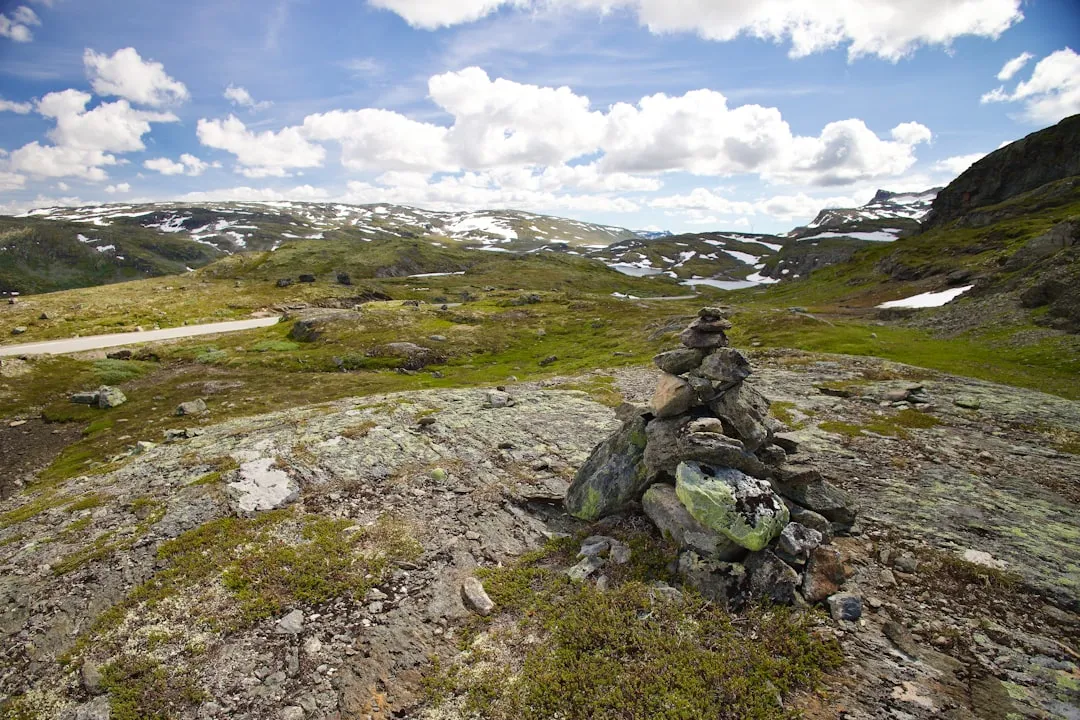
The High Coast Trail is not merely a walk through the woods; it is a journey through a living geological laboratory. The route is divided into 13 distinct stages, each offering a different perspective on the Swedish wilderness. Unlike the flat coastal plains found elsewhere in the Baltic, the High Coast is characterised by its dramatic verticality. Hikers will find themselves climbing steep, forested ridges only to descend into secluded coves where the water is crystal clear and the silence is absolute. The trail is well-marked with orange paint on trees and stones, making navigation straightforward, though the physical demand should not be underestimated. With over 3,000 metres of total ascent, the constant "up and down" nature of the terrain tests the endurance of even experienced trekkers.
One of the most defining features of the trail is the "klapperstensfält" or shingle fields. These are vast expanses of rounded stones, polished by ancient waves, that now sit hundreds of metres above the current sea level. Walking across these fields provides a visceral sense of the earth's movement over millennia. The trail also passes through the Skuleskogen National Park, one of the crown jewels of the Swedish park system. Here, the landscape becomes even more rugged, featuring the famous Slåttdalsskrevan—a massive 200-metre long crevice that bisects a mountain, with vertical walls rising 30 metres on either side.
The experience is deeply rooted in the Swedish concept of "Allemansrätten" or the Right of Public Access. This allows hikers to roam freely, pick berries and mushrooms, and camp almost anywhere, provided they respect the environment and the privacy of local residents. This freedom, combined with the availability of free wilderness huts maintained by the local municipalities, makes the High Coast Trail one of the most accessible yet wild-feeling long-distance paths in Europe. Whether you are seeking the solitude of the deep spruce forests or the charm of a red-painted fishing hut by the sea, the Höga Kustenleden delivers a quintessentially Swedish outdoor experience.
History and Cultural Context
The history of the High Coast is inextricably linked to the ice. During the last Weichselian glaciation, a massive ice sheet several kilometres thick weighed down the Scandinavian landmass. As the ice melted, the pressure was released, and the land began to "rebound" in a process known as isostatic uplift. This process was first scientifically recognised in the 18th century, and the High Coast became the global type-locality for studying this phenomenon. In 2000, UNESCO recognised the area as a World Heritage site, noting that it provides "outstanding opportunities for the understanding of the important processes that formed the glaciated areas of the Earth's surface."
Human history in the region is just as ancient. As the land rose from the sea, prehistoric hunters and gatherers followed the receding shoreline. Throughout the trail, hikers can encounter Bronze Age burial cairns (gravrösen) perched on high ridges that were once coastal viewpoints. These stone mounds serve as silent sentinels, marking the territory of people who lived here thousands of years ago. The cultural landscape is also defined by the "fäbodar" (summer pasture farms) and fishing communities. For centuries, the local population relied on a combination of small-scale farming in the narrow valleys and herring fishing in the Bothnian Sea. The "surströmming" (fermented herring) tradition, famous—or infamous—worldwide, originated in these coastal villages as a way to preserve fish with minimal salt.
The trail itself was inaugurated in the 1980s to promote tourism and allow people to experience the unique geography of the region. It was a collaborative effort between the municipalities of Kramfors and Örnsköldsvik. Today, the trail is a source of immense local pride, maintained by dedicated teams who ensure the paths are clear and the wilderness huts are stocked with firewood. Walking the trail is as much a cultural immersion into the Swedish "friluftsliv" (open-air life) philosophy as it is a physical challenge.
Want more background? Read extended notes on history and cultural context → Learn more
Seasonal Highlights and Weather Reality
The High Coast Trail is primarily a summer destination, with the main hiking season running from late May to late September. During this window, the weather is generally mild, and the days are incredibly long, providing ample time to complete stages without the pressure of fading light.
Spring (May to June): This is a time of awakening. The forests are vibrant with new growth, and wildflowers like the Calypso orchid begin to bloom. However, some sections of the trail can be very boggy as the last of the snow melts, and the water in the lakes is still too cold for swimming. The "Midnight Sun" effect is strongest in late June, where the sky never truly gets dark, creating a surreal and beautiful atmosphere for evening hiking.
Summer (July to August): This is the peak season. Temperatures typically range from 15°C to 25°C, making for comfortable walking conditions. The sea becomes warm enough for a quick dip in the sheltered coves. This is also the best time for foraging; wild blueberries and raspberries line the trail in abundance. The downside is that this is also the season for mosquitoes and horseflies, particularly in the denser forest sections, so repellent is essential.
Autumn (September): Many locals consider this the best time to hike. The air is crisp and clear, the insects have disappeared, and the "höstfärger" (autumn colours) transform the birch and aspen trees into a sea of gold and orange. Night temperatures can drop toward freezing, and the days shorten significantly, but the lack of crowds and the stunning scenery make it highly rewarding.
Winter (October to April): The trail is not maintained for hiking during winter. Heavy snow covers the markings, and many sections become impassable without snowshoes or skis. The wilderness huts remain open, but reaching them requires advanced winter navigation skills and specialised equipment. Daylight is very limited, with the sun setting as early as 2:30 PM in December.
Recommended Itinerary
7-Day High Coast Trail Itinerary
Day 1: Hornöberget to Lövvik
- Distance: 19.3 km
- Elevation gain: 450 m
- Key Waypoints: High Coast Bridge, Hornöberget viewpoint, Lövvik village
- Start at the southern trailhead near the High Coast Bridge, an architectural marvel spanning the Ångermanälven river
- The trail begins with a steady climb offering immediate views of the fjord
- Pass through varied forest and over rocky outcrops
- Arrive in Lövvik, a charming coastal village with a small harbour
- Accommodation: Lövvik hostel or camping near the shore
Day 2: Lövvik to Fjärdbotten
- Distance: 17.5 km
- Elevation gain: 520 m
- Key Waypoints: Valkallen mountain, Fjärdbotten fäbodar
- Includes a steep optional climb up Valkallen (240 m) for one of the best 360-degree views on the trail
- The route moves inland through dense spruce forests and past quiet lakes
- Descent into Fjärdbotten, a historic summer pasture site by the sea
- Accommodation: Wilderness huts at Fjärdbotten (free) or camping in the meadow
Day 3: Fjärdbotten to Gavik
- Distance: 12.8 km
- Elevation gain: 380 m
- Key Waypoints: Grönsvik, Gaviksfjärden
- A shorter day allowing for a more relaxed pace through coastal landscapes
- The trail follows the shoreline of Gaviksfjärden, offering many spots for swimming
- Pass through small hamlets and agricultural land
- Accommodation: Camping near Gavik or local B&B options
Day 4: Gavik to Lappudden
- Distance: 24.5 km
- Elevation gain: 610 m
- Key Waypoints: Nordingrå church town, Ringkallen mountain, Lappudden
- A long and demanding day through the heart of the Nordingrå peninsula
- The terrain is rugged with frequent elevation changes
- Pass through the "World Heritage Village" of Nordingrå with its historic church stables
- Finish at Lappudden, an ancient Sami site located on a beautiful peninsula in Lake Vågsfjärden
- Accommodation: Lappudden Friluftscenter (cabins and camping)
Day 5: Lappudden to Skuleskogen National Park (South Entrance)
- Distance: 18.2 km
- Elevation gain: 490 m
- Key Waypoints: Ullånger, Skuleberget (side trip), Skuleskogen boundary
- The trail passes through the town of Ullånger, a good spot for restocking supplies
- Optional detour to Skuleberget, the highest point of the ancient coastline
- Enter the southern gates of Skuleskogen National Park, a wilderness of old-growth forest and granite plateaus
- Accommodation: Wilderness huts within the park (e.g., Kälaviken or Tärnättholmarna)
Day 6: Skuleskogen National Park to Köpmanholmen
- Distance: 16.4 km
- Elevation gain: 450 m
- Key Waypoints: Slåttdalsskrevan, Slåttdalsberget, Näske village
- The highlight of the trip: traversing the Slåttdalsskrevan crevice
- Climb Slåttdalsberget for views over the archipelago and the red granite cliffs
- Exit the park at the North Entrance and walk toward the village of Köpmanholmen
- Accommodation: Köpmanholmen hostel or local camping
Day 7: Köpmanholmen to Örnsköldsvik
- Distance: 19.9 km
- Elevation gain: 350 m
- Key Waypoints: Balesudden Nature Reserve, Svedjeholmen, Örnsköldsvik centre
- The final stretch passes through the beautiful Balesudden reserve with its clear forest tarns
- The trail becomes more urban as it approaches the city
- Finish at the town square in Örnsköldsvik, marked by a final trail sign
- Celebratory meal in town before departing via train or bus
Important Notes:
- The trail can be extended to 10 days by breaking the longer stages (Day 4 and Day 7) into smaller sections
- Water is generally available from lakes and streams but should be treated
- The orange markings are very frequent, but a map is still essential for planning
- Public transport (Bus 40) connects the start and end points via the E4 highway
Planning and Bookings
Book Your Trip
Everything you need to plan your journey
Accommodation
Find places to stay near Örnsköldsvik
Flights
Search flights to Örnsköldsvik
Essential Preparation
The High Coast Trail requires a moderate to high level of fitness. While the maximum elevation is only around 300 metres, the cumulative gain over the 128 kilometres is significant. Hikers should be comfortable carrying a full pack (12–15 kg) for 6–8 hours a day over uneven terrain. Preparation should include several day hikes with a weighted pack to condition the legs and back.
Logistically, the trail is well-supported. The closest major city is Örnsköldsvik, which has a regional airport and excellent train connections to Stockholm (approx. 5–6 hours). The southern trailhead at Hornöberget is easily reached by bus from either Örnsköldsvik or Kramfors. It is highly recommended to base yourself in Örnsköldsvik for a night before or after the hike to organise gear and enjoy the local amenities. There are several outdoor retailers in the city centre where you can purchase fuel canisters (gas) and last-minute supplies.
Trail Accommodation
Accommodation on the High Coast Trail is a mix of free wilderness huts, paid hostels, and wild camping. This variety allows for different budget levels and comfort preferences.
Wilderness Huts (Stugor): There are approximately 20 small huts along the route. These are basic wooden structures provided by the municipalities. They typically contain wooden bunks (no mattresses), a wood-burning stove for heat, and a table. They are free to use on a first-come, first-served basis. You cannot book these, and you are expected to share the space with other hikers. You must bring your own sleeping mat and sleeping bag.
Hostels and B&Bs: In villages like Lövvik, Lappudden, and Köpmanholmen, there are private hostels and B&Bs. These offer beds with mattresses, showers, and kitchen facilities. These should be booked in advance, especially during the peak months of July and August. Prices range from 300 SEK to 800 SEK per night.
Camping: Under the Right of Public Access, you can camp almost anywhere along the trail for one night. However, within Skuleskogen National Park, camping is strictly limited to designated sites near the wilderness huts to protect the fragile ecosystem. These sites often have prepared fire pits and composting toilets.
Required Gear
- Hiking Boots: Sturdy, waterproof boots with good ankle support are essential. The trail involves many rocky sections and slippery roots.
- Rain Gear: A high-quality waterproof jacket and trousers (Gore-Tex or similar). The High Coast can experience sudden, heavy rain showers.
- Backpack: A 50–65 litre pack with a proper suspension system and rain cover.
- Sleeping System: A 3-season sleeping bag (comfort rating 0°C to 5°C) and a lightweight inflatable or foam sleeping mat.
- Navigation: A physical map of the High Coast Trail (available at local tourist offices) and a compass or GPS device.
- First Aid Kit: Including blister plasters (Compeed), antiseptic wipes, painkillers, and any personal medications.
- Multi-tool or Knife: For gear repairs and food preparation.
- Head Torch: Essential for use inside the wilderness huts, even during the long days of summer.
What to Bring
- Food: Enough supplies for at least 3–4 days. While you pass through villages like Ullånger, shops are infrequent. Focus on lightweight, high-calorie dehydrated meals, nuts, and dried fruit.
- Water Treatment: A lightweight filter (e.g., Sawyer Squeeze) or purification tablets. While Swedish water is generally clean, the trail passes through agricultural areas where runoff can occur.
- Cooking Equipment: A lightweight camping stove (Jetboil or Trangia), fuel, a pot, and a spork.
- Toiletries: Biodegradable soap, toothbrush, toothpaste, and a small trowel for waste (if not near a composting toilet).
- Sun Protection: SPF 30+ sunscreen, sunglasses, and a wide-brimmed hat. The sun can be surprisingly intense on the exposed granite ridges.
- Insect Repellent: A strong repellent containing DEET or Picaridin to ward off mosquitoes and ticks.
- Power Bank: To keep your phone and camera charged, as there is no electricity in the wilderness huts.
Permits
One of the greatest advantages of hiking in Sweden is that no permits are required to walk the High Coast Trail. There are no entry fees for the Skuleskogen National Park, and the use of the wilderness huts is free of charge. This is all made possible by the Swedish "Allemansrätten" (Right of Public Access).
Key Regulations to Observe:
- While no permit is needed, you must follow the specific rules of Skuleskogen National Park. This includes only camping in designated areas and only starting fires in provided fire pits using the wood supplied by the park rangers.
- Groups larger than 10 people may need to contact the County Administrative Board (Länsstyrelsen) if they plan to stay in the national park, as large groups can put undue stress on the facilities.
- Fishing in the sea is free, but if you wish to fish in the inland lakes and streams along the trail, you must purchase a local fishing permit (fiskekort), which can often be bought online or at local petrol stations.
Logistical Costs: While the trail itself is free, you should budget for transport. A bus ticket from Örnsköldsvik to the southern trailhead costs approximately 100–150 SEK. If you choose to stay in hostels or B&Bs, expect to pay between 350 and 700 SEK per night. Food costs in Sweden are relatively high, so many hikers choose to bring their own dehydrated meals from home.
Other Activities in the Area
The High Coast region offers a wealth of experiences beyond the main trail. If you have extra time, consider these additions:
- Via Ferrata at Skuleberget: For those seeking an adrenaline rush, Skuleberget mountain features four different Via Ferrata routes of varying difficulty. It is the largest facility of its kind in Scandinavia, allowing you to climb the sheer eastern face of the mountain safely.
- Ulvön Island: Take a ferry from Köpmanholmen to Ulvön, the "Gem of the Bothnian Sea." This historic fishing village is the home of surströmming and offers beautiful wooden architecture, small shops, and excellent seafood restaurants.
- Kayaking the Archipelago: Rent a sea kayak in Grundsunda or Köpmanholmen to explore the islands from the water. The sheltered bays and clear water make it a world-class paddling destination.
- Mannaminne: Located in Nordingrå, this is a unique "open-air museum" and art installation created by artist Anders Åberg. It features buildings, vehicles, and art from all over the world, including a Hungarian tavern and a Norwegian stave church.
- Slåttdalsskrevan Exploration: Even if you aren't hiking the full trail, a day trip into Skuleskogen to see the crevice is a must. The geological scale of the vertical granite walls is truly humbling.
Safety and Conditions
Terrain Hazards: The High Coast Trail is notoriously "rooty" and "rocky." In wet weather, the granite slabs and exposed tree roots become extremely slippery. Ankle injuries are the most common medical issue on the trail. Take your time on descents and use trekking poles for added stability. The shingle fields (klapperstensfält) can also be unstable; ensure each step is secure before committing your weight.
Weather Awareness: While summer weather is generally stable, the High Coast is prone to rapid changes. Sea fogs can roll in quickly, reducing visibility to a few metres, especially on the higher plateaus like Slåttdalsberget. Always carry a waterproof layer and a warm fleece, even if the day starts sunny. Check the Swedish Meteorological and Hydrological Institute (SMHI) forecast regularly.
Ticks and Lyme Disease: Ticks are prevalent in the tall grass and forested sections of the trail from May to September. Some ticks in Sweden carry Lyme disease or TBE (Tick-borne encephalitis). Wear long trousers tucked into socks when walking through dense vegetation, use repellent, and perform a thorough "tick check" on your body every evening. If you find a tick, remove it immediately with tweezers.
Water Safety: Do not drink water from stagnant ponds or slow-moving streams near agricultural land. While the water in the national park is generally excellent, it is always safer to use a filter or purification tablets to avoid giardia or other water-borne pathogens.
Emergency Contacts: The universal emergency number in Sweden is 112. Mobile phone coverage is generally good along the coast and on higher ground, but it can be spotty in the deep valleys and within the densest parts of Skuleskogen National Park. It is wise to inform someone of your planned itinerary and expected finish date.
Side Trips and Points of Interest
Slåttdalsskrevan: This is the most iconic landmark on the trail. Located in Skuleskogen National Park, it is a 200-metre long, 30-metre deep, and 7-metre wide crevice that was formed when a softer diabase vein eroded away from the surrounding hard granite. Walking through the bottom of the crevice, with the towering walls on either side, is a highlight of the entire journey. Note that the trail through the crevice can be closed occasionally due to the risk of falling rocks; always check the park noticeboards.
Mount Skuleberget: Rising 295 metres above the sea, this mountain is the highest point of the ancient coastline. A side trip to the summit (either via the trail or the cable car) provides a panoramic view of the entire High Coast archipelago. The summit cabin serves "våfflor" (Swedish waffles) during the summer months, providing a perfect reward for the climb.
Balesudden Nature Reserve: Located just south of Örnsköldsvik, this reserve features dramatic coastal cliffs and the beautiful Balestjärnen—a small forest lake known for its incredible clarity and turquoise hue. The water is so clear that you can see sunken trees on the lake bed many metres below the surface. It is a perfect spot for a final wilderness camp before reaching the city.
The Bronze Age Cairns: Keep an eye out for large mounds of stones on the high ridges, particularly near Lövvik and Gavik. These are burial sites from the Bronze Age. Because of the land uplift, these cairns, which were originally built at the water's edge, are now located high above the sea, providing a silent timeline of the region's geological and human history.
Leave No Trace
The High Coast Trail passes through sensitive ecosystems, including ancient forests and rare coastal heathlands. Preserving this environment is the responsibility of every hiker. The Swedish concept of "Allemansrätten" comes with the heavy responsibility of "Don't disturb, don't destroy."
Core Principles for the High Coast:
- Pack it in, pack it out: There are no rubbish bins along the trail or at the wilderness huts. You must carry all your trash, including food scraps and hygiene products, back to the towns for proper disposal.
- Respect the Huts: If you use a wilderness hut, leave it cleaner than you found it. Sweep the floor, restock the firewood you used, and ensure the door is securely latched. Never leave food behind in the huts, as it attracts rodents.
- Fire Safety: Only light fires in designated fire pits. During dry spells, a total fire ban (eldningsförbud) may be in place. Always check the local municipality website for fire warnings. If you do light a fire, ensure it is completely extinguished with water before you leave.
- Protect the Water: Wash yourself and your dishes at least 30 metres away from lakes and streams. Use only biodegradable soap, and even then, use it sparingly.
- Stay on the Path: In Skuleskogen National Park and other nature reserves, stay on the marked orange trail to prevent soil erosion and the destruction of rare mosses and lichens.
- Wildlife: Observe animals from a distance. The High Coast is home to moose (elk), roe deer, and various bird species. Never feed the wildlife, as it disrupts their natural foraging habits.