High Atlas Traverse - The Roof of North Africa
The High Atlas Traverse is Morocco’s most iconic mountain journey—a 60.0 km expedition through the rugged heart of the Toubkal National Park. This challenging route is far more than a simple ascent of North Africa’s highest peak; it is a profound immersion into the ancient landscapes and resilient cultures of the Amazigh (Berber) people. Starting from the bustling mountain trailhead of Imlil, the traverse winds through high-altitude passes, deep limestone gorges, and remote alpine valleys where traditional stone villages cling precariously to the hillsides. The journey culminates in the shadow of Jebel Toubkal (4,167 m), offering trekkers a perspective of the Maghreb that few ever witness. This is a landscape of stark contrasts, where sun-scorched rock faces meet permanent snowfields, and where the legendary hospitality of the mountain people provides a warm counterpoint to the demanding physical environment.
- Distance: 60.0 km (approximate depending on side trips)
- Duration: 5–7 days
- Season: May–June and September–October (optimal windows)
- Accommodation: Mountain refuges, village gîtes, and high-altitude campsites
- Highest point: Tizi n'Aguelzim (3,560 m) or Jebel Toubkal summit (4,167 m)
- Difficulty: Challenging (requires high fitness and acclimatisation)
- Direction: Typically a circuit or point-to-point starting from Imlil
Overview
The High Atlas Traverse is a masterclass in high-altitude trekking, offering a scale and drama that often surprises those who associate Africa solely with savannahs or deserts. The High Atlas range, or the 'Idraren Draren' (Mountains of Mountains) as the locals call it, forms a formidable barrier between the mild Mediterranean climate of the north and the encroaching sands of the Sahara to the south. This traverse takes you through the most dramatic section of the range, where the geology shifts from red sandstone and green marls to the dark, jagged basalt of the highest massifs.
The experience is defined by the rhythm of the "Tizi"—the high mountain passes. Each day involves ascending a significant pass, often exceeding 3,000 metres, only to descend into a completely different valley system. One moment you are walking through lush, terraced walnut groves and apple orchards irrigated by ancient "seguias" (water channels); the next, you are traversing a lunar landscape of scree and boulders where only the hardiest alpine plants survive. The physical challenge is significant, with a total elevation gain of approximately 4,000 metres over the course of the trek. The air is thin, the sun is intense, and the terrain is relentlessly rocky, demanding sturdy footwear and a steady pace.
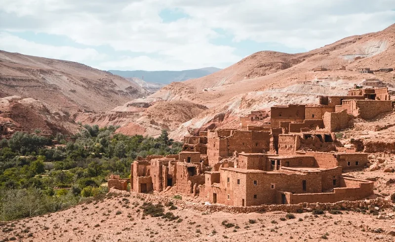
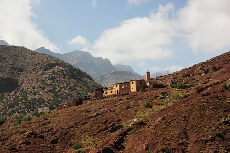
What sets the High Atlas Traverse apart from other great mountain walks is the living cultural landscape. Unlike the wilderness areas of North America or New Zealand, the Atlas is a working landscape. You will share the trails with mule trains transporting supplies to remote outposts, encounter shepherds tending flocks of goats on impossible slopes, and pass through villages that have remained largely unchanged for centuries. The architecture—flat-roofed houses built from local stone and earth—blends so perfectly with the mountainside that villages are often invisible from a distance until you are right upon them. This synergy between man and mountain adds a layer of depth to the trek that elevates it from a mere physical feat to a cultural odyssey.
While the ascent of Jebel Toubkal is the primary draw for many, the traverse itself provides the necessary acclimatisation and a much broader understanding of the region. By the time you reach the base of the highest peaks, you have earned your place in the thin air, having crossed the Tizi n'Tacheddirt and the Tizi n'Aguelzim. The reward is a 360-degree panorama that, on a clear day, stretches from the shimmering heat haze of the Marrakech plains to the distant, golden fringes of the Sahara Desert.
History and Cultural Context
The High Atlas has been the ancestral home of the Amazigh (Berber) people for millennia. Long before the arrival of Arab dynasties or European explorers, the Amazigh developed a sophisticated mountain culture based on transhumance and terrace farming. Their history is one of fierce independence; the mountains served as a natural fortress, allowing them to preserve their language (Tamazight), their unique social structures, and their architectural traditions against successive waves of outside influence. Even today, the village "Djemaa" (council of elders) remains a vital part of local governance in the more remote valleys of the traverse.
European interest in the High Atlas began in earnest during the late 19th and early 20th centuries. The first recorded ascent of Jebel Toubkal by Europeans was in 1923 by the Marquis de Segonzac, Vincent Berger, and Hubert Dolbeau. However, it is widely acknowledged that local hunters and shepherds had likely reached the summit long before. The establishment of the Toubkal National Park in 1942, during the French Protectorate era, marked the beginning of the region's development as a premier trekking destination. The French Alpine Club (CAF) played a crucial role in this era, constructing the first mountain refuges that still serve as vital hubs for trekkers today.
The cultural context of the trail is also shaped by the "Marabout" tradition—the veneration of local saints. Along the traverse, you may encounter small, white-domed shrines known as "koubbas." These are places of pilgrimage and spiritual significance, often located near water sources or prominent mountain features. Respecting these sites and the local customs surrounding them is an essential part of the trekking experience. The 2018 safety regulations, which introduced mandatory local guides for certain sections of the park, have further integrated the local community into the trekking economy, ensuring that the benefits of tourism are shared by the mountain villages you pass through.
Want more background? Read extended notes on history and cultural context → Learn more
Seasonal Highlights and Weather Reality
The High Atlas is a land of climatic extremes, and timing your traverse is critical for both safety and enjoyment. Unlike the European Alps, the trekking season here is split by the intense heat of mid-summer and the heavy snows of winter.
Spring (May to June): This is arguably the finest time for the traverse. The high passes are usually clear of snow, but the peaks remain capped in white, providing stunning photographic contrasts. The valleys are at their most vibrant, with wildflowers in bloom and the terraced fields a brilliant emerald green. Temperatures are pleasant for walking, though it can still be chilly at night above 3,000 metres.
Autumn (September to October): The second "sweet spot" for trekkers. The summer heat has dissipated, and the air is often exceptionally clear, offering the best long-distance views. This is the harvest season in the valleys; you will see villagers gathering walnuts and apples, and the scent of woodsmoke hangs in the evening air. The first dustings of winter snow may appear on the highest summits toward the end of October.
Summer (July to August): While trekking is possible, the heat in the lower valleys (below 2,000 metres) can be punishing, with temperatures often exceeding 35°C. High-altitude sections remain cooler, but the risk of violent afternoon thunderstorms increases. If trekking in summer, early starts are mandatory to avoid the midday sun.
Winter (November to April): During these months, the High Atlas Traverse becomes a serious winter mountaineering undertaking. The trails are buried under snow, and the high passes require ice axes, crampons, and winter navigation skills. Temperatures can drop to -15°C or lower at night. This season is only recommended for experienced alpine climbers or those on guided winter expeditions.
Recommended Itinerary
6-Day High Atlas Traverse Itinerary
Day 1: Imlil to Tacheddirt
- Distance: 12 km
- Elevation gain: 800 m
- Time: 5–6 hours
- Start in Imlil (1,740 m), the trekking hub of the Atlas
- Ascend through walnut groves to the Tizi n'Tamatert pass (2,279 m)
- Enjoy views of the Imlane and Imnane Valleys
- Descend slightly before a final climb to Tacheddirt (2,314 m), the highest village in the region
- Stay in a local village gîte and experience traditional Amazigh hospitality
Day 2: Tacheddirt to Azib n'Tansoult
- Distance: 14 km
- Elevation gain: 1,100 m
- Time: 7–8 hours
- A demanding day crossing the Tizi n'Likemt (3,555 m)
- Steep zigzag ascent on rocky terrain
- Spectacular views of the surrounding 4,000-metre peaks
- Long descent into the Azaden Valley
- Arrive at the summer pastures of Azib n'Tansoult (2,250 m)
- Stay in a mountain refuge or camp near the Ighouliden Waterfalls
Day 3: Azib n'Tansoult to Toubkal Refuge
- Distance: 10 km
- Elevation gain: 1,300 m
- Time: 6–7 hours
- Ascend the "Aguelzim Switchbacks"—a series of 90+ turns
- Cross the Tizi n'Aguelzim (3,560 m) for incredible views of the Toubkal Massif
- High-altitude traverse across rocky plateaus
- Descend to the Neltner/Toubkal Refuges (3,207 m)
- This is the primary base camp for the summit attempt
Day 4: Summit Jebel Toubkal and descend to Lac d'Ifni
- Distance: 12 km
- Elevation gain: 960 m to summit, 1,800 m descent
- Time: 8–10 hours
- Pre-dawn start for the summit of Jebel Toubkal (4,167 m)
- Steep climb through the South Cirque (scree and boulders)
- Reach the summit for sunrise over the Atlas and Sahara
- Descend back to the refuge for a quick break
- Continue the descent over the Tizi n'Ouannoums (3,664 m)
- Arrive at the stunning Lac d'Ifni (2,295 m), the only natural lake in the massif
Day 5: Lac d'Ifni to Amsouzert
- Distance: 8 km
- Elevation loss: 550 m
- Time: 3–4 hours
- A shorter, recovery-focused day
- Follow the river valley down from the lake
- Pass through remote hamlets and terraced fields
- Arrive in the beautiful village of Amsouzert (1,740 m)
- Explore the village and enjoy a traditional tagine in a local home
Day 6: Amsouzert to Imlil (via Tizi n'Ourai)
- Distance: 15 km
- Elevation gain: 1,200 m
- Time: 7–8 hours
- Final big climb to the Tizi n'Ourai (3,109 m)
- Last views of the southern face of Toubkal
- Long descent through the villages of the Mizane Valley
- Return to Imlil to complete the traverse
- Transfer back to Marrakech for a well-earned hammam
Important Notes:
- Itinerary can be adjusted based on fitness and weather conditions
- Mule support is highly recommended for carrying heavy gear
- Acclimatisation is key; do not rush the first two days
- Water sources are available but must be treated
- Local guides are mandatory for the Toubkal section of the park
Planning and Bookings
Book Your Trip
Everything you need to plan your journey
Accommodation
Find places to stay near Marrakech
Flights
Search flights to Marrakech
Essential Preparation
The High Atlas Traverse requires careful logistical planning, primarily centred around Marrakech, which serves as the gateway to the mountains. Most trekkers spend 1–2 nights in Marrakech before and after the trek to organise supplies and transport. From Marrakech, you must arrange a "grand taxi" or a private transfer to Imlil. This takes approximately 90 minutes. It is highly recommended to book your mountain guide in advance, as they will coordinate the hiring of mules and "muleteers" (cooks/handlers), which are essential for a multi-day traverse.
Physical preparation is vital. You will be walking for 6–8 hours a day on very rocky, uneven terrain at altitudes where oxygen is significantly reduced. Cardiovascular training and hiking with a weighted pack in the months leading up to the trip are strongly advised. Additionally, ensure you have a basic understanding of French or a few words of Arabic/Tamazight, as this goes a long way in the mountain villages.
Trail Accommodation
Accommodation on the High Atlas Traverse is a mix of mountain refuges and village gîtes. These provide a unique insight into local life but are generally basic.
Refuges (e.g., Neltner/Toubkal Refuge):
- Dormitory-style bunk beds with thin mattresses
- Shared cold-water bathrooms (some have hot showers for a small fee)
- Common dining areas where meals are served
- No heating (can be very cold at night)
- Solar power for limited lighting; charging facilities are rare and often unreliable
- Cost: Approximately 150–250 MAD per night
Village Gîtes (Gîtes d'étape):
- Traditional Berber homes modified for guests
- Sleeping on floor mats in communal rooms or simple bunk beds
- Excellent home-cooked meals (tagines, couscous, harira soup)
- Basic squat toilets and occasionally a "hammam" style shower
- A very authentic cultural experience
- Cost: Approximately 200–300 MAD including dinner and breakfast
Camping: Wild camping is permitted in many areas, but it is best to camp near refuges or "azibs" (summer pastures) where water is available. You must be self-sufficient with a high-quality 4-season tent and warm sleeping bag.
Required Gear
- Trekking boots: High-cut with stiff soles for rocky terrain and scree slopes
- Walking poles: Essential for saving knees on the long, steep descents
- Layered clothing: Moisture-wicking base layers, fleece mid-layer, and a down jacket for evenings
- Hard-shell jacket: Fully waterproof and windproof for high passes
- Sun protection: Category 4 sunglasses, wide-brimmed hat, and high-SPF sunscreen
- Sleeping bag: 4-season rated (comfort level -5°C to -10°C) even in summer
- Head torch: With spare batteries for pre-dawn summit starts
- Personal first aid kit: Including blister pads, rehydration salts, and altitude medication (consult a doctor)
What to Bring
- Water purification: Chlorine tablets or a high-quality filter (e.g., Sawyer Squeeze)
- High-energy snacks: Nuts, dried fruit, energy bars, and chocolate (limited availability on trail)
- Electrolyte powder: To combat dehydration in the dry mountain air
- Cash (Moroccan Dirhams): Essential for tips, showers, and small purchases in villages (no ATMs on trail)
- Biodegradable toiletries: Including wet wipes and hand sanitiser
- Power bank: To keep phones and cameras charged
- Lightweight towel: Quick-dry microfibre
- Small gifts: Such as pens or postcards for village children (avoid giving sweets)
Permits
Currently, there is no formal "permit" system in the sense of a paper document that must be applied for months in advance. However, since late 2018, strict security regulations have been implemented within the Toubkal National Park. These regulations are strictly enforced at checkpoints along the Mizane Valley and the approach to Jebel Toubkal.
Mandatory Guide Requirement: It is now mandatory for all trekkers to be accompanied by a certified local mountain guide to access the Toubkal massif. You will be required to show your passport at several police checkpoints (Imlil, Aroumd, and the refuge). Your guide will handle the registration process at these points. Attempting to trek without a guide in these restricted areas will result in being turned back by the Royal Moroccan Gendarmerie.
National Park Fees: While there is no entry fee for the park itself, the costs of the mandatory guide and the refuge stays act as the primary financial requirements. Guide rates are regulated by the Bureau des Guides in Imlil and typically range from 400 to 600 MAD per day, depending on the group size and itinerary complexity.
Passport: You must carry your original passport with you at all times during the trek. Photocopies are often not accepted at the high-altitude checkpoints.
Other Activities in the Area
The High Atlas and the surrounding regions offer a wealth of experiences to complement your trek:
- Marrakech Medina: Spend a few days getting lost in the souks, visiting the Koutoubia Mosque, and experiencing the nightly spectacle of Jemaa el-Fnaa square.
- Ourika Valley: A popular day trip from Marrakech featuring the Setti Fatma waterfalls and lush riverside restaurants.
- Oukaïmeden: Africa’s highest ski resort, located just a few valleys away from Imlil. In summer, it offers excellent rock climbing and ancient petroglyphs (rock carvings).
- Traditional Hammam: After your trek, visit a local hammam in Marrakech for a traditional scrub and massage—the ultimate way to soothe sore muscles.
- Berber Cooking Classes: Many gîtes in Imlil offer classes where you can learn to make authentic tagines and bake bread in traditional clay ovens.
- Agafay Desert: For a taste of the desert without the long drive to the Sahara, the Agafay "stone desert" offers luxury glamping and camel treks just an hour from Marrakech.
Safety and Conditions
Altitude Sickness (AMS): This is the primary safety concern on the High Atlas Traverse. You will be spending several days above 3,000 metres. Symptoms include headache, nausea, and dizziness. The best prevention is a slow ascent, staying hydrated (3–4 litres of water per day), and "climbing high, sleeping low." If symptoms persist or worsen, the only cure is immediate descent. Ensure your guide is trained in recognising AMS.
Weather Volatility: The Atlas Mountains create their own weather systems. Clear mornings can rapidly turn into violent afternoon thunderstorms with lightning and hail. Snow can fall on the high passes even in June. Always listen to your guide’s advice regarding weather windows and be prepared to turn back if conditions deteriorate.
Flash Floods: In the narrow limestone gorges, flash floods are a genuine risk during heavy rain. Avoid camping in dry riverbeds (oueds) and be cautious when crossing streams after a storm.
Terrain and Footing: The trails are often composed of loose scree and jagged volcanic rock. Ankle sprains are common. Use walking poles and ensure your boots have excellent grip. Be particularly careful on the descent from Jebel Toubkal, which is notoriously slippery.
Emergency Services: Mountain rescue in Morocco is not as developed as in Europe. Evacuation is typically done by mule to the nearest road head, followed by an ambulance to Marrakech. Ensure your travel insurance specifically covers "trekking up to 4,500 metres" and includes emergency helicopter evacuation, even if it is rarely available.
Side Trips and Points of Interest
Jebel Toubkal Summit: While often included in the traverse, the final push to the 4,167-metre summit is technically a side trip from the main refuge. The "South Cirque" route is a non-technical scramble but requires significant stamina. The summit is marked by a large metal tripod and offers views that encompass the entire High Atlas range and the Anti-Atlas to the south.
Lac d'Ifni: This turquoise jewel is tucked into a deep bowl at 2,295 metres, surrounded by towering cliffs. It is a rare example of a high-altitude lake in North Africa, formed by a massive prehistoric landslide that blocked the valley. It is a peaceful spot for a midday break or an overnight camp, though the water is bracingly cold for swimming.
Ighouliden Waterfalls: Located in the Azaden Valley near Azib n'Tansoult, these are some of the highest waterfalls in the Atlas. The water plunges over a series of red rock tiers, creating a lush microclimate in an otherwise arid valley. It is a short, worthwhile detour from the main trail on Day 2 or 3.
The Village of Aroumd: Built on a massive moraine spur overlooking the Mizane Valley, Aroumd is one of the most photogenic villages in the Atlas. Its stone houses seem to grow directly out of the rock. Walking through its narrow, winding alleys provides a fascinating glimpse into the daily life of the mountain communities.
Leave No Trace
The High Atlas is a fragile ecosystem under increasing pressure from tourism and climate change. Water is the most precious resource in these mountains, and waste management is a significant challenge in remote villages. As a trekker, your impact should be minimal.
Responsible Trekking Principles:
- Waste Management: Pack out all non-biodegradable waste. Do not leave plastic bottles or wrappers in the mountains. Even in villages, waste disposal is difficult; it is better to carry your trash back to Marrakech.
- Water Protection: Use biodegradable soap and wash at least 30 metres away from any water source. Do not contaminate the "seguias" (irrigation channels) which are the lifeblood of the villages.
- Respect Local Culture: Dress modestly (shoulders and knees covered) when passing through villages. Always ask permission before taking photos of people, especially women and the elderly.
- Stay on Trails: To prevent erosion on steep slopes, avoid taking shortcuts on the switchbacks.
- No Fires: Wood is scarce and used by locals for cooking and heating. Never build campfires; use a gas or multi-fuel stove for cooking.
- Kea and Wildlife: While there are no kea here, the Atlas is home to the endangered Barbary Macaque and various birds of prey. Observe wildlife from a distance and never offer food.