Havasu Falls Hike - The Turquoise Jewel of the Grand Canyon
The Havasu Falls hike is widely considered one of the most breathtaking and exclusive trekking experiences in North America. Located within the Havasupai Indian Reservation, a sovereign nation nestled deep within a side canyon of the Grand Canyon, this journey leads adventurers to a desert oasis of impossible beauty. The trail descends through 1,100 metres of geological history, winding through towering red sandstone walls until it reaches the lush, riparian floor of Havasu Canyon. Here, the arid desert landscape is dramatically interrupted by the vibrant, turquoise waters of Havasu Creek, which plunges over a series of spectacular waterfalls into travertine-lined pools. This is not merely a hike; it is a pilgrimage to a remote sanctuary that has been the ancestral home of the Havasupai people—the "People of the Blue-Green Water"—for over a millennium. Access is strictly controlled by the Havasupai Tribe, requiring permits that are famously difficult to obtain, ensuring that the pristine nature of this sacred landscape is preserved for those fortunate enough to visit.
- Distance: 16.0 km one-way (32.0 km return) to the campground
- Duration: 3 days / 2 nights (minimum permit duration usually 4 days / 3 nights)
- Season: February to November (Peak season: March–May and September–October)
- Accommodation: Havasupai Campground or Havasupai Lodge (pre-booking mandatory)
- Highest point: Hualapai Hilltop (1,585 m)
- Lowest point: Havasu Creek (approx. 850 m)
- Difficulty: Moderate to Strenuous (due to heat and the final ascent)
- Direction: Out-and-back (Hualapai Hilltop to Supai Village and Falls)
Overview
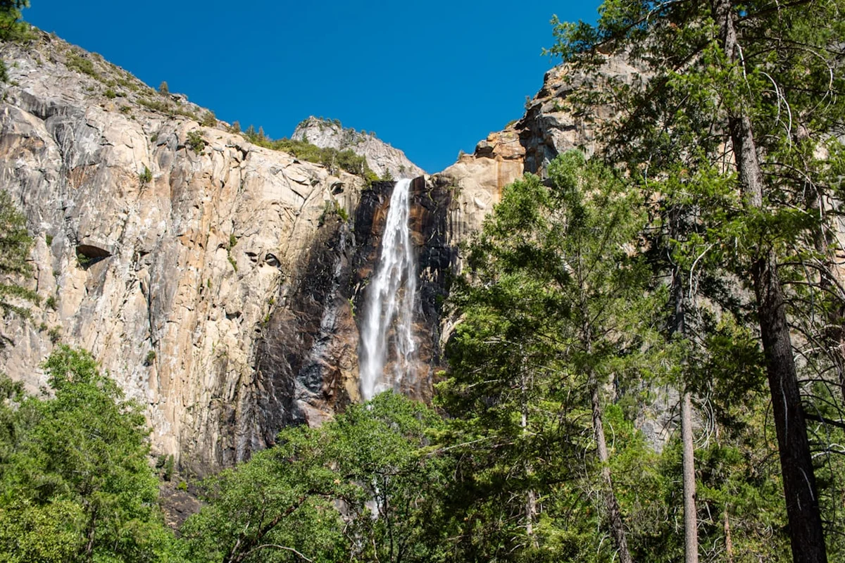
The Havasu Falls hike is a masterclass in contrast. The journey begins at Hualapai Hilltop, a remote precipice overlooking a vast, seemingly desolate canyon system. For the first 13 kilometres, hikers descend through a dry, winding arroyo where the scale of the Grand Canyon's geology is on full display. The red rock walls rise higher with every step, creating a sense of profound isolation. The environment is classic high-desert: rugged, dusty, and exposed to the relentless Arizona sun. However, as the trail approaches the village of Supai, the sound of rushing water begins to echo through the canyon, and the vegetation shifts from hardy cacti to lush cottonwood trees and vibrant ferns. This sudden transition into a riparian paradise is one of the most rewarding moments in world trekking.
The water of Havasu Creek is the defining feature of the experience. Its startling turquoise colour is the result of high concentrations of calcium carbonate and magnesium, which reflect light in a unique spectrum. Over centuries, these minerals have deposited to form intricate travertine terraces and dams, creating natural infinity pools that look more like a tropical lagoon than a desert canyon. The creek feeds five primary waterfalls: Fifty-Foot Falls, Lower Navajo Falls, Havasu Falls, Mooney Falls, and Beaver Falls. Each has its own distinct character, from the wide, cascading curtains of Navajo Falls to the sheer, 60-metre drop of Mooney Falls, which requires a thrilling descent down a series of chains and ladders carved into the cliff face.
Because the trail is located on tribal land, the experience is deeply intertwined with the culture and daily life of the Havasupai Tribe. Supai is the most remote community in the lower 48 United States, accessible only by foot, mule, or helicopter. There are no roads leading to the village, and all supplies—from mail to groceries—are transported via mule trains. This lack of modern infrastructure creates a "time-capsule" atmosphere, where the rhythm of life is dictated by the canyon's natural cycles. Hikers must respect the sovereignty of the Havasupai people, adhering to strict regulations regarding photography, alcohol, and environmental protection. The physical challenge of the 762-metre ascent back to the hilltop on the final day is a small price to pay for the privilege of witnessing one of the Earth's most extraordinary hidden wonders.
History and Cultural Context
The Havasupai Tribe has inhabited the Grand Canyon region for over 1,000 years. Historically, they were a semi-nomadic people who spent their summers farming the fertile floor of Havasu Canyon and their winters hunting and gathering on the surrounding plateau. Their name, Havasu 'Baaja, translates to "People of the Blue-Green Water," reflecting the spiritual and physical centrality of the creek to their identity. The water is considered a sacred life-force, and the canyon itself is a sanctuary that has protected the tribe from external pressures for centuries.
The late 19th century brought significant challenges to the Havasupai. In 1880, the United States government established a small reservation for the tribe, which initially consisted of only 518 acres in the bottom of the canyon. This restricted their traditional seasonal migrations and forced a transition to a more sedentary lifestyle. For nearly a century, the tribe fought a legal and political battle to regain their ancestral lands. In 1975, after decades of advocacy, President Gerald Ford signed legislation that expanded the Havasupai Reservation to 185,000 acres, including much of the plateau land they had historically utilised. This victory was a landmark moment for indigenous land rights in the United States.
Today, tourism is the primary economic driver for the Havasupai people. While the influx of thousands of visitors each year provides essential revenue for the community, it also presents challenges in terms of environmental management and cultural preservation. The tribe has taken significant steps to limit the impact of tourism, including a strict permit system and a ban on day hiking. The village of Supai remains a private residential area, and visitors are asked to pass through respectfully without loitering or taking photos of residents. The history of the canyon is also marked by natural events; massive flash floods in 2008 and 2022 significantly altered the landscape, destroying old waterfalls and creating new ones, serving as a reminder of the raw, transformative power of nature in this volatile environment.
Want more background? Read extended notes on history and cultural context → Learn more
Seasonal Highlights and Weather Reality
The Havasu Falls hike is subject to the extreme weather patterns of the American Southwest. Choosing the right time to visit is crucial for both safety and enjoyment. The trail is generally open from February through November, with each season offering a different experience.
Spring (March to May): This is arguably the best time to visit. Temperatures in the canyon are pleasant, typically ranging from 20°C to 28°C during the day, making the long hike in and out much more manageable. The water temperature is cool but refreshing, and the desert flora is often in bloom. However, this is also the most competitive time for permits, and the trail can feel crowded.
Summer (June to August): Summer in the canyon is brutally hot, with temperatures frequently exceeding 40°C. Hiking during the middle of the day is dangerous and often prohibited by the tribe to prevent heatstroke. Furthermore, July and August mark the "monsoon season" in Arizona. Sudden, violent thunderstorms can cause catastrophic flash floods in the narrow canyons. If a flood warning is issued, hikers must evacuate to higher ground immediately. While the water is warmest for swimming in summer, the risk of floods and extreme heat makes this a challenging season for many.
Autumn (September to November): As the summer heat fades, September and October offer a second "sweet spot" for hikers. The water remains warm enough for swimming, and the risk of monsoons decreases. The cottonwood trees begin to turn a brilliant gold in late October and November, providing a stunning contrast against the red canyon walls. Night-time temperatures can drop significantly, often reaching near freezing by late November.
Winter (December to January): The tribe typically closes the canyon to tourists during the winter months to allow the land and the community to rest. Temperatures can be quite cold, and snow is not uncommon at the Hualapai Hilltop trailhead (1,585 m elevation).
Recommended Itinerary
3-Day Havasu Falls Itinerary
Day 1: Hualapai Hilltop to Havasupai Campground
- Distance: 16 km
- Elevation loss: 762 m
- Time: 4–7 hours
- Start at dawn (5:00 AM or earlier) to avoid the heat of the day.
- Descend the "Switchbacks"—a steep 1.5 km section dropping 300 metres from the rim.
- Follow the dry wash for 11.5 km through the winding limestone and sandstone canyon.
- Arrive at the village of Supai (13 km mark). Check in at the Tourist Office to receive your wristbands.
- Continue 3 km past the village, passing Fifty-Foot Falls and Lower Navajo Falls.
- Witness the first view of Havasu Falls before entering the campground.
- Set up camp along Havasu Creek; the campground is 1.5 km long with sites on both sides of the water.
Day 2: Exploring the Waterfalls (Mooney and Beaver Falls)
- Distance: 8–12 km return (depending on exploration)
- Elevation: Moderate ups and downs, including technical cliff descent.
- Time: 5–8 hours
- Morning: Head to the northern end of the campground to find the descent to Mooney Falls.
- Navigate the "Chains and Ladders"—a steep, wet, and slippery descent through tunnels and down cliff faces (not for those with a fear of heights).
- Spend time at the base of Mooney Falls (60 m), the tallest in the canyon.
- Continue downstream 3.5 km to Beaver Falls. The trail involves multiple creek crossings and lush jungle-like vegetation.
- Beaver Falls features a series of terraced pools perfect for swimming and relaxing.
- Return to the campground by late afternoon to enjoy the sunset at Havasu Falls.
Day 3: The Ascent - Havasupai Campground to Hualapai Hilltop
- Distance: 16 km
- Elevation gain: 762 m
- Time: 5–8 hours
- Extremely early start recommended (3:00 AM or 4:00 AM) to complete the climb before the sun hits the canyon floor.
- Hike the 3 km back to Supai Village in the dark or twilight.
- Begin the long, steady 11.5 km trek through the canyon wash.
- The final 1.5 km (The Switchbacks) is the most difficult section, gaining 300 metres of elevation at the very end of the journey.
- Arrive back at Hualapai Hilltop; ensure you have plenty of water left for the final climb.
- Drive back to Peach Springs or onward to your next destination.
Important Notes:
- Day hiking is strictly prohibited; you must have a multi-night permit.
- Mule transport for bags must be booked months in advance and is expensive.
- The village of Supai is a residence; do not take photos of people or homes.
- Water is available at a natural spring in the campground (Fern Spring); treatment is recommended.
- All rubbish must be packed out; there are no bins in the campground.
- Alcohol and drugs are strictly forbidden on the reservation and carry heavy fines.
Planning and Bookings
Book Your Trip
Everything you need to plan your journey
Accommodation
Find places to stay near Peach Springs
Flights
Search flights to Peach Springs
Essential Preparation
Planning a trip to Havasu Falls requires meticulous coordination, often starting a full year in advance. The most critical step is securing a permit through the official Havasupai Reservations website. Because the hike is located on a remote Indian Reservation, logistics are more complex than a standard national park visit. You must base yourself in or near Peach Springs, Arizona, the night before your hike. Peach Springs is the headquarters of the Hualapai Nation and the closest town to the trailhead, located approximately 100 kilometres (a 1.5-hour drive) from Hualapai Hilltop.
Physical preparation is equally essential. While the 16 km distance might seem manageable, the combination of heavy packs, extreme heat, and the final 762-metre ascent makes this a strenuous undertaking. Hikers should train with a weighted pack on similar elevation gradients. Additionally, ensure your travel insurance covers remote medical evacuation, as a helicopter rescue from the canyon floor can cost upwards of US$5,000.
Trail Accommodation
There are only two options for staying overnight within the reservation: the Havasupai Campground or the Havasupai Lodge. Both require reservations made well in advance.
Havasupai Campground: This is a primitive camping area located between Havasu Falls and Mooney Falls. It is a "choose your own site" system along a 1.5 km stretch of the creek.
- Facilities: Composting toilets are located at intervals throughout the camp. There are no showers.
- Water: Fern Spring provides fresh water, but it should be filtered or treated.
- What's NOT provided: No picnic tables, no fire rings (fires are banned), and no rubbish bins.
- Cost: Included in the permit price (typically US$300–$450 per person for a 3-night stay).
Havasupai Lodge: Located in the village of Supai, 3 km from the waterfalls. This is a basic motel-style accommodation for those who do not wish to camp.
- Facilities: Two double beds, private bathroom, and air conditioning.
- Availability: Extremely limited and often sells out within minutes of opening.
- Note: Staying at the lodge still requires a permit, and you must still hike 3 km each way to see the main falls.
Required Gear
- Hiking Boots: Sturdy, waterproof boots with excellent traction. The descent to Mooney Falls is slippery and requires a firm grip.
- Backpack: 50–65L for campers, or a 20–30L daypack for lodge guests. Ensure it has a high-quality hip belt.
- Water Storage: Minimum 3–4 litres of carrying capacity. Hydration bladders are highly recommended.
- Navigation: While the trail is well-defined, an offline GPS map (like AllTrails or Gaia) is useful for tracking progress in the heat.
- Headlamp: Essential for early morning starts and navigating the campground at night.
- Trekking Poles: Highly recommended for the steep switchbacks to save your knees on the descent and provide stability on the ascent.
What to Bring
- Food: All meals for the duration of your stay. High-calorie, lightweight options like dehydrated meals, nuts, and energy bars are best. There is a small store in Supai, but prices are very high and stock is inconsistent.
- Water Treatment: A lightweight filter (like a Sawyer Squeeze) or purification tablets for water from Fern Spring.
- Cooling Gear: A cooling towel or "buff" to soak in the creek and wear around your neck during the hike.
- Sun Protection: SPF 50+ sunscreen, a wide-brimmed hat, and UV-rated sunglasses. The canyon offers very little shade.
- First Aid: Blister kits (moleskin/Leukotape), electrolyte salts, ibuprofen, and any personal medications.
- Water Shoes: Sturdy sandals (like Tevas or Chacos) for creek crossings and swimming in the travertine pools.
Permits
The permit system for Havasu Falls is one of the most competitive in the world. The Havasupai Tribe limits the number of visitors to protect the environment and the privacy of the community. Permits are sold as a fixed 3-night/4-day package; shorter stays are not permitted, though you may choose to leave early.
The Booking Process:
- Reservations typically open on February 1st each year at 8:00 AM Arizona Time on the official Havasupai Reservations website.
- You must create an account on the website prior to the opening date.
- Be prepared for the website to experience high traffic; permits for the entire year often sell out within hours.
- A "Cancellations/Transfer" page on the official site allows users to purchase permits that others have given up throughout the season. This is often the only way to secure a spot if you miss the February 1st opening.
Costs and Regulations:
- Permit prices are subject to change but generally range from US$375 to US$455 per person for the 3-night stay. This includes all tribal fees and environmental taxes.
- Permits are non-refundable. They can only be transferred through the official website's transfer system.
- You must bring a printed copy of your confirmation and a valid photo ID to check in at the Tourist Office in Supai (or the designated check-in point in Peach Springs, depending on current tribal rules).
- Wristbands must be worn at all times while on the reservation. Rangers frequently check for permits along the trail and at the waterfalls.
Mule and Helicopter Transport:
- Mule transport for luggage must be reserved in advance. Each mule can carry up to four bags (max 14 kg each). This service is expensive (approx. US$400 round trip) and must be booked through the same official portal.
- Helicopter transport is available on specific days (usually Monday, Thursday, Friday, and Sunday). It operates on a first-come, first-served basis, with tribal members receiving priority. The cost is approximately US$100 per person each way. Note that waiting times can exceed 5 hours, and flights are often cancelled due to wind.
Other Activities in the Area
Since the journey to Havasu Falls requires travelling to a remote part of Arizona, many hikers combine the trip with other regional attractions:
- Grand Canyon South Rim: Located about 3 hours from Peach Springs, the South Rim offers the classic "big" views of the canyon, with developed facilities and numerous hiking trails like Bright Angel and South Kaibab.
- Route 66: Peach Springs is located on the historic "Mother Road." Visit Seligman (the inspiration for the movie 'Cars') or Kingman to experience vintage Americana, neon signs, and classic diners.
- Grand Canyon Caverns: Located just outside Peach Springs, these are the largest dry caverns in the United States. You can take a guided tour 60 metres underground or even stay in an underground suite.
- Skywalk at Eagle Point: Managed by the Hualapai Tribe at Grand Canyon West, this glass-bottomed bridge extends 21 metres over the rim of the canyon. It is about a 2-hour drive from Peach Springs.
- Seligman to Kingman Drive: This stretch of Route 66 is one of the longest remaining continuous sections of the original highway, offering beautiful desert scenery and quirky roadside stops.
Safety and Conditions
Heat and Hydration: The single greatest danger on the Havasu Falls hike is heat exhaustion. Temperatures on the canyon floor can be 10°C higher than at the rim. There is no water available between Hualapai Hilltop and Supai Village (13 km). You must carry at least 4 litres of water for the hike in and out. Drink before you are thirsty and supplement with electrolytes to prevent hyponatremia. Avoid hiking between 10:00 AM and 4:00 PM during the summer months.
Flash Floods: Havasu Canyon is a narrow drainage system. Rain falling many kilometres away can cause a wall of water to rush through the canyon with little warning. If you see the water turn brown or muddy, or hear a sound like a freight train, climb to high ground immediately. Do not attempt to cross the creek during a flood. The tribe will often evacuate the campground if a serious threat is detected.
The Mooney Falls Descent: The path to the base of Mooney Falls is technically challenging. It involves descending through two narrow tunnels and then down a vertical cliff face using chains, bolts, and wooden ladders. The rock is constantly misted by the waterfall, making it extremely slippery. Wear gloves for a better grip on the chains and take your time. This section is not recommended for small children or those with severe vertigo.
Mule Train Etiquette: You will frequently encounter mule trains carrying supplies or luggage. Mules always have the right of way. When you hear them approaching, move to the "inside" of the trail (the side against the canyon wall, not the cliff edge) and stand perfectly still until the entire train has passed. Do not attempt to pet or feed the mules, as they are working animals and can be unpredictable.
Emergency Services: There is a small clinic in Supai Village for basic medical needs, but it is not equipped for major trauma. In the event of a serious injury, a helicopter evacuation is the only option. Ensure you have a way to communicate; while there is no mobile signal in the canyon, a satellite messenger (like a Garmin inReach) can be a lifesaver.
Side Trips and Points of Interest
Beaver Falls: Located 3.5 km downstream from Mooney Falls, Beaver Falls is a series of cascading travertine terraces. The hike to Beaver is an adventure in itself, involving several creek crossings and sections where you must navigate through thick grapevines and over small ladders. The pools here are wide and deep, offering some of the best swimming in the canyon. Look for the "Palm Tree" (a lone palm growing in the canyon) as a landmark along the way.
The Confluence: For the truly adventurous and fit, it is possible to hike all the way to the confluence of Havasu Creek and the Colorado River. This is a 26 km round trip from the campground and should only be attempted by experienced hikers who start at first light. The sight of the bright turquoise Havasu water mixing with the deep green or brown of the Colorado River is a spectacular geological phenomenon.
Fifty-Foot Falls and Lower Navajo Falls: These falls are often overlooked as hikers rush toward the campground, but they are stunning in their own right. Located between the village and the campground, they were significantly reshaped by the 2008 flood. They offer a more tranquil experience with fewer crowds than Havasu Falls.
Rock Formations (Wigleeva): Above the village of Supai, two large rock pillars known as Wigleeva stand guard. According to Havasupai legend, these pillars represent a man and a woman of the tribe. It is said that if the pillars ever fall, the canyon walls will close in and the Havasupai people will be no more. They are a significant cultural landmark and can be seen from various points around the village.
Leave No Trace
The Havasupai Reservation is a sovereign nation and a fragile ecosystem. The tribe has struggled with the environmental impact of tourism, and it is the responsibility of every visitor to minimise their footprint. Failure to follow Leave No Trace principles can lead to fines or expulsion from the reservation.
Core Principles for Havasu Canyon:
- Pack It In, Pack It Out: This is the most important rule. There is no rubbish collection in the campground. Every piece of trash, including food scraps, orange peels, and hygiene products, must be carried back up the 16 km trail to the hilltop. Do not leave gear (tents, chairs, coolers) behind for others; it simply becomes litter that the tribe must fly out by helicopter.
- Respect the Water: Do not use soap (even biodegradable soap) directly in the creek. Wash yourself and your dishes at least 60 metres away from the water source. Avoid wearing sunscreen or bug spray into the pools if possible, as the chemicals can harm the delicate aquatic ecosystem.
- Stay on Designated Trails: The travertine formations are extremely fragile. Stepping on them can break structures that took hundreds of years to form. Use established paths to access the water.
- No Drones or Professional Filming: Drones are strictly prohibited on the reservation. They disturb the peace of the canyon and are disrespectful to the local community. Professional photography and filming require a special permit from the tribal council.
- Respect the Community: Supai is a living village, not a tourist attraction. Do not take photos of the residents, their children, or their homes. Keep noise levels low, especially when passing through the village early in the morning.