Hardergrat Trail - The Knife-Edge of the Bernese Oberland
The Hardergrat Trail is widely regarded as one of the most spectacular, demanding, and visually arresting ridge walks in the world. Stretching approximately 26.4 kilometres along the narrow limestone spine that separates the turquoise waters of Lake Brienz from the lush valleys of the Bernese Oberland, this trail is a test of physical endurance, mental fortitude, and technical precision. Unlike many alpine routes that offer occasional vistas, the Hardergrat provides a relentless, 360-degree panorama of the Swiss Alps, including the iconic Eiger, Mönch, and Jungfrau massifs to the south, and the deep, shimmering expanse of the lake 1,500 metres directly below to the north. This is not a journey for the faint-hearted; it is a high-altitude odyssey across a "knife-edge" ridge where the path is often no wider than a metre, with sheer grassy slopes and rocky precipices falling away on either side. For those with the requisite fitness and a head for heights, it represents the pinnacle of Swiss mountain hiking—a pure, unadulterated connection between earth and sky.
- Distance: 26.4 km point-to-point
- Elevation Gain: 2,280 m (total ascent); ~2,600 m (total descent)
- Duration: 9–12 hours (highly dependent on fitness and conditions)
- Difficulty: Very Challenging / T4–T5 on the SAC Scale
- Highest Point: Brienzer Rothorn (2,350 m)
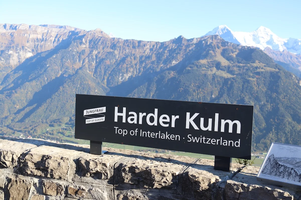
- Trailhead: Harder Kulm (accessible via funicular from Interlaken)
- End Point: Brienzer Rothorn (accessible via steam cog railway to Brienz)
- Best Time: June to October (strictly snow-free conditions only)
Overview
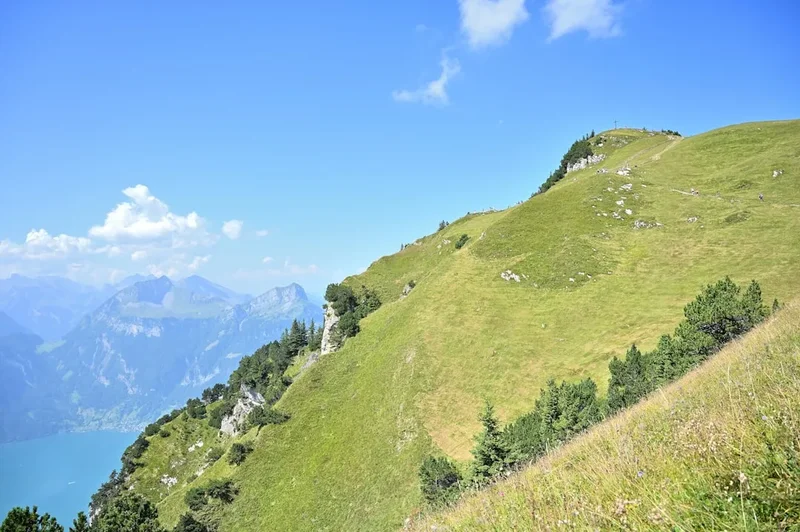
The Hardergrat Trail is a masterclass in alpine minimalism. There are no huts along the ridge, no water sources, and very few "escape routes" once you have committed to the central section. The trail follows the natural crest of the mountain range, undulating over a series of peaks including the Suggiture, Augstmatthorn, Schnierenhirel, and the formidable Tannhorn. The terrain is a complex mix of narrow dirt single-track, steep grassy slopes (which can be treacherous when damp), and technical limestone scrambling. While the path is generally well-defined, the sheer exposure is the defining characteristic of the experience. In many sections, a single misstep could lead to a fall of hundreds of metres, making concentration as vital as cardiovascular capacity.
Physically, the Hardergrat is a "beast" of a day hike. While the net elevation gain is 2,280 metres, the constant "rollercoaster" nature of the ridge means the cumulative effort feels significantly greater. Hikers must maintain a steady pace to catch the final train down from Brienzer Rothorn, adding a layer of time-pressure to an already strenuous day. Most experienced hikers begin their journey in the pre-dawn darkness, often starting from Interlaken on foot or taking the first funicular to Harder Kulm to maximise daylight. The reward for this exertion is unparalleled: a front-row seat to the sunrise over the High Alps and a sense of isolation that is rare in the heavily developed tourist regions of Switzerland.
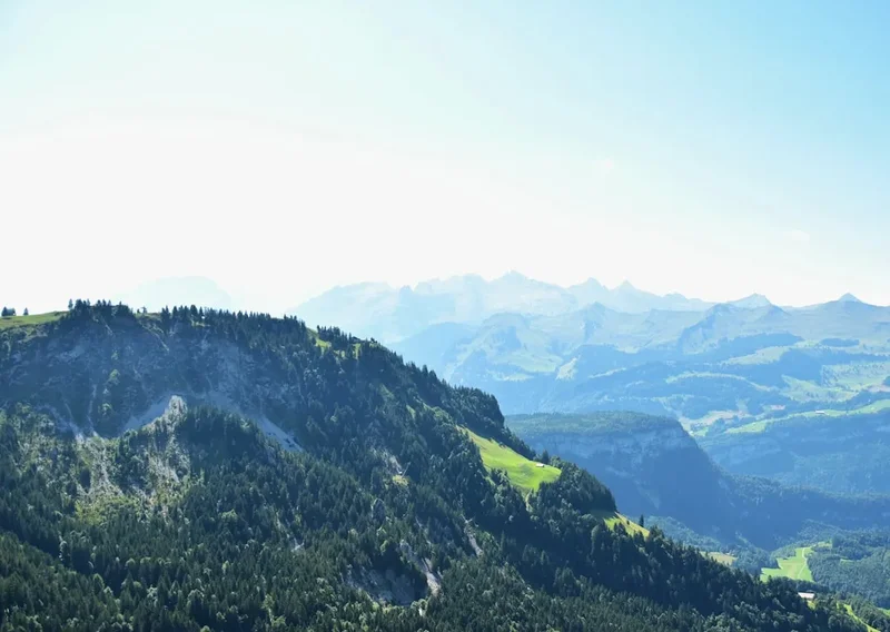
The landscape is a study in contrasts. To the north, the ridge drops precipitously into the shadows of the Brienz valley, where the lake's unique glacial silt gives it a brilliant, opaque turquoise hue. To the south, the sun-drenched slopes of the Grindelwald and Lauterbrunnen valleys lead the eye toward the permanent glaciers of the 4,000-metre peaks. The ridge itself is a sanctuary for alpine wildlife, most notably the large colonies of Alpine Ibex (Steinbock) that frequent the slopes around Augstmatthorn. Walking the Hardergrat is not merely a hike; it is a high-stakes aerial traverse that demands total respect for the mountain environment.
History and Cultural Context
The Hardergrat has existed for centuries as a series of disconnected goat paths and hunter trails used by local inhabitants of the Brienz and Interlaken regions. Historically, the ridge served as a natural boundary between alpine pastures. However, it wasn't until the late 19th and early 20th centuries, with the rise of Swiss alpinism and the development of mountain tourism, that the ridge began to be seen as a recreational objective. The opening of the Harder Kulm funicular in 1908 and the Brienzer Rothorn steam railway in 1892 provided the "bookends" that made a traverse of the entire ridge logistically feasible for the first time.
In recent decades, the Hardergrat has transitioned from a niche mountaineering route to a world-famous "bucket list" item, largely driven by the explosion of trail running and social media. Professional mountain runners like Kilian Jornet have brought international attention to the ridge, showcasing its aesthetic perfection and technical challenge. Despite its fame, the local authorities have intentionally kept the trail in a relatively "wild" state. Unlike many other popular Swiss peaks, you will not find extensive cable railings or artificial steps here. The trail remains a raw, natural challenge, reflecting the Swiss philosophy of personal responsibility in the mountains.
Culturally, the ridge is part of the Bernese Oberland's rich heritage of mountain farming. Even today, you may hear the distant chime of cowbells from the lower pastures (alps) where traditional cheesemaking continues during the summer months. The Augstmatthorn section is also a protected wildlife area, established to ensure the survival of the Alpine Ibex, which was once hunted to near extinction in Switzerland but has since made a triumphant return to these craggy heights.
Want more background? Read extended notes on history and cultural context → Learn more
Seasonal Highlights and Weather Reality
The window for a safe traverse of the Hardergrat is remarkably narrow. Due to its elevation and the steepness of the slopes, snow can linger well into June, and early autumn storms can bring fresh powder as early as September. Attempting the ridge when snow is present is extremely dangerous, as the narrow path becomes invisible and the steep grassy slopes become lethal slides.
Summer (July to August): This is the primary season. The days are long, and the trail is typically dry. However, summer brings two major challenges: heat and thunderstorms. Because the ridge is entirely exposed, there is no shade from the sun, and temperatures can feel much higher than the forecast suggests. More critically, the Hardergrat is a lightning magnet. If there is any forecast of afternoon thunderstorms, the ridge must be avoided. There is nowhere to hide from a lightning strike on a knife-edge limestone crest.
Autumn (September to October): Often considered the best time by locals. The air is crisper and clearer, providing better visibility of the distant peaks. The heat is less intense, and the ibex are often more active. However, the days are shorter, meaning an even earlier start is required to reach Brienzer Rothorn before the last train departs. Frost can also make the limestone sections slippery in the early morning.
Winter and Spring (November to June): The trail is effectively closed to all but expert winter mountaineers. The risk of avalanches on the steep flanks is high, and the technical difficulty increases exponentially. For the average hiker, the Hardergrat is a strictly summer-to-autumn endeavour.
Recommended Itinerary
Hardergrat Route Progression
Waypoint 1: Interlaken Ost to Harder Kulm
- Distance: 4 km (if walking) / 0 km (if taking funicular)
- Elevation gain: 750 m (if walking)
- Time: 1.5 hours (walking) / 10 minutes (funicular)
- Most hikers take the first funicular (usually 08:10 or 09:10) or start walking at 04:00 AM to beat the heat.
- Harder Kulm (1,322 m) offers the last easy access to water and toilets.
- The trail begins gently through a dense forest, providing a deceptive warm-up.
Waypoint 2: Harder Kulm to Augstmatthorn
- Distance: 10 km
- Elevation gain: 800 m
- Time: 3–4 hours
- The trail leaves the forest and gains the ridge properly at the Wannichnubel.
- Pass through the Suggiture (2,085 m), where the first real exposure begins.
- Arrive at Augstmatthorn (2,137 m), a popular turnaround point for day hikers.
- Keep a sharp eye out for the ibex colonies that frequent this summit.
- The views of Lake Brienz become truly dramatic here.
Waypoint 3: Augstmatthorn to Tannhorn (The Crux)
- Distance: 7 km
- Elevation gain: 500 m (with significant undulations)
- Time: 3–4 hours
- This is the most technical and mentally taxing section of the trail.
- The path narrows significantly; in some places, it is only 30–50 cm wide.
- Pass over the Schnierenhirel and several unnamed bumps on the ridge.
- The ascent to the Tannhorn (2,221 m) involves steep, loose limestone scrambling.
- The Tannhorn summit is extremely narrow—barely enough room for two people to sit comfortably.
- This section has no exit points; once you pass Augstmatthorn, you are committed to the ridge.
Waypoint 4: Tannhorn to Brienzer Rothorn
- Distance: 5.4 km
- Elevation gain: 230 m
- Time: 2–3 hours
- The ridge remains exposed but the technical difficulty slightly decreases after the Tannhorn.
- Pass the Eisee saddle, where a small lake is visible below to the north.
- The final climb to Brienzer Rothorn (2,350 m) is a steady grind on tired legs.
- Arrive at the Brienzer Rothorn mountain station, featuring a restaurant and the steam train terminus.
- Ensure you arrive before the last train (usually around 16:30 or 17:30 depending on the season).
Important Notes:
- There is NO water available on the ridge between Harder Kulm and Brienzer Rothorn.
- The trail is a "no-fall" zone in many sections; focus is paramount.
- If you miss the last train at Brienzer Rothorn, you face a further 1,500 m descent on foot to Brienz (approx. 3 hours).
- Mobile signal is generally good along the ridge but can be spotty in the gullies.
Planning and Bookings
Book Your Trip
Everything you need to plan your journey
Accommodation
Find places to stay near Interlaken
Flights
Search flights to Interlaken
Essential Preparation
The Hardergrat is not a trail you "stumble" onto. It requires meticulous planning. The primary constraint is the lack of water and the strict timing of the mountain transport. You must be in peak physical condition; if you cannot comfortably hike 2,000+ metres of elevation in a single day, the Hardergrat will be a miserable and potentially dangerous experience. Training should focus on steep ascents, descents, and "stair-master" style endurance.
Logistically, you should base yourself in Interlaken the night before. Check the weather forecast using the MeteoSwiss app—specifically looking for wind speeds and thunderstorm probability. If winds are predicted above 40 km/h, the ridge can be dangerous. Coordinate your start time with the Brienzer Rothorn train schedule. Many fast hikers start at 05:00 AM from Interlaken to ensure they have a 12-hour window to reach the end.
Trail Accommodation
This is a day hike requiring no overnight accommodation on the trail itself. Camping is strictly prohibited along the Hardergrat ridge, as much of it falls within a protected wildlife zone (Jagdbanngebiet). However, there are options at either end:
Interlaken (Start): A wide range of hostels, hotels, and campsites. Recommended for the night before your hike.
Brienzer Rothorn (End): The Berghaus Rothorn Kulm offers limited hotel rooms and dormitory-style accommodation. Booking a night here after your hike is an excellent way to recover and enjoy the sunset without rushing for the last train. Facilities include a restaurant, toilets, and showers for overnight guests. Prices range from 80 CHF to 150 CHF per night including breakfast.
Required Gear
- Footwear: High-quality trail running shoes or lightweight mountain boots with aggressive tread (Vibram or similar). Grip on dry grass and loose limestone is essential.
- Trekking Poles: Highly recommended. They provide vital stability on the narrow ridge and save your knees on the steep descents. Ensure they are collapsible for the scrambling sections.
- Clothing: A layering system is vital. Even in summer, the ridge is windy and can be cold. Bring a windproof/waterproof shell, a lightweight fleece, and moisture-wicking base layers.
- Sun Protection: High-SPF sunscreen, a hat, and quality sunglasses. There is zero shade for 10+ hours.
- Navigation: A GPS-enabled watch or smartphone with offline maps (e.g., Outdooractive or SwissTopo). While the ridge is obvious, cloud cover can disorient you.
- Emergency Kit: A basic first aid kit, an emergency bivy bag or space blanket, and a whistle.
What to Bring
- Water: Minimum 3–4 litres per person. There are no refills. In hot weather, 5 litres may be necessary. Consider using an electrolyte powder to prevent cramping.
- Food: High-calorie, easily digestible snacks. Think nuts, energy bars, dried fruit, and sandwiches. You will burn 4,000–6,000 calories on this trek.
- Personal Items: Tissues, hand sanitiser, and a small bag for your rubbish (pack it out).
- Cash/Cards: For the funicular at the start and the train/restaurant at the end. The Brienzer Rothorn train is approximately 60–90 CHF (half-fare with Swiss Travel Pass).
- Headlamp: Essential for the early morning start or in case you are delayed and finish in the dark.
Permits
No permits are required to hike the Hardergrat Trail. It is a public right-of-way. However, you must adhere to the regulations of the Federal Game Reserve (Eidgenössisches Jagdbanngebiet) which covers much of the ridge. This means staying on the marked path, keeping dogs on a lead, and strictly no wild camping or drones.
Transport Costs: While the trail is free, the logistics are not. Budget for the following (prices are approximate and subject to change):
- Harder Kulm Funicular (One-way): ~20 CHF
- Brienzer Rothorn Steam Train (One-way to Brienz): ~60 CHF
- Train from Brienz back to Interlaken Ost: ~8 CHF
- Note: Holders of the Swiss Travel Pass or Half-Fare Card receive a 50% discount on most of these services.
Check-in: It is highly recommended to tell your accommodation or a friend your intended route and expected finish time. There is no formal check-in system, but the "no-exit" nature of the trail makes it important that someone knows you are out there.
Other Activities in the Area
The Interlaken and Brienz regions offer a wealth of activities for those looking to recover or explore further:
- Lake Brienz Boat Cruise: A relaxing way to see the ridge you just walked from a completely different perspective. The deep blue water is incredibly soothing for tired legs.
- Paragliding in Interlaken: If the ridge didn't give you enough of a height fix, Interlaken is the paragliding capital of Switzerland. You can soar over the town with views of the Eiger.
- Giessbach Falls: A stunning series of waterfalls on the south side of Lake Brienz, accessible by boat and a historic funicular.
- Ballenberg Open-Air Museum: Located near Brienz, this museum features over 100 original, centuries-old buildings from all over Switzerland.
- Aare Gorge (Aareschlucht): A dramatic limestone gorge near Meiringen, easily accessible by train from Brienz.
Safety and Conditions
The "No-Fall" Reality: The Hardergrat is not technically "climbing," but it is "exposed scrambling." In many sections, the ground drops away at 60–70 degrees on both sides. A slip on wet grass or a trip over a loose rock can be fatal. You must have "sure-footedness"—the ability to place your feet accurately and confidently without hesitation.
Vertigo: If you suffer from acrophobia or significant vertigo, do not attempt this trail. The exposure is constant for nearly 20 kilometres. There is no "easy" way off the ridge once you are past the Augstmatthorn; the few side trails that exist are extremely steep and often poorly maintained.
Weather Hazards:
- Lightning: As mentioned, the ridge is the highest point for miles. If a storm approaches, you are the lightning rod. Check the "Search.ch" or "MeteoSwiss" radar frequently.
- Wind: High winds can literally blow you off the narrow sections of the ridge. Gusts are often stronger on the crest than in the valleys.
- Heatstroke: With no shade and high exertion, heat exhaustion is a real risk. Drink regularly even if you don't feel thirsty.
Emergency Protocol: In Switzerland, the emergency number for mountain rescue (REGA) is 1414. For general emergencies, dial 112. Ensure your phone is fully charged and consider carrying a power bank. Because of the ridge's prominence, you will likely have a line-of-sight to mobile towers, but don't rely on it in the deep notches between peaks.
Side Trips and Points of Interest
Augstmatthorn Ibex Colony: One of the most reliable places in Switzerland to see Alpine Ibex. These majestic creatures are surprisingly unfazed by humans and often graze just metres from the trail. Remember to keep a respectful distance and never feed them.
The Tannhorn Summit: The literal and figurative high point of the technical challenge. Standing on the summit of the Tannhorn is a profound experience; the ridge is so narrow here that you feel as though you are standing on the roof of the world. The 360-degree view includes the entire length of the ridge you have traversed and the daunting section still to come.
Brienzer Rothorn Steam Railway: Even if you aren't a "train person," the descent from the finish line is spectacular. This is the only steam-powered cog railway in Switzerland that operates daily in the summer. The sight of the red locomotives chuffing through alpine tunnels and over stone bridges is the perfect end to a monumental day.
Suggiture: A smaller peak before Augstmatthorn that offers a fantastic "preview" of the exposure to come. It’s a great place to check your nerves; if you feel uncomfortable here, it is wise to turn back, as the exposure only increases further along the ridge.
Leave No Trace
The Hardergrat passes through a fragile alpine ecosystem and a protected wildlife zone. It is our collective responsibility to ensure it remains pristine.
- Stay on the Trail: The thin alpine soil is easily eroded. Cutting switchbacks or walking off-trail destroys vegetation that takes years to grow back.
- Pack It Out: There are no bins on the ridge. This includes organic waste like banana peels or apple cores, which decompose very slowly at high altitudes and can be harmful to local wildlife.
- Respect the Ibex: Do not use drones, as they cause significant stress to the ibex and birds of prey. Keep noise to a minimum.
- No Wild Camping: Use the designated accommodation in the valleys or at the Brienzer Rothorn. Wild camping in the Jagdbanngebiet can result in heavy fines.
- Human Waste: With no toilets for 10 hours, you may need to go. Move at least 50 metres from the trail and water sources (though there are none), dig a small hole, and pack out your toilet paper in a sealed bag.