Hardangervidda Trek - Crossing the Roof of Norway
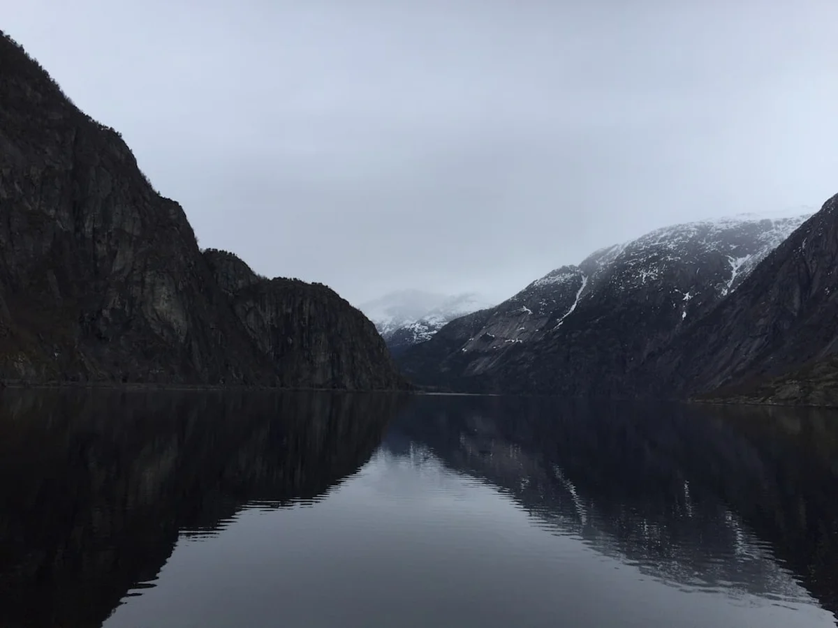
The Hardangervidda Trek is a journey across Europe’s largest high-mountain plateau, a vast and ancient wilderness that defines the rugged heart of Southern Norway. Spanning approximately 122.8 kilometres on this specific six-day route, the trek traverses a landscape of haunting beauty—a treeless expanse of arctic tundra, shimmering alpine lakes, and granite peaks that rise like silent sentinels over the horizon. Starting from the lush, waterfall-heavy valley of Kinsarvik on the edge of the Hardangerfjord and climbing onto the massive peneplain, walkers experience a profound transition from fjord-side greenery to a stark, windswept world that remains snow-covered for much of the year. This is not merely a hike; it is an immersion into a prehistoric landscape where wild reindeer herds roam and the weather dictates the rhythm of the day. With a total elevation gain of 2,724 metres, the route demands physical resilience and navigational competence, rewarding those who venture here with a sense of solitude and scale that is increasingly rare in the modern world.
- Distance: 122.8 km point-to-point
- Duration: 6 days
- Season: July and August (prime window; snow persists into June and returns in September)
- Accommodation: DNT (Norwegian Trekking Association) staffed and self-service huts, or wild camping
- Highest point: Approximately 1,450 m (near Hårteigen)
- Difficulty: Challenging (due to distance, weather variability, and rugged terrain)
- Closest City: Bergen (3-4 hours by public transport)
- Direction: West to East (Kinsarvik to Halne)
Overview
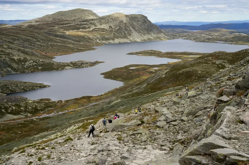
The Hardangervidda National Park covers 3,422 square kilometres, making it Norway's largest national park and a vital sanctuary for the largest wild reindeer herds in Europe. Geologically, the plateau is a "peneplain"—a vast area of land that has been eroded by glaciers and time into a relatively level surface, though "level" is a deceptive term for the hiker. While the horizon may appear flat from a distance, the terrain is a complex tapestry of rolling ridges, boggy depressions, boulder fields, and intricate river systems. The trek begins with a dramatic ascent through the Husedalen Valley, famous for its four massive waterfalls, before emerging onto the plateau proper. Once atop the "Vidda," the landscape opens into an immense, treeless sky-world where the air is exceptionally clear and the light takes on a crystalline quality.
Walking the Hardangervidda is an exercise in atmospheric immersion. The plateau sits above the tree line, meaning walkers are exposed to the elements at all times. In clear weather, the views are infinite, stretching across the plateau to the distinctive, hat-shaped peak of Hårteigen, which serves as a navigational beacon for days. In the mist or rain—which are frequent visitors—the landscape becomes ethereal and mysterious, requiring careful attention to the red "T" markings that define the Norwegian trekking network. The ecosystem here is fragile arctic-alpine tundra; mosses, lichens, and hardy shrubs like dwarf birch and willow are the primary flora, providing a minimalist backdrop to the dramatic sky.
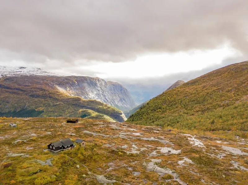
The infrastructure of the trek is supported by the Den Norske Turistforening (DNT), an organisation that maintains a world-class network of huts. These huts range from fully staffed lodges offering three-course meals to remote, self-service cabins where hikers cook their own food from a stocked pantry. This system allows for a unique "light" trekking experience, though many choose to carry tents to take advantage of Norway’s "Allemannsretten" (Right to Roam), which permits wild camping almost anywhere in the wilderness. Whether staying in huts or under canvas, the Hardangervidda offers a profound connection to the wild, where the only sounds are the wind, the cry of a golden plover, and the crunch of boots on ancient stone.
Wakahi Guide
Detailed route notes, maps, logistics & tips for the Hardangervidda Trek (PDF).
History and Cultural Context
The Hardangervidda has been a vital landscape for Norwegians for over 8,000 years. Following the retreat of the great glaciers at the end of the last Ice Age, nomadic hunters followed the migrating reindeer onto the plateau. Archaeologists have discovered hundreds of Stone Age sites, including pitfall traps and stone tool workshops, proving that this seemingly inhospitable environment was once a productive hunting ground. For the local farming communities in the surrounding fjords, the plateau served as essential summer pasture (seter) for sheep and cattle, a tradition that continues in some areas today. The ancient tracks used by these farmers and hunters form the basis of many of the modern hiking trails.
In more recent history, the Hardangervidda played a pivotal role during World War II. The plateau’s isolation and harsh conditions made it an ideal base for the Norwegian Resistance. Most famously, it was the staging ground for the "Heroes of Telemark"—saboteurs who crossed the frozen plateau in the winter of 1943 to destroy the heavy water plant at Vemork, successfully thwarting Nazi efforts to develop an atomic bomb. The endurance required for their mission remains a point of national pride and a testament to the plateau's formidable nature. Hikers today can still find traces of this history, from old stone shelters to the stories preserved in the DNT huts.
Culturally, the Hardangervidda is deeply embedded in the Norwegian psyche as the epitome of "Friluftsliv"—the philosophy of outdoor life. It is a place where Norwegians go to reconnect with their heritage and the raw power of nature. The plateau is also the ancestral home of the wild reindeer (Rangifer tarandus tarandus). Unlike the semi-domesticated herds found in Northern Norway, these are truly wild animals, and their presence is a reminder of the plateau's status as a pristine ecosystem. Protecting their migration routes and calving grounds is a primary focus of the national park's management, and hikers are encouraged to view the landscape through the lens of conservation and respect for these ancient inhabitants.
Want more background? Read extended notes on history and cultural context → Learn more
Seasonal Highlights and Weather Reality
The hiking season on the Hardangervidda is remarkably short, typically spanning from early July to late August. Outside of this window, the plateau is a winter environment. Even in June, many of the higher passes and northern slopes remain buried under deep snow, and the rivers are swollen with icy meltwater, making crossings dangerous or impossible. By September, the first autumn storms arrive, often bringing snow and sub-zero temperatures that can catch unprepared hikers off guard.
July: This is the month of the "midnight sun" (or near-constant daylight). The plateau erupts in a brief but intense flowering season. Snow patches still dot the landscape, providing a beautiful contrast against the dark rock and blue lakes. However, this is also the peak season for mosquitoes and midges, particularly in boggy areas. Hikers should be prepared for wet feet as the ground is often saturated with meltwater.
August: Generally considered the best month for trekking. The ground has dried out significantly, the insect population begins to dwindle, and the weather is often more stable. The berries—blueberries, crowberries, and the prized "mountain gold" or cloudberries—begin to ripen. The nights become darker and cooler, offering a chance to see the stars or even the first hints of the Aurora Borealis late in the month.
Weather Reality: Regardless of the month, the Hardangervidda creates its own weather. It is not uncommon to experience "four seasons in one day." A sunny morning can transform into a freezing rainstorm with gale-force winds by midday. Temperatures on the plateau rarely exceed 15°C and can drop to near freezing even in mid-summer. Fog is a significant hazard; when the clouds descend, the plateau becomes a featureless world where navigation becomes extremely difficult. High-quality waterproofs and a solid understanding of map and compass are non-negotiable requirements for any season.
Recommended Itinerary
6-Day Hardangervidda West-to-East Itinerary
Day 1: Kinsarvik to Stavali
- Distance: 15.2 km
- Elevation gain: 1,100 m
- Time: 6–8 hours
- Start at the trailhead in Kinsarvik, near the Hardangerfjord
- Ascend the Husedalen Valley, passing four spectacular waterfalls: Tveitafossen, Nyastølsfossen, Nykkjesøyfossen, and Søtefossen
- The trail is steep and rocky, climbing from sea level to the plateau edge
- Pass through lush pine forest into the high-alpine zone
- Arrive at Stavali Hut (DNT self-service), situated in a rugged, rocky basin
- This is the most physically demanding day due to the sustained elevation gain
Day 2: Stavali to Hadlaskard
- Distance: 21.4 km
- Elevation gain: 450 m
- Time: 7–8 hours
- Enter the true plateau landscape—vast, open, and treeless
- Cross several small streams and navigate boulder-strewn terrain
- Pass the distinctive peak of Hårteigen in the distance (the "landmark of the Vidda")
- The trail follows a series of ridges and valleys with expansive views
- Arrive at Hadlaskard Hut (DNT self-service), a beautiful stone hut located in a grassy valley by the Veig River
- A long day that introduces the scale and solitude of the inner plateau
Day 3: Hadlaskard to Sandhaug
- Distance: 23.1 km
- Elevation gain: 350 m
- Time: 7–9 hours
- Continue east across the heart of the national park
- The terrain becomes flatter and more boggy, with numerous lakes and ponds
- Cross the river Veig (check bridge status or water levels)
- Keep a sharp eye out for wild reindeer herds, which frequent this central area
- Arrive at Sandhaug Hut (DNT staffed), a large lodge offering hot meals and showers
- Sandhaug is a central hub for the plateau and offers a touch of comfort mid-trek
Day 4: Sandhaug to Rauhelleren
- Distance: 24.5 km
- Elevation gain: 250 m
- Time: 7–9 hours
- A long but relatively flat day across the eastern part of the plateau
- The landscape is dominated by large lakes and low, rolling hills
- Pass through areas of dwarf birch and willow scrub
- The trail can be muddy in sections, requiring careful footwork
- Arrive at Rauhelleren Hut (DNT staffed), spectacularly situated on the shores of Lake Langesjøen
- Rauhelleren is famous for its hospitality and views of the surrounding peaks
Day 5: Rauhelleren to Heinseter
- Distance: 14.8 km
- Elevation gain: 200 m
- Time: 4–5 hours
- A shorter day allowing for recovery or exploration around the lakes
- The trail winds through a mosaic of water and rock
- Cross the river Hein via a bridge
- Arrive at Heinseter (Private/DNT-affiliated hut), a traditional mountain lodge
- The shorter distance provides a welcome break before the final push to the road
Day 6: Heinseter to Halne
- Distance: 23.8 km (or 14 km if using the Halne Fjellstugu boat)
- Elevation gain: 300 m
- Time: 5–7 hours
- The final stretch towards the Highway 7 (Riksvei 7)
- The terrain remains classic plateau tundra with wide horizons
- Option to walk the full distance to Halne Fjellstugu or take the seasonal boat across Lake Halnevatnet (check schedules)
- Finish at Halne Fjellstugu, located on the main road across the plateau
- Catch the bus (Nor-Way Bussekspress) back towards Bergen or Geilo
Important Notes:
- Distances are approximate and can feel longer due to terrain and weather
- DNT huts require a membership for the best rates and a standard key for self-service cabins
- River crossings can be challenging after heavy rain; always use bridges where available
- The route is marked with red "T"s on cairns, but these can be obscured by fog or snow
- Always carry a paper map and compass as backup to GPS
Planning and Bookings
Book Your Trip
Everything you need to plan your journey
Accommodation
Find places to stay near Bergen
Flights
Search flights to Bergen
Essential Preparation
The Hardangervidda is a serious mountain environment that requires a high level of physical fitness and self-sufficiency. Walkers should be comfortable carrying a 12–18 kg pack for 20+ kilometres a day over uneven, often boggy ground. Preparation should include cardiovascular training and several multi-day practice hikes with a full load. Navigational skills are paramount; you must be able to read a topographic map and use a compass in low-visibility conditions.
Logistically, the trek is best organised by starting in Bergen. From Bergen, you can take a bus or a combination of train (to Voss) and bus to Kinsarvik. The journey takes approximately 3–4 hours. At the end of the trek in Halne, the "Haukeliekspressen" or local buses connect back to Geilo (for the train to Bergen/Oslo) or directly back to Bergen. It is essential to check the bus schedules in advance, as they may only run once or twice a day. Joining the DNT (Norwegian Trekking Association) is highly recommended; it provides significant discounts on hut stays and access to the universal DNT key required for self-service huts.
Trail Accommodation
The DNT hut system is the backbone of trekking in Norway. On this route, you will encounter three types of accommodation:
Staffed Huts (e.g., Sandhaug, Rauhelleren): These are similar to mountain hotels. They provide dormitory or private room accommodation, serve three-course dinners, breakfast buffets, and offer packed lunches. They have showers (usually for a small fee) and drying rooms for wet gear. Staffed huts are generally open from late June to early September.
Self-Service Huts (e.g., Stavali, Hadlaskard): These are unstaffed but equipped with beds, pillows, and blankets (you must bring a silk or cotton liner). They have a fully stocked pantry where you can purchase food (tinned goods, pasta, oats) and a kitchen with gas stoves and cookware. You pay via a form or the DNT app. These huts require the standard DNT key.
Wild Camping: Under Norway’s "Allemannsretten," you can camp anywhere in the national park, provided you are at least 150 metres from inhabited buildings and leave no trace. This offers the ultimate freedom but requires carrying a tent, stove, and all food, significantly increasing pack weight.
Costs: Staffed huts cost approximately 800–1,100 NOK per night (including meals) for members. Self-service huts cost around 300–400 NOK per night for members. Non-members pay a higher rate.
Required Gear
- Hiking Boots: High-cut, waterproof leather or synthetic boots with a stiff sole. The terrain is rocky and often wet; ankle support is essential.
- Waterproof Jacket and Trousers: High-quality shell (Gore-Tex or similar) with taped seams. It must be able to withstand sustained heavy rain and high winds.
- Backpack: 50–70 litres with a waterproof cover and internal dry bags for clothing and sleeping bag.
- Navigation: Topographic map (1:50,000 scale), compass, and GPS (with offline maps). Do not rely solely on a phone.
- Sleeping Liner: Silk or cotton liner for hut use (mandatory). If camping, a 3-season sleeping bag (comfort rating 0°C to -5°C).
- First Aid Kit: Including blister plasters (Compeed), antiseptic, bandages, and personal medications.
- Head Torch: Even in the season of long days, a torch is necessary for hut use and emergencies.
- Emergency Shelter: A lightweight bivy bag or emergency foil blanket.
What to Bring
- Clothing Layers: Merino wool base layers (top and bottom), a fleece or wool mid-layer, and a lightweight down or synthetic insulated jacket for evenings. Avoid cotton.
- Food: If staying in staffed/self-service huts, you only need snacks and lunch for the first day. If camping, bring lightweight, high-calorie dehydrated meals, porridge, and energy bars.
- Water Treatment: While most stream water on the plateau is safe to drink, a lightweight filter or chlorine tablets are recommended near huts or reindeer grazing areas.
- Sun Protection: SPF 50+ sunscreen, lip balm with UV protection, and high-quality sunglasses (the glare from snow patches and lakes is intense).
- Insect Repellent: Strong repellent for mosquitoes and midges (DEET or Icaridin based). A head net can be a lifesaver in July.
- Toiletries: Biodegradable soap, travel towel, toothbrush, and toilet paper (pack out used paper if camping).
- Power Bank: To keep phones and GPS charged, as electricity is limited or unavailable in many huts.
Permits

One of the greatest joys of trekking in Norway is the lack of restrictive permits. There is no "entry permit" required to hike in Hardangervidda National Park. Access is governed by the "Allemannsretten" (the Right to Roam), a traditional right codified in the Outdoor Recreation Act of 1957. This allows everyone to enjoy the wilderness regardless of land ownership.
Hut Bookings: While you don't need a permit to walk, it is highly recommended to book your stay in staffed DNT huts in advance, especially during the peak weeks of late July and early August. You can book through the DNT website. For self-service huts, you cannot usually book a specific bed; the DNT policy is that "there is always room for one more," meaning no one is turned away, but you may end up sleeping on a mattress on the floor if the hut is full.
DNT Membership: While not a permit, a DNT membership is practically essential for anyone planning to stay in the huts. It provides a significant discount (often 25–50%) and is the only way to obtain the DNT key for self-service cabins. You can join online and have the membership card sent to your phone or pick up a physical card and key at DNT offices in Bergen or Oslo.
National Park Regulations:
- Reindeer Protection: It is strictly forbidden to disturb the wild reindeer. If you see a herd, keep a distance of at least 500 metres. If they notice you and move away, do not follow them.
- Fire Ban: There is a general ban on open fires in or near forests and other uncultivated land from 15 April to 15 September. Use a camping stove instead.
- Drones: The use of drones is generally prohibited in Norwegian National Parks to protect wildlife and the peace of other visitors.
- Fishing: If you plan to fish in the lakes, you must purchase a local fishing permit (fiskekort), which is often available at huts or online via Inatur.no.
Other Activities in the Area
The region surrounding the Hardangervidda offers some of Norway's most iconic landscapes and cultural experiences. Consider these additions to your trip:
- Trolltunga: Located near Odda, just south of Kinsarvik, this is one of Norway's most famous hikes. It can be done as a long day trip or integrated into a longer Hardangervidda crossing.
- Vøringsfossen: One of Norway's most spectacular waterfalls, with a total drop of 182 metres. It is easily accessible from Highway 7 near Eidfjord and features a dramatic new bridge over the falls.
- Hardangerfjord Fruit Trail: Before or after your hike, spend a day in the "Orchard of Norway." The area around Kinsarvik and Lofthus is famous for its cider and fruit production. Many farms offer tastings and sales from "honesty boxes."
- Flåm Railway: Often described as one of the most beautiful train journeys in the world, the Flåm line is a short distance from the northern edge of the plateau and can be reached via the Bergen Railway.
- Sea Kayaking: Explore the Hardangerfjord or the nearby Nærøyfjord (a UNESCO World Heritage site) from the water for a completely different perspective on the mountains.
- Bergen Sightseeing: Spend time in Norway's second city, visiting the historic Bryggen wharf, the fish market, and taking the Fløibanen funicular for views over the city and fjords.
Safety and Conditions
The Norwegian Mountain Code (Fjellvettreglene): All hikers in Norway should familiarise themselves with these nine rules, which are the foundation of mountain safety. Key points include: plan your trip and inform others, adapt the planned route according to ability and conditions, pay attention to weather forecasts, be equipped for bad weather and cold even on short trips, and turn back in time—there is no shame in retreating.
Navigation and Visibility: The Hardangervidda is notorious for "whiteouts" and thick fog. Because the terrain is so open and lacks prominent landmarks, it is incredibly easy to lose the trail. The red "T" markings are often painted on low rocks that can be covered by a light dusting of snow or obscured by mist. Always have a compass bearing ready and know how to follow it. If you lose the trail in the fog, the safest option is often to stay put and wait for visibility to improve rather than wandering further into the wilderness.
River Crossings: While the DNT maintains bridges on the main routes, smaller streams must be forded. During periods of heavy rain or rapid snowmelt, these can become dangerous. Never attempt to cross a river that is deeper than your knees or flowing too fast. Look for wider, shallower sections or wait for water levels to drop (often lower in the early morning). Keep your backpack waist belt unclipped during crossings so you can jettison the pack if you fall.
Hypothermia: This is a year-round risk on the plateau. Wet clothing combined with wind chill can lead to hypothermia even in temperatures well above freezing. Always carry a dry set of base layers in a waterproof bag and put on your shell layers before you get wet, not after. Recognise the "umbles" (stumbling, mumbling, fumbling, grumbling) as early signs of cold-related distress.
Emergency Contact: Mobile phone coverage is extremely spotty on the plateau. It may be available on high ridges but is non-existent in many valleys and huts. For emergencies, the international number is 112. Carrying a Personal Locator Beacon (PLB) or a satellite messenger (like a Garmin inReach) is highly recommended for solo hikers or those heading off the main trails.
Side Trips and Points of Interest
Hårteigen (1,690 m): This is the most iconic landmark on the Hardangervidda. Its flat-topped, square profile is visible from almost everywhere on the western plateau. A side trip to the summit is possible from the trail between Stavali and Hadlaskard. The ascent involves a steep scramble through a narrow chimney (equipped with a cable), which can be slippery when wet. From the top, the 360-degree view across the entire plateau is unparalleled. Allow an extra 3–4 hours for this detour.
Husedalen Waterfalls: While part of the main Day 1 route, these waterfalls deserve special mention. The four falls—Tveitafossen, Nyastølsfossen, Nykkjesøyfossen, and Søtefossen—are among the most powerful in Norway. Taking the time to stand at the various viewpoints and feel the spray is a highlight of the entire trek. The transition from the roaring power of the falls to the silent stillness of the plateau is one of the great experiences of the journey.
The Stone Age Sites: Near the huts of Sandhaug and Rauhelleren, there are several known archaeological sites where Stone Age hunters once camped. While there are no "monuments" to see, standing in these locations and imagining life 6,000 years ago adds a profound layer of meaning to the trek. Ask the hut wardens for information on local history and nearby finds.
Lake Halnevatnet Boat: On the final day, taking the boat "Halnekongen" across the lake is a classic Hardangervidda experience. It saves 10 km of walking and provides a beautiful perspective of the plateau from the water. The boat usually runs twice a day in the peak season; check the Halne Fjellstugu website for current times.
Leave No Trace
The Hardangervidda is a fragile arctic-alpine ecosystem. The growing season is incredibly short, and damage to the vegetation can take decades to heal. As a visitor, you have a responsibility to minimise your impact on this pristine environment.
Principles for the Plateau:
- Stick to the Trail: Where a clear path exists, stay on it to prevent "braiding" (the creation of multiple parallel paths), which destroys the tundra and leads to erosion.
- Waste Management: Pack out everything you pack in. This includes food scraps (which do not decompose quickly in the cold) and all litter. If you must go to the toilet in the wild, dig a hole 15–20 cm deep at least 50 metres from water sources and bury your waste. Pack out your used toilet paper in a sealed bag.
- Respect the Reindeer: The wild reindeer are easily stressed, especially during the calving season (May/June) and the autumn rut. If you encounter them, stay quiet and move away slowly. Your presence should not change their behaviour.
- Water Purity: Do not use soap or detergent directly in lakes or streams. Even biodegradable soap requires soil to break down. Carry water 30 metres away from the source for washing.
- Cairns: Do not build new cairns or add stones to existing ones. While it may seem harmless, it can mislead other hikers and disturbs the natural placement of rocks that provide habitat for lichens and insects.
By following these principles, you ensure that the Hardangervidda remains a wild and beautiful place for the next generation of trekkers. Walk with the mindset of a guest in a delicate home.
Useful Links
- DNT - The Norwegian Trekking Association (Official)
- UT.no - Norway's premier hiking portal (Maps and routes)
- Yr.no - Detailed weather forecasts for the plateau
- Hardangervidda National Park Board
- Nor-Way Bussekspress - Transport to/from the plateau
- Visit Hardangerfjord - Regional Information
- Inatur - Fishing and hunting permits in Norway