Half Dome Hike - The Ultimate Yosemite Challenge
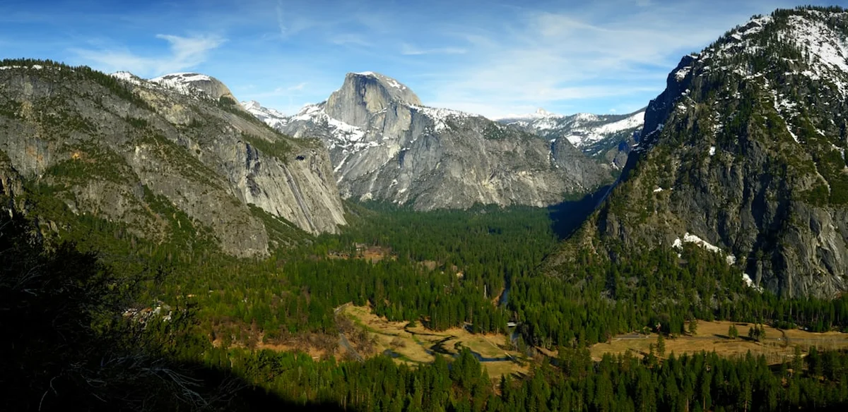
The Half Dome hike is the definitive mountain experience in Yosemite National Park, California—a gruelling 27.4 km round-trip odyssey that ascends 1,460 metres from the lush valley floor to the stark, wind-swept summit of the world's most famous granite monolith. Rising 2,695 metres above sea level, Half Dome is an icon of the Sierra Nevada, a geological marvel that appears to have been cleanly sliced in half by the colossal forces of ancient glaciers. This journey is not merely a walk; it is a test of physical endurance, mental fortitude, and respect for the raw power of nature. The route takes hikers through a dramatic transition of ecosystems, from the thundering spray of the Mist Trail's waterfalls to the silent, ancient forests of Little Yosemite Valley, culminating in the heart-pounding ascent of the "Cables"—a 120-metre vertical scramble up the dome's sheer eastern face. For many, standing on the expansive 5-hectare summit is a life-defining achievement, offering a 360-degree panorama of the High Sierra that defies description.
- Distance: 27.4 km (round trip via Mist Trail)
- Elevation Gain: 1,460 m
- Duration: 10–12 hours
- Difficulty: Very Challenging (requires high fitness and head for heights)
- Highest Point: 2,695 m (Summit of Half Dome)
- Permits: Mandatory for the sub-dome and cable section (lottery-based)
- Best Time: Late May to early October (when cables are up)
- Trailhead: Happy Isles (Shuttle Stop #16), Yosemite Valley
Overview
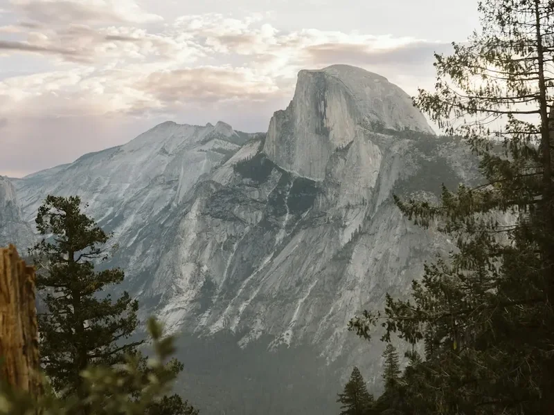
Half Dome is the crown jewel of Yosemite's hiking trails, a formidable granite giant that dominates the eastern end of Yosemite Valley. While the park offers hundreds of kilometres of trails, none carry the prestige or the peril of the Half Dome ascent. The hike is a masterclass in vertical progression. It begins at the Happy Isles trailhead, where the Merced River roars with the meltwater of the high country. The initial kilometres are a relentless climb up the Mist Trail, where hikers are often drenched by the spray of Vernal and Nevada Falls—a refreshing, if exhausting, introduction to the day's labour. As the trail levels out into the sandy flats of Little Yosemite Valley, the environment shifts to a serene pine forest, providing a brief psychological reprieve before the final, brutal push toward the sub-dome.
The character of the hike changes fundamentally once you reach the granite shoulder. The trees thin, the air cools, and the scale of the landscape becomes overwhelming. The sub-dome presents a series of steep, exposed granite switchbacks that test the lungs and the resolve. However, the true climax is the Cables. For the final 120 metres, hikers must pull themselves up a 45-degree incline using two steel cables bolted into the rock. It is a visceral, exposed experience that requires steady hands and a calm mind. The granite here has been polished smooth by millions of footsteps, making every placement of the foot a conscious decision. Once atop the dome, the world opens up. The valley floor lies nearly a vertical kilometre below, and the jagged peaks of the Cathedral Range stretch toward the horizon. It is a landscape of grey stone and blue sky, a place where the geological history of the Earth feels tangible and immediate.
This is a hike of extremes. In the height of summer, temperatures on the exposed granite can soar above 30 degrees Celsius, while sudden afternoon thunderstorms can turn the dome into a lightning rod of immense danger. Success on Half Dome requires meticulous planning, an early start (often before 5:00 AM), and a deep respect for the mountain's moods. It is a journey that demands everything from the hiker and, in return, provides a perspective on the natural world that few other places on the planet can match.
Wakahi Guide
Detailed route notes, maps, logistics & tips for the Half Dome Hike Yosemite (PDF).
History and Cultural Context
The history of Half Dome is a narrative of perceived impossibility transformed into an icon of human endeavour. To the indigenous Ahwahneechee people, the original inhabitants of Yosemite Valley, the dome was known as "Tis-sa-ack," named after a figure in a traditional legend involving a husband and wife whose quarrel transformed them into the valley's great stone monuments. The dark streaks of lichen that run down the face of the dome were said to be the tears of Tis-sa-ack, forever etched into the granite. For centuries, the Ahwahneechee lived in the shadow of the dome, recognising it as a sacred and inaccessible heights.
In the mid-19th century, as European-American explorers and surveyors entered the valley, Half Dome was declared "perfectly inaccessible" by Josiah Whitney of the California Geological Survey in 1865. He famously stated that it was "probably the only one of the prominent points about the Yosemite which never has been, and never will be, trodden by human foot." This challenge was answered only ten years later by George Anderson, a Scottish trail builder and former sea captain. In October 1875, Anderson reached the summit by drilling holes into the granite and inserting iron eye-bolts, using them as steps and handholds. He essentially "sewed" his way up the dome, proving that the "inaccessible" was merely a matter of determination and engineering.
The modern cable system was first installed by the Sierra Club in 1919 to allow non-climbers to experience the summit safely. Over the decades, these cables have been replaced and reinforced, but the fundamental experience remains remarkably similar to that of the early 20th-century adventurers. In 1984, Yosemite National Park was designated a UNESCO World Heritage site, and Half Dome stands as the central symbol of this protection. Today, the dome is not only a destination for hikers but a world-renowned arena for big-wall rock climbing, with the "Regular Northwest Face" route (first climbed in 1957) being a legendary milestone in the history of the sport. Walking the trail today is to follow in the footsteps of indigenous legends, Victorian explorers, and the pioneers of modern conservation.
Want more background? Read extended notes on history and cultural context → Learn more
Seasonal Highlights and Weather Reality
The Half Dome hiking season is strictly dictated by the presence of the cables. Typically, the National Park Service installs the cables (raising them onto their poles) on the Friday before Memorial Day (late May) and removes them (laying them flat against the rock) after the second Monday in October. Hiking the dome when the cables are "down" is an advanced mountaineering feat that requires specialised equipment and is not recommended for general hikers.
Spring (Late May to June): This is the most dramatic time to hike. The waterfalls—Vernal and Nevada—are at their peak flow, fuelled by the melting snowpack of the High Sierra. The Mist Trail lives up to its name, and hikers should expect to be completely soaked. However, snow can often linger on the sub-dome and the summit well into June, creating slippery conditions. Temperatures are generally mild, but the Merced River is dangerously high and cold.
Summer (July to August): This is the most popular time to hike, but it brings significant challenges. Heat is the primary concern; the granite sections of the trail act as a heat sink, and temperatures on the dome can be 10 degrees hotter than in the forest. Afternoon thunderstorms are a frequent and deadly occurrence. If clouds begin to build over the dome, hikers must descend immediately. Lightning strikes on Half Dome are common, and the exposed granite offers no protection.
Autumn (September to early October): Many experienced hikers consider this the best time. The crowds thin, the air is crisp and clear, and the risk of thunderstorms decreases. The waterfalls will be significantly reduced—sometimes to a mere trickle—but the stability of the weather and the cooler temperatures make the physical exertion more manageable. The days are shorter, however, making a pre-dawn start even more critical to ensure a return before darkness.
Winter (November to April): The trail to the base of the dome remains open, but the cables are down and the Mist Trail is often closed due to ice and rockfall hazards. This is a season for snowshoeing and winter mountaineering, requiring a completely different set of skills and gear.
Recommended Itinerary
Half Dome Day Hike Route Progression
Phase 1: The Ascent to Nevada Fall (The Mist Trail)
- Distance: 4.5 km
- Elevation gain: 600 m
- Time: 2–3 hours
- Start at Happy Isles (Stop #16) no later than 05:30 AM.
- Cross the bridge over the Merced River for your first view of the dome.
- Ascend the steep stone stairs of the Mist Trail alongside Vernal Fall (97 m).
- Continue climbing to the top of Nevada Fall (181 m), the last major water source.
- The "Mist" section is physically demanding and will likely soak your gear; ensure electronics are protected.
Phase 2: Little Yosemite Valley to the Sub-Dome
- Distance: 6.5 km
- Elevation gain: 450 m
- Time: 2.5–3.5 hours
- The trail levels out as you enter Little Yosemite Valley, a sandy, forested basin.
- Pass the backpackers' campground and follow the signs for Half Dome.
- The trail begins a long, steady series of switchbacks through a forest of Red Fir and Western White Pine.
- As you rise above the treeline, the granite becomes more prominent and the views of the backcountry open up.
- Arrive at the base of the sub-dome, where a ranger will check your permits.
Phase 3: The Sub-Dome and the Cables
- Distance: 1.5 km
- Elevation gain: 410 m
- Time: 1.5–2.5 hours
- Ascend the sub-dome via steep, exposed granite switchbacks. This is often cited as the most exhausting part of the hike.
- Reach the base of the cables. Don your gloves and wait for a gap in the traffic.
- Ascend the 120 metres of steel cables. Use the wooden slats (spaced every 3 metres) as resting points.
- Summit Half Dome (2,695 m). Spend time exploring the 5-hectare plateau and take in the views of Tenaya Canyon and the Valley floor.
- Exercise extreme caution near the edges, particularly "The Visor."
Phase 4: The Long Descent
- Distance: 14.9 km (via John Muir Trail for a gentler descent)
- Elevation loss: 1,460 m
- Time: 4–5 hours
- Descend the cables carefully, facing the rock if you feel unstable.
- Retrace your steps to the top of Nevada Fall.
- RECOMMENDED: Take the John Muir Trail (JMT) back to the valley. It is 2.5 km longer but much easier on the knees than the Mist Trail stairs.
- The JMT offers spectacular alternative views of Liberty Cap and the back of Half Dome.
- Finish back at Happy Isles and take the shuttle to your accommodation or vehicle.
Important Notes:
- Total moving time is typically 10–12 hours; plan for a 14-hour day including breaks.
- Turn-around time: If you have not reached the summit by 1:00 PM, you should turn back to ensure a safe descent before dark.
- Water: There is no water past Nevada Fall. You must carry at least 4 litres per person.
- The cables can become very crowded; patience and courtesy are essential for safety.
Planning and Bookings
Book Your Trip
Everything you need to plan your journey
Accommodation
Find places to stay near El Portal, California
Flights
Search flights to El Portal, California
Essential Preparation
The Half Dome hike is a significant physical undertaking that should not be underestimated. Preparation begins months in advance with a focused fitness regime. You should be comfortable walking 25+ kilometres with significant elevation gain. Cardiovascular endurance is key, but leg strength—specifically for the thousands of stone steps—is what will carry you through the final hours. Training on stairs or steep hills with a weighted pack is highly recommended.
Logistically, you must base yourself in or near Yosemite Valley. Accommodation inside the park (Yosemite Valley Lodge, Curry Village, or campgrounds) should be booked up to a year in advance. If staying outside the park in El Portal or Mariposa, factor in the 30–60 minute drive and the potential for traffic delays at the park entrance. Ensure your vehicle has a Yosemite entry reservation if required during peak season.
Trail Accommodation
This is primarily a day hike, and most participants complete it in a single push from the valley floor. However, for those wishing to break the journey, there is one specific option.
Little Yosemite Valley (LYV) Campground:
- Located approximately 7.5 km from the trailhead.
- Requires a Wilderness Permit (separate from the day-hike permit).
- Facilities: Shared food lockers (bear-proof), composting toilets, and designated tent sites.
- Water: Must be filtered from the nearby Merced River.
- Benefits: Allows you to summit Half Dome early in the morning before the day-hiking crowds arrive from the valley.
- Cost: Small administrative fee for the wilderness permit, but demand is extremely high.
Valley Accommodation: If not camping, Curry Village offers "Tent Cabins" which are the closest traditional accommodation to the trailhead. Staying here allows you to walk to the trailhead at 4:30 AM without needing to move your car or rely on the shuttle (which starts at 7:00 AM).
Required Gear
- Hiking Boots: Sturdy, broken-in boots with excellent grip (Vibram soles or similar). The granite is polished and can be slippery.
- Gloves: Essential for the cables. Durable work gloves with rubberised palms provide the necessary grip and protect your hands from friction burns and steel splinters.
- Headlamp: With fresh batteries. You will almost certainly start in the dark and may finish in the dark.
- Waterproof Jacket: Even in summer, the Mist Trail will soak you, and weather on the summit can turn cold and wet instantly.
- Sun Protection: High-SPF sunscreen, a wide-brimmed hat, and UV-rated sunglasses. The exposure on the granite is intense.
- First Aid Kit: Include blister pads (moleskin), ibuprofen, and electrolyte salts.
- Day Pack: 20–30L capacity with a high-quality hip belt to take the weight off your shoulders.
What to Bring
- Water: Minimum 4 litres per person. A hydration bladder is recommended for easy sipping during the climb.
- Water Filter: A lightweight filter (like a Sawyer Squeeze) allows you to refill at the Merced River (Nevada Fall) to save weight on the initial climb.
- High-Calorie Food: You will burn 4,000–6,000 calories. Bring a mix of complex carbs and simple sugars: nuts, jerky, energy bars, and dried fruit.
- Electrolytes: Powder or tablets to add to your water to prevent cramping and hyponatremia.
- Trash Bags: To pack out all waste, including fruit peels and nut shells.
- Permit Printout: A hard copy or a downloaded digital version of your permit and photo ID (rangers check these at the base of the sub-dome).
Permits
Permits are mandatory to hike beyond the base of the sub-dome to the summit of Half Dome when the cables are up. This system was implemented to manage extreme overcrowding and improve safety on the cables. The National Park Service limits the number of hikers to approximately 300 per day (225 day hikers and 75 backpackers).
The Pre-Season Lottery:
- Applications are accepted throughout the month of March via Recreation.gov.
- You can apply for up to seven specific dates or a range of dates.
- Results are typically announced in mid-April.
- Success rates vary wildly; weekends are extremely difficult to secure, while mid-week dates offer better odds.
The Daily Lottery:
- If you miss the pre-season lottery, a limited number of permits are released daily.
- You must apply two days before your intended hike (e.g., apply on Thursday for a Saturday hike).
- The application window is from 12:01 AM to 4:00 PM Pacific Time.
- This allows for flexibility if you are already in the park and the weather forecast looks favourable.
Costs and Regulations:
- Application Fee: US$10 (non-refundable, covers up to 6 people).
- Permit Fee: US$10 per person (only paid if you win).
- Permits are non-transferable. The "trip leader" named on the permit must be present with photo ID.
- Rangers are stationed at the base of the sub-dome and are strict; attempting the hike without a permit can result in significant fines.
Other Activities in the Area
Yosemite National Park is a vast wilderness with endless opportunities for exploration. If you have extra days in the valley, consider these activities:
- Glacier Point: For those who want the view without the 12-hour hike, Glacier Point offers a stunning perspective of Half Dome and the High Sierra, accessible by car or shuttle bus.
- The Valley Floor Loop: A gentle 20 km flat trail that meanders through meadows and forests, offering iconic views of El Capitan, Sentinel Rock, and Yosemite Falls.
- Mirror Lake: A short, easy walk from the shuttle stop that takes you directly beneath the sheer face of Half Dome. In spring, the lake reflects the dome perfectly.
- Ansel Adams Gallery: Located in Yosemite Village, this gallery showcases the legendary photography of Ansel Adams and offers workshops for aspiring photographers.
- Rafting the Merced River: In early summer, you can rent rafts and float down the Merced River, providing a unique and relaxing perspective of the valley's granite walls.
- Tuolumne Meadows: A 90-minute drive from the valley, this high-elevation meadow offers a completely different alpine environment with crystal-clear lakes and jagged peaks.
Safety and Conditions
The Threat of Lightning: This is the single greatest objective hazard on Half Dome. The dome is a massive, isolated conductor. If there is any sign of thunder or dark clouds building, do not attempt the sub-dome or the cables. If you are on the summit and weather approaches, descend immediately. Do not wait for the first drop of rain. If your hair stands on end or you hear a "crackling" sound from the cables, you are in immediate danger of a strike.
Cable Safety: The cables are physically demanding. Always keep at least one hand on a cable. If you feel overwhelmed, clip into the cables using a climbing harness and via ferrata lanyards—though this is not required, it provides significant peace of mind for those nervous about heights. Be aware of "down-traffic"; people descending are often tired and may be moving erratically. Communication and patience are vital.
Dehydration and Exhaustion: Many rescues on Half Dome are due to simple exhaustion or heat illness. The final climb is at high altitude (over 2,500 m), where the air is thinner. Pace yourself, drink before you are thirsty, and eat small amounts frequently. Know the signs of altitude sickness: headache, nausea, and dizziness. If symptoms persist, the only cure is to descend.
The "Death Slab" and Edges: The summit plateau is large, but the edges are deceptive. The granite can be crumbly, and the "Visor"—a famous overhanging ledge—is particularly dangerous. Stay well back from the edge, especially if it is windy. A slip here is fatal.
Water Safety: Never attempt to swim in the Merced River above the waterfalls. The current is deceptively strong, and the granite is slick. Every year, hikers are swept over the falls by entering the water in seemingly "calm" pools.
Side Trips and Points of Interest
The Mist Trail vs. John Muir Trail: While the Mist Trail is the most direct route, the John Muir Trail (JMT) is a spectacular alternative. Most hikers go up the Mist Trail and down the JMT. The JMT offers a stunning view of the "back" of Half Dome and the sheer face of Liberty Cap. It also provides a much gentler gradient, which is a blessing for tired knees on the 1,460-metre descent.
Vernal Fall Footbridge: Located just 1.3 km from the start, this is the first major landmark. It offers a classic view of the 97-metre Vernal Fall and is the last place to find a flushing toilet and a treated water fountain before the high country.
The Diving Board: For experienced navigators, a difficult off-trail scramble leads to "The Diving Board," a rock outcrop that provides the perspective Ansel Adams used for his most famous photograph of Half Dome, "Monolith, The Face of Half Dome." This is not for the casual hiker and requires excellent route-finding skills.
Clouds Rest: While not a side trip you can do on the same day, Clouds Rest is the peak directly behind Half Dome. It is actually higher (3,025 m) and offers a view *down* onto the summit of Half Dome. It is a 23 km round trip from Tenaya Lake and does not require a permit, making it an excellent alternative if you fail to secure a Half Dome permit.
Leave No Trace
Yosemite is one of the most visited national parks in the world, and the Half Dome trail sees immense pressure. Adhering to Leave No Trace principles is not just a suggestion; it is essential for the survival of this wilderness.
Key Principles for Half Dome:
- Pack it in, Pack it out: This includes everything. Orange peels, nut shells, and tissues take years to decompose in the thin alpine soil. Carry a small zip-lock bag for your micro-trash.
- Stay on the Trail: The switchbacks on the sub-dome are prone to erosion. Cutting corners destroys the stone-work and kills the fragile alpine plants that hold the soil in place.
- Respect Wildlife: Do not feed the marmots or squirrels on the summit. They have become aggressive due to human feeding and can bite. Store your food securely in your pack; marmots are known to chew through expensive gear to get to a granola bar.
- Proper Waste Disposal: Use the composting toilets at Nevada Fall and Little Yosemite Valley. If you must go elsewhere, dig a "cathole" 15–20 cm deep at least 60 metres from water sources. Pack out all toilet paper.
- Leave What You Find: Do not take rocks or plants as souvenirs. The beauty of the dome belongs to everyone.