Hakarimata Summit Track
The Hakarimata Summit Track is a rewarding day walk located in the Waikato region of New Zealand's North Island. This relatively short but steep trail offers a challenging climb to the summit of the Hakarimata Range, providing panoramic views over the surrounding landscape, including the Waikato River, Ngaruawahia, and the distant Kaimai and Pirongia ranges. Known for its dense native forest, historical significance, and the iconic Hakarimata Rail Trail, this track is a popular destination for locals and visitors seeking a vigorous outdoor experience close to urban centres.
- Distance: 8.0 km return
- Duration: 3–4 hours
- Season: Year-round (best in dry weather)
- Elevation gain: 623 m
- Difficulty: Moderate to Hard (due to steepness)
- Trailhead Access: Main access via Hakarimata Road car park near Ngaruawahia. Well-signposted from State Highway 1. Alternative access from Brownlee Avenue, Huntly.
- Closest City: Ngaruawahia
Overview
The Hakarimata Summit Track is a testament to the power of elevation gain over a short distance. While the total length of the loop is only 8.0 kilometres, the ascent of 623 metres means that much of the walk is a sustained, steep climb. This challenging gradient ensures that even experienced walkers will feel the burn in their legs and lungs, making it a fantastic workout. The trail winds through beautiful native bush, offering a welcome respite from the open farmland and urban areas below. The air is fresh, and the sounds of the forest provide a natural soundtrack to your ascent.
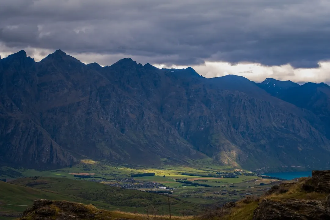
The track is well-maintained, with a combination of formed paths, wooden steps, and boardwalks in wetter sections. As you climb, the vegetation changes, with larger trees giving way to more sub-alpine flora closer to the summit. The views that unfold as you gain altitude are a significant reward for the effort. From the summit, on a clear day, you can see for miles. The Waikato River snakes its way through the landscape, Ngaruawahia town is spread out below, and on a good day, the Kaimai Range to the east and Mount Pirongia to the west are visible. The summit itself is marked by a trig station, a perfect spot for photos and to soak in the expansive vistas.
A notable feature of the Hakarimata Range is the Hakarimata Rail Trail, a section of the old railway line that once ran through the area. While not part of the main summit track, it offers a flatter, more accessible walking option and a glimpse into the region's industrial past. The combination of challenging terrain, native bush, historical elements, and stunning views makes the Hakarimata Summit Track a highly recommended day walk for those looking for a substantial challenge and rewarding scenery.
History and Cultural Context
The Hakarimata Range holds significant cultural and historical importance for the local iwi, particularly Waikato-Tainui. The name "Hakarimata" itself is derived from Māori language, with various interpretations suggesting connections to the land and its features. For centuries, Māori have used these lands for sustenance, shelter, and as strategic vantage points. The range's prominent position overlooking the Waikato River made it a significant area for observation and defence.
In more recent history, the Hakarimata Range played a role in the development of the region. The construction of the Hakarimata Rail Trail, which forms part of the walking network, dates back to the early 20th century. This railway line was crucial for transporting goods and materials, connecting communities and facilitating the growth of industries in the Waikato. The remnants of this railway, including cuttings and embankments, are still visible and offer a tangible link to the area's past.
The Hakarimata Summit Track itself, while not a historic Māori trail in the same vein as some of New Zealand's Great Walks, represents a modern effort to provide public access to the natural beauty and panoramic views of the range. The development and maintenance of the track by local authorities and volunteer groups ensure that this significant landscape remains accessible for recreation and appreciation, preserving its natural and historical heritage for future generations.
Seasonal Highlights and Weather Reality
The Hakarimata Summit Track is accessible and enjoyable year-round, but the experience can vary significantly with the seasons.
Spring (September–November): This is a beautiful time to visit. The native bush comes alive with new growth, and the forest floor may be dotted with early wildflowers. The weather is generally mild, though occasional rain showers are common. Sandflies can start to become noticeable as temperatures rise.
Summer (December–February): Summer offers the warmest temperatures, making it ideal for a challenging climb. However, it can also be the busiest season, and the track can be exposed in sections, so sun protection is essential. Higher temperatures can increase the prevalence of sandflies, especially in shaded or damp areas. Afternoon thunderstorms are also a possibility, so it's wise to start your walk early.
Autumn (March–May): Autumn is often considered one of the best times to walk the Hakarimata Summit Track. The weather is typically stable and cooler, making the steep climb more comfortable. The foliage may begin to change colour, adding a different kind of beauty to the forest. Sandfly activity usually decreases significantly.
Winter (June–August): Winter can bring cooler temperatures and increased rainfall. The track can become muddy and slippery, especially on the steeper sections and wooden steps. However, on clear winter days, the views from the summit can be spectacular, with crisp air and often dramatic cloud formations. Frost is possible at higher elevations, and while snow is rare at the summit, it can occur during particularly cold snaps. Waterproof gear is essential during winter months.
Weather Considerations: Regardless of the season, the weather in the Hakarimata Range can change rapidly. It is crucial to check the local weather forecast before you go and be prepared for all conditions, including rain, wind, and cooler temperatures, especially at the summit. The steepness of the track means that even on a warm day, you can generate significant body heat, but the summit can be exposed and cooler.
Recommended Itinerary

Hakarimata Summit Track - Day Walk Itinerary
Early Morning (Approx. 8:00 AM - 9:00 AM): Arrival and Preparation
- Arrive at the Hakarimata Road car park.
- Ensure you have checked the weather forecast and are prepared for the conditions.
- Use the toilet facilities if available.
- Apply sunscreen and insect repellent.
- Fill water bottles.
- Briefly review the track map or signage.
Morning (Approx. 9:00 AM - 11:00 AM): Ascent to the Summit
- Begin the Hakarimata Summit Track from the main trailhead.
- The initial section of the track is a steady climb through native bush.
- You will encounter numerous wooden steps and sections of formed track.
- The gradient becomes increasingly steep as you ascend.
- Take short breaks as needed to catch your breath and hydrate.
- Enjoy the sounds and sights of the forest.
- Look out for the historical markers related to the old railway line if you take the alternative route or explore side paths.
Midday (Approx. 11:00 AM - 12:00 PM): Summit Experience
- Reach the summit of the Hakarimata Range.
- Admire the 360-degree panoramic views.
- Locate the trig station for photo opportunities.
- Identify landmarks such as the Waikato River, Ngaruawahia, and distant mountain ranges.
- Enjoy a well-deserved snack or packed lunch.
- Spend time appreciating the expansive scenery and the accomplishment of the climb.
Afternoon (Approx. 12:00 PM - 2:00 PM): Descent and Return
- Begin the descent back down the Hakarimata Summit Track.
- The descent can be as challenging as the ascent, requiring careful footing on the steep sections and steps.
- Take your time to avoid slips and falls.
- Continue through the native bush, enjoying the different perspective on the way down.
- If time and energy permit, consider a brief exploration of the Hakarimata Rail Trail for a flatter, historical walk.
- Return to the Hakarimata Road car park.
- Ensure you have collected all your belongings and left the area tidy.
Alternative Access (Brownlee Avenue, Huntly):
- This access point also leads to the Hakarimata Summit Track, often via a slightly different initial route or connecting paths.
- The climb remains steep and challenging regardless of the starting point.
- Ensure you are familiar with the specific trail network from this access if choosing it.
Planning and Bookings
Book Your Trip
Everything you need to plan your journey
Accommodation
Find places to stay near Ngaruawahia
Flights
Search flights to Ngaruawahia
Essential Preparation
The Hakarimata Summit Track is a day walk, meaning no overnight accommodation is required. However, thorough preparation is still essential due to the track's challenging nature and the potential for rapidly changing weather conditions. The closest town for amenities and accommodation is Ngaruawahia, which is a short drive from the main trailhead. Larger centres like Hamilton are also within easy reach, offering a wider range of services.
Fitness: The track is rated as moderate to hard due to its steepness. A good level of cardiovascular fitness and leg strength is recommended. If you are not accustomed to steep climbs, consider building up your fitness beforehand. The 623 metres of elevation gain over a relatively short distance means sustained effort is required.
Logistics: The main access is via Hakarimata Road, which is well-signposted from State Highway 1. There is a car park at the base of the track. An alternative access point is from Brownlee Avenue in Huntly. Ensure your vehicle is suitable for potentially unsealed or gravel access roads, although the main car park is generally well-maintained.
Base Town/City Information:
- Ngaruawahia: The closest town, offering basic amenities, including a supermarket, petrol station, and local eateries. It's a convenient place to stop for supplies or a meal before or after your walk.
- Hamilton: Approximately a 20-30 minute drive from the trailhead, Hamilton is the largest city in the Waikato region. It provides a full range of services, including extensive accommodation options (hotels, motels, backpackers), supermarkets, outdoor gear shops, restaurants, and cafes.
Trail Accommodation
This is a day hike requiring no overnight accommodation.
Required Gear
- Sturdy walking boots: Waterproof and with good ankle support are highly recommended due to the steep, uneven terrain and potential for mud.
- Backpack: A comfortable day pack (20-30 litres) to carry essentials.
- Waterproof jacket: Essential for protection against rain and wind, which can change quickly.
- Warm layers: Even on a warm day, the summit can be cooler and exposed. A fleece or thermal top is advisable.
- Sun protection: Hat, sunglasses, and sunscreen are important, especially during summer months, as sections of the track are exposed.
- Navigation: While the track is generally well-marked, a map or GPS device is always a good idea, especially if exploring less-used sections or the rail trail.
- First-aid kit: A basic kit with plasters, antiseptic wipes, pain relievers, and any personal medications.
- Head torch: Useful if you plan to start very early or finish late, or in case of unexpected delays.
What to Bring
- Food: Plenty of high-energy snacks and a packed lunch. There are no facilities on the track.
- Water: Carry at least 1.5–2 litres of water per person. There are no water sources on the track that are safe to drink without treatment.
- Water treatment: If you plan to use stream water (not recommended for this track), carry a filter or purification tablets.
- Insect repellent: Sandflies can be present, particularly in warmer months and damp conditions.
- Toilet paper and hand sanitiser: For use if needed, as toilet facilities are limited to the car park area.
- Mobile phone: For emergencies, though reception can be patchy in the range.
- Camera: To capture the stunning views from the summit.
- Walking poles: Highly recommended for the steep ascent and descent to reduce strain on knees and improve stability.
Permits
No permits are required to walk the Hakarimata Summit Track. It is a public access area managed by the local council or Department of Conservation, and no entry fees or booking systems are in place for day walkers.
However, it is always advisable to check for any temporary track closures or alerts before your visit. These can be due to maintenance, weather events, or other safety concerns. Information is usually available through the local council's website or by contacting their parks and recreation department.
Important Considerations:
- Group Size: While there are no restrictions on group size for day walks, be mindful of the track's capacity, especially on popular days.
- Commercial Operations: If you are planning a guided walk or a commercial activity on the track, you may need to obtain specific permits or permissions from the managing authority.
- Private Property: Ensure you stay within the designated public access areas and respect any private property boundaries in the vicinity of the trailheads.
Other Activities in the Area
The Hakarimata Range and its surroundings offer several other activities for visitors:
- Hakarimata Rail Trail: A flatter, more accessible walking and cycling option that follows the historic railway line. It's a great alternative for those seeking a less strenuous experience or interested in the area's industrial heritage.
- Waikato River Trails: Explore sections of the extensive Waikato River Trails network, which offers opportunities for walking, cycling, and enjoying the riverine landscapes.
- Ngaruawahia Town Exploration: Visit the town of Ngaruawahia, the historic seat of the Māori King. Explore local shops, cafes, and learn about the region's rich cultural history.
- Hamilton Gardens: A world-renowned botanical garden located in Hamilton, featuring a variety of themed gardens that showcase different civilisations and historical periods. It's a beautiful place for a leisurely stroll.
- Lake Waikare: A large shallow lake south of Huntly, offering opportunities for fishing, birdwatching, and enjoying the open water scenery.
- Mount Pirongia: For those seeking a more challenging multi-day hike or a longer day walk, Mount Pirongia offers a different volcanic landscape with extensive native forest and summit views.
Safety and Conditions
Pre-Departure Checks:
- Weather Forecast: Always check the MetService forecast for the Waikato region and specifically for Ngaruawahia or the Hakarimata Range before you depart. Be prepared for rapid changes, especially at the summit.
- Track Conditions: While generally well-maintained, the track can become muddy and slippery after rain, particularly on the steep sections and wooden steps. Check local council websites or social media for any reported issues or closures.
- Emergency Contacts: Ensure your mobile phone is fully charged. Save the New Zealand emergency number (111) and consider informing someone of your plans, including your expected return time.
Track Hazards:
- Steepness: The primary hazard is the steep gradient. Take your time, use handrails and steps where provided, and maintain good footing. Descending can be as challenging as ascending.
- Slippery Surfaces: Mud, wet leaves, and damp wooden steps can be very slippery. Wear appropriate footwear with good grip.
- Exposed Summit: The summit area is exposed to wind and can be significantly cooler than the bush line. Hypothermia is a risk, even on mild days, if you become wet and stop for an extended period.
- Sandflies: These biting insects can be prevalent, especially during warmer months and in damp, shaded areas. Use effective repellent.
- Insects and Wildlife: While generally not dangerous, be aware of common New Zealand insects and native birds.
General Safety Advice:
- Stay on the Track: Do not stray from marked paths to avoid getting lost and to protect the fragile native bush.
- Carry Sufficient Water: Dehydration can occur quickly, especially during a strenuous climb.
- Inform Someone: Let a friend or family member know where you are going and when you expect to be back.
- First Aid: Be prepared to administer basic first aid for minor injuries.
- Respect the Environment: Follow Leave No Trace principles.
Side Trips and Points of Interest
Hakarimata Summit Trig: The highest point of the track, marked by a trig station. This is the prime location for panoramic views. Take time to circumnavigate the summit area to appreciate the 360-degree vistas. On a clear day, you can see the Kaimai Range to the east, Mount Pirongia to the west, the Waikato River, and the towns of Ngaruawahia and Huntly.
Hakarimata Rail Trail: While not directly on the summit track, the historic Hakarimata Rail Trail is a significant point of interest in the range. This relatively flat track follows the path of the old railway line and offers a different perspective on the area's history and landscape. It can be accessed from various points, including near the main Hakarimata Road trailhead, and provides a gentler walking experience.
Native Bush and Flora: The track passes through beautiful native bush, including mature trees like tawa, rewarewa, and mahoe. Keep an eye out for the diverse undergrowth of ferns, mosses, and smaller shrubs. The changing vegetation as you ascend provides a natural indicator of elevation and microclimate.
Waikato River Views: As you climb, intermittent views of the Waikato River become visible. These become more expansive as you gain altitude, offering a sense of the river's importance to the region's geography and history.
Historical Remnants: Along the broader Hakarimata Range network, you may find remnants of past human activity, including old cuttings and embankments from the railway line. These serve as reminders of the area's development and the efforts to traverse this challenging terrain.
Leave No Trace
The Hakarimata Summit Track, like all natural areas, benefits greatly from visitors adhering to Leave No Trace principles. These guidelines help preserve the natural beauty and ecological integrity of the Hakarimata Range for everyone to enjoy.
Your responsibility as a walker:
- Pack it in, Pack it out: Carry out all rubbish, including food scraps, wrappers, and any other waste you generate. Do not bury or burn rubbish.
- Stay on the Track: Stick to the marked trail to prevent erosion and protect fragile vegetation. Straying can damage sensitive plant life and create new, undesirable paths.
- Respect Wildlife: Observe native birds and insects from a distance. Do not feed them, as this can disrupt their natural behaviour and diet.
- Dispose of Waste Properly: Use toilet facilities at the trailhead if available. If nature calls on the track, dig a cathole at least 70 metres away from water sources, trails, and campsites, and bury human waste. Pack out toilet paper.
- Leave what you find: Do not remove plants, rocks, or any other natural objects from the area. Take only photographs and memories.
- Minimise Campfire Impacts: Campfires are not permitted on this day walk. If you were camping elsewhere, use established fire rings and ensure fires are completely extinguished.
- Be Considerate of Other Visitors: Keep noise levels down, yield to uphill walkers, and be respectful of others' enjoyment of the natural environment.
By following these principles, you help ensure that the Hakarimata Summit Track remains a pristine and enjoyable destination for generations to come.