Hadrian's Wall Path - A Journey Across the Roman Frontier
The Hadrian's Wall Path is a world-class National Trail that stretches 135 kilometres across the narrow neck of Northern England, following the remains of the Roman Empire's most formidable northern frontier. This coast-to-coast journey begins at the urban shipyards of Wallsend in Newcastle upon Tyne on the east coast and concludes at the tranquil salt marshes of Bowness-on-Solway on the west. Along the way, walkers traverse a landscape of immense historical significance and startling natural beauty, crossing the rugged basalt crags of the Whin Sill, passing through the vibrant city of Carlisle, and exploring the rolling pastoral farmland of Northumberland and Cumbria. This is not merely a hike; it is a walk through two millennia of history, where the stones beneath your feet tell the story of emperors, legionaries, and the shifting borders of a vanished empire.
- Distance: 135.0 km one-way
- Duration: 6–9 days
- Season: May to October (the "Passport" season; winter walking is discouraged to protect the archaeology)
- Accommodation: B&Bs, campsites, bunkhouses, and historic inns
- Highest point: Winshield Crags (345 m)
- Total Elevation Gain: Approximately 3,500 m
- Direction: Traditionally walked East to West (following the wall's construction) or West to East (with the prevailing wind)
Overview
Hadrian's Wall Path is unique among the UK's National Trails for its blend of archaeological heritage and diverse topography. Designated as a National Trail in 2003, it follows the UNESCO World Heritage Site of Hadrian's Wall, which was constructed on the orders of Emperor Hadrian starting in AD 122. The trail is remarkably varied: the eastern section is largely urban and industrial, following the River Tyne through Newcastle; the central section is wild, dramatic, and physically demanding as it scales the volcanic ridges of the Whin Sill; and the western section is gentle and pastoral, following the Solway Firth into the quiet borderlands of Cumbria.
The experience of walking the wall is defined by the "rhythm of the Roman mile." Every Roman mile (approximately 1,480 metres), the Romans built a milecastle—a small fortlet—and between each milecastle were two turrets. Even where the stone wall has been robbed for local building material over the centuries, the massive earthworks known as the Vallum (a deep ditch and mound system) remain visible, carving a permanent scar across the English countryside. Walkers will find themselves constantly transitioning between the modern world and the ancient one, passing through working farms where Roman stones are integrated into 18th-century barns, and standing on ridges where the view north into "Barbaricum" remains as vast and untamed as it appeared to a Roman sentry 1,900 years ago.
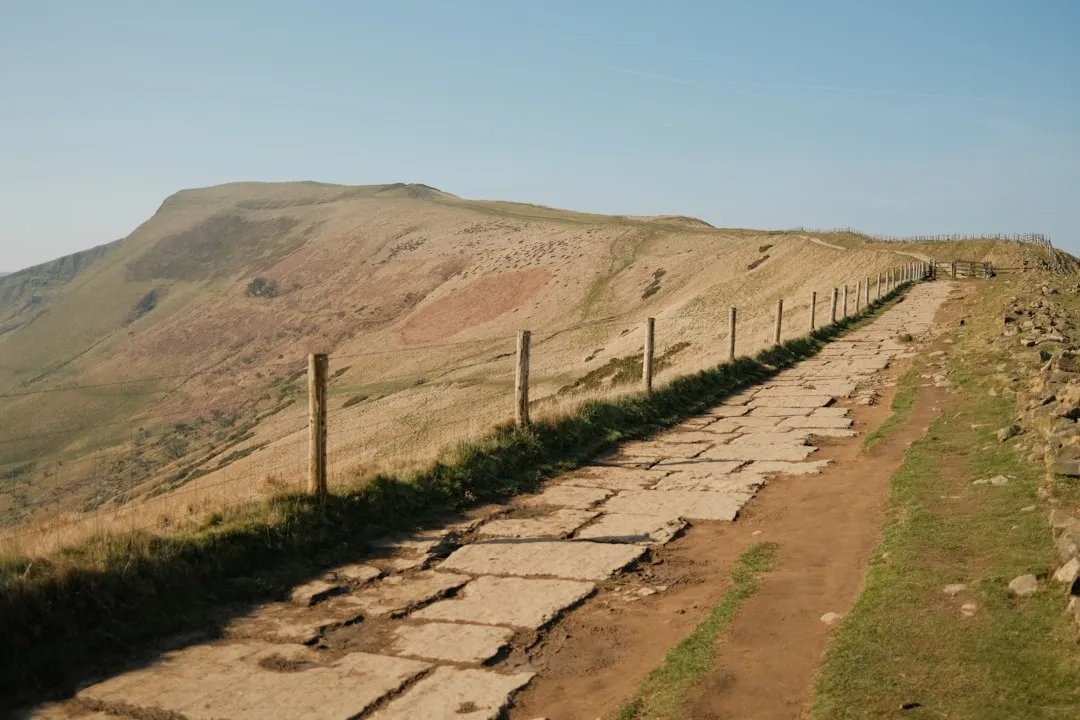
While the maximum elevation of 345 metres may seem modest compared to alpine routes, the central section's "rollercoaster" terrain—frequent, steep ascents and descents over the crags—provides a significant physical challenge. The path is well-signed with the National Trail acorn symbol, but the weather in Northern England is notoriously fickle. Rain, mist, and wind can transform the experience in minutes, particularly on the exposed high ground of Northumberland. Despite its popularity, the trail offers profound moments of solitude, especially in the early morning or late evening when the shadows of the wall stretch across the moorland, evoking the deep history of this ancient boundary.
History and Cultural Context
Hadrian's Wall was the north-west frontier of the Roman Empire for nearly 300 years. Built by three legions—the II Augusta, VI Victrix, and XX Valeria Victrix—it was a monumental feat of engineering that required the movement of millions of tonnes of stone and earth. The wall was not just a defensive barrier; it was a sophisticated system of customs control, a symbol of imperial power, and a bustling corridor of trade and cultural exchange. At its peak, the wall was garrisoned by thousands of auxiliary soldiers from across the empire, including cavalry from Spain, archers from Syria, and infantry from Batavia (modern-day Netherlands).
The wall's history is one of constant evolution. Originally planned as a turf and stone rampart, it was later upgraded to a full stone wall in the east. After Hadrian's death, the frontier was briefly moved north to the Antonine Wall in Scotland, before being abandoned in favour of Hadrian's line once more. Following the collapse of Roman administration in Britain around AD 410, the wall fell into disrepair. For centuries, it served as a "quarry" for local inhabitants; many of the churches, castles, and farmhouses seen along the trail today were built using Roman stone. It wasn't until the 19th century, through the efforts of antiquarians like John Clayton, that the systematic preservation of the wall began.
Today, the wall is part of the "Frontiers of the Roman Empire" UNESCO World Heritage Site. The cultural context of the trail is deeply intertwined with the "Border Reivers" history of the 14th to 17th centuries—a period of lawlessness and clan warfare between England and Scotland. The "bastle houses" (fortified farmhouses) found along the route are a testament to this turbulent era. Walking the path today is an exercise in layering history, where Roman ruins, medieval churches, and industrial heritage coexist in a single, continuous landscape.
Want more background? Read extended notes on history and cultural context → Learn more
Seasonal Highlights and Weather Reality
The official walking season for Hadrian's Wall Path runs from May to October. This coincides with the "Passport" season, when the trail's stamping stations are active and the ground is generally dry enough to support the high volume of walkers without causing significant erosion to the sensitive archaeological layers beneath the turf.
Spring (May to June): This is arguably the best time to walk. The weather is often at its most stable, the wildflowers are in bloom, and the ground is firm. The "whin" (gorse) on the crags provides a vibrant yellow backdrop to the grey Roman stone. Daylight hours are long, allowing for a relaxed pace.
Summer (July to August): The warmest months, but also the busiest. Accommodation should be booked well in advance. While temperatures are rarely extreme (usually 18–24°C), the humidity can make the steep climbs in the central section feel more taxing. This is also the peak season for the "AD122" bus service, which makes logistics much easier.
Autumn (September to October): A beautiful time to witness the changing colours of the Northumberland National Park. The air is crisper, and the light is excellent for photography. However, the days shorten rapidly, and the risk of Atlantic storms bringing heavy rain increases.
Winter (November to April): Walking the full trail in winter is strongly discouraged by the National Trail authorities. The path becomes extremely muddy, and the "smearing" of mud over the archaeological remains causes permanent damage. Many museums, cafes, and B&Bs along the central section close during this period. If you do walk in winter, expect short daylight hours, freezing temperatures, and potentially hazardous ice on the steep crag sections.
Recommended Itinerary

8-Day Hadrian's Wall Path Itinerary (East to West)
Day 1: Wallsend to Heddon-on-the-Wall
- Distance: 24 km
- Elevation gain: 150 m
- Time: 6–7 hours
- Start at Segedunum Roman Fort in Wallsend
- Follow the River Tyne through the heart of Newcastle, passing under the iconic bridges
- Transition from urban industrial landscapes to the green outskirts of the city
- First significant remains of the wall visible at Denton Burn
- Arrive at Heddon-on-the-Wall, home to a substantial 100-metre stretch of broad wall
Day 2: Heddon-on-the-Wall to Chollerford
- Distance: 25 km
- Elevation gain: 250 m
- Time: 6–7 hours
- Follow the long, straight Roman road (the B6318 Military Road)
- The Vallum (earthworks) becomes clearly visible on the left
- Pass the site of Onnum (Haltonchesters) fort
- Descend into the North Tyne valley to the village of Chollerford
- Visit Chesters Roman Fort (Cilurnum) with its remarkably preserved bathhouse by the river
Day 3: Chollerford to Once Brewed (Steel Rigg)
- Distance: 19 km
- Elevation gain: 600 m
- Time: 5–6 hours
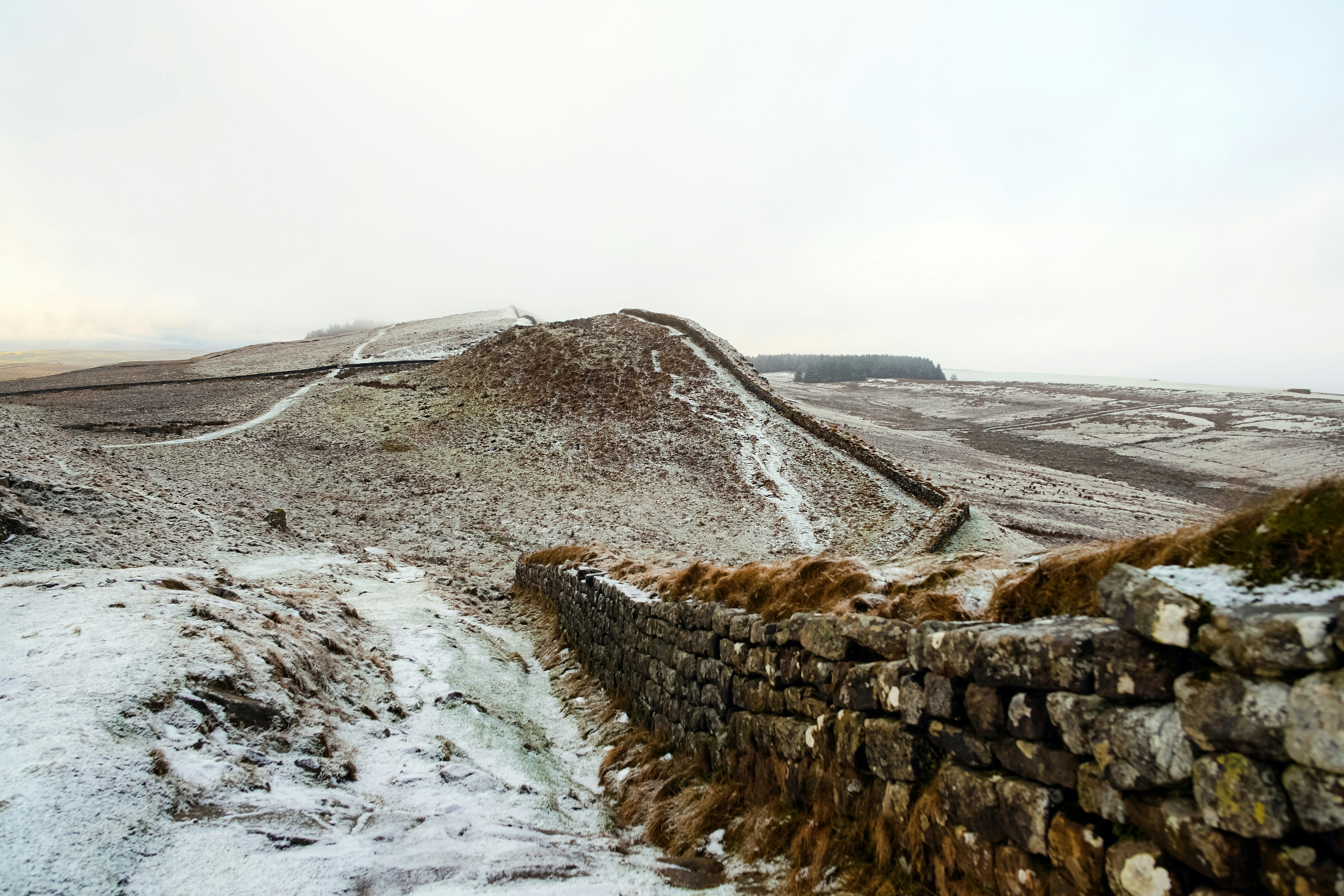
- The start of the "Crags" section—the most dramatic part of the trail
- Climb onto the Whin Sill, a volcanic ridge with sheer north-facing cliffs
- Pass Housesteads Roman Fort (Vercovicium), the most complete fort in Britain
- Walk the iconic "rollercoaster" ridges of Peel Crags and Highshield Crags
- Pass the site of the Sycamore Gap tree (now a stump, but still a poignant landmark)
- Arrive at Once Brewed, the central hub of the trail
Day 4: Once Brewed to Gilsland
- Distance: 14 km
- Elevation gain: 400 m
- Time: 4–5 hours
- Continue along the spectacular crags, reaching the trail's highest point at Winshield Crags (345 m)
- Spectacular views north into the Scottish borders and south to the North Pennines
- Pass the remains of Milecastle 42 (Cawfields) and the dramatic Great Chesters Fort
- Descend from the crags towards the village of Gilsland, crossing the border from Northumberland into Cumbria
- See the impressive remains of the Roman bridge abutment at Willowford
Day 5: Gilsland to Walton
- Distance: 13 km
- Elevation gain: 200 m
- Time: 4 hours
- Visit Birdoswald Roman Fort (Banna), situated on a high promontory overlooking the River Irthing
- The wall here transitions from stone to turf (the original construction material in the west)
- Follow the trail through rolling Cumbrian farmland
- Pass the site of Lanercost Priory (a short detour), built almost entirely from Roman stone
- Arrive in the quiet village of Walton
Day 6: Walton to Carlisle
- Distance: 18 km
- Elevation gain: 100 m
- Time: 5 hours
- A gentler day through fields and along quiet country lanes
- The wall is less visible here, but the Vallum continues to mark the route
- Follow the River Eden into the historic city of Carlisle
- Explore Carlisle Castle and the Tullie House Museum, which houses an extensive Roman collection
- Carlisle serves as a major logistical hub with plenty of services
Day 7: Carlisle to Bowness-on-Solway
- Distance: 24 km
- Elevation gain: 50 m
- Time: 6–7 hours
- Follow the River Eden out of the city towards the Solway Firth
- The landscape becomes flat and expansive, dominated by the tidal marshes
- Pass through the villages of Burgh-by-Sands and Drumburgh
- The final stretch follows the path of the wall along the coast with views across to Scotland
- Finish at the "Banks Promenade" in Bowness-on-Solway, the official end of the trail
Important Notes:
- The central section (Days 3 and 4) is significantly more strenuous than the rest of the trail
- The AD122 bus service runs seasonally and is excellent for skipping sections or returning to a base
- Always check the tide times if you plan to walk near the Solway marshes, though the path itself is generally safe
- The trail is well-marked, but a map (OS Explorer 315, 316, OL43) is essential for navigation in poor visibility
Planning and Bookings
Book Your Trip
Everything you need to plan your journey
Accommodation
Find places to stay near Newcastle upon Tyne
Flights
Search flights to Newcastle upon Tyne
Essential Preparation
Planning for Hadrian's Wall Path requires a balance of physical preparation and logistical coordination. While the trail is not an alpine expedition, the 135-kilometre distance requires a good level of walking fitness. It is recommended to complete several back-to-back day hikes of 20 kilometres with a weighted pack before starting. Newcastle upon Tyne serves as the primary gateway, with an international airport and major rail links. Most walkers base themselves in Newcastle for the first night and Carlisle for the final nights. Booking accommodation at least 4–6 months in advance is crucial, especially for the central section (Chollerford to Gilsland), where options are limited and high in demand.
Trail Accommodation
The trail offers a wide variety of accommodation, ranging from luxury hotels to basic campsites. Because the path passes through many small villages, you will primarily be staying in B&Bs, local inns, and farm-based bunkhouses.
Accommodation Types:
- B&Bs and Guesthouses: The most common option. Usually includes a full English breakfast. Costs range from £80–£130 per night for a double room.
- Inns and Pubs: Great for atmosphere and convenience, as they provide evening meals. Popular spots include the Twice Brewed Inn and the Samson Inn.
- Bunkhouses and Hostels: Budget-friendly options (e.g., The Sill National Landscape Discovery Centre). Expect £25–£40 per night for a dorm bed.
- Campsites: Available at regular intervals. Many farms offer basic pitches with showers and toilets. Wild camping is not permitted in England without the landowner's permission and is generally discouraged along the trail to protect the archaeology.
What's Provided: Most B&Bs provide bedding, towels, and breakfast. Many also offer packed lunches for an additional fee and luggage transfer services (where your main bag is moved to your next stop for around £10–£15 per day).
What's NOT Provided: Do not expect laundry facilities at every stop. Many smaller B&Bs do not have drying rooms, so if your gear gets wet, you may need to get creative with radiators. Shops are infrequent in the central section, so you must carry sufficient snacks and water for the day.
Required Gear
- Walking Boots: Waterproof with good ankle support. The terrain varies from pavement to muddy fields and rocky crags. Ensure they are well broken-in.
- Waterproof Jacket and Trousers: Essential. Northern England can experience heavy rain at any time of year. Gore-Tex or similar breathable fabrics are recommended.
- Walking Socks: High-quality merino wool or synthetic blends to prevent blisters. Bring at least three pairs.
- Backpack: 25–35L for day walkers (using luggage transfer) or 50–65L for self-supported walkers. Must have a waterproof cover.
- Navigation: OS Maps (Explorer series) or a dedicated GPS device. While the trail is well-marked, mist on the crags can make finding the path difficult.
- First Aid Kit: Focus on blister care (Compeed, zinc oxide tape), antiseptic wipes, and ibuprofen.
- Layers: A moisture-wicking base layer, a fleece mid-layer, and a lightweight insulated jacket for rest stops.
What to Bring
- Water Filtration/Storage: At least 2 litres of water capacity. While tap water in the UK is safe, there are few public fountains. A filter bottle is useful if you need to top up from streams (though agricultural runoff is a concern).
- Food and Snacks: High-energy bars, nuts, and dried fruit. While pubs are available, they may not be open during your lunch window.
- Sun Protection: Sunscreen, sunglasses, and a wide-brimmed hat. The exposed ridges offer no shade.
- Trail Passport: Available for purchase online or at Segedunum. Collect stamps at various points to earn your completion certificate.
- Power Bank: To keep your phone/GPS charged, as cold weather and constant photo-taking drain batteries quickly.
- Toiletries: Biodegradable soap, toothbrush, and a small travel towel if staying in hostels.
- Cash: Some small honesty stalls (selling snacks/water) and rural pubs may only accept cash, though card payment is becoming more common.
Permits
There are no formal permits or entry fees required to walk the Hadrian's Wall Path itself. As a National Trail, it is a public right of way. However, there are several voluntary and site-specific costs to consider when planning your journey.
The Trail Passport: While not a legal requirement, most walkers purchase the Hadrian's Wall Path Passport (approx. £5). This allows you to collect stamps at seven stations along the route between May and October. Once completed, you can purchase an official "Achiever's" certificate and patch. The proceeds from the passport go directly towards the maintenance and conservation of the trail.
Site Entry Fees: While the path passes through or alongside many Roman sites, entering the fully excavated forts managed by English Heritage (such as Segedunum, Chesters, Housesteads, and Birdoswald) requires an entry fee. If you plan to visit more than two or three, it is often more cost-effective to purchase an English Heritage overseas visitor pass or a standard annual membership.
Conservation and Access: The "Every Footstep Counts" initiative encourages walkers to follow specific guidelines to protect the wall. During wet weather, walkers are asked to walk side-by-side rather than in single file to avoid creating deep "trenches" in the turf, which can lead to erosion of the underlying Roman remains. There are no "closed" dates for the path, but the voluntary "summer-only" walking policy is highly respected by the hiking community.
Other Activities in the Area
The region surrounding Hadrian's Wall is rich in history and natural beauty. Consider these additions to your itinerary:
- Vindolanda: Located just south of the wall near Once Brewed, this is one of Europe's most important Roman archaeological sites. It is famous for the "Vindolanda Tablets"—the oldest handwritten documents in Britain. Live excavations take place every summer.
- The Roman Army Museum: Situated at Carvoran, this museum offers an immersive look at the life of a soldier on the frontier, including a 3D film and extensive military artefacts.
- Lanercost Priory: An 12th-century Augustinian priory built using stone from Hadrian's Wall. It is a peaceful and architecturally stunning site near Walton.
- Carlisle Castle: A fortress that has stood for over 900 years, witnessing numerous sieges and serving as a prison for Mary, Queen of Scots.
- Newcastle Quayside: Before or after your walk, explore the vibrant Quayside in Newcastle, home to the Baltic Centre for Contemporary Art and the Sage Gateshead.
- Stargazing in Northumberland: The central section of the wall lies within the Northumberland International Dark Sky Park, one of the best places in England to view the Milky Way.
Safety and Conditions
Weather Awareness: The primary safety concern on Hadrian's Wall Path is the weather. Northern England is subject to rapid changes in conditions. On the exposed crags of the Whin Sill, wind speeds can be high, and mist can reduce visibility to a few metres. Hypothermia is a risk even in summer if you are caught in a prolonged downpour without adequate waterproofs. Always check the Met Office mountain forecast for the North Pennines/Northumberland before setting out.
Terrain and Footing: The central section involves steep, grassy slopes that become incredibly slippery when wet. Sturdy footwear with good grip is essential. Some sections of the path follow or cross the B6318 Military Road; while there is usually a grass verge, walkers must remain alert to traffic, especially in foggy conditions.
Livestock: Much of the trail passes through active farmland. You will encounter sheep and cattle. Always keep dogs on a lead and give cattle a wide berth, especially if they have calves. If cattle approach you aggressively, release your dog and move calmly to the nearest exit point.
Navigation: While the acorn signs are frequent, they can be missed at field boundaries or in urban areas. Always carry a physical map and compass and know how to use them. Do not rely solely on a smartphone, as battery life and signal can be unreliable in the rural sections of Northumberland.
Emergency Services: In the event of an emergency, dial 999 or 112 and ask for the Police and then Mountain Rescue if you are in a rural area. Be prepared to give your location using a grid reference or a "What3Words" address.
Side Trips and Points of Interest
Sycamore Gap: Formerly home to one of the most photographed trees in the UK (made famous by the film Robin Hood: Prince of Thieves), the tree was tragically felled in late 2023. However, the site remains a significant point of interest. The dramatic "gap" in the Whin Sill crags is a geological marvel, and the National Trust is currently managing the site for natural regeneration. It remains a place of reflection for many walkers.
The Vallum: Often overlooked in favour of the stone wall, the Vallum is a massive earthwork consisting of a ditch between two mounds. It ran to the south of the wall and marked the edge of the military zone. In the western sections where the stone wall is gone, the Vallum is the most visible reminder of the Roman frontier's scale.
Hareshaw Linn: A short detour from the trail near Bellingham (if you are taking a rest day) leads to this spectacular 9-metre waterfall hidden in an ancient woodland. It is a Site of Special Scientific Interest (SSSI) for its rare ferns and lichens.
The Solway Marshes: The final stretch of the walk offers a completely different ecosystem. The salt marshes are a haven for birdlife, including oystercatchers, curlews, and barnacle geese. The light over the Solway Firth at sunset is a magnificent way to conclude the journey.
Leave No Trace
Hadrian's Wall Path passes through a fragile landscape where archaeology lies just inches beneath the surface. Following Leave No Trace principles is essential to ensure the wall survives for another 2,000 years.
Protecting the Archaeology: The most important rule is: Never walk on the wall itself. The Roman masonry is fragile, and the weight of thousands of walkers causes stones to dislodge and the core to crumble. Always use the designated gates and stiles rather than climbing over walls or earthworks.
Path Etiquette:
- Stay on the marked trail to prevent widening the path and damaging the turf.
- Pack out all litter, including biodegradable items like orange peels and banana skins, which take a long time to decompose in the cool northern climate.
- Use public toilets in villages and at visitor centres. If you must go in the wild, ensure you are at least 50 metres from water sources and bury waste deeply.
- Respect the privacy of local residents and farmers; keep noise to a minimum when passing through farmyards.
- Leave what you find: It is illegal to remove any stones or artefacts from the World Heritage Site. Metal detecting is strictly prohibited.