
Gunung Tahan Trek - The Mount of Endurance
Gunung Tahan, standing at 2,187 metres, is the highest point in Peninsular Malaysia and widely regarded as one of the most gruelling trekking challenges in Southeast Asia. Located within the ancient boundaries of Taman Negara National Park—one of the world's oldest deciduous rainforests, estimated to be over 130 million years old—the trek to the summit is a journey through a prehistoric landscape. The name "Tahan" translates literally from Malay as "Endure," a fitting moniker for a trail that tests every facet of a hiker's physical and mental fortitude. Unlike many alpine peaks where the challenge lies in altitude and oxygen levels, Gunung Tahan's difficulty is rooted in its relentless humidity, dense jungle navigation, multiple river crossings, and the psychological toll of the "27 hills" that must be traversed before even catching a glimpse of the summit massif.
The trek is not merely a climb but a deep immersion into a primary rainforest ecosystem. Hikers transition from lowland dipterocarp forests, where massive tualang trees tower 80 metres above the forest floor, into montane ericaceous forests and eventually into a unique sub-alpine plateau near the summit. This plateau, often shrouded in mist, resembles a lost world of stunted bonsai-like trees, carnivorous pitcher plants, and rare orchids. The 55-kilometre traverse from Merapoh to Kuala Tahan is the definitive way to experience the mountain, offering a linear journey that showcases the incredible biodiversity of the Malay Peninsula. It is a trek that demands respect, meticulous preparation, and a willingness to embrace the raw, untamed power of the tropical wilderness.
- Distance: 55.0 km (Merapoh to Kuala Tahan traverse)
- Duration: 7 days / 6 nights
- Season: February to September (strictly closed during the northeast monsoon, November to January)
- Accommodation: Wilderness campsites (no huts or permanent shelters)
- Highest point: Gunung Tahan Summit (2,187 m)
- Difficulty: Challenging / Extreme (requires high levels of fitness and jungle experience)
- Direction: Usually trekked from Merapoh (Sungai Relau) to Kuala Tahan for a more gradual ascent
Overview
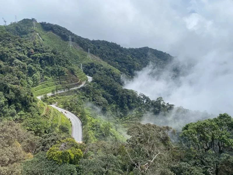
The Gunung Tahan trek is a masterclass in tropical endurance. While the elevation of 2,187 metres might seem modest compared to Himalayan or Andean peaks, the cumulative elevation gain and loss over the 55-kilometre route often exceeds 5,000 metres due to the undulating nature of the ridges. The trail is a relentless sequence of steep ascents and knee-jarring descents, often requiring the use of tree roots as natural ladders and navigating through thick mud that can reach mid-calf depth after heavy tropical downpours. This is a landscape where the environment is constantly trying to reclaim the path; fallen trees, overgrown rattan with its hooked thorns, and the ever-present humidity create a trekking experience that is as much about navigation and survival skills as it is about physical movement.
The journey is typically divided into two distinct halves. The first half, starting from the Merapoh trailhead (Sungai Relau), involves a steady climb through the "mossy forest" zones. Here, the air cools significantly, and every surface is draped in thick, emerald-green moss. The terrain is characterized by the "Gedung" and "Belumut" ridges, where the views open up to reveal the vast, unbroken green canopy of Taman Negara stretching toward the horizon. The second half of the trek, the descent toward Kuala Tahan, is arguably the more difficult section. It involves the infamous "27 hills" (Bukit Berdarah), a series of ridges that must be crossed in the heat of the lowland jungle. This section also requires multiple crossings of the Tahan River, which can range from ankle-deep crystal streams to waist-high torrents depending on recent rainfall.
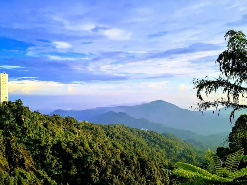
Wildlife encounters are a hallmark of the Tahan experience. While the elusive Malayan tiger and Asian elephant inhabit these forests, they are rarely seen by hikers. However, the presence of fresh tracks, the haunting call of the gibbons at dawn, and the vibrant plumage of hornbills flying overhead serve as constant reminders that you are a guest in a truly wild sanctuary. The trek is also famous for its smaller inhabitants—leeches, bees, and various insects—which require constant vigilance. Despite the hardships, the reward of standing on the summit at dawn, watching the sun rise over a sea of clouds that hide the oldest jungle on Earth, is a spiritual experience that few other trails can provide. It is a badge of honour for any serious trekker in the region.
History and Cultural Context
The history of Gunung Tahan is deeply intertwined with the indigenous Batek people, a nomadic hunter-gatherer group who have inhabited the Taman Negara region for millennia. To the Batek, the mountain and its surrounding forests are not just a physical landscape but a spiritual realm inhabited by ancestral spirits and deities. They have traditionally used the lower slopes for foraging and hunting, possessing an intimate knowledge of the medicinal plants and water sources that are vital for survival in the deep jungle. While they rarely ventured to the very summit—viewing the high peaks with a mix of reverence and caution—their guidance was instrumental in early European explorations of the area.
The first recorded attempt by Europeans to reach the summit occurred in the late 19th century. In 1888, the explorer and botanist William Skeat led an expedition that, while failing to reach the peak, provided the first scientific descriptions of the mountain's unique flora. It wasn't until 1905 that a British expedition led by Herbert Robinson and Cecil Boden Kloss successfully reached the summit. Their journey was an epic of colonial-era exploration, taking weeks to hack through the dense undergrowth from the Kuala Tahan side. They were astonished by the sub-alpine vegetation they found at the top, which differed so radically from the lowland jungles below. This expedition laid the groundwork for the establishment of the King George V National Park in 1938, which was renamed Taman Negara after Malaysia gained independence in 1957.
During the Malayan Emergency (1948–1960), the dense forests around Gunung Tahan served as a hideout for communist insurgents, making the area a "black zone" restricted to civilians. It was only in the decades following the conflict that the mountain was reopened for recreation. Today, the trek is managed by PERHILITAN (the Department of Wildlife and National Parks), and the requirement for a licensed guide is a nod to both the difficulty of the terrain and the need to protect the fragile ecosystem. The mountain remains a symbol of Malaysian national pride, representing the rugged, unconquerable heart of the peninsula.
Want more background? Read extended notes on history and cultural context → Learn more
Seasonal Highlights and Weather Reality
The climate of Gunung Tahan is governed by the tropical monsoon cycle, and understanding these patterns is critical for a safe and successful trek. The mountain is strictly closed to all hikers from mid-November to mid-January each year. This period coincides with the peak of the Northeast Monsoon, which brings torrential, unrelenting rain to the eastern side of the peninsula. During this time, river levels in Taman Negara rise dangerously, trails become impassable mudslides, and the risk of flash flooding and landslides makes trekking impossible.
The best time to attempt the trek is during the dry season, which typically runs from February to September. February and March are often considered the "sweet spot," as the forest is lush from the recent rains, but the weather is generally stable and the humidity is slightly lower. During these months, the orchids and pitcher plants on the upper plateaus are often in bloom, providing a spectacular display of colour against the green moss. April to June sees a rise in temperature and humidity, making the lowland sections of the trek particularly draining. However, this is also the best time for birdwatching, as many species are active and vocal during the breeding season.
Weather on the mountain itself is notoriously unpredictable. Even in the height of the dry season, afternoon thunderstorms are common. These storms can be incredibly intense, with lightning and heavy rain that can drop the temperature on the summit plateau from 25°C to 10°C in a matter of minutes. At the summit, night-time temperatures can hover around 4°C to 8°C, a shocking contrast to the 32°C heat of the lowlands. Trekkers must be prepared for "four seasons in a day," carrying gear that can handle both extreme heat and damp, shivering cold. The mist is another constant companion; it can roll in at any time, reducing visibility to a few metres and making navigation on the plateau sections challenging without a guide or GPS.
Recommended Itinerary
7-Day Merapoh to Kuala Tahan Traverse
Day 1: Merapoh (Sungai Relau) to Kuala Juram to Camp Kor
- Distance: 13.5 km
- Elevation gain: 350 m
- Time: 5–6 hours
- Morning registration at the Merapoh Wildlife Office and briefing
- 4WD transfer from Sungai Relau to Kuala Juram (the actual trailhead)
- The trek begins with several river crossings of the Sungai Relau
- Relatively flat terrain through lowland dipterocarp forest
- Arrive at Camp Kor, situated beside a beautiful river perfect for a first-night swim
- First night of jungle sounds—expect a cacophony of insects and frogs
Day 2: Camp Kor to Camp Kubang
- Distance: 8 km
- Elevation gain: 800 m
- Time: 6–7 hours
- The real climbing begins as the trail leaves the river valley
- Steep ascent through the "mossy forest" transition zone
- The trail becomes narrower and more rugged, with many tree roots to navigate
- Pass through "Permatang," a ridge section with occasional views through the canopy
- Arrive at Camp Kubang (approx. 1,400 m), a small clearing in the montane forest
- Water source is a small stream about 5 minutes from the campsite
Day 3: Camp Kubang to Camp Belumut
- Distance: 7 km
- Elevation gain: 500 m
- Time: 5–6 hours
- Continued ascent along the ridge toward the higher peaks
- The vegetation changes to stunted trees and thick moss
- Pass through "Bonsai Garden," a beautiful area of naturally dwarfed trees
- Spectacular views of the Tahan massif if the weather is clear
- Arrive at Camp Belumut (approx. 1,800 m), often shrouded in mist
- Temperatures drop significantly here; evening warmth and dry clothes are essential
Day 4: Camp Belumut to Summit to Camp Gedung
- Distance: 6 km
- Elevation: 400 m gain to summit, 300 m descent to Gedung
- Time: 5–6 hours
- Final push to the summit of Gunung Tahan (2,187 m)
- The trail crosses an open, rocky plateau with unique sub-alpine flora
- Summit celebration and panoramic views of the entire Taman Negara range
- Descent toward the Kuala Tahan side to Camp Gedung
- Camp Gedung is located near a massive rock overhang, providing some shelter from wind
- This is the highest campsite on the trek and the coldest night
Day 5: Camp Gedung to Camp Teku
- Distance: 8 km
- Elevation: 1,200 m descent
- Time: 7–8 hours
- A long, punishing descent that tests knees and ankles
- The trail drops steeply from the sub-alpine zone back into the deep jungle
- Pass through "Gunung Tangga Dua Belas" (Twelve Ladder Mountain)
- The humidity increases rapidly as you lose elevation
- Arrive at Camp Teku, located at the confluence of the Teku and Tahan Rivers
- Camp Teku is a large, sandy site and a favourite for its deep swimming holes
Day 6: Camp Teku to Camp Melantai
- Distance: 12 km
- Elevation: Multiple ridge crossings (the "27 hills")
- Time: 8–10 hours
- The most psychologically demanding day of the trek
- The trail follows the Tahan River but frequently climbs over steep ridges to avoid bends
- Known as "Bukit Berdarah" (Bloody Hills) due to the effort required and the leeches
- Multiple river crossings—boots will be wet for the remainder of the day
- Arrive at Camp Melantai, a lowland site with high humidity and many insects
- Final night in the jungle; a sense of accomplishment begins to set in
Day 7: Camp Melantai to Kuala Tahan
- Distance: 12 km
- Elevation: Mostly flat with minor undulations
- Time: 4–5 hours
- The final stretch through primary lowland rainforest
- The trail is wider and easier to follow as you approach the park headquarters
- Pass through areas with massive tualang trees and giant bamboo
- Arrive at Kuala Tahan (Taman Negara HQ) by early afternoon
- Check out at the Wildlife Office and receive your achievement certificate
- Celebratory meal at the floating restaurants on the Tembeling River
Important Notes:
- The itinerary is subject to change based on river levels and weather conditions
- A licensed guide is mandatory for this trek and will manage the pace and safety
- Campsites are basic clearings; all waste must be carried out
- River crossings can be dangerous after rain; always follow the guide's instructions
- Leech activity is highest in the lowland sections (Days 1, 6, and 7)
Planning and Bookings
Book Your Trip
Everything you need to plan your journey
Accommodation
Find places to stay near Jerantut
Flights
Search flights to Jerantut
Essential Preparation
Planning for Gunung Tahan requires a lead time of at least three to six months. The primary constraint is the availability of licensed guides and the limited number of permits issued by PERHILITAN. You must first decide on your route: the Merapoh-Kuala Tahan traverse (55 km), the Kuala Tahan return (approx. 100 km), or the Merapoh return (approx. 32 km). The traverse is the most popular for international trekkers as it offers the most variety.
Physical preparation is non-negotiable. This is not a trek for beginners. You should be comfortable hiking for 8–10 hours a day with a 12–15 kg pack in high heat and humidity. Training should include stair climbing, hill repeats, and multi-day hikes to break in your boots and test your gear. Logistically, Jerantut is the main gateway. From Kuala Lumpur, you can take a bus or train to Jerantut, and then a local taxi or bus to either Merapoh or Kuala Tahan. Most trekkers arrange their entire package (guide, permits, 4WD transfers) through a registered trekking agency in Jerantut or Kuala Tahan.
Trail Accommodation
There are no huts, lodges, or permanent shelters on the Gunung Tahan trek. Accommodation consists entirely of wilderness campsites. These are designated clearings in the jungle, often near water sources, where you must pitch your own tent or set up a flysheet and groundsheet system.
Campsite Facilities:
- Flat (or relatively flat) ground for tents
- Access to a natural water source (river or stream)
- No toilets—hikers must follow strict "cat hole" procedures at least 50 metres from water
- No rubbish bins—everything must be packed out
- No electricity or mobile signal
Booking Requirements:
- Campsites are included in your trekking permit
- Your guide will usually coordinate which sites to use based on the group's pace
- During peak months (July–August), campsites can become crowded; early arrival is advised
- Cost: Included in the overall permit and guide package, which typically ranges from RM1,500 to RM2,500 per person depending on group size and inclusions
Required Gear
- Trekking boots - Must have excellent grip for mud and wet rocks. "Kampung Adidas" (local rubber shoes) are popular with guides but require tough feet.
- Leech socks - Essential for the lowland sections to prevent bites and infections.
- Backpack - 50–65L with a high-quality rain cover and internal waterproof liners (dry bags).
- Lightweight tent or flysheet/groundsheet - Must be 100% waterproof and have a bug net.
- Sleeping bag - A lightweight 2-season bag (rated to 5°C) is sufficient for the higher camps.
- Waterproof jacket - A breathable shell for the summit plateau and sudden downpours.
- Head torch - Essential for camp life and potential night hiking; bring spare batteries.
- Personal First Aid Kit - Include antiseptic cream, antihistamines, rehydration salts, and blister care.
- Trekking poles - Highly recommended for the steep descents and river crossings.
What to Bring
- Food for 7 days - Lightweight, high-calorie rations (dehydrated meals, instant noodles, nuts, chocolate, sardines). Most guides will help coordinate group meals.
- Water treatment - Purification tablets or a high-quality filter (e.g., Sawyer Squeeze). While river water is generally clean, upstream contamination is possible.
- Cooking equipment - Lightweight gas stove, fuel canisters (available in Jerantut), and a nesting pot set.
- Clothing - Moisture-wicking synthetic fabrics. Avoid cotton, which never dries in the humidity. Bring one dedicated set of "dry clothes" strictly for sleeping.
- Sun and insect protection - SPF50+ sunscreen, hat, and high-DEET insect repellent.
- Biodegradable toiletries - Small towel, soap, toothbrush, and plenty of toilet paper in waterproof bags.
- Power bank - To keep your phone/GPS charged for the duration of the trek.
Permits
All trekkers entering Taman Negara for the Gunung Tahan climb must obtain a permit from the Department of Wildlife and National Parks (PERHILITAN). The permit system is designed to monitor the number of people on the mountain and ensure that everyone is accompanied by a licensed guide, which is a legal requirement.
Permit Process:
- Permits must be applied for at least 30 days in advance, though 60 days is safer during peak season.
- Applications are usually handled by your trekking agency or guide. You will need to provide a copy of your passport and a basic medical declaration.
- Upon arrival at the Merapoh or Kuala Tahan Wildlife Office, you must present your permit for verification and attend a mandatory safety briefing.
- You will also be required to declare all "non-biodegradable" items (tins, plastic bottles, etc.) which will be checked again upon your return to ensure no litter was left behind.
Costs (Subject to change):
- Park Entrance Permit: RM1.00 per person
- Gunung Tahan Climbing Permit: RM10.00 per person
- Camera License: RM5.00 per camera (including smartphones used for photos)
- Camping Fee: RM1.00 per person per night
- Guide Fees: This is the largest expense, typically RM250–RM400 per day, shared among the group (maximum 7–10 trekkers per guide).
Important Note: The "Trash Declaration" is taken very seriously. Failure to produce the items you declared at the start can result in heavy fines or the withholding of your climbing certificate. This system has been highly effective in keeping Gunung Tahan one of the cleanest trails in Malaysia.
Other Activities in the Area
Taman Negara is a massive park with much more to offer than just the Tahan trek. Consider adding a few days to your itinerary to experience the following:
- Canopy Walkway: Located near Kuala Tahan, this is one of the longest suspension bridges in the world, hanging 40 metres above the forest floor. It offers a unique perspective on the rainforest layers.
- Night Jungle Walk: Guided walks from Kuala Tahan allow you to see nocturnal creatures like flying squirrels, slow lorises, and various phosphorescent fungi.
- Rapid Shooting: Take a wooden longboat up the Tembeling River for a thrilling ride through seven sets of rapids. Be prepared to get soaked!
- Visit an Orang Asli Village: Learn about the traditional lifestyle of the Batek people, including blowpipe demonstrations and fire-making skills. Please ensure your visit is through an ethical tour operator.
- Lata Berkoh: A scenic boat trip to a series of cascades and deep pools on the Tahan River, perfect for a relaxing swim after your trek.
- Gua Telinga (Ear Cave): For those not claustrophobic, this cave system offers a chance to see bats and unique cave insects (check current accessibility as it is sometimes closed for safety).
Safety and Conditions
River Crossings: The Tahan River is the lifeblood of the trek but also its greatest danger. After heavy rain, the river can rise several metres in a matter of hours. Never attempt to cross a swollen river without your guide's approval. If the water is above waist height or moving too fast, the only safe option is to wait for the levels to drop, which usually happens within 12–24 hours of the rain stopping.
Heat and Hydration: The combination of high temperatures (30°C+) and extreme humidity (90%+) leads to rapid fluid loss. Heat exhaustion and heatstroke are genuine risks. Drink at least 4–5 litres of water per day and use electrolyte replacement salts. Monitor your urine colour; if it's dark, you are dangerously dehydrated.
Leeches and Infections: While leeches are more of a nuisance than a danger, their bites can easily become infected in the humid environment. Clean all bites thoroughly with antiseptic. Small cuts or scratches from thorns can also turn into tropical ulcers if not treated immediately. Keep your skin as dry as possible at camp.
Wildlife Safety: While large predators are rare, you are in their territory. Always keep a clean campsite and store food securely to avoid attracting macaques or wild boar. If you encounter an elephant, stay calm, do not make sudden movements, and follow your guide's instructions to back away slowly.
Emergency Evacuation: There is no helicopter rescue service for Gunung Tahan. In the event of a serious injury, the only way out is to be carried by a rescue team or, if near a river, evacuated by boat. This can take days. Ensure you have comprehensive travel insurance that covers "high-altitude trekking" and "wilderness search and rescue."
Side Trips and Points of Interest
Gunung Gedung: Often visited on Day 4 or 5, this secondary peak (2,065 m) offers some of the best views of the Tahan summit itself. The ridge between Gedung and Tahan is a stunning stretch of sub-alpine plateau, filled with pitcher plants (Nepenthes) and unique mountain shrubs. It is a photographer's paradise when the morning mist clears.
The Bonsai Gardens: Located between Camp Kubang and Camp Belumut, these are natural clearings where the soil is too thin to support large trees. The result is a collection of ancient, gnarled trees that look like carefully tended bonsai. It is one of the most ethereal landscapes in Malaysia.
Lembah Teku (Teku Valley): The valley surrounding Camp Teku is a deep, prehistoric-looking canyon. The confluence of the rivers here is a place of immense natural beauty. Many trekkers consider this the most beautiful campsite on the route, despite the sandflies.
The 27 Hills (Bukit Berdarah): While technically part of the main trail, this section is a "point of interest" for its sheer difficulty. Each hill has its own character, and reaching the final hill before the descent to Melantai is a major psychological milestone for every Tahan trekker.
Leave No Trace
Taman Negara is a sanctuary for some of the rarest species on Earth. The impact of hundreds of trekkers each year can be devastating if Leave No Trace principles are not strictly followed. The "Trash Declaration" system is a start, but true conservation requires a personal commitment from every hiker.
Core Principles for Gunung Tahan:
- Pack it in, pack it out: This includes cigarette butts, fruit peels, and even biodegradable tissue paper, which takes a long time to decompose in the jungle.
- Respect the water: Do not use soap or shampoo directly in the rivers. Carry water 50 metres away from the source for washing.
- Stay on the trail: The mossy forest is incredibly fragile. Stepping off the trail can crush rare plants and compact the soil, leading to erosion.
- No campfires: Use a gas stove for cooking. Campfires scar the ground and use up fallen wood that is essential for the forest's nutrient cycle.
- Sanitation: Use the "cat hole" method for human waste. Dig a hole 15–20 cm deep and at least 50 metres from any water source or campsite. Bury it completely.
- Wildlife: Never feed any animals. This disrupts their natural foraging behaviour and can make them aggressive toward future trekkers.