Gulf Islands Coastal Path - A Salish Sea Odyssey
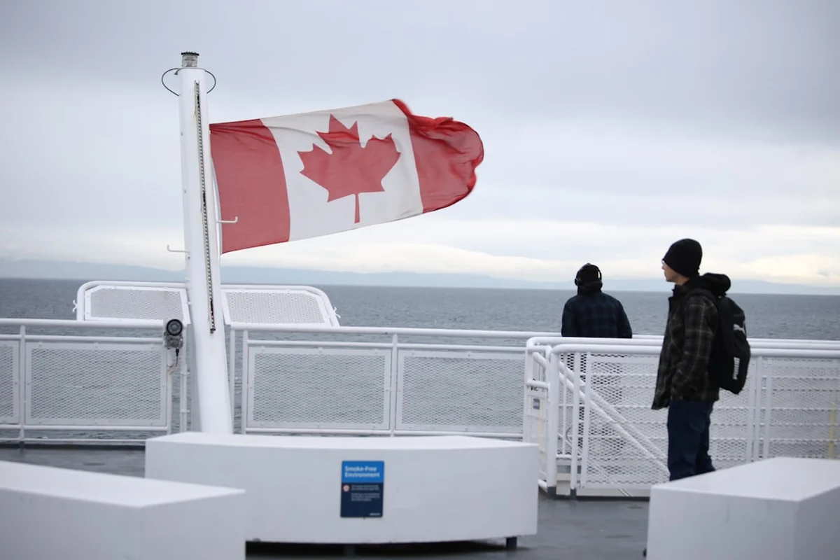
The Gulf Islands Coastal Path is a breathtaking multi-day journey through the heart of the Salish Sea, weaving together the rugged shorelines, emerald forests, and sun-drenched ridges of Canada’s Southern Gulf Islands. Spanning approximately 78 kilometres across an archipelago known for its unique "Mediterranean" microclimate, this route offers a hiking experience unlike any other in North America. Unlike traditional linear trails, the Coastal Path is a curated odyssey that utilizes the region’s intricate ferry system to link the most spectacular coastal segments of Galiano, Mayne, and the Pender Islands. It is a journey through a landscape defined by the tides, where the scent of salt air mingles with the resinous perfume of Douglas fir and the peeling red bark of the iconic Arbutus tree. This is not merely a walk; it is an immersion into a delicate island ecosystem where the pace of life is dictated by the rhythm of the water and the arrival of the next ferry.
- Distance: 78.0 km (combined trail segments and connecting routes)
- Duration: 4–5 days
- Season: May to September (optimal dry season; accessible year-round with preparation)
- Accommodation: Provincial Park campsites, National Park Reserve sites, and local inns
- Highest point: Mount Galiano (311 m) and Mount Norman (244 m)
- Difficulty: Moderate (varied terrain from flat coastal walks to steep ridge climbs)
- Direction: Flexible, typically travelled North to South (Galiano to Pender)
Overview
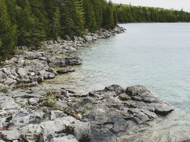
The Gulf Islands Coastal Path represents the pinnacle of island trekking in British Columbia. Situated in the rain shadow of Vancouver Island’s mountains and the Olympic Peninsula, these islands enjoy significantly less rainfall than the nearby mainland, creating a sanctuary for rare flora and fauna. The trail system is a masterclass in ecological diversity. One hour you may find yourself traversing a windswept sandstone gallery where the waves have carved intricate honeycombs into the rock; the next, you are climbing through a Garry oak meadow—one of the most endangered ecosystems in Canada—where wildflowers like camas and chocolate lilies bloom in profusion during the spring months.
The experience is defined by its "broken" nature. Because the path spans multiple islands, the logistics of the journey become part of the adventure. Hikers must navigate the waters of Active Pass and Navy Channel, often spotting pods of Southern Resident Killer Whales (Orcas), humpback whales, or playful harbour seals from the deck of the ferry. On land, the trails range from the soft, needle-carpeted floors of old-growth forests to the exposed, sun-baked ridges of Mount Galiano, which offers a 360-degree panorama of the San Juan Islands in the United States and the snow-capped peaks of the Coast Mountains on the Canadian mainland.
While the elevation gain of 1,200 metres may seem modest compared to alpine treks, the "island miles" are earned through constant undulations and technical coastal sections. The terrain is often rocky and root-filled, requiring steady footwork. However, the reward is a sense of profound isolation and connection to the marine environment. In the evenings, the sun sets over the Salish Sea in a riot of orange and purple, and the bioluminescence in the water often provides a magical light show for those camping near the shore. This is a trail for the soul—a place to disconnect from the digital world and reconnect with the elemental forces of stone, sea, and sky.
History and Cultural Context
The Gulf Islands, or the Southern Gulf Islands, are the ancestral and unceded territories of the Coast Salish peoples, including the Hul’qumi’num and SENĆOŦEN speaking nations. For thousands of years, these islands were not "wilderness" but a managed and highly productive landscape. The indigenous peoples established permanent winter villages and seasonal summer camps throughout the archipelago, utilizing the rich marine resources and terrestrial plants. Evidence of this long-standing relationship is visible today in the form of ancient shell middens—layers of discarded shells and organic material that have built up over millennia—and the presence of "sea gardens" or clam gardens, which were rock walls constructed in the intertidal zone to enhance shellfish productivity. The trails used today often follow the same ridgelines and coastal access points that have been used for generations for hunting, gathering, and spiritual practice.
European contact in the late 18th century brought Spanish and British explorers, whose names still dot the charts: Galiano, Valdes, and Vancouver. The 19th century saw the arrival of settlers who established orchards, sandstone quarries, and fishing outposts. Galiano Island, in particular, became known for its high-quality sandstone, which was used to build many of the historic buildings in Victoria and Vancouver. The development of the islands remained relatively slow compared to the mainland, preserved by the very water that made access difficult. This isolation allowed for the preservation of significant tracts of forest and coastline.
In 2003, the creation of the Gulf Islands National Park Reserve marked a turning point in the conservation of the region. This "patchwork" park protects over 35 square kilometres of land and water across 15 islands and numerous islets. The Coastal Path utilizes many of these protected areas, as well as provincial parks like Montague Harbour and Dionisio Point. Walking this path is a journey through time, where one can see the scars of old logging roads being reclaimed by the forest, the remnants of pioneer orchards, and the enduring presence of the Coast Salish people who continue to act as stewards of these islands.
Want more background? Read extended notes on history and cultural context → Learn more
Seasonal Highlights and Weather Reality
The Gulf Islands are famous for their "Mediterranean" climate, characterized by warm, dry summers and mild, wet winters. This makes the Coastal Path a viable option for much of the year, though the experience changes dramatically with the seasons.
Summer (June to August): This is the peak season for the Coastal Path. The weather is consistently sunny, with temperatures ranging from 20°C to 28°C. The sea breezes provide a cooling effect, making for pleasant hiking conditions. This is the best time for swimming in the refreshing (if chilly) waters of the Salish Sea and for spotting marine wildlife. However, this is also the busiest time for ferries and campsites, requiring bookings months in advance. Water sources on the islands can dry up in late summer, making water management a critical safety concern.
Spring (April to May): Many locals consider this the best time to hike. The islands erupt in a spectacular display of wildflowers, particularly in the Garry oak meadows. The temperatures are mild (12°C to 18°C), and the air is crisp. While there is a higher chance of rain than in summer, the landscapes are lush and vibrant green. Migratory birds return to the islands, making it a paradise for birdwatchers.
Autumn (September to October): September offers the "Indian Summer" of the Gulf Islands, with warm days and cool, misty mornings. The crowds thin out, and the light takes on a golden, ethereal quality. By October, the rains begin to return, and the deciduous trees, like the Bigleaf Maple, provide splashes of yellow and orange against the evergreen backdrop.
Winter (November to March): While the islands rarely see significant snow, they receive the bulk of their annual precipitation during these months. Trails can become muddy and slippery, and the days are short. However, for the experienced hiker, winter offers a sense of total solitude. The ferries are quiet, and the dramatic winter storms provide a powerful perspective on the raw beauty of the coast. Proper waterproof gear and a high tolerance for dampness are essential.
Recommended Itinerary
5-Day Gulf Islands Coastal Path Itinerary
Day 1: Galiano North - The Wild Coast
- Distance: 14 km
- Elevation gain: 250 m
- Time: 5–6 hours
- Arrive at Sturdies Bay (Galiano Island) via ferry from Swartz Bay
- Transport to the northern end of Galiano (shuttle or taxi)
- Hike from Bodega Ridge Provincial Park to Dionisio Point Provincial Park
- Traverse high ridges with views over the Trincomali Channel
- Descend into the lush forest of the north end
- Arrive at Dionisio Point (walk-in/boat-in camping only)
- Explore the unique "gallery" sandstone formations at the water's edge
- This day offers the most remote feeling of the entire trip, with no road access to the campsite
Day 2: Galiano Central - Ridges and Harbours
- Distance: 18 km
- Elevation gain: 400 m
- Time: 6–7 hours
- Hike south from Dionisio Point toward the centre of the island
- Follow a mix of forest trails and quiet backroads to reach Mount Galiano
- Summit Mount Galiano (311 m) for the best views in the Gulf Islands
- Descend toward Montague Harbour Marine Provincial Park
- Arrive at Montague Harbour campsite
- Visit the famous "White Shell Beach," an ancient midden site
- Enjoy a sunset over the harbour, a popular spot for sailors and kayakers
Day 3: Mayne Island - The Heart of the Pass
- Distance: 12 km
- Elevation gain: 200 m
- Time: 4–5 hours
- Morning ferry from Sturdies Bay (Galiano) to Village Bay (Mayne Island)
- Hike from Village Bay to Mount Parke Regional Park
- Climb to the viewpoint overlooking Active Pass—watch the ferries navigate the narrow gap
- Continue through the island's interior to Georgina Point Lighthouse
- Explore the heritage orchards and the Japanese Memorial Garden
- Stay at a local inn or B&B (Mayne has limited public camping)
- This day is shorter, allowing time to enjoy the local culture and artisan shops of Mayne
Day 4: North Pender - The High Points
- Distance: 16 km
- Elevation gain: 300 m
- Time: 5–6 hours
- Morning ferry from Village Bay (Mayne) to Otter Bay (Pender Island)
- Hike from Otter Bay toward the Roesland unit of the National Park Reserve
- Visit the historic Roe House and the beautiful Roe Lake
- Continue south to Mount Norman, the highest point on the Penders
- Steep climb to the summit for views of the San Juan Islands and South Pender
- Descend to Shingle Bay campsite (National Park Reserve)
- A challenging day with significant elevation but rewarding vistas
Day 5: South Pender - The Southern Tip
- Distance: 18 km
- Elevation gain: 50 m
- Time: 5–6 hours
- Cross the wooden bridge connecting North and South Pender
- Hike the coastal trails of South Pender, including Gowlland Point and Brooks Point Regional Park
- Brooks Point offers spectacular meadows and chocolate lily blooms in spring
- Walk the rugged shoreline with views across the Juan de Fuca Strait to the Olympic Mountains
- Finish the journey at the southern tip of the island
- Return to Otter Bay for the ferry back to Swartz Bay (Victoria)
- A relatively flat but long final day focused on the dramatic marine boundary
Important Notes:
- Ferry schedules are seasonal and must be checked daily; "inter-island" ferries can be infrequent
- Water is scarce on the islands; always carry at least 2–3 litres and treat all wild water
- Campsites at Montague Harbour and Dionisio Point fill up months in advance
- The route involves some road walking on quiet, paved island roads to connect trailheads
- Cell service is generally good on ridges but can be non-existent in valleys and remote coves
- Respect private property; many trails border residential land
Planning and Bookings
Book Your Trip
Everything you need to plan your journey
Accommodation
Find places to stay near Victoria
Flights
Search flights to Victoria
Essential Preparation
The Gulf Islands Coastal Path requires more logistical coordination than a standard wilderness trek due to the reliance on BC Ferries. Your itinerary is essentially built around the ferry schedule. It is vital to download the BC Ferries app and monitor real-time departures, as delays are common in the summer. Fitness requirements are moderate; while there are no high-altitude passes, the constant "up and down" of coastal terrain and the weight of a multi-day pack require good cardiovascular health and leg strength.
Victoria serves as the primary gateway. Most hikers fly into Victoria International Airport (YYJ) or arrive via ferry from Vancouver (Tsawwassen). Before heading to the islands, stock up on all specialized gear and dehydrated food in Victoria, as island grocery stores are small and expensive. Base yourself in the Sidney or Swartz Bay area the night before your start to catch the earliest possible ferry to Galiano Island.
Trail Accommodation
Accommodation on the Coastal Path is a mix of provincial parks, national park reserves, and private options. Because the islands are popular tourist destinations, you cannot simply "wild camp" anywhere; you must stay in designated areas.
Huts and Shelters: There are no hiking huts or shelters on this trail. You must carry a tent or book roofed accommodation.
Key Campsites:
- Dionisio Point (Galiano): Walk-in only. No potable water. Pit toilets provided. This is a rugged, beautiful site on the northern tip.
- Montague Harbour (Galiano): A major provincial park. Offers potable water, pit toilets, and a small seasonal shop nearby. Very popular; bookings essential.
- Prior Centennial (North Pender): Part of the National Park Reserve. Forested sites with potable water and pit toilets.
- Shingle Bay (North Pender): National Park Reserve. Oceanfront sites, walk-in only. No potable water (must bring or treat).
Booking Requirements: BC Parks (Montague, Dionisio) and Parks Canada (Prior Centennial, Shingle Bay) use online reservation systems. Bookings for the summer season typically open in early spring and sell out within minutes for weekends. Costs range from $10 to $30 per night depending on the site and residency status.
Required Gear
- Hiking Boots: Sturdy, waterproof boots with good ankle support. The sandstone can be slippery when wet, and forest trails are often root-heavy.
- Rain Shell: A high-quality waterproof jacket (Gore-Tex or similar). Even in summer, coastal mists and sudden showers are possible.
- Backpack: 50–65L capacity with a proper suspension system and rain cover.
- Navigation: A physical map of the islands (available at local shops) and an offline GPS app (like Gaia GPS or AllTrails). Trail marking can be inconsistent.
- Sleep System: A 3-season tent, a sleeping pad with a good R-value (ground can be cold), and a sleeping bag rated to 0°C.
- Sun Protection: High-SPF sunscreen, a wide-brimmed hat, and polarized sunglasses for the intense glare off the water.
What to Bring
- Water Treatment: A reliable filter (Sawyer Squeeze or Katadyn BeFree) or purification tablets. Many campsites do not have potable water.
- Food: All meals for the duration. While you can buy snacks at island stores, they are not always on the trail route. High-calorie, lightweight options are best.
- Stove and Fuel: A lightweight canister stove (Jetboil or MSR PocketRocket). Check fire bans before leaving; during summer, charcoal and wood fires are strictly prohibited.
- Power Bank: To keep your phone/GPS charged, as there are no outlets at campsites.
- First Aid: Including blister care (moleskin/Leukotape), antiseptic wipes, and tweezers for tick removal.
- Dry Bags: To keep your clothes and sleeping bag dry inside your pack during ferry crossings or rain.
Permits
There is no single "trail permit" for the Gulf Islands Coastal Path. Instead, your "permits" consist of your individual campsite reservations and your ferry tickets. Because the path crosses through various jurisdictions (BC Parks, Parks Canada, and Regional Parks), you must manage multiple booking platforms.
Campsite Reservations:
- BC Parks: Reservations for Montague Harbour and Dionisio Point are made through the "Discover Camping" website. You can book up to 4 months in advance of your arrival date.
- Parks Canada: Reservations for Pender Island sites (Prior Centennial, Shingle Bay) are made through the Parks Canada Reservation Service. These typically open in January or February for the entire upcoming season.
- Regional Parks: Sites like Brooks Point are day-use only; no permits required for hiking, but overnighting is prohibited.
Ferry Logistics:
- Ferry travel between the islands (e.g., Galiano to Mayne) is on a first-come, first-served basis for foot passengers. You do not need to book these in advance, but you must arrive at the terminal at least 30 minutes before departure.
- The main ferry from the mainland (Tsawwassen) to the islands *can* be booked in advance and is highly recommended for weekend travel.
- Keep your paper tickets or digital QR codes handy; some inter-island segments are free if you have a transfer from a main route, but policies change frequently.
Costs: Expect to spend approximately $150–$250 per person on a 5-day trip, covering all campsite fees and ferry transfers. This does not include food or transport to the ferry terminals.
Other Activities in the Area
The Gulf Islands are a vibrant cultural and recreational hub. If you have extra time, consider these additions:
- Sea Kayaking: Rent a kayak at Montague Harbour or Port Browning. Paddling the shoreline offers a completely different perspective on the sandstone caves and kelp forests.
- Whale Watching: Several ethical operators run tours out of Sidney or Galiano. The Salish Sea is one of the best places in the world to see Orcas and Humpbacks.
- Artisan Markets: The Saturday Market on Salt Spring Island (a short ferry ride away) is world-famous for its local crafts, cheeses, and organic produce.
- Cider and Wine Tasting: Pender and Mayne Islands have small, award-winning cideries and vineyards that offer tastings in beautiful pastoral settings.
- Disc Golf: Pender Island is home to one of the most highly-rated disc golf courses in the world—a 27-hole forest course that is free to play.
Safety and Conditions
Water Scarcity: This is the most significant safety risk on the Gulf Islands. Many islands experience severe drought in the summer. Do not rely on seasonal creeks marked on maps; they are often dry by July. Always carry more water than you think you need, and refill at every available potable source (marked in provincial parks).
Wildlife: While there are no grizzly bears or wolves on the Southern Gulf Islands, there is a small population of cougars and black bears (mostly on Galiano). More common are the hyper-abundant black-tailed deer, which can be bold around campsites. Store all food in bear-resistant containers or hang it to prevent attracting rodents and raccoons. Ticks are prevalent in the tall grasses and Garry oak meadows; check your body daily for ticks, as some carry Lyme disease.
Terrain and Weather: The sandstone cliffs can be extremely slippery when wet or covered in algae. Stay well back from cliff edges, as the rock can be crumbly. Heat exhaustion is a risk on the exposed ridges of Mount Galiano and Mount Norman; hike these sections in the early morning during heatwaves.
Ferry Reliability: Ferries can be cancelled due to high winds or mechanical issues. Always have a "Plan B" and enough extra food for 24 hours in case you are stranded on an island longer than expected.
Emergency Services: Dial 911 for emergencies. Each island has a volunteer fire department and a small medical clinic, but serious injuries will require a helicopter evacuation to Victoria or Vancouver.
Side Trips and Points of Interest
Mount Galiano Summit: While part of the main itinerary, this is the "must-do" side trip if you are staying at Montague Harbour. The trail is well-maintained but steep. At the top, you are rewarded with a view that encompasses the entire San Juan archipelago and the Olympic Mountains. It is the perfect spot for a sunrise breakfast.
Georgina Point Lighthouse (Mayne Island): Located at the entrance to Active Pass, this historic lighthouse (built in 1885) is a prime spot for land-based whale watching. The currents in the pass are incredibly strong, and you can often see seals and sea lions struggling against the tide.
The "Hole in the Wall" (Galiano): A natural sea arch located near the northern end of the island. It requires a bit of scrambling at low tide to reach, but it is one of the most photographed geological features in the islands.
Roesland and Roe Lake (Pender): A peaceful detour into a freshwater ecosystem. Roe Lake is a rare upland lake on the islands, surrounded by lilies and home to a variety of waterfowl. The historic Roe House nearby provides a glimpse into the early 20th-century resort life on the islands.
Leave No Trace
The Gulf Islands ecosystem is incredibly fragile. The thin soils on the rocky ridges are easily eroded, and the rare plants found here can be destroyed by a single misplaced footstep. As a hiker, you are a guest in a sensitive biological sanctuary.
Core Principles for the Islands:
- Stay on the Trail: This is non-negotiable in Garry oak meadows and on sandstone bluffs. Off-trail hiking destroys the cryptogamic crust (soil bacteria) and rare wildflowers.
- Pack It Out: There is no trash collection on the trails or at remote campsites. Every piece of plastic, every orange peel, and every bit of micro-trash must go back with you to the ferry terminal bins.
- Respect the Middens: Many beaches are ancient indigenous heritage sites. Do not dig in the white shell fragments or remove any artifacts. These are protected by the Heritage Conservation Act.
- Fire Safety: Use only contained gas stoves. Never build a campfire on a beach or in the forest. The islands are a tinderbox in the summer, and a single spark could devastate the community.
- Human Waste: Use the provided pit toilets at all times. If you are caught between sites, use a "pack-out" bag (WAG bag) or dig a cathole at least 60 metres from any water source or trail, though packing it out is preferred in this dry environment.