Grizzly Lake Trail
The Grizzly Lake Trail is a challenging mountain track located in the remote and rugged Tombstone Mountains of Yukon, Canada. This demanding route offers a true wilderness experience, traversing alpine meadows, rocky slopes, and high mountain passes to reach the stunning, turquoise waters of Grizzly Lake. It is a journey for experienced hikers seeking solitude, dramatic landscapes, and the raw beauty of the subarctic wilderness. The trail is not for the faint of heart, requiring significant physical fitness, excellent navigation skills, and a high degree of self-sufficiency. Prepare for unpredictable weather, challenging terrain, and the profound sense of accomplishment that comes from conquering this remote Yukon gem.
- Distance: 23.0 km one-way
- Elevation Gain: 850 m
- Duration: 2-3 days
- Difficulty: Challenging
- Best Time: May-October
- Closest City: Tombstone Mountains (closest major centre is Dawson City)
- Trailhead Access: Nearest airport: Dawson City (YDA). Drive north on Dempster Highway. The trailhead is located approximately 70km north of the Tombstone Interpretive Centre. Road is gravel; check conditions. Parking available. No permits needed for day hikes, camping requires registration at the Tombstone Interpretive Centre.
- Coordinates: 64.5066, -138.2206
Overview
The Grizzly Lake Trail is a testament to the untamed beauty of the Tombstone Mountains, a range renowned for its unique geological formations, vibrant alpine flora, and the chance to witness wildlife in its natural habitat. This trail is not a manicured path; it is a rugged expedition that demands respect for the wilderness. The journey begins with a gradual ascent, gradually revealing panoramic vistas of the surrounding peaks and valleys. As you gain elevation, the landscape transforms from subalpine forest to open tundra, dotted with wildflowers in the summer months.
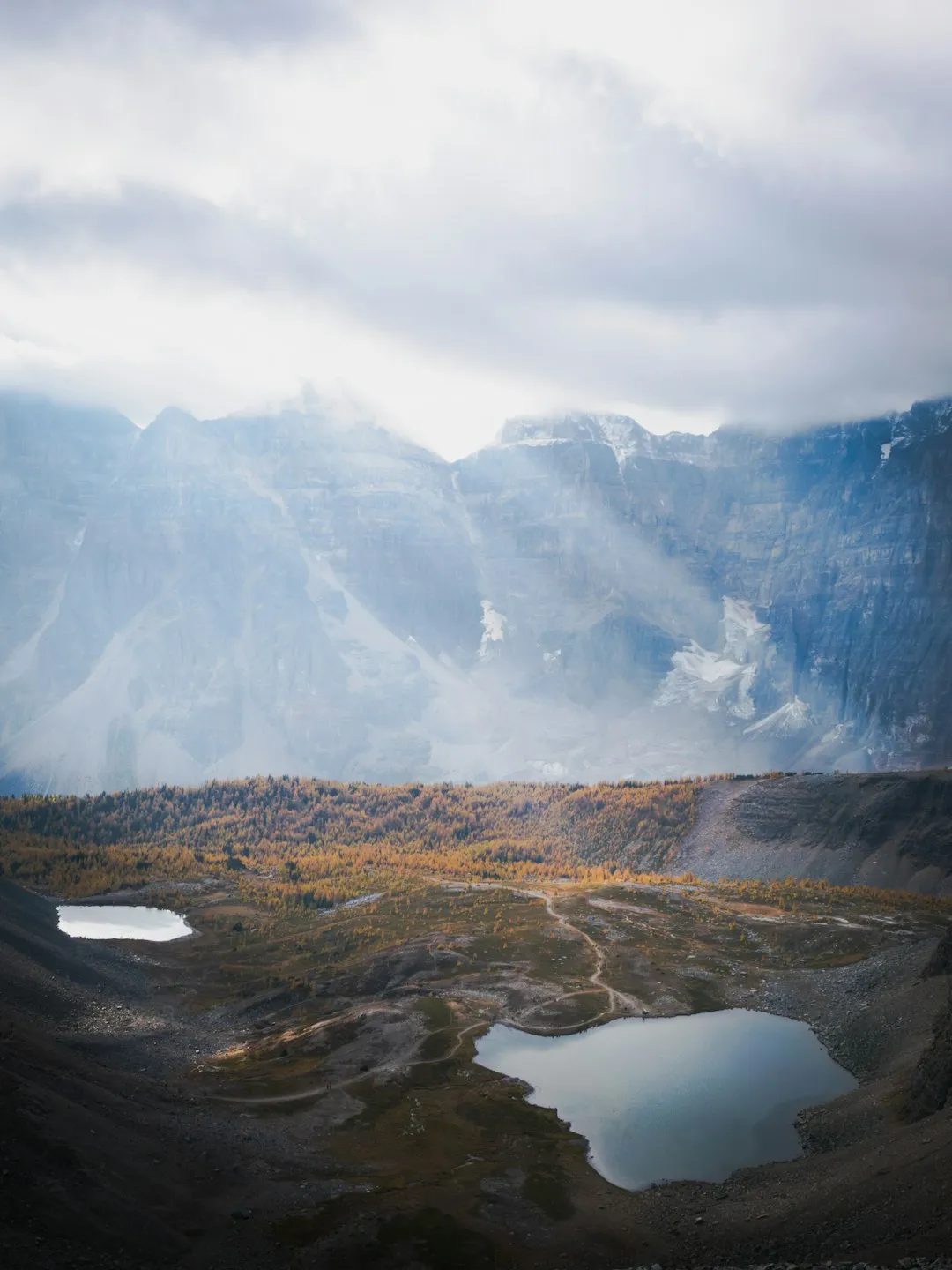
The trail's defining feature is its challenging nature. Expect steep, sustained climbs, rocky scree slopes, and potentially boggy sections, especially after rain. Navigation can be tricky in places, requiring keen attention to cairns and the natural contours of the land. The reward for this effort is immense: the breathtaking sight of Grizzly Lake, a glacial tarn nestled beneath towering, jagged peaks. The lake's vibrant turquoise colour, a result of glacial silt, is a stark contrast to the surrounding grey rock and green tundra. Camping near the lake offers an unparalleled opportunity to immerse yourself in this remote alpine environment, with the potential for wildlife sightings, including caribou, Dall sheep, and, of course, grizzly bears.
This trail is best suited for experienced backpackers who are comfortable with off-trail navigation, self-sufficiency, and carrying all necessary gear for multi-day excursions. The remoteness of the Tombstone Mountains means that rescue services are limited, and self-reliance is paramount. The best time to tackle the Grizzly Lake Trail is during the short Yukon summer, when the snow has receded from the higher passes and the tundra is in bloom. Even then, weather can change rapidly, so preparedness for all conditions is essential.
History and Cultural Context
The Tombstone Mountains, and the land upon which the Grizzly Lake Trail traverses, hold deep cultural significance for the Tr'ondëk Hwëch'in First Nation. This region has been a traditional territory for millennia, used for hunting, gathering, and spiritual practices. The unique geological formations, including the iconic Tombstone itself, are imbued with ancestral stories and a profound connection to the land. While the Grizzly Lake Trail is a modern hiking route, its existence is within a landscape that has been travelled and understood by Indigenous peoples for countless generations.
The development of the Dempster Highway in the 1970s and 1980s opened up this remote region to greater exploration. The Grizzly Lake Trail, like many such routes in the Yukon, emerged organically as hikers and adventurers sought to explore the dramatic alpine scenery. It is not a historically designated trail in the same vein as some of the more established routes in national parks, but rather a path forged by the desire to experience the wild heart of the Tombstone Range. The establishment of Tombstone Territorial Park in 1972 further protected this unique environment, ensuring its preservation for future generations while allowing for responsible recreational use.
The name "Grizzly Lake" itself speaks to the presence of the region's most iconic large mammal. Grizzly bears are a common sight in the Tombstone Mountains, and hikers are reminded to be bear-aware at all times. The history of this area is one of both ancient Indigenous stewardship and modern-day exploration, a blend that defines the experience of hiking here.
Seasonal Highlights and Weather Reality
The hiking season in the Tombstone Mountains is notoriously short, typically running from late May or early June through September. Even during this period, weather can be highly unpredictable and can change with alarming speed.
Late Spring (June): Snowmelt is still ongoing at higher elevations. While the lower sections of the trail may be clear, passes and alpine areas can hold significant snow, making navigation difficult and potentially dangerous. Wildflowers begin to emerge, painting the tundra in vibrant colours. Days are long, offering ample daylight for hiking.
Summer (July-August): This is generally considered the prime hiking season. The snow has largely receded from the passes, and the alpine meadows are in full bloom. Wildlife is active, and the weather is typically at its most stable, though rain showers and cooler temperatures are still common. Sandflies can be a nuisance, particularly in damp, sheltered areas, though generally less intense than in coastal regions.
Early Autumn (September): The landscape transforms into a spectacle of golden and red hues as the tundra foliage changes. The air becomes crisp and clear, offering excellent visibility. However, temperatures drop significantly, and the possibility of early snowfall increases, especially later in the month. Wildlife may be more visible as they prepare for winter.
Weather Reality: Expect anything. Sunshine can quickly give way to rain, fog, sleet, or even snow, regardless of the season. Temperatures can fluctuate dramatically, with daytime highs potentially reaching 15-20°C on a clear day, but dropping to near freezing or below at night, especially at higher elevations. Wind is also a significant factor, capable of making even mild temperatures feel much colder. Hypothermia is a real risk, even in summer, so carrying appropriate layers and waterproofs is non-negotiable.
Recommended Itinerary
2-3 Day Grizzly Lake Trail Itinerary
Day 1: Dempster Highway Trailhead to Grizzly Lake Camp
- Distance: Approximately 11.5 km
- Elevation Gain: Approximately 650 m
- Time: 5–7 hours
- Start at the designated trailhead off the Dempster Highway.
- Initial section involves a steady climb through subalpine forest and open tundra.
- Follow cairns and established, though often faint, trail markers.
- Pass through areas with potential for wildlife sightings (caribou, Dall sheep, grizzly bears).
- The terrain becomes increasingly rocky and exposed as you gain elevation.
- Reach the saddle overlooking Grizzly Lake.
- Descend a short, steep section to the lake shore.
- Set up camp at the designated backcountry camping area near Grizzly Lake.
- Enjoy the spectacular views of the lake and surrounding peaks.
Day 2: Exploration and Return to Trailhead OR Day Hike to Summit
- Option A: Return to Trailhead
- Distance: Approximately 11.5 km
- Elevation Loss: Approximately 650 m
- Time: 4–6 hours
- Enjoy a final morning at Grizzly Lake, perhaps with a short exploration around the lake shore.
- Pack up camp and retrace your steps back to the Dempster Highway trailhead.
- Be mindful of changing weather conditions on the descent.
- Arrive back at your vehicle.
- Option B: Day Hike to Summit/Further Exploration
- Distance: Variable (e.g., 4-8 km round trip for summit attempt)
- Elevation Gain: Variable (e.g., 200-400 m for summit)
- Time: 3–5 hours
- Leave your main camp set up at Grizzly Lake.
- Embark on a day hike to a nearby summit or explore further alpine terrain.
- A popular option is to ascend to a higher vantage point for panoramic views of the Tombstone Range.
- Return to Grizzly Lake camp in the afternoon.
- Enjoy a second night at the lake.
Day 3: Return to Trailhead (if Option B was chosen)
- Distance: Approximately 11.5 km
- Elevation Loss: Approximately 650 m
- Time: 4–6 hours
- Pack up camp at Grizzly Lake.
- Descend back to the Dempster Highway trailhead.
- Allow ample time for the descent and potential weather delays.
- Arrive back at your vehicle.
Important Notes:
- This is a challenging backcountry trail. Be prepared for rugged terrain and variable weather.
- Backcountry camping requires registration at the Tombstone Interpretive Centre.
- Carry all necessary food, water treatment, and safety equipment.
- Navigation skills are essential; do not rely solely on GPS.
- Bear safety protocols must be followed at all times.
- The Dempster Highway is a gravel road; check road conditions before travelling.
Planning and Bookings
Book Your Trip
Everything you need to plan your journey
Accommodation
Find places to stay near Tombstone Mountains
Flights
Search flights to Tombstone Mountains
Essential Preparation
The Grizzly Lake Trail is located in a remote wilderness area, and thorough preparation is crucial for a safe and enjoyable experience. Your journey will likely begin in Dawson City, the closest major centre, which offers essential services such as accommodation, gear shops, and a supermarket. From Dawson City, you will drive north on the Dempster Highway, a gravel road that requires a vehicle capable of handling such conditions (a 4WD or high-clearance vehicle is recommended). The trailhead is approximately 70 km north of the Tombstone Interpretive Centre.
Logistics:
- Vehicle: Ensure your vehicle is in good condition and equipped for gravel roads. Carry a spare tyre, basic tools, and know how to change a tyre.
- Fuel: Fuel stations are scarce along the Dempster Highway. Fill up in Dawson City and plan your fuel stops carefully.
- Communication: Mobile phone service is non-existent for most of the Dempster Highway and the trail itself. Consider carrying a satellite communication device (e.g., satellite phone, personal locator beacon) for emergencies.
- Timing: The hiking season is short. Plan your trip between July and early September for the best chance of snow-free conditions.
Base Town: Dawson City is your primary base. It offers a range of accommodation from hostels to hotels, restaurants, and outdoor gear stores. The Tombstone Interpretive Centre is a vital stop for obtaining information on trail conditions, wildlife sightings, and registering your backcountry trip.
Trail Accommodation
This is a backcountry hike requiring overnight camping. There are no established huts or lodges along the Grizzly Lake Trail. Campers are expected to be self-sufficient and practice Leave No Trace principles.
Camping:
- Designated Area: Camping is permitted in a designated backcountry area near Grizzly Lake. This area is chosen to minimise environmental impact.
- Registration: All overnight stays in the backcountry require registration at the Tombstone Interpretive Centre. This helps park authorities track visitor numbers and manage safety.
- Facilities: There are no facilities at the campsite. You must carry in all your supplies and pack out all waste. There are no toilets, so proper cathole digging techniques are required.
- Water: Water is available from streams and the lake, but it must be treated (filtered or purified) before consumption.
- Seasonal Availability: Camping is only feasible during the summer months when the ground is not frozen and snow has receded.
- Costs: While there is no direct fee for camping, registration at the Interpretive Centre is mandatory.
This is a day hike requiring no overnight accommodation.
Required Gear
- Sturdy Hiking Boots: Waterproof, broken-in hiking boots with good ankle support are essential for navigating rocky and uneven terrain.
- Backpack: A comfortable, well-fitting backpack (50-70 litres) with a rain cover is necessary to carry all your gear and food for 2-3 days.
- Tent: A lightweight, durable, and waterproof tent suitable for alpine conditions.
- Sleeping Bag: A warm sleeping bag rated for temperatures down to at least -5°C to -10°C, as nights can be cold.
- Sleeping Pad: For insulation and comfort.
- Waterproof Jacket and Trousers: High-quality, breathable waterproof outer layers are critical due to the unpredictable weather.
- Warm Layers: Multiple insulating layers (fleece, down, merino wool) are essential for adapting to temperature changes. Include a warm hat and gloves.
- Navigation Tools: A detailed topographic map of the area, a compass, and a GPS device or smartphone with offline maps are vital. Know how to use them.
- Headlamp/Torch: With spare batteries, for use in camp and in case of unexpected delays.
- First-Aid Kit: Comprehensive kit including blister treatment, pain relievers, bandages, antiseptic wipes, and any personal medications.
- Sun Protection: High SPF sunscreen, sunglasses, and a wide-brimmed hat, as the sun can be intense at higher altitudes.
- Insect Repellent: Especially for sandflies, which can be present in summer.
What to Bring
- Food: Lightweight, high-energy food for 2-3 days, including breakfast, lunch, dinner, and snacks. Plan for extra food in case of delays.
- Water Treatment: A water filter or purification tablets are essential for treating water from natural sources.
- Cooking System: A lightweight camping stove, fuel, pot, utensils, and a mug.
- Toiletries: Biodegradable soap, toothbrush, toothpaste, toilet paper, hand sanitiser, and a trowel for digging catholes.
- Bear Safety Equipment: Bear spray (know how to use it), and a bear-resistant food canister or bag for storing food securely away from bears.
- Repair Kit: Duct tape, cordage, safety pins, and a multi-tool for minor gear repairs.
- Trash Bags: To pack out all your waste, including food scraps and packaging.
- Camera: To capture the stunning scenery.
- Binoculars: For wildlife viewing.
- Personal Locator Beacon (PLB) or Satellite Messenger: Highly recommended for emergency communication in this remote area.
Permits
While there are no specific permits required to hike the Grizzly Lake Trail itself, registration for backcountry camping is mandatory. This is a crucial step for safety and park management.
Backcountry Registration:
- Where: Registration must be completed in person at the Tombstone Interpretive Centre, located along the Dempster Highway.
- When: It is advisable to register at least 24 hours before your intended start date, or as soon as possible upon arrival in the area.
- Information Required: You will need to provide details of your planned route, intended campsites, duration of your trip, and emergency contact information.
- Purpose: Registration allows park staff to know who is in the backcountry, which is vital for search and rescue operations. It also helps manage visitor numbers and monitor environmental impact.
Tombstone Territorial Park: The Grizzly Lake Trail is located within Tombstone Territorial Park. While day hiking does not require registration, overnight stays do. Familiarise yourself with the park's regulations and guidelines, which are available at the Interpretive Centre and on the Yukon government's website.
Dempster Highway Access: No permits are required for driving on the Dempster Highway. However, it is a long and remote gravel road, and drivers should be prepared for its conditions. Ensure your vehicle is in good working order and you have adequate fuel and supplies.
No Fees: Currently, there are no fees associated with hiking or camping on the Grizzly Lake Trail or within Tombstone Territorial Park for independent travellers. However, this could change, so it's always wise to check the latest information.
Other Activities in the Area
The Tombstone Mountains offer a wealth of opportunities for exploration beyond the Grizzly Lake Trail:
- Tombstone Interpretive Centre: A must-visit before and after your hike. Learn about the unique geology, flora, fauna, and cultural history of the park. Staff can provide invaluable up-to-date information on trail conditions and wildlife sightings.
- Dempster Highway Exploration: The Dempster Highway itself is an adventure. Drive further north to experience the vastness of the Yukon and Northwest Territories, with opportunities for short walks and wildlife viewing at various pull-offs.
- Eagle Plains: A service stop along the Dempster Highway, offering a glimpse into life in the Arctic.
- Midnight Sun: If travelling during the summer months, experience the phenomenon of the midnight sun, where daylight lasts for nearly 24 hours.
- Wildlife Viewing: The Tombstone Mountains are home to a diverse range of wildlife, including grizzly bears, black bears, Dall sheep, caribou, moose, and numerous bird species. Keep a safe distance and use binoculars for observation.
- Photography: The dramatic landscapes, unique geological formations, and vibrant alpine colours make this a photographer's paradise.
- Stargazing: On clear nights, away from any light pollution, the stargazing in this remote region is exceptional. During the shoulder seasons, you might even catch a glimpse of the Aurora Borealis.
Safety and Conditions
Pre-Trip Planning:
- Tombstone Interpretive Centre: Visit the centre before your hike to get the latest information on trail conditions, wildlife activity, and weather forecasts. Register your trip.
- Weather: Be prepared for rapidly changing weather. Temperatures can drop significantly, and rain, sleet, or snow are possible at any time, even in summer. Hypothermia is a serious risk.
- Navigation: This trail is not always well-marked. Carry a map, compass, and GPS device, and know how to use them. Do not rely solely on electronic devices, as batteries can fail and signals can be lost.
- Communication: Mobile phone service is unreliable to non-existent. Carry a satellite communication device (PLB or satellite messenger) for emergencies.
- Dempster Highway: This is a remote gravel road. Ensure your vehicle is in good condition, carry a spare tyre, and have basic repair tools. Inform someone of your travel plans and expected return time.
Wildlife Safety:
- Grizzly Bears: This is bear country. Make noise while hiking (talk, sing) to avoid surprising bears. Carry bear spray and know how to use it. Store food properly in bear-resistant containers or bags, well away from your tent. Never feed bears or any wildlife.
- Other Wildlife: Maintain a safe distance from all wildlife, including Dall sheep and caribou.
Trail Hazards:
- Terrain: The trail is rugged, with steep ascents, descents, and scree slopes. Wear sturdy footwear and be cautious of loose rocks.
- Water Crossings: Streams may need to be crossed. Be prepared for cold water and potentially swift currents, especially after rain.
- Boggy Areas: Some sections may be boggy, particularly after wet weather.
Emergency Preparedness:
- First Aid: Carry a comprehensive first-aid kit and know how to use it.
- Emergency Contact: Leave your detailed itinerary and expected return time with a reliable contact person.
- Search and Rescue: In the event of an emergency, activate your PLB or satellite messenger. Be aware that search and rescue operations in this remote area can be challenging and time-consuming.
Travel Insurance: It is highly recommended to have travel insurance that covers emergency evacuation and medical expenses. Ensure it covers remote wilderness travel.
Side Trips and Points of Interest
Grizzly Lake Summit: For those with energy and good weather, a day hike from the Grizzly Lake campsite to a nearby summit offers unparalleled panoramic views of the Tombstone Range. The exact summit will depend on your chosen route and comfort level with off-trail navigation, but the reward is a breathtaking vista of the entire region.
Lake Shore Exploration: Spend time exploring the immediate vicinity of Grizzly Lake. The shoreline offers different perspectives of the surrounding peaks and can be a good spot for wildlife observation. The vibrant colours of the alpine tundra, especially in late summer, are a sight to behold.
Geological Formations: The Tombstone Mountains are famous for their unique geological features, including the iconic "Tombstone" itself. While not directly on the Grizzly Lake Trail, understanding the geological history of the area enhances the appreciation of the landscape.
Alpine Wildflowers: If hiking during July and August, the alpine meadows are carpeted with a stunning array of wildflowers. Take time to appreciate the delicate beauty of these hardy plants that thrive in the harsh subarctic environment.
Wildlife Observation Points: Keep an eye out for wildlife throughout your hike. Caribou herds are often seen in the alpine meadows, and Dall sheep can sometimes be spotted on the steeper slopes. Remember to maintain a safe and respectful distance.
Leave No Trace
The Grizzly Lake Trail traverses a fragile subarctic ecosystem. Adhering to Leave No Trace principles is paramount to preserving this pristine wilderness for future generations.
Plan Ahead and Prepare:
- Research the trail and area thoroughly.
- Be prepared for all weather conditions.
- Register your trip at the Tombstone Interpretive Centre.
Travel and Camp on Durable Surfaces:
- Stay on the established trail where it exists.
- If camping, use designated camping areas. Avoid camping on fragile vegetation.
- Walk single file in the middle of the trail, even when wet or muddy.
Dispose of Waste Properly:
- Pack it in, pack it out. This includes all food scraps, wrappers, and any other refuse.
- Use a trowel to dig catholes at least 15 cm deep and 60 m away from water sources, trails, and campsites for human waste. Pack out toilet paper.
- Store food and scented items securely to prevent attracting wildlife.
Leave What You Find:
- Do not remove or disturb natural objects, rocks, or plants.
- Avoid carving or marking trees or rocks.
Minimise Campfire Impacts:
- Campfires are generally not permitted in the backcountry of Tombstone Territorial Park. Use a lightweight stove for cooking.
- If a fire is absolutely necessary and permitted, use an existing fire ring and keep fires small. Ensure the fire is completely out and cold before leaving.
Respect Wildlife:
- Observe wildlife from a distance. Never feed animals.
- Store food and trash securely.
- Be aware of bear safety protocols.
Be Considerate of Other Visitors:
- Yield to other hikers.
- Keep noise levels down to enjoy the natural sounds of the wilderness.
- Respect the solitude of others.