
Greina Plateau Crossing
The Greina Plateau Crossing is a spectacular multi-day trek through the heart of the Swiss Alps, offering a profound wilderness experience. This route traverses a remote and rugged landscape, characterised by vast, undulating alpine meadows, dramatic rocky outcrops, and crystal-clear mountain lakes. It is a journey that demands self-sufficiency and rewards hikers with unparalleled solitude and breathtaking vistas. Unlike many well-trodden Alpine paths, the Greina Plateau retains a wild, untamed character, making it a true adventure for those seeking to escape the crowds and immerse themselves in nature.
- Distance: 24.0 km
- Duration: 2-3 days
- Season: July to September
- Difficulty: Moderate
- Highest point: Approximately 2,300 m
- Accommodation: Mountain huts and bivouac shelters
- Direction: Typically traversed from Vrin to Santa Maria or vice versa
Overview
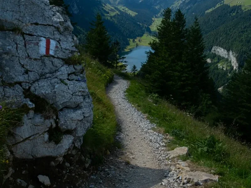
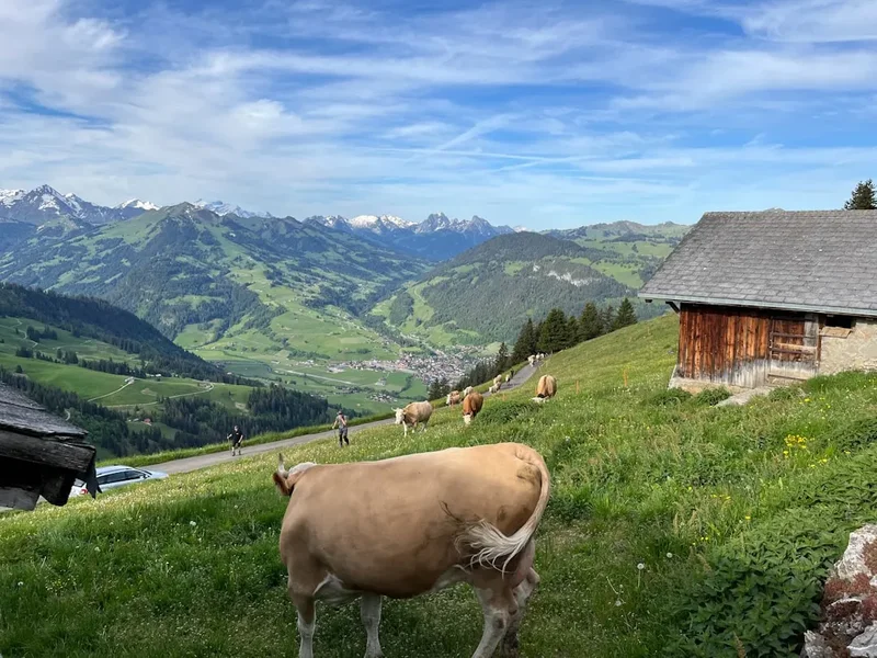
The Greina Plateau, or Greinaplateau in German, is a high-altitude moorland and a significant natural landscape in the Swiss Alps. Situated on the border between the cantons of Graubünden and Ticino, it forms part of the watershed between the Rhine and the Po river systems. The crossing is not a single, clearly defined path but rather a network of trails and routes that allow for exploration of this expansive and relatively flat, yet wild, alpine environment. The terrain is a mosaic of wet meadows, rocky scree, small tarns, and scattered dwarf pine bushes, all set against a backdrop of imposing peaks.
The journey typically begins in the picturesque village of Vrin in the Val Lumnezia (Graubünden) and concludes in Santa Maria in the Val Poschiavo (Graubünden), or vice versa, often involving a connection to the Bernina Pass region. The moderate difficulty rating reflects the distance and the need for good navigation skills, as well as the potential for changeable mountain weather. While the elevation gain is not extreme, the undulating nature of the plateau and the often boggy ground can make for slow progress. The reward is an immersion in a landscape that feels remarkably untouched, a place where the silence is broken only by the wind, the calls of alpine birds, and the gentle murmur of streams.
The Greina Plateau is a vital ecological area, home to a unique flora and fauna adapted to its harsh conditions. Hikers can expect to see a variety of alpine flowers in bloom during the summer months, and if fortunate, may spot marmots, chamois, or even golden eagles. The sense of remoteness is profound, with long stretches of the hike offering no signs of human habitation. This makes careful planning and preparation essential for a safe and enjoyable experience.
History and Cultural Context
The Greina Plateau has a long history of human use, primarily by shepherds and farmers who have grazed their livestock on its rich alpine pastures for centuries. The area's strategic location, straddling important routes between northern and southern Europe, also meant it was traversed by traders and travellers long before the advent of modern infrastructure. The plateau's unique hydrological significance, acting as a watershed for major European river systems, has also made it a subject of scientific interest and conservation efforts.
Historically, the region was part of the Walser settlements, a Germanic people who migrated into the Alps from the 12th century onwards. Their influence can still be seen in the architecture and traditions of villages like Vrin. The development of the Greina Plateau Crossing as a defined hiking route is a more recent phenomenon, driven by the growing interest in alpine trekking and the desire to explore remote, less-commercialised areas. The establishment of mountain huts and bivouac shelters has made the route more accessible, while still preserving its wild character.
In recent decades, there have been significant efforts to protect the ecological integrity of the Greina Plateau. Its status as a high-altitude moorland and its importance as a biodiversity hotspot have led to its designation as a protected area. This conservation focus ensures that the landscape remains largely as it has been for centuries, offering a genuine wilderness experience to those who venture here.
Seasonal Highlights and Weather Reality
The best time to undertake the Greina Plateau Crossing is during the summer months, from July to September. During this period, the snow has typically melted from the higher passes and meadows, making the trails accessible and the terrain traversable. The alpine flora is in full bloom, creating a vibrant and colourful landscape.
July: The early summer month often sees the last of the snow patches melting, and the plateau begins to awaken. Wildflowers start to appear, and the days are long, offering ample daylight for hiking. The weather can still be unpredictable, with a possibility of late snowfalls or thunderstorms.
August: This is generally considered the peak season for the Greina Plateau. The weather is often at its most stable, with warmer temperatures and longer periods of sunshine. The meadows are a riot of colour, and wildlife is abundant. However, August can also see more visitors, though the remoteness of the plateau ensures it never feels crowded.
September: As autumn approaches, the landscape begins to transform. The vibrant greens of summer give way to the golden hues of autumn. The air becomes crisper, and the crowds thin out considerably. While the weather can become more unsettled with a higher chance of rain or early snow, September offers a serene and beautiful experience for those who appreciate the changing seasons.
Weather Considerations: Mountain weather is notoriously fickle. Even during the summer months, hikers must be prepared for rapid changes. Thunderstorms can develop quickly in the afternoons, bringing heavy rain, lightning, and a significant drop in temperature. Snowfall is possible at any time of year at higher elevations. It is crucial to check the weather forecast before setting out and to be prepared for all conditions.
Recommended Itinerary
2-Day Greina Plateau Crossing Itinerary
Day 1: Vrin to Capanna Scaradra (or nearby bivouac)
- Distance: Approximately 12-14 km
- Elevation gain: Approximately 600-700 m
- Time: 4-5 hours
- Start in the charming village of Vrin (1,440 m)
- Follow marked trails ascending through alpine meadows and sparse forests
- The path gradually climbs towards the Greina Plateau
- Pass through areas with scattered boulders and small streams
- Reach the vast, undulating expanse of the Greina Plateau
- Continue across the plateau, enjoying the expansive views and sense of remoteness
- Arrive at Capanna Scaradra (2,170 m), a mountain hut offering basic accommodation and meals (booking recommended)
- Alternatively, there are bivouac shelters or designated wild camping spots in the vicinity for a more rustic experience
- Settle in, enjoy the alpine sunset, and prepare for the next day's journey
Day 2: Capanna Scaradra to Santa Maria (Val Poschiavo)
- Distance: Approximately 10-12 km
- Elevation gain: Approximately 200-300 m (with significant descent)
- Time: 3-4 hours
- Depart from Capanna Scaradra, continuing across the Greina Plateau
- The route may involve traversing boggy sections, so waterproof footwear is essential
- Enjoy the final views of the plateau's unique landscape
- Begin the descent towards Santa Maria
- The trail becomes more defined as it leads into the Val Poschiavo
- Pass through alpine pastures and eventually into more wooded areas
- Arrive in the village of Santa Maria (1,370 m), the end point of the crossing
- From Santa Maria, onward travel options are available, often connecting to the Bernina Pass railway or buses to Poschiavo or Tirano.
3-Day Greina Plateau Crossing Itinerary (for a more relaxed pace or deeper exploration)
Day 1: Vrin to Greina Hut (or bivouac)
- Distance: Approximately 8-10 km
- Elevation gain: Approximately 500-600 m
- Time: 3-4 hours
- A shorter first day allows for a more leisurely start and acclimatisation.
- Arrive at a hut or bivouac shelter closer to the heart of the plateau, allowing for more time to explore the immediate surroundings.
Day 2: Exploration of the Greina Plateau
- Distance: Variable (day hikes from the hut)
- Elevation gain: Variable
- Time: Full day
- Use the second day to explore the vastness of the Greina Plateau.
- Hike to nearby lakes, ascend smaller peaks for panoramic views, or simply wander through the unique moorland landscape.
- This day offers flexibility to tailor the experience to your interests and energy levels.
Day 3: Greina Hut to Santa Maria (Val Poschiavo)
- Distance: Approximately 12-14 km
- Elevation gain: Approximately 200-300 m (with significant descent)
- Time: 4-5 hours
- A longer final day, but still manageable after a day of exploration.
- Descend from the plateau into the Val Poschiavo and reach Santa Maria.
Important Notes:
- The Greina Plateau Crossing is not a single, well-marked trail. Navigation skills and a good map are essential.
- Accommodation options are limited to mountain huts and bivouac shelters. Booking in advance is highly recommended, especially for Capanna Scaradra.
- Wild camping may be permitted in designated areas, but always check local regulations.
- Be prepared for boggy terrain, especially after rain. Waterproof boots and gaiters are advisable.
- Carry sufficient food and water, as services are scarce along the route.
- The weather can change rapidly; always carry appropriate layers and rain gear.
Planning and Bookings
Book Your Trip
Everything you need to plan your journey
Accommodation
Find places to stay near Ilanz
Flights
Search flights to Ilanz
Essential Preparation
The Greina Plateau Crossing is a trek that requires careful planning due to its remote nature and limited infrastructure. Before embarking on this journey, it is crucial to assess your fitness level. While the elevation gain is moderate, the distance and the often boggy terrain can be demanding. Ensure you are comfortable walking for several hours each day with a backpack. Good physical condition is paramount for enjoying the trek safely.
Logistics for reaching the trailhead in Vrin and departing from Santa Maria need to be organised in advance. Vrin is accessible by public transport, typically involving trains to Ilanz and then a bus connection. Santa Maria is also served by public transport, often connecting to the Bernina railway line. Driving is an option, but road access can be challenging, and parking may be limited. It is advisable to research public transport schedules and driving routes well in advance.
The closest major city with an international airport is Zurich (ZRH). From Zurich, you would take a train to Ilanz, which is the main transport hub for the Val Lumnezia region. From Ilanz, local buses will take you to Vrin. For the return journey from Santa Maria, you would typically take a bus to connect with the Bernina Express railway line, which offers scenic travel through the Alps.
Trail Accommodation
Accommodation along the Greina Plateau Crossing is primarily in mountain huts and bivouac shelters. These offer a rustic but essential refuge for hikers.
Capanna Scaradra: This is a well-known mountain hut located on the plateau. It typically offers dormitory-style sleeping arrangements, a communal dining area, and basic facilities. Meals may be available, but it is always wise to confirm this and book in advance, especially during peak season. The hut provides a warm place to sleep and a chance to meet other hikers.
Bivouac Shelters: Scattered across the plateau and surrounding areas are smaller bivouac shelters. These are often more basic than huts, providing just a roof and a few sleeping platforms. They are typically unmanned and offer a more self-sufficient experience. Hikers using bivouac shelters must be entirely self-sufficient for food and cooking.
Wild Camping: In some areas, wild camping may be permitted, but it is essential to check local regulations and practice responsible camping. This usually means camping away from huts and trails, leaving no trace, and being prepared for all weather conditions.
Booking Requirements: For Capanna Scaradra and any other staffed huts, advance booking is strongly recommended, particularly during July and August. Contacting the relevant Alpine Club or hut warden is the best way to secure a spot. Bivouac shelters generally do not require booking but are first-come, first-served.
Facilities Provided: Huts typically provide sleeping platforms or bunks, blankets (though a sleeping bag is usually required), and a communal area for eating and socialising. Some may have basic cooking facilities or offer meals. Bivouac shelters offer minimal shelter.
What's NOT Provided: Hikers must bring all their own food, cooking equipment (if using bivouacs or self-catering), sleeping bags, toiletries, and personal items. There are no charging facilities, electricity, or running water in most bivouac shelters.
Seasonal Availability: Huts and bivouac shelters are generally open from June/July to September/October, depending on snow conditions. Outside these months, they may be closed or inaccessible due to snow.
Costs: Hut fees vary but typically range from CHF 30-60 per night for a dorm bed, with potential extra charges for meals. Bivouac shelters are usually free or have a nominal fee.
Required Gear
- Sturdy Hiking Boots: Waterproof, broken-in hiking boots with good ankle support are essential. The terrain can be uneven and boggy.
- Waterproof Jacket and Trousers: High-quality, breathable waterproofs are non-negotiable. Mountain weather can change rapidly, and you must be prepared for rain and wind.
- Warm Layers: A fleece jacket or insulated jacket, thermal base layers (merino wool or synthetic), and a warm hat and gloves are necessary, even in summer, due to altitude and potential for cold weather.
- Backpack: A comfortable backpack of 40-60 litres capacity, with a rain cover, is needed to carry your gear.
- Navigation Tools: A detailed topographic map of the region, a compass, and a GPS device or smartphone with offline maps are crucial. The trails can be indistinct in places.
- Head Torch: With spare batteries, for use in huts, bivouacs, or in case of unexpected delays.
- First-Aid Kit: Comprehensive kit including blister treatment, pain relievers, bandages, antiseptic wipes, and any personal medications.
- Sun Protection: High SPF sunscreen, sunglasses, and a wide-brimmed hat are important, as the sun's intensity is high at altitude.
- Trekking Poles: Highly recommended for stability on uneven terrain and to reduce strain on knees during descents.
What to Bring
- Food: Sufficient non-perishable food for the duration of your trek, including breakfast, lunch, dinner, and snacks. Consider lightweight, high-energy options.
- Water Bottles/Hydration Reservoir: Carry at least 2 litres of water capacity per person.
- Water Treatment: A water filter or purification tablets are recommended, as stream water, while plentiful, should be treated.
- Cooking Equipment: If using bivouac shelters or self-catering in huts, bring a lightweight stove, fuel, pot, utensils, and a lighter or waterproof matches.
- Sleeping Bag: A warm sleeping bag (rated to at least 0°C comfort) is essential for huts and bivouacs.
- Toiletries: Biodegradable soap, toothbrush, toothpaste, toilet paper, and hand sanitiser.
- Personal Items: Camera, power bank for electronics, book or journal, insect repellent (especially for midges/mosquitoes in boggy areas).
- Cash: Some huts may not accept credit cards, so carry sufficient Swiss Francs (CHF) for accommodation, food, and any potential transport.
- Trash Bags: To pack out all your waste.
Permits
For the Greina Plateau Crossing itself, no specific permits are generally required for hiking. The trails are part of the public domain and accessible to all. However, it is crucial to be aware of local regulations regarding camping and the use of mountain huts.
Mountain Hut Usage: While booking is not always mandatory for bivouac shelters, it is highly recommended for staffed huts like Capanna Scaradra, especially during the peak summer months (July and August). Contacting the hut warden or the relevant Alpine Club (e.g., SAC - Swiss Alpine Club) in advance is the best way to secure a place and confirm their operating status and any specific rules.
Wild Camping: Regulations regarding wild camping can vary by canton and municipality. In general, wild camping is discouraged or prohibited in protected areas, near huts, and in areas with high visitor traffic. If permitted, it is expected to be done responsibly, leaving no trace, and typically for a single night only. Always check local signage and regulations before setting up camp.
National Park Regulations: While the Greina Plateau is not within a strictly enforced national park like some other Alpine regions, it is a sensitive ecological area. Hikers are expected to adhere to principles of responsible outdoor recreation, including staying on marked paths where they exist, minimising disturbance to wildlife, and packing out all waste.
Transport: For access to Vrin and departure from Santa Maria, standard public transport tickets are required. These can be purchased at train stations or online through the SBB (Swiss Federal Railways) website.
Other Activities in the Area
The region surrounding the Greina Plateau offers a wealth of activities for those looking to extend their stay or explore beyond the main trek:
- Exploring Vrin: This picturesque village is renowned for its well-preserved traditional architecture and its status as one of Switzerland's most beautiful villages. Take time to wander its streets and admire the Walser houses.
- Hiking in Val Lumnezia: The valley leading to Vrin offers numerous other hiking trails, ranging from gentle valley walks to more challenging mountain ascents.
- Bernina Railway: The Bernina Pass region, accessible from Santa Maria, is famous for the UNESCO World Heritage Bernina Railway. This scenic train journey offers spectacular views of glaciers, mountains, and lakes.
- Val Poschiavo Exploration: The valley leading from Santa Maria is rich in culture and natural beauty. Explore the town of Poschiavo, visit local museums, and enjoy the regional cuisine.
- Lake Poschiavo: A beautiful alpine lake offering opportunities for leisurely walks along its shores or simply enjoying the scenery.
- Climbing and Mountaineering: For experienced climbers, the surrounding peaks offer challenging routes. Local guides can be hired for guided ascents.
- Cycling: The valleys and lower mountain roads are popular with cyclists, offering routes with varying degrees of difficulty.
Safety and Conditions
Weather: The most significant safety consideration on the Greina Plateau is the unpredictable mountain weather. Thunderstorms can develop rapidly in the afternoons, bringing heavy rain, lightning, and a sharp drop in temperature. Snowfall is possible even in summer at higher elevations. Always check the weather forecast before setting out and be prepared to alter your plans if conditions deteriorate.
Navigation: The Greina Plateau is a vast, open area with often indistinct trails. Good navigation skills are essential. Carry a detailed topographic map, a compass, and a GPS device or smartphone with offline maps. Familiarise yourself with the route before you start and be prepared to navigate by bearings if visibility is poor.
Terrain: Large sections of the Greina Plateau are high-altitude moorland, which can be very boggy and wet, especially after rain. Waterproof hiking boots and gaiters are highly recommended to keep your feet dry and comfortable. Uneven ground and rocky sections also require careful footing.
Remoteness: The Greina Plateau is a remote area with limited facilities and infrequent human contact. Ensure you are self-sufficient in terms of food, water, and emergency supplies. Mobile phone reception can be patchy or non-existent in many areas.
Emergency Procedures: Know how to contact emergency services in Switzerland. The general emergency number is 144 for ambulance, 117 for police, and 118 for fire. For mountain rescue, the number is 1414 (REGA - Swiss Air Rescue). Inform someone of your itinerary and expected return time.
Altitude: While not extremely high, the plateau is at an altitude of over 2,000 metres. Be aware of the symptoms of altitude sickness, especially if you are not acclimatised. Ascend gradually and stay hydrated.
Wildlife: While generally not dangerous, be aware of local wildlife. Marmots are common, and you may encounter chamois. Respect their space and do not attempt to feed them.
Insurance: Ensure you have adequate travel insurance that covers hiking and potential mountain rescue.
Side Trips and Points of Interest
Capanna Scaradra Vicinity: The area around Capanna Scaradra itself is a prime location for exploration. The hut serves as an excellent base for short hikes to discover hidden tarns, ascend minor peaks for panoramic views of the plateau, or simply to absorb the unique atmosphere of this high-alpine moorland.
Piz Terri: For experienced mountaineers, Piz Terri (3,020 m) is a prominent peak accessible from the Greina Plateau. Ascending Piz Terri offers a challenging climb and rewards with commanding views over the surrounding mountain ranges, including the Bernina massif.
Lakes of the Greina: Scattered across the plateau are numerous small alpine lakes (tarns). These offer beautiful photographic opportunities and peaceful spots for a rest. Some of the larger ones might be named on detailed maps.
Walser Villages: The villages of Vrin and Santa Maria, at either end of the crossing, are points of interest in themselves. Vrin, in particular, is celebrated for its well-preserved Walser architecture and its commitment to sustainable tourism. Exploring these villages provides cultural context to the journey.
Hydrological Significance: The Greina Plateau is a crucial watershed. Understanding its role in dividing the waters of the Rhine and the Po adds an interesting dimension to the hike. Look for streams and rivulets and consider where their waters will eventually flow.
Leave No Trace
The Greina Plateau is a fragile alpine ecosystem, and it is essential for all visitors to practice Leave No Trace principles to preserve its natural beauty and ecological integrity for future generations. The remoteness and the slow regeneration of alpine vegetation mean that human impact can be long-lasting.
Plan Ahead and Prepare: Research the area, understand local regulations, and be prepared for all weather conditions. Carry appropriate gear and sufficient food and water to minimise reliance on the environment.
Travel and Camp on Durable Surfaces: Stick to established trails where they exist. If camping, choose established sites or durable surfaces like rock or gravel, well away from water sources and vegetation. Avoid trampling fragile alpine meadows.
Dispose of Waste Properly: Pack out everything you pack in, including all food scraps, wrappers, and any other litter. Use designated toilet facilities where available. If not, dig a cathole at least 60 metres away from water, trails, and campsites, and bury human waste and toilet paper.
Leave What You Find: Do not remove or disturb natural objects such as rocks, plants, or flowers. Take only photographs and memories.
Minimise Campfire Impacts: Campfires are generally not permitted in alpine areas due to the risk of wildfire and damage to vegetation. Use a lightweight stove for cooking.
Respect Wildlife: Observe wildlife from a distance. Do not feed animals, as this can disrupt their natural behaviours and diets. Store food securely to prevent attracting animals.
Be Considerate of Other Visitors: Keep noise levels down, especially in huts and bivouacs. Yield to other hikers on narrow trails. Respect the solitude and natural quiet of the wilderness.