Great Himalaya Trail - The Ultimate High Altitude Odyssey
The Great Himalaya Trail (GHT) is not merely a trek; it is the definitive mountain journey of the modern era. Stretching approximately 1,700 kilometres across the entire length of the Nepalese Himalaya, it represents the longest and highest alpine hiking track in the world. This is a traverse of an entire nation, beginning in the shadow of Kanchenjunga on the eastern border with India and concluding at the Tibetan border in the far west of Humla. The GHT is a monumental undertaking that crosses 16 districts, traverses two of the world's most restricted mountain regions, and navigates over some of the highest navigable passes on Earth, many exceeding 6,000 metres in elevation. It is a journey that demands months of commitment, exceptional physical fortitude, and a deep respect for the volatile nature of the high-altitude environment.
- Distance: 1,700 km (High Route)
- Duration: 120–150 days
- Total Elevation Gain: Approximately 120,000 m
- Highest Point: West Col (6,143 m) or Sherpani Col (6,135 m)
- Difficulty: Very Challenging / Expedition Level
- Best Time: March–May (Pre-monsoon) and October–November (Post-monsoon)
- Accommodation: Mix of tea houses, basic homestays, and remote wilderness camping
- Permits: Multiple National Park, Conservation Area, and Restricted Area Permits required
Overview
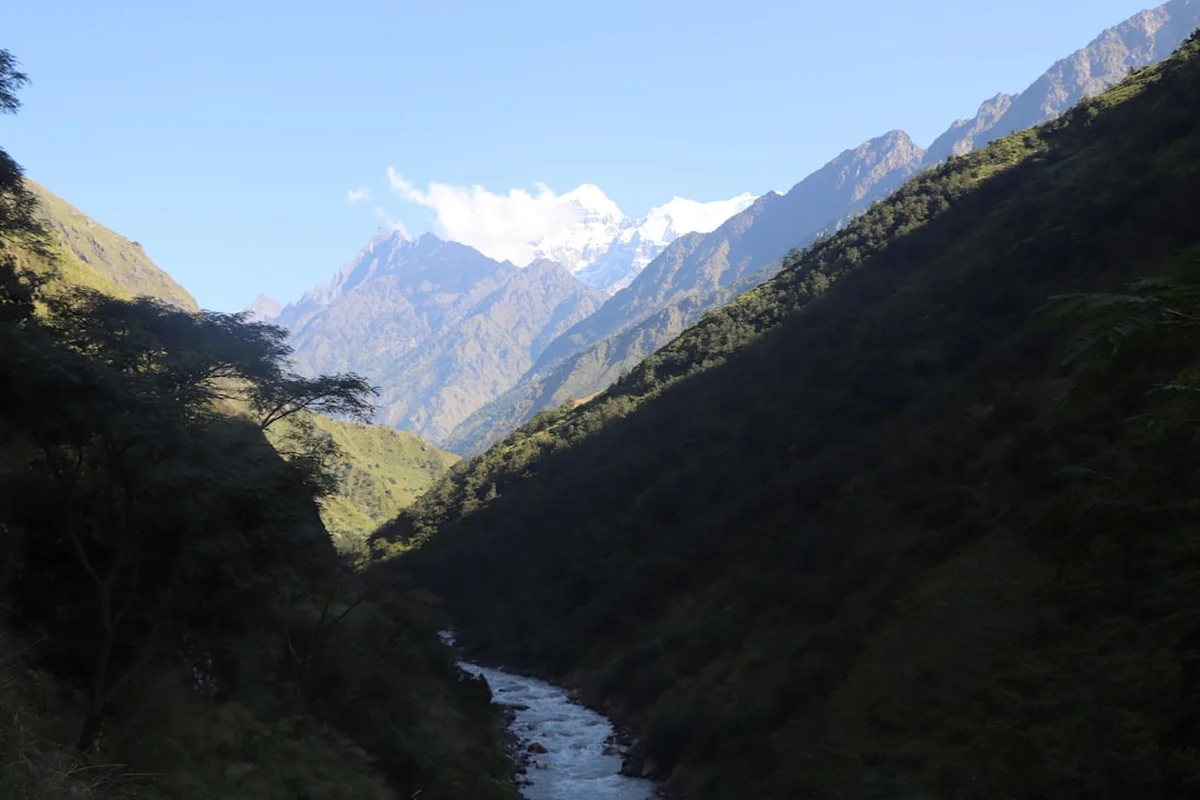
The Great Himalaya Trail is the "Holy Grail" of thru-hiking. While the Appalachian Trail or the Pacific Crest Trail offer forest immersion and continental scale, the GHT offers verticality and cultural depth that is entirely unique. The trail is generally divided into two main options: the "High Route" and the "Cultural Route" (or Low Route). The High Route, which this guide focuses on, stays as close to the Great Himalaya Range as possible, frequently crossing high-altitude passes that require basic mountaineering skills, ice axes, and crampons. It is a route of extremes, where you transition from tropical jungles at 600 metres to glacial plateaus above 6,000 metres within the span of a few weeks.
Walking the GHT is a lesson in the diversity of the human experience. In the east, you traverse the lush, rhododendron-filled forests of the Kanchenjunga and Makalu regions, where the Rai and Limbu cultures predominate. As you move west into the Khumbu (Everest) and Rolwaling regions, the landscape becomes dominated by granite and ice, and the Sherpa culture takes centre stage. Further west still, the trail enters the arid, Tibetan-influenced landscapes of Mustang and Dolpo, where ancient Bon and Buddhist traditions have remained largely unchanged for centuries. Finally, the trail concludes in the remote, rugged canyons of the Far West, a region so isolated that few Westerners have ever set foot there.
The physical toll of the GHT cannot be overstated. With a cumulative elevation gain of 120,000 metres—the equivalent of climbing Mount Everest from sea level nearly 14 times—the trail tests the limits of human endurance. The logistics are equally daunting, requiring a complex web of permits, food drops, and seasonal timing to avoid the heavy snows of winter and the torrential rains of the summer monsoon. However, for those who complete it, the reward is an unparalleled perspective on the roof of the world and a profound connection to the resilient communities that call these mountains home.
History and Cultural Context
The concept of a continuous trail across the Himalaya is a relatively modern one, though the paths themselves are ancient. For millennia, these routes served as vital trade arteries connecting the Indian subcontinent with the Tibetan Plateau. Salt, grain, wool, and spices were transported by yak caravans and human porters across the very passes that GHT hikers navigate today. These trails were never intended for recreation; they were the lifelines of mountain survival.
The formalisation of the Great Himalaya Trail began in the early 21st century. Robin Boustead, a British explorer and trekker, is widely credited with mapping and documenting the first continuous high-level route across Nepal between 2008 and 2009. His work, supported by the Nepal Tourism Board and various international development agencies, aimed to create a sustainable tourism model that would bring economic benefits to remote mountain communities beyond the traditional hubs of Everest and Annapurna. The GHT was officially launched in 2011, envisioned as a network of trails spanning not just Nepal, but the entire Himalayan range from Bhutan to Pakistan.
Culturally, the GHT is a tapestry of ethnic diversity. Nepal is home to over 125 ethnic groups, and the trail passes through the heartlands of many. From the Kirat people in the east to the Thakali in the Kali Gandaki Valley and the Khas people in the west, the trail provides a front-row seat to the linguistic, religious, and social complexity of the region. The trail also highlights the fragile balance between tradition and modernity, as remote villages grapple with the arrival of road networks and the impacts of climate change on their glacial water sources.
Want more background? Read extended notes on history and cultural context → Learn more
Seasonal Highlights and Weather Reality
Timing is the most critical factor in a successful GHT thru-hike. Because the trail takes 4 to 5 months to complete, it is impossible to avoid all "bad" weather, but strategic planning can minimise risk. Most hikers choose to start in the spring (March) or autumn (September/October).
Spring (March to May): This is the preferred season for many because of the spectacular flora. The lower hills are ablaze with blooming rhododendrons (Nepal's national flower), and the days are progressively getting longer and warmer. However, spring can bring significant residual snow on the high passes from the winter, sometimes making them impassable until late April. Haze can also obscure distant mountain views in the lower valleys during the pre-monsoon heat.
Autumn (September to November): This is the "golden season" for Himalayan trekking. After the monsoon rains have washed the dust from the air, the visibility is crystalline, offering the most iconic views of the 8,000-metre peaks. The weather is generally more stable, though temperatures drop significantly as November approaches. The main challenge for GHT hikers in autumn is the race against the winter snows; if you are still in the high-altitude regions of Dolpo or Humla in December, you risk being trapped by heavy snowfall.
Monsoon (June to August): Thru-hiking during the monsoon is generally discouraged. The trails become slippery, leeches are rampant in the forests, and clouds obscure the mountains. More importantly, the risk of landslides and floods increases dramatically. However, certain sections of the GHT, such as Upper Mustang and Upper Dolpo, lie in the rain shadow of the Himalaya and remain dry and accessible during the monsoon months.
Winter (December to February): The high passes of the GHT are closed by deep snow, and temperatures at altitude can drop to -30°C. Only the "Low Route" is feasible during this time, and even then, many high-altitude villages are abandoned as residents migrate to lower elevations for the winter.
Recommended Itinerary
The 10 Stages of the Great Himalaya Trail (High Route)
Stage 1: Kanchenjunga Region (East Nepal)
- Distance: 160 km
- Duration: 15–18 days
- Key Waypoints: Taplejung, Kanchenjunga Base Camp (Pangpema), Lumba Sumba Pass (5,160 m)
- Highlights: Views of the world's third-highest peak, remote Limbu villages, and the transition into the Makalu Barun National Park
- Terrain: Steep river valleys followed by high alpine meadows and glacial moraine
Stage 2: Makalu Barun
- Distance: 140 km
- Duration: 12–15 days
- Key Waypoints: Makalu Base Camp, Sherpani Col (6,135 m), West Col (6,143 m), Amphu Labsta Pass (5,845 m)
- Highlights: The "Great Three Passes"—the most technical and difficult section of the entire GHT
- Terrain: High-altitude glacier crossings requiring ropes, ice axes, and mountaineering proficiency
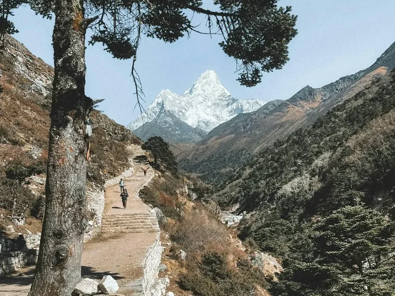
Stage 3: Everest and Rolwaling
- Distance: 180 km
- Duration: 18–22 days
- Key Waypoints: Chhukung, Cho La Pass (5,420 m), Renjo La Pass (5,360 m), Tashi Labsta Pass (5,755 m), Beding
- Highlights: Iconic views of Everest, Lhotse, and Ama Dablam; the rugged and sacred Rolwaling Valley
- Terrain: Well-maintained trails in the Khumbu, followed by extremely remote and technical terrain in Rolwaling
Stage 4: Langtang and Helambu
- Distance: 130 km
- Duration: 10–12 days
- Key Waypoints: Tilman’s Pass (5,308 m), Langshisha Kharka, Kyanjin Gompa, Syabru Besi
- Highlights: The beautiful Langtang Valley and the challenging crossing of Tilman’s Pass
- Terrain: High alpine passes and lush larch forests
Stage 5: Ganesh Himal and Manaslu
- Distance: 150 km
- Duration: 14–16 days
- Key Waypoints: Gatlang, Larkya La Pass (5,106 m), Samagaon
- Highlights: Circumnavigating Manaslu (8,163 m) and experiencing the Tibetan-influenced culture of the Tsum Valley
- Terrain: Long ascents through varied climatic zones, from subtropical to alpine
Stage 6: Annapurna and Mustang
- Distance: 200 km
- Duration: 18–20 days
- Key Waypoints: Thorong La Pass (5,416 m), Kagbeni, Lo Manthang, Teri La Pass (5,590 m)
- Highlights: The medieval walled city of Lo Manthang and the arid, "desert" landscapes of the rain shadow
- Terrain: High-altitude desert plateaus and ancient trade routes
Stage 7: Dolpo
- Distance: 220 km
- Duration: 20–25 days
- Key Waypoints: Chharka Bhot, Phoksundo Lake, Kang La Pass (5,350 m), Shey Gompa
- Highlights: The deep blue waters of Phoksundo Lake and the ancient Bon monasteries of Shey Gompa
- Terrain: Some of the most remote and rugged trekking in Nepal; long distances between settlements
Stage 8: Mugu
- Distance: 120 km
- Duration: 10–12 days
- Key Waypoints: Gamgadhi, Rara Lake
- Highlights: Rara Lake, the largest lake in Nepal, surrounded by pine forests and snow-capped peaks
- Terrain: Gentler terrain compared to Dolpo, but still very remote
Stage 9: Humla
- Distance: 140 km
- Duration: 12–14 days
- Key Waypoints: Simikot, Nara La Pass (4,560 m), Hilsa (Tibetan border)
- Highlights: The ancient salt trade route to Tibet and the unique culture of the Humli people
- Terrain: Deep river canyons and high, dry ridges
Stage 10: Far West (The Final Frontier)
- Distance: 160 km
- Duration: 14–16 days
- Key Waypoints: Yari, Urai Lagna Pass (5,207 m), Chainpur
- Highlights: Reaching the westernmost point of the trail and completing the traverse
- Terrain: Extremely wild and unmapped sections where trail-finding skills are essential
Planning and Bookings
Book Your Trip
Everything you need to plan your journey
Accommodation
Find places to stay near Kathmandu
Flights
Search flights to Kathmandu
Essential Preparation
Planning a GHT thru-hike is a full-time job that should begin at least a year in advance. The primary challenge is logistics: coordinating permits for different regions, arranging food drops in areas without shops, and hiring a qualified support team for the technical sections. Most hikers base themselves in Kathmandu for at least two weeks prior to departure to finalise paperwork and purchase supplies.
Physical preparation must be rigorous. You should be comfortable walking 15–25 kilometres a day with a significant pack weight for months on end. Training should include high-altitude experience and basic mountaineering skills (self-arrest with an ice axe, glacier travel, and fixed-line ascending). Mental resilience is equally important; the GHT involves long periods of isolation, physical discomfort, and the constant need to adapt to changing conditions.
Trail Accommodation
Accommodation on the GHT varies wildly depending on the region. In popular areas like Everest and Annapurna, you will stay in well-equipped tea houses with menus, hot showers, and even WiFi. However, for approximately 60% of the High Route, you will be self-sufficient.
Types of Accommodation:
- Tea Houses: Found in Khumbu, Langtang, Manaslu, and Annapurna. Provide a bed, blankets, and hot meals. Costs range from 500 to 2,000 NPR per night.
- Homestays: In less-developed regions like Kanchenjunga or parts of the Far West, you may stay in a local family's home. Facilities are basic (sleeping on a floor mat), and you eat what the family eats (usually Dal Bhat).
- Wilderness Camping: Mandatory for the high passes (Sherpani Col, Tilman’s Pass, etc.) and throughout much of Dolpo and Mugu. You must carry your own tent, stove, and fuel.
- Shelters: Very rare; occasionally basic stone huts used by herders (Goths) may be available, but they are often flea-ridden and smoky.
Required Gear
- Footwear: High-quality, waterproof mountaineering boots (B2 or B3 rated) for the high passes, plus a pair of lightweight trekking shoes or sandals for camp and lower elevations.
- Technical Gear: Ice axe, crampons, climbing harness, 2–3 carabiners, and a descender (ATC or Figure-8). A 30-metre alpine rope is essential for the group.
- Sleep System: A 4-season sleeping bag (comfort rating -20°C) and a high-R-value insulated sleeping mat.
- Pack: A 65–75 litre internal frame pack with a waterproof cover.
- Clothing: Layering is key. Merino wool base layers, a heavy down jacket (800+ fill), waterproof hardshell jacket and trousers, and various mid-layers (fleece or Primaloft).
- Navigation: GPS with pre-loaded GHT tracks, paper maps (Himalayan Map House series), and a reliable compass.
What to Bring
- Food: While Dal Bhat is available in villages, you must carry lightweight, high-calorie expedition food (dehydrated meals, nuts, energy bars) for the 10–14 day stretches between settlements.
- Water Treatment: A combination of a high-flow filter (like a Katadyn) and chemical treatment (Chlorine dioxide) for backup. Never drink untreated water.
- Fuel: Multi-fuel stoves are preferred as white gas or kerosene is easier to find in remote areas than canister gas (though canisters are available in Kathmandu and Namche).
- Medical Kit: Comprehensive kit including antibiotics, Diamox (for altitude), strong pain relief, wound care, and a dental repair kit.
- Power: A large capacity power bank (20,000mAh+) and a portable solar panel (20W+) to charge devices in remote areas.
Permits

The permit requirements for the GHT are the most complex of any trail in the world. Because you cross multiple protected areas and border zones, you cannot simply buy one "GHT Permit." You must acquire them sequentially or all at once in Kathmandu.
Mandatory Permits Include:
- TIMS Card: The Trekkers' Information Management System card is required for most regions.
- National Park & Conservation Area Permits: Including Kanchenjunga, Makalu Barun, Sagarmatha (Everest), Gaurishankar, Langtang, Manaslu, Annapurna, and Shey Phoksundo. Costs are typically 3,000 NPR per park.
- Restricted Area Permits (RAP): These are the most expensive and difficult to obtain. They are required for Upper Mustang, Upper Dolpo, Manaslu, Tsum Valley, and parts of Humla. RAPs often cost US$500 for the first 10 days and require a minimum of two trekkers and a licensed Nepali guide.
Important Note: Regulations in Nepal change frequently. It is highly recommended to use a reputable trekking agency in Kathmandu to process these permits. Attempting to do it yourself can result in weeks of bureaucratic delays.
Other Activities in the Area
Given that the GHT starts and ends in Kathmandu, and passes through Nepal's most famous regions, there are numerous ways to augment the journey:
- Peak Climbing: Many GHT hikers combine the trek with "Trekking Peaks" such as Island Peak (6,189 m) or Mera Peak (6,476 m) to gain even better views.
- Kathmandu Cultural Tours: Spend time at the UNESCO World Heritage sites of Pashupatinath, Boudhanath, and Swayambhunath before or after the trek.
- Yoga and Meditation Retreats: Many hikers find a week-long retreat in the Kathmandu Valley or Pokhara is the perfect way to recover from the physical strain of the trail.
- Chitwan National Park: For a complete change of scenery, head to the southern Terai for a jungle safari to see rhinos, crocodiles, and tigers.
- Mountain Biking: The Lower Route of the GHT is increasingly popular with mountain bikers looking for a rugged, multi-month challenge.
Safety and Conditions
The Great Himalaya Trail is a high-risk environment. The combination of extreme altitude, remote geography, and unpredictable weather means that help is often days or weeks away. You must be self-reliant.
Altitude Sickness (AMS, HAPE, and HACE): This is the primary killer on the GHT. You will spend months above 4,000 metres. It is vital to follow acclimatisation protocols: never ascend more than 300–500 metres of sleeping altitude per day once above 3,000 metres, and take a rest day every 1,000 metres of gain. Carry Diamox and know how to recognise the symptoms of pulmonary and cerebral oedema.
Weather Extremes: Blizzards can occur at any time of year on the high passes. Whiteout conditions make navigation impossible without a GPS. Conversely, the sun at high altitude is incredibly intense; snow blindness and severe sunburn are constant threats.
Remote Rescue: Helicopter evacuation is available in Nepal but is extremely expensive (US$5,000–$10,000). You must have specialised travel insurance that covers search and rescue up to 6,000 metres. Carry a satellite communication device (Garmin inReach or Zoleo) as mobile signal is non-existent for 80% of the trail.
Water and Hygiene: Gastrointestinal issues are common. Practise strict hygiene: wash hands frequently and treat all water. A single bout of severe dysentery can end a thru-hike attempt.
Side Trips and Points of Interest
The GHT is a "spine" from which many incredible side trips branch off. If you have the time and energy, these are highly recommended:
Everest Base Camp (EBC) and Kala Patthar: While the GHT passes through the Khumbu, a 2-day detour to EBC allows you to stand at the foot of the world's highest peak. The view from Kala Patthar (5,545 m) at sunset is arguably the finest mountain panorama on Earth.
The Tsum Valley: Branching off from the Manaslu Circuit, this "Hidden Valley" is a sanctuary of ancient Tibetan culture where the practice of non-violence (Shagya) is strictly observed. It adds about 6–8 days to the itinerary but offers a profound spiritual experience.
Tilicho Lake: Located near the Annapurna Circuit, this is one of the highest lakes in the world (4,919 m). The GHT High Route can be modified to pass by its turquoise waters, though the "Mesokanto La" pass required to exit the lake area is notoriously difficult and prone to rockfall.
Shey Gompa and the Crystal Mountain: In Upper Dolpo, this 11th-century monastery is the spiritual heart of the region. Every year, pilgrims circumambulate the Crystal Mountain, a peak rich in marine fossils that proves the Himalaya were once at the bottom of the sea.
Leave No Trace

The Himalayan environment is one of the most fragile on the planet. The "Pack it in, pack it out" philosophy is mandatory. In remote areas of the GHT, there is no waste management infrastructure; anything you leave behind will remain there for decades.
- Waste Management: Carry out all plastic, foil, and tins. For human waste, use toilets where available. In the wilderness, dig a "cathole" at least 20 centimetres deep and 100 metres from any water source. Burn or pack out your toilet paper.
- Fuel Use: Never use wood for cooking or heating. Deforestation is a critical issue in the Himalaya. Use only kerosene, white gas, or canister gas.
- Respect Wildlife: The GHT passes through habitats of the Snow Leopard, Red Panda, and Himalayan Blue Sheep. Observe from a distance and never feed animals.
- Cultural Respect: Always walk to the left of mani walls, chortens, and stupas (clockwise). Ask permission before taking photos of people or religious ceremonies.