Great Divide Trail - Canada's Ultimate Wilderness Thru-Hike
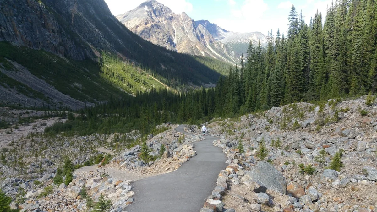
The Great Divide Trail (GDT) is not merely a hike; it is a profound immersion into the raw, unyielding heart of the Canadian Rockies. Stretching approximately 1,130 kilometres from the United States border in Waterton Lakes National Park to the remote wilderness of Kakwa Provincial Park, the GDT follows the continental divide—the hydrological spine of North America. Unlike the highly manicured and heavily trafficked National Scenic Trails in the United States, the GDT is a rugged, often primitive route that demands exceptional navigation skills, physical resilience, and a deep respect for the mountain environment. It traverses five National Parks (Waterton Lakes, Banff, Kootenay, Yoho, and Jasper), eight Provincial Parks, and vast tracts of public wilderness land, offering a diversity of landscapes that range from high alpine meadows and glacial basins to dense, valley-bottom forests and windswept ridges.
Walking the GDT is a journey through some of the most spectacular and protected landscapes on Earth. However, the "trail" itself is often a conceptual link between existing hiking paths, decommissioned forestry roads, and challenging cross-country sections where no physical tread exists. This is a thru-hike for those who seek solitude and a genuine wilderness experience. It is a route where grizzly bear encounters are a reality, where river crossings can be waist-deep and icy, and where the weather can shift from summer heat to a blinding snowstorm in a matter of hours. For the prepared adventurer, the reward is an unparalleled connection to the wild, a sense of accomplishment that comes from navigating one of the world's most challenging long-distance routes, and a front-row seat to the geological majesty of the Great Divide.
- Distance: 1,130 km one-way
- Duration: 7 to 10 weeks (2-3 months)
- Season: Late July to mid-September (snow-free window is narrow)
- Elevation Gain: Approximately 57,715 metres
- Highest Point: Approximately 2,590 metres (near Mount Assiniboine)
- Difficulty: Very Challenging (requires advanced navigation and wilderness skills)
- Direction: Typically hiked South to North (NOBO) to follow the melting snow
Overview
The Great Divide Trail is frequently described as the "wilder, more rugged cousin" of the Continental Divide Trail (CDT) in the United States. While it shares the same geological spine, the GDT is distinct in its lack of formal recognition and infrastructure. It is not an officially designated National Trail in the same way as the Appalachian or Pacific Crest Trails; instead, it is a route maintained and advocated for by the Great Divide Trail Association (GDTA), a dedicated group of volunteers. This lack of official status is precisely what preserves its character. On the GDT, you are more likely to follow a faint elk path or a compass bearing than a well-marked gravel track. The route is divided into seven distinct sections (A through G), each offering a unique set of challenges and aesthetic rewards.
The journey begins in the south at the International Boundary in Waterton Lakes National Park, where the mountains rise abruptly from the prairies. From here, the trail moves north through the High Rockies, crossing the continental divide dozens of times. Walkers will experience the limestone peaks of the Kananaskis region, the iconic turquoise lakes of Banff and Yoho, and the massive icefields of Jasper. The final sections, F and G, are legendary for their remoteness, taking hikers into the "Northern Rockies" where resupply points vanish, and the wilderness becomes truly absolute. Here, the trail ends at Kakwa Lake, a location so remote that hikers must then walk an additional 30 to 75 kilometres just to reach the nearest road access.
Logistically, the GDT is a masterpiece of planning. Because it passes through multiple National and Provincial Parks, hikers must navigate a complex web of permit systems, often booking campsites months in advance. Resupply is another major hurdle, with some stretches requiring hikers to carry 10 to 12 days of food or arrange for remote caches. The physical toll is equally significant; the trail involves constant elevation changes, with daily gains and losses often exceeding 1,000 metres. However, for those who persevere, the GDT offers something increasingly rare in the modern world: a chance to disappear into a landscape that feels as though it has remained unchanged for millennia. It is a test of character, a celebration of the Canadian wilderness, and arguably the finest long-distance hiking experience in North America.
History and Cultural Context
The history of the Great Divide Trail is a story of grassroots passion and persistence. The concept of a trail following the Canadian Rockies' divide was first proposed in 1966 by the Girl Guides of Canada. In 1970, a formal proposal was submitted by Jim Thorsell, which eventually led to the formation of the Great Divide Trail Association in 1975. However, the project faced significant bureaucratic hurdles. Unlike the United States, which passed the National Trails System Act in 1968, Canada lacked a federal framework for long-distance trails. Consequently, the GDT languished for decades, with various sections being built or maintained by small groups of volunteers while other parts remained nothing more than lines on a map.
The trail saw a resurgence in the early 2000s as interest in thru-hiking grew globally. The GDTA was revitalised, and a new generation of hikers began documenting the route, creating GPS tracks, and working with land managers to secure access. Today, the GDT is more popular than ever, yet it remains a volunteer-led project. The trail's existence depends on the tireless work of those who clear deadfall, build bridges, and advocate for the protection of the corridor. It is a "living" trail, constantly evolving as new sections are scouted to move the route off old roads and onto more scenic, sustainable single-track paths.
Culturally, the GDT traverses the traditional territories of many Indigenous peoples, including the Blackfoot (Siksikaitsitapi), Ktunaxa, Stoney Nakoda, Cree, Lheidli T'enneh, and Secwépemc. For thousands of years, these mountains were not "wilderness" to be conquered, but ancestral lands used for hunting, gathering, and spiritual practice. Many of the passes used by the GDT today were originally Indigenous trade routes. Recognising this history is a vital part of the GDT experience. The trail is not just a physical path; it is a journey through a landscape with deep human roots that predate European exploration by millennia. As hikers travel through these valleys, they are walking in the footsteps of generations who have lived in harmony with the Great Divide.
Want more background? Read extended notes on history and cultural context → Learn more
Seasonal Highlights and Weather Reality
The window for hiking the Great Divide Trail is notoriously short. Due to the high elevation and northern latitude, snow remains on the high passes well into July, and the first autumn blizzards can arrive by mid-September. For most thru-hikers, a late June or early July start from the southern terminus is standard, though this often involves significant snow travel in the first two weeks. The "prime" season—when the trails are mostly clear of snow and the alpine wildflowers are in full bloom—is typically from late July to late August.
Summer (July and August): This is the peak of the hiking season. Days are long, with daylight lasting until 10:00 PM in July. Temperatures in the valleys can reach 25°C to 30°C, but alpine temperatures remain cool. This is also the season of the "afternoon thunderstorm." Hikers should aim to be off high ridges and passes by mid-afternoon to avoid lightning. Mosquitoes and blackflies are at their most aggressive in July, particularly in the boggy sections of the northern parks. By August, the bugs subside, but the risk of wildfire smoke increases, which can obscure views and impact air quality.
Autumn (September): September is arguably the most beautiful month on the GDT. The larch trees turn a brilliant gold, the air is crisp and clear, and the bugs are gone. However, it is a month of high risk. Temperatures frequently drop below freezing at night, and major snowstorms are common. Most thru-hikers aim to finish by mid-September to avoid being trapped by deep snow in the remote northern sections (Sections F and G), where rescue is extremely difficult.
Winter and Spring (October to June): The GDT is not a hiking trail during these months; it is an extreme winter environment. The route is buried under several metres of snow, and avalanche risk is extreme across almost the entire length of the trail. Only those with advanced winter mountaineering and avalanche rescue training should consider any portion of the trail during this time.
Recommended Itinerary
The 7 Sections of the Great Divide Trail
Section A: Waterton to Coleman
- Distance: 150 km
- Elevation Gain: 6,200 m
- Time: 6–8 days
- Starts at the US border (International Boundary) in Waterton Lakes National Park
- Highlights: Akamina Ridge, Sage Pass, and the High Rock Trail
- Key Waypoints: Waterton Townsite, Lone Lake, La Coulotte Peak (notorious for its steepness)
- This section introduces hikers to the "GDT style"—steep climbs and rugged ridges
- Resupply: Coleman/Blairmore (Crowsnest Pass)
Section B: Coleman to Kananaskis (Peter Lougheed Provincial Park)
- Distance: 200 km
- Elevation Gain: 8,500 m
- Time: 8–10 days
- Traverses the High Rockies and the Beehive Natural Area
- Highlights: Fording River Pass, Tornado Pass, and the spectacular Highwood Pass area
- Key Waypoints: Window Mountain Lake, Etherington Creek, Weary Creek Gap
- Features some of the most remote "unprotected" wilderness on the trail
- Resupply: Boulton Creek Trading Post (limited) or a hitch to Canmore
Section C: Kananaskis to Field
- Distance: 200 km
- Elevation Gain: 9,100 m
- Time: 8–10 days
- Enters the heart of the National Parks (Banff, Kootenay, Yoho)
- Highlights: Mount Assiniboine (the "Matterhorn of the Rockies"), Rockwall Trail, and Ball Pass
- Key Waypoints: Magog Lake, Sunshine Village, Floe Lake, Burgess Pass
- This section is world-class in beauty but requires strict permit adherence
- Resupply: Banff (via Sunshine Village) or Field
Section D: Field to Saskatchewan River Crossing
- Distance: 100 km
- Elevation Gain: 4,200 m
- Time: 4–5 days
- A shorter but intense section through Yoho and Banff National Parks
- Highlights: Amiskwi Pass, Kiwetinok Pass, and the Howse River valley
- Key Waypoints: Blaeberry River, Howse Pass (historic fur trade route)
- Features significant river crossings and some bushwhacking
- Resupply: Saskatchewan River Crossing (expensive resort store)
Section E: Saskatchewan River Crossing to Jasper
- Distance: 200 km
- Elevation Gain: 8,800 m
- Time: 8–10 days
- High alpine travel alongside the Icefields Parkway
- Highlights: Parker Ridge, Jonas Pass, and the legendary Skyline Trail
- Key Waypoints: Brazeau Lake, Maligne Pass, Tekarra Mountain
- Offers some of the best "above-treeline" walking in North America
- Resupply: Jasper (full services)
Section F: Jasper to Kakwa Lake (The North)
- Distance: 200 km
- Elevation Gain: 7,500 m
- Time: 9–12 days
- The beginning of the true wilderness; no roads, no towns, no easy exits
- Highlights: Mount Robson (highest peak in the Canadian Rockies), Moose Pass, and Jackpine Pass
- Key Waypoints: Berg Lake, Colonel Pass, Upright Pass
- Requires heavy packs and advanced navigation
- Resupply: None (must carry all food or arrange a cache at Mount Robson)
Section G: Kakwa Lake to Highway 16 (The Exit)
- Distance: 80 km (plus exit walk)
- Elevation Gain: 3,500 m
- Time: 4–6 days
- The final push to the northern terminus at Kakwa Lake
- Highlights: Kakwa Falls, Surprise Pass, and the absolute silence of the north
- Key Waypoints: Chown Creek, Bess Pass, Kakwa Lake Cabin
- The trail ends at Kakwa Lake; hikers must then walk 75 km out via the Walker Creek FSR
- Resupply: None
Important Notes:
- The GDT is not a single track; there are many "alternates" (e.g., the High Route vs. the Low Route)
- Total distance varies based on the alternates chosen
- Navigation via GPS (FarOut app) is considered essential by most hikers
- River levels fluctuate daily; crossings are safest in the early morning
- Resupply planning is the most critical logistical task
Planning and Bookings
Book Your Trip
Everything you need to plan your journey
Accommodation
Find places to stay near Calgary
Flights
Search flights to Calgary
Essential Preparation
Planning for the GDT should begin at least six to eight months before your start date. The primary challenge is not the hiking itself, but the logistical coordination of permits and resupply. Because the trail passes through five National Parks, you are subject to the Parks Canada backcountry reservation system. These spots are highly coveted and often sell out within minutes of the reservation window opening in January or February.
Physical preparation is non-negotiable. You should be comfortable walking 25–30 kilometres per day with a heavy pack (15–20 kg) over rugged terrain. Training should include significant elevation gain and "off-trail" hiking to prepare for the GDT's many bushwhacking and scree-scrambling sections. Most hikers fly into Calgary International Airport (YYC), which serves as the primary base. From Calgary, you can take a shuttle or rent a car to reach Waterton Lakes National Park (approx. 3 hours). It is highly recommended to spend two days in Calgary or Canmore to finalise gear, buy bear spray (which cannot be flown with), and organise your first resupply boxes.
Trail Accommodation
Accommodation on the GDT is a mix of established campgrounds, random (wild) camping, and the occasional backcountry hut or lodge. The rules change depending on whose land you are standing on.
National Parks (Waterton, Banff, Kootenay, Yoho, Jasper):
- You MUST stay in designated backcountry campgrounds.
- Reservations are mandatory and must be made through the Parks Canada website.
- Facilities usually include a tent pad, a bear-proof food storage system (cables or lockers), a pit toilet, and a shared cooking area.
- Cost: Approximately $13.50 per person, per night, plus a reservation fee.
Provincial Parks (Mount Assiniboine, Mount Robson, Peter Lougheed, Kakwa):
- Similar to National Parks, most require reservations for designated sites.
- Mount Assiniboine and Mount Robson are extremely popular; book as soon as the window opens.
- Kakwa Provincial Park is remote and allows for more flexible camping, though using the cabin at Kakwa Lake is common.
Public Land (Crown Land) and Wildland Provincial Parks:
- In Sections A and B, and parts of the north, you are often on Crown land.
- Random camping is permitted and free, provided you are at least 100 metres from the trail and water sources.
- You must be entirely self-sufficient and follow strict Leave No Trace principles for food storage (bear hangs or canisters).
Required Gear
- Navigation: GPS device (Garmin inReach or similar) and the FarOut (formerly Guthook) GDT guide. Paper maps and a compass are essential backups.
- Bear Safety: Bear spray (accessible on a holster, not in your pack) and a bear-resistant food container or Ursack. Bear canisters are increasingly recommended for the treeless alpine sections.
- Footwear: High-quality trail runners or lightweight boots. Many hikers go through two pairs of shoes on a full thru-hike. Ensure they have excellent grip for wet rock and scree.
- Shelter: A lightweight, wind-stable tent. The Rockies are famous for high winds and sudden storms; a "budget" tent may not survive a GDT ridge-top gale.
- Sleep System: A sleeping bag rated to at least -7°C. Even in August, sub-zero temperatures are common at high elevations.
- Clothing: A robust layering system. Include a waterproof hardshell (Gore-Tex), a down or synthetic "puffy" jacket, merino wool base layers, and a wide-brimmed hat.
- Pack: A 50–70L backpack with a comfortable suspension system. You will be carrying heavy food loads (up to 10–12 days in the north).
What to Bring
- Food: High-calorie, lightweight dehydrated meals. Aim for 3,500–4,500 calories per day. Resupply boxes should be mailed to post offices or private businesses in Coleman, Boulton Creek, Banff, Field, Saskatchewan River Crossing, and Jasper.
- Water Treatment: A reliable filter (e.g., Sawyer Squeeze or Katadyn BeFree). While water is plentiful, it must be treated for Giardia and Cryptosporidium.
- Power: A large capacity power bank (20,000 mAh) to keep your phone and GPS charged during long stretches between towns.
- First Aid: A comprehensive kit including blister care (Leukotape is a favourite), anti-inflammatories, salt tablets, and any personal medications.
- Repair Kit: Tenacious Tape, a multi-tool, and spare parts for your stove and water filter.
- Sun and Bug Protection: High-SPF sunscreen, lip balm with SPF, and a head net for the notorious "bug season" in July.
Permits
The GDT permit system is often cited as the most stressful part of the entire journey. Because there is no single "GDT Thru-Hike Permit," you must piece together a series of individual backcountry permits for each National and Provincial Park you traverse. This requires a detailed itinerary planned months in advance.
Parks Canada Reservations:
- Reservations typically open in late January or February for the upcoming summer season.
- You must book each specific campsite for each night you are within a National Park.
- The system is competitive; thousands of people log in at the exact second the window opens.
- If you miss a specific site, you must have "Plan B" and "Plan C" alternates ready immediately.
BC Parks Reservations:
- Mount Assiniboine and Mount Robson (Berg Lake Trail) have their own separate booking systems.
- Berg Lake is one of the most popular trails in Canada; check the BC Parks website for current status, as it has faced closures due to flooding in recent years.
Random Camping Permits:
- In Alberta's Public Land Use Zones (PLUZ), you may need a "Public Lands Camping Pass," which can be purchased online for a small annual fee.
Strategy for Thru-Hikers: Many hikers find it impossible to stick to a rigid 60-day schedule. The best approach is to book your "anchor" sites in the most popular areas (Assiniboine, Rockwall, Skyline) and then fill in the gaps with more flexible sections. If you cannot secure a permit, you may have to take an "alternate" route that stays on Crown land, though these are often less scenic or more difficult.
Other Activities in the Area
The Canadian Rockies offer a wealth of experiences for those with extra time or for family members meeting hikers along the way:
- Banff Upper Hot Springs: A classic post-hike soak in natural mineral waters with views of Mount Rundle.
- Columbia Icefield Skywalk: A glass-floored walkway suspended 280 metres above the Sunwapta Valley, located near Section E.
- Canoeing on Lake Louise or Moraine Lake: Experience the world-famous turquoise waters from a traditional perspective.
- The Jasper SkyTram: The highest and longest guided aerial tramway in Canada, providing a bird's-eye view of the GDT's Section E and F.
- Waterton Shoreline Cruise: A scenic boat tour that crosses the international border into Montana's Glacier National Park, starting near the GDT southern terminus.
- Mountain Biking in Canmore: The Canmore Nordic Centre offers world-class trails for those who want to trade hiking boots for wheels.
Safety and Conditions
Wildlife: The GDT is prime Grizzly and Black Bear habitat. Hikers must be "bear aware" at all times. This means making noise (calling out "Hey Bear!") in dense brush, keeping a meticulously clean camp, and always having bear spray accessible. Cougars, wolves, and moose also inhabit the region and require respectful distances.
River Crossings: Many sections of the GDT, particularly in the north, require fording large rivers. These are glacial-fed and can be extremely cold and fast-moving. Always unclip your backpack's waist belt before crossing, use trekking poles for stability, and never attempt a crossing that looks too deep or fast. If in doubt, wait until the following morning when water levels are typically lower.
Weather and Hypothermia: Hypothermia is a year-round risk in the Rockies. Rain at 5°C is more dangerous than snow at -5°C. Hikers must be able to recognise the early signs of hypothermia (the "umbles": stumbling, mumbling, fumbling) and have the gear to get warm and dry quickly. Lightning is a significant threat on the high ridges; always check the forecast and plan to be below treeline during afternoon storms.
Navigation and Rescue: Large portions of the GDT are not marked. You must be proficient with a GPS and know how to read a topographic map. Because cell service is non-existent for 95% of the trail, a satellite messenger (like a Garmin inReach or Zoleo) is mandatory for emergency communication and for providing peace of mind to family at home.
Wildfire: Late summer is wildfire season in Western Canada. Fires can start quickly due to lightning or human activity, leading to trail closures and dangerous smoke levels. Always check the GDTA website and local fire centres for current alerts before heading into a remote section.
Side Trips and Points of Interest
Mount Assiniboine: Often called the "Matterhorn of the Rockies," this pyramid-shaped peak is a highlight of Section C. While the GDT passes nearby, a side trip to the Niblet or Nublet viewpoints offers one of the most iconic vistas in Canada. The area around Magog Lake is a perfect place for a "zero day" (a day of no hiking).
The Rockwall: Located in Kootenay National Park, this 30-kilometre stretch of massive limestone cliffs is part of the GDT route but feels like a destination in itself. The hanging glaciers and alpine meadows at Floe Lake and Tumbling Pass are unforgettable.
The Skyline Trail: This is the most famous hike in Jasper National Park. The GDT follows the Skyline for 44 kilometres, with much of it staying above 2,100 metres. The "Notch" is the highest point and offers a panoramic view of the surrounding peaks and the Maligne Valley.
Berg Lake and Mount Robson: In Section F, the trail passes beneath the north face of Mount Robson, the highest point in the Canadian Rockies (3,954 m). The sight of the Mist Glacier tumbling into the turquoise waters of Berg Lake is a spiritual experience for many hikers.
Kakwa Falls: Near the northern terminus, these falls are among the largest and most powerful in British Columbia. Reaching them feels like a fitting reward for the hundreds of kilometres of effort required to get there.
Leave No Trace
The Great Divide Trail traverses some of the most pristine and ecologically sensitive environments in the world. The high alpine tundra is particularly fragile; a single footprint can damage plants that take decades to grow. Thru-hikers have a heightened responsibility to minimise their impact.
The Seven Principles on the GDT:
- Plan Ahead and Prepare: Know the regulations for each park and have the skills to avoid needing rescue.
- Travel and Camp on Durable Surfaces: Stay on the trail where it exists. In cross-country sections, spread out your group to avoid creating new "social trails."
- Dispose of Waste Properly: Pack out ALL trash, including fruit peels and tea bags. In the backcountry, bury human waste in a "cathole" 15–20 cm deep, at least 70 metres from water. Pack out your toilet paper.
- Leave What You Find: Do not pick wildflowers or remove rocks or fossils.
- Minimise Campfire Impacts: Use a lightweight stove for cooking. Campfires are discouraged and often banned during the summer due to wildfire risk.
- Respect Wildlife: Never feed animals. Store food securely using bear-proof methods.
- Be Considerate of Others: Yield to uphill hikers and maintain the quiet of the wilderness.