Grand Canyon Rim-to-Rim - A Journey Through Time
The Grand Canyon Rim-to-Rim (R2R) is not merely a hike; it is a profound geological pilgrimage through nearly two billion years of Earth's history. Spanning approximately 38.6 kilometres from the South Rim to the North Rim (or vice versa), this trek descends over 1,400 metres into the heart of the canyon before ascending 1,700 metres to the opposite edge. It is a journey that traverses multiple life zones, from the high-altitude ponderosa pine forests of the rims to the scorching, desert-like environment of the inner canyon floor where the Colorado River carves its path. This route is widely considered one of the most challenging and rewarding endurance tests in the world of hiking, demanding meticulous preparation, physical resilience, and a deep respect for the extreme environmental shifts that occur within the canyon walls.
- Distance: 38.6 km (South Kaibab to North Kaibab route)
- Duration: 1–2 days (2 days recommended for most hikers)
- Season: Best in October and April (avoiding extreme summer heat and winter snow)
- Accommodation: Phantom Ranch (cabins/dormitories), Bright Angel Campground, Cottonwood Campground
- Highest point: North Kaibab Trailhead (2,512 m)
- Lowest point: Colorado River / Phantom Ranch (730 m)
- Elevation Gain: Approximately 1,700 m (Northbound)
- Difficulty: Very Challenging (extreme heat and significant vertical gain)
Overview
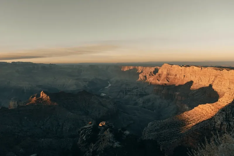
The Grand Canyon Rim-to-Rim is a bucket-list adventure that offers an unparalleled perspective on one of the Seven Natural Wonders of the World. While millions of tourists view the canyon from the rim, only a small fraction—less than one per cent—venture to the bottom. To cross from one rim to the other is to experience the canyon's true scale, silence, and power. The most common route involves descending the South Kaibab Trail, crossing the Colorado River via the Black Bridge, and ascending the North Kaibab Trail. This specific path is favoured for its spectacular, panoramic views during the descent, though it lacks the shade and water found on the alternative Bright Angel Trail.
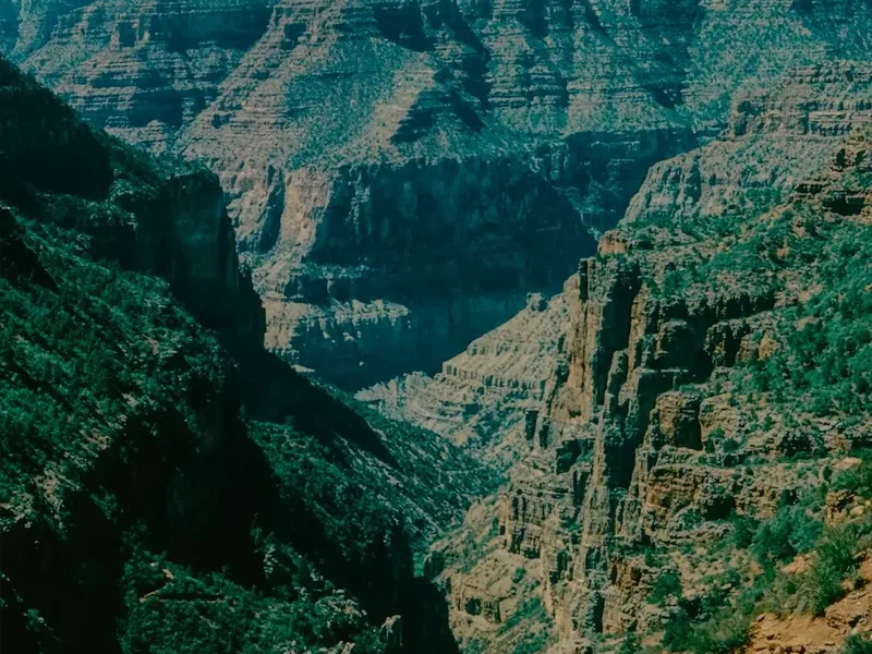
The environmental transition is the most striking feature of the R2R. Hikers begin in a cool, sub-alpine forest environment at the rim. As they descend, they pass through layers of limestone, sandstone, and shale, each representing a different era of the planet's past. By the time they reach the "Inner Gorge," the rock is Vishnu Schist—metamorphic rock that is nearly half the age of the Earth itself. The temperature at the bottom can be 10 to 15 degrees Celsius hotter than at the rim, creating a "reverse mountain" effect where the most difficult climbing occurs in the hottest conditions at the end of the journey.
This is a landscape of extremes. In the summer, temperatures in the inner canyon regularly exceed 40 degrees Celsius, making the hike life-threatening for the unprepared. In the winter, the North Rim is closed due to heavy snow, and the trails can be covered in treacherous ice. Therefore, the "shoulder seasons" of spring and autumn are the coveted windows for this crossing. Whether completed as a grueling single-day "ultra" or a more measured two-day backpacking trip, the Rim-to-Rim requires a level of fitness and logistical planning that few other trails demand. It is a test of the spirit as much as the legs, rewarding those who finish with a sense of accomplishment that lingers long after the dust has been washed from their boots.
History and Cultural Context
The human history of the Grand Canyon stretches back over 12,000 years. For the indigenous peoples of the region—including the Havasupai, Hopi, Hualapai, Navajo, Southern Paiute, and Zuni—the canyon is not just a landmark but a sacred place of origin and a home. Ancient granaries perched high in the cliffs and petroglyphs etched into the desert varnish serve as silent witnesses to centuries of habitation. The Havasupai, in particular, have lived within the canyon's depths for over 800 years, and their connection to the land remains central to their cultural identity today.
European exploration began in 1540 with the arrival of García López de Cárdenas, a Spanish explorer, though the sheer scale of the canyon prevented his party from reaching the river. It wasn't until 1869 that Major John Wesley Powell led the first successful expedition through the canyon by boat, mapping the Colorado River and bringing the canyon's majesty to the attention of the wider world. Powell’s journals described the "Great Unknown" with a mix of scientific rigour and poetic awe, laying the groundwork for the canyon's eventual protection.
The trails used for the Rim-to-Rim today were largely developed in the early 20th century. The South Kaibab Trail was built by the National Park Service in the 1920s to provide a route that the park service controlled, bypassing the privately owned Bright Angel Trail of the time. Much of the infrastructure within the canyon, including the North Kaibab Trail and the famous Phantom Ranch, was constructed or improved by the Civilian Conservation Corps (CCC) during the Great Depression. These young men laboured in extreme conditions to build the stone walls, bridges, and shelters that hikers still use today. Phantom Ranch, designed by architect Mary Colter and completed in 1922, remains the only lodging below the rim, standing as a testament to the "National Park Service Rustic" style of architecture that sought to blend man-made structures into the natural landscape.
Want more background? Read extended notes on history and cultural context → Learn more
Seasonal Highlights and Weather Reality
Timing is the most critical factor in a successful Rim-to-Rim crossing. Because of the massive elevation change, hikers experience several different climates in a single day. The North Rim, being higher in elevation, is significantly cooler and receives much more snow than the South Rim. Consequently, the North Rim facilities—including the lodge and the road access—are only open from mid-May to mid-October.
Spring (April to May): This is one of the most popular times for the R2R. The wildflowers are in bloom, and the temperatures in the inner canyon are generally manageable (25–30 degrees Celsius). However, the North Rim may still have significant snowpack, and the North Kaibab Trailhead can be icy. Hikers must be prepared for winter conditions at the top and desert heat at the bottom.
Summer (June to August): Hiking the Rim-to-Rim in the height of summer is strongly discouraged by the National Park Service. Temperatures at Phantom Ranch and in "The Box" (a narrow, heat-trapping section of the North Kaibab Trail) frequently soar above 45 degrees Celsius. The risk of heatstroke and hyponatremia is extreme. If you must hike during this time, you must be off the trails between 10:00 AM and 4:00 PM, which usually means starting at 3:00 AM.
Autumn (September to October): October is arguably the "Goldilocks" month for the R2R. The summer heat has broken, the North Rim is still accessible, and the changing colours of the aspen trees on the North Rim provide a stunning backdrop. The days are shorter, however, so hikers must be efficient with their time to avoid finishing in the dark.
Winter (November to March): The North Rim is closed to vehicle traffic, making a traditional Rim-to-Rim impossible without a multi-day approach through deep snow. The South Rim remains open, but the trails are often covered in "black ice," requiring crampons or traction devices. This season is for experienced winter backpackers only.
Recommended Itinerary
2-Day Rim-to-Rim Itinerary (South to North)
Day 1: South Rim to Bright Angel Campground
- Distance: 11.3 km (via South Kaibab Trail)
- Elevation loss: 1,460 m
- Time: 4–6 hours
- Start at South Kaibab Trailhead (accessible via the free "Hikers' Express" shuttle)
- Pass Ooh Aah Point (1.5 km) for the first panoramic views of the inner canyon
- Reach Cedar Ridge (2.4 km) – a good spot for a rest and the last toilets before the river
- Descend to Skeleton Point (4.8 km), where the Colorado River first becomes visible
- Navigate the steep switchbacks of "The Tip Off" (7.1 km)
- Cross the Black Bridge over the Colorado River
- Arrive at Bright Angel Campground or Phantom Ranch
- Spend the afternoon cooling off in Bright Angel Creek and resting for the big climb
Day 2: Bright Angel Campground to North Rim
- Distance: 22.5 km
- Elevation gain: 1,780 m
- Time: 7–10 hours
- Early start (before dawn) is essential to beat the heat in "The Box"
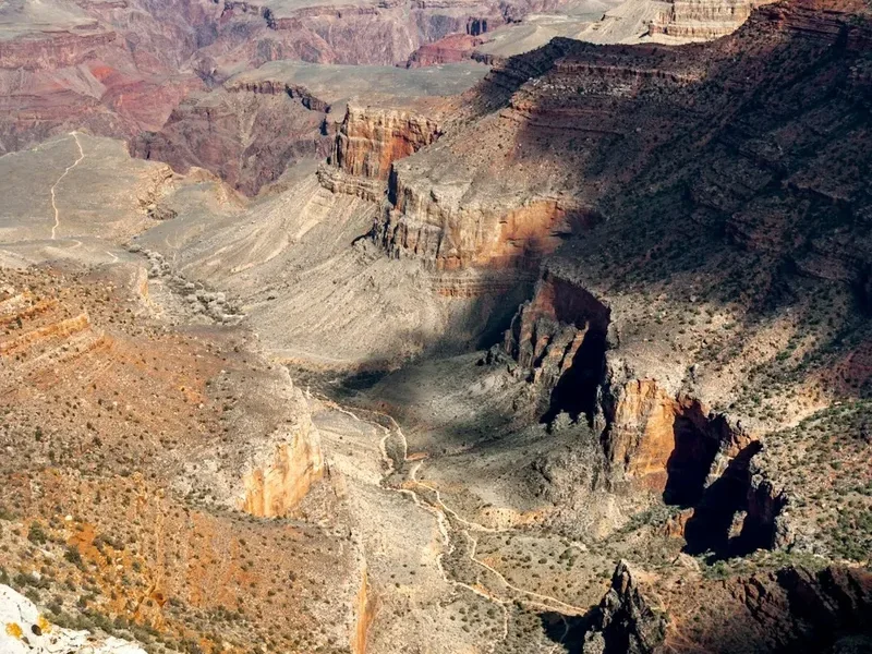
- Walk through "The Box" (first 8 km), a narrow canyon section with towering walls
- Pass Ribbon Falls (optional 2.4 km return detour) – a lush oasis in the desert
- Reach Cottonwood Campground (11.2 km) – the last reliable water source before the final ascent
- Begin the steep climb past Roaring Springs and the Pumphouse Residence
- Navigate the spectacular "Redwall" switchbacks carved directly into the cliff face
- Pass Supai Tunnel (19.3 km) – a hole blasted through the rock with water and toilets
- Final 3.2 km climb through the pine forest to the North Kaibab Trailhead
- Celebrate at the North Rim Lodge with a well-earned meal
Important Notes:
- This itinerary assumes a northbound crossing. Southbound is also common but involves a steeper descent and a slightly less shaded ascent.
- Water availability is subject to pipeline breaks; always check the NPS "Backcountry Updates" page before starting.
- The "Rim-to-Rim-to-Rim" (R2R2R) is a 77 km double crossing that should only be attempted by elite endurance athletes.
- Mule trains have the right of way; always stand on the uphill side of the trail and remain still until they pass.
Planning and Bookings
Book Your Trip
Everything you need to plan your journey
Accommodation
Find places to stay near Flagstaff, Arizona
Flights
Search flights to Flagstaff, Arizona
Essential Preparation
The Grand Canyon Rim-to-Rim is a logistical puzzle that requires planning at least six months in advance. The primary challenge is the distance between the two rims by road—while they are only 16 kilometres apart as the crow flies, it is a 350-kilometre, 4.5-hour drive to get from one trailhead to the other. Most hikers use a commercial shuttle service (such as Trans-Canyon Shuttle) to return to their starting point, which must be booked well in advance.
Physical preparation is non-negotiable. You should be comfortable hiking 20+ kilometres with significant elevation change. Training should focus on "eccentric" loading (descending) to prepare your quadriceps for the 1,400-metre drop, as well as cardiovascular endurance for the long climb out. Flagstaff, Arizona, serves as the best base for preparation, offering high-altitude acclimatisation, gear shops, and easy access to the South Rim.
Trail Accommodation
There are three main options for staying overnight within the canyon, and all are extremely difficult to secure.
Phantom Ranch: The only "hotel" at the bottom of the canyon. It offers rustic cabins and male/female dormitories.
- Booking: Managed via a lottery system 15 months in advance.
- Facilities: Bunk beds, bedding, towels, and a canteen serving pre-booked breakfasts, sack lunches, and steak or stew dinners.
- Cost: High (approx. $200+ USD per night for dorms), but provides the luxury of not carrying a heavy pack.
Bright Angel Campground: Located near Phantom Ranch and the Colorado River.
- Booking: Requires a Backcountry Permit (see Permits section).
- Facilities: Individual campsites with picnic tables, pack poles (to keep squirrels out of food), and flush toilets nearby. No showers.
- Water: Potable water is usually available, but always bring a filter as a backup.
Cottonwood Campground: Located halfway between the river and the North Rim.
- Booking: Requires a Backcountry Permit.
- Facilities: Similar to Bright Angel, but more remote. It is an excellent choice for those who want to break the long North Kaibab ascent into two days.
Required Gear
- Footwear: Well-broken-in hiking boots or trail running shoes with excellent traction. The descent is brutal on toes; ensure your shoes have adequate room.
- Navigation: A physical topographic map and a compass. While the trails are well-marked, GPS can be unreliable in the deep inner gorge.
- Illumination: A high-quality head torch with spare batteries. Many hikers start or finish in the dark.
- Sun Protection: A wide-brimmed hat, polarised sunglasses, and high-SPF sunscreen. The sun in the inner canyon is relentless.
- Emergency Gear: A whistle, a small mirror for signalling, and a basic first aid kit including plenty of moleskin or Leukotape for blisters.
- Traction: If hiking in April or October, "micro-spikes" may be necessary for icy sections near the rims.
What to Bring
- Hydration: A minimum 3-litre capacity (bladder or bottles). Electrolyte powders (like Nuun or Liquid IV) are essential to prevent hyponatremia.
- Food: High-calorie, salty snacks. Think nuts, pretzels, jerky, and energy bars. You will burn 4,000–6,000 calories on a Rim-to-Rim crossing.
- Water Treatment: A lightweight filter (like a Sawyer Squeeze) or purification tablets. Pipeline failures are common, and you may need to draw water from Bright Angel Creek.
- Clothing: Moisture-wicking layers. Avoid cotton. A lightweight "sun shirt" with sleeves is highly recommended. Bring a warm jacket for the rims, where temperatures can drop below freezing at night.
- Toiletries: Biodegradable soap, a small trowel (though toilets are available at campgrounds), and "WAG bags" if required by current park regulations.
Permits
A Backcountry Permit is mandatory for anyone planning to camp overnight below the rim. This does not apply to those staying at Phantom Ranch (which has its own booking system) or those attempting the hike in a single day. However, the National Park Service strongly discourages single-day crossings for most hikers.
The Permit Process:
- Permit applications are accepted starting on the 1st of the month, four months prior to the proposed start month. For example, for an October hike, you must apply on June 1st.
- The process is highly competitive. Applications are processed via a lottery.
- You can apply online through the Pay.gov website or via the official NPS Backcountry Permit page.
- Cost: A non-refundable application fee (approx. $10 USD) plus a per-person, per-night charge (approx. $12 USD).
Last-Minute Permits: If you fail to secure a permit in advance, a limited number of "walk-in" permits are available at the Backcountry Information Centres on both the South and North Rims. You must put your name on a waitlist early in the morning (often 6:00 AM) and hope for a cancellation. This is a risky strategy for a Rim-to-Rim, as it may take several days to get a spot.
Other Activities in the Area
The Grand Canyon region offers a wealth of experiences beyond the Rim-to-Rim trail:
- Desert View Drive: A 40-kilometre scenic drive on the South Rim with multiple pull-outs offering different perspectives of the canyon and the Colorado River.
- Grand Canyon Village Historic District: Explore the El Tovar Hotel, Hopi House, and Lookout Studio—all architectural gems from the early 20th century.
- Helicopter Tours: For those whose legs are too tired to hike, a helicopter flight from Tusayan provides a bird's-eye view of the Dragon Corridor, the widest and deepest part of the canyon.
- Mule Rides: A traditional way to see the canyon. Rides go to the abyss or overnight to Phantom Ranch. These must be booked 15 months in advance.
- Yavapai Geology Museum: Located on the South Rim, this museum offers excellent exhibits on how the canyon was formed and provides one of the best panoramic views of the rock layers.
- Stargazing: The Grand Canyon is an International Dark Sky Park. The lack of light pollution makes for incredible views of the Milky Way.
Safety and Conditions
The "Golden Rule": Down is optional, up is mandatory. Many hikers feel great on the descent and overextend themselves, only to realise they don't have the energy or hydration to make the 1,700-metre climb out. There is no easy way out of the canyon; helicopter evacuations are for life-threatening emergencies only and are extremely expensive.
Heat Management: The inner canyon acts as a heat trap. Between 10:00 AM and 4:00 PM, the sun reflects off the dark Vishnu Schist, creating an oven-like effect. To stay safe:
- Wet your shirt and hat in the creeks to use evaporative cooling.
- Rest in the shade during the hottest part of the day.
- Know the signs of heat exhaustion: dizziness, nausea, and headache.
Hyponatremia vs. Dehydration: Many hikers drink too much plain water without replacing salt, leading to hyponatremia (low blood sodium), which can be fatal. You must eat salty snacks and use electrolyte replacements. If you have a "sloshing" stomach and a headache, you may be over-hydrated.
Water Pipeline: The trans-canyon pipeline that supplies water to the trail is over 50 years old and breaks frequently. Never assume a water station is working. Check the "Critical Backcountry Updates" on the NPS website the morning of your hike. Always carry a backup filtration method.
Wildlife: Do not feed the squirrels. They are the most dangerous animals in the park, frequently biting hikers and carrying diseases. Keep your pack zipped shut. If you encounter a rattlesnake, give it a wide berth and wait for it to move off the trail.
Side Trips and Points of Interest
Ribbon Falls: Located about 10 kilometres from Phantom Ranch on the North Kaibab Trail, this is a literal oasis. A short side trail leads to a 30-metre waterfall that has created a massive, moss-covered travertine dome. It is a perfect place to soak your feet and lower your core temperature before the final climb to the North Rim.
Plateau Point: If you are hiking the Bright Angel Trail instead of the South Kaibab, this 2.4 km (one-way) detour from Indian Garden offers perhaps the best view of the Colorado River in the entire park. You stand on a sheer cliff 400 metres directly above the rushing water.
The Black and Silver Bridges: These two suspension bridges are the only way for hikers to cross the Colorado River. The Black Bridge (South Kaibab) is used by mules and hikers, while the Silver Bridge (Bright Angel) is for hikers only and carries the trans-canyon water pipeline. Walking across them while the green river surges beneath you is a highlight of the trip.
Roaring Springs: Visible from the North Kaibab Trail, this massive spring gushes directly out of a cliff face. It provides all the drinking water for both the North and South Rims—a staggering feat of engineering.
Leave No Trace
The Grand Canyon is a fragile desert ecosystem that sees millions of visitors. To preserve it, hikers must strictly adhere to Leave No Trace principles:
- Pack it in, pack it out: This includes orange peels, nut shells, and tissues. There are no rubbish bins below the rim.
- Stay on the trail: "Social trails" cause erosion and destroy biological soil crusts (cryptobiotic soil) that take decades to grow.
- Dispose of waste properly: Use the provided toilets at campgrounds and rest houses. If you must go between stations, bury solid human waste 15–20 cm deep and at least 60 metres from water.
- Respect the silence: Use headphones if you must listen to music. The sound of the wind and the river is part of the wilderness experience.
- Leave what you find: It is illegal to remove rocks, plants, or archaeological artefacts from the National Park.